
An encyclopedia of Middle-earth and Numenor
|
|
|
|
|
|
|
|
|
|
|
|
|
|
| |
|
|
An encyclopedia of Middle-earth and Numenor |
|

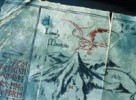
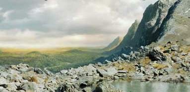
Blackroot Vale |
The
Blackroot Vale by Ted Nasmith
|
 Valley
on the southern side of the White Mountains
in Gondor. The Blackroot Vale was a dark valley
in the shadow of two high mountains on either side. The valley had steep,
grassy slopes. The land in the valley was rich and many people lived there.
Valley
on the southern side of the White Mountains
in Gondor. The Blackroot Vale was a dark valley
in the shadow of two high mountains on either side. The valley had steep,
grassy slopes. The land in the valley was rich and many people lived there.
At the northern end of the valley, the Blackroot River issued from a door to the Paths of the Dead. The river flowed south through the valley and a road ran alongside it. Near the southern end of the valley was the Hill of Erech, upon which was the Stone of Erech. The Dead sometimes gathered around the Stone of Erech and the people of the Blackrook Vale were afraid to go near it.
Aragorn and the Grey Company emerged from the Paths of the Dead into the Blackroot Vale on March 8, 3019 of the Third Age. They rode through the valley with the Dead following behind and the people who lived there fled in terror. At midnight at the Stone of Erech, Aragorn summoned the Dead to fulfill their oath to fight the servants of Sauron.
A company of 500 archers from the Blackroot Vale went to the aid of Minas Tirith during the War of the Ring. They were led by Duinhir and his sons Derufin and Duilin. During the Battle of the Pelennor Fields, the archers fought valiantly and slew a number of Oliphaunts. Duilin and Derufin were both trampled to death by Oliphaunts and never returned to the Blackroot Vale.
Names &
Etymology:
Also called the Morthond Vale
or the Mornan.
The Blackroot Vale was named for the river whose source was in the dark caverns of the Dead. The name Morthond means "Blackroot" from mor meaning "black" and thond meaning "root." The name Mornan means "dark valley"; the word nan means "valley."
Sources:
The Return
of the King: "Minas Tirith," p. 43; "The Passing of the Grey Company,"
p. 61-63; "The Battle of the Pelennor Fields," p. 124-25; "The Houses of
Healing," p. 134
Appendix
E of The Lord of the Rings: "Writing and Spelling," p. 393
"Nomenclature
of The Lord of the Rings," entry for Blackroot Vale
"The Rivers
and Beacon-hills of Gondor," by J.R.R. Tolkien, edited by Carl F. Hostetter,
commentary by Christopher Tolkien, in Vinyar Tengwar #42, July 2001,
p. 14
Deeping-coomb |
Map
of the Deeping-coomb
|
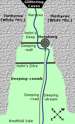 Valley
in Rohan where Helm's
Deep was located. The Deeping-coomb was in the northwestern spur of
the White Mountains near the Gap
of Rohan. It lay between the arms of the three-peaked mountain called
the Thrihyrne.
Valley
in Rohan where Helm's
Deep was located. The Deeping-coomb was in the northwestern spur of
the White Mountains near the Gap
of Rohan. It lay between the arms of the three-peaked mountain called
the Thrihyrne.
The Deeping-coomb opened onto the Westfold Vale, a fertile region with many homesteads in western Rohan. Long green grass grew in the Deeping-coomb. The eastern side of the coomb was sheer and rocky and could not be climbed, while on the western side there were long slopes.
The Deeping-coomb appears to have been situated at an angle, running back into the mountains from the northeast to the southwest. The Deeping-coomb gradually became steeper and narrower until it formed the ravine known as Helm's Deep.
About two furlongs - or a quarter mile - before Helm's Deep, a defensive trench and rampart called Helm's Dike spanned the Deeping-coomb. Beyond Helm's Dike, a grassy slope rose gently to the Deeping-wall across Helm's Gate - the entrance to the ravine of Helm's Deep.
The Deeping-wall was guarded by the Hornburg - a fortress built on the Hornrock which jutted from the cliff on the northwestern side of the ravine. The cliffs of the ravine closed in to form the Narrows. At the far end of the ravine was the entrance to the Glittering Caves.
The Deeping-stream flowed from the Glittering Caves. It passed through a culvert under the Deeping-wall and through a breach in Helm's Dike and then flowed through the Deeping-coomb and out into the Westfold Vale. The Deeping-road from the Hornburg ran alongside the stream and joined the Great West Road.
The defenses in the Deeping-coomb were built by the Men of Gondor during the reign of the Ship-kings (830-1149 of the Third Age) to guard Gap along with Isengard. In 2510, the Deeping-coomb became part of the new land of Rohan.
In 2758, Rohan was invaded by Men of Dunland. King Helm of Rohan and many of his people took refuge in the stronghold that was afterwards called Helm's Deep. The Rohirrim were besieged during the Long Winter of 2758-59. Helm froze to death standing on Helm's Dike in the Deeping-coomb. The invaders were driven out by Helm's nephew Frealaf in the spring of 2759.
At the time of the War of the Ring, Erkenbrand was the Lord of the Westfold as well as the Lord of the Deeping-coomb and he lived in the Hornburg. He repaired and strengthened the defenses of Helm's Deep. Many people of the Westfold took refuge in the Glittering Caves when Saruman launched an invasion from Isengard.
On March 3, 3019, the Deeping-coomb was overrun by Saruman's army of 10,000 Orcs and Men. They drove the defenders from Helm's Dike and came to the Deeping-wall. The Battle of Helm's Deep was waged through the night as the Rohirrim led by King Theoden tried to prevent the enemy from capturing the stronghold.
At dawn on March 4, King Theoden led a charge from the Hornburg. At the same time, Erkenbrand and Gandalf arrived with reinforcements and came down the western slopes of the Deeping-coomb. During the night, Huorns from Fangorn Forest had filled the Deeping-coomb, trapping Saruman's army from behind. The Men of Dunland surrendered and the Orcs fled into the forest of Huorns and were all slain.
After the battle, the dead were buried in the Deeping-coomb. Near the Deeping-road between the Deeping-wall and Helm's Dike two mounds were made for the Rohirrim: one for the Men of the Westfold and one for the Men of the East Dales. Hama had a solitary grave near the Hornburg. The dead of Dunland were buried below Helm's Dike.
The Orcs were left in a pile near the Huorn forest. During the night of March 4, the Huorns buried the Orcs a mile below Helm's Dike in a great pit covered with stones. The grave was called the Death Down. Grass did not grow there and Men avoided it. The Huorns returned to Fangorn leaving no sign of the temporary forest except for trampled grass in the Deeping-coomb.
Names &
Etymology:
A coomb is a deep hollow
or narrow valley. The Deeping-coomb was so called because it was
the valley of Helm's Deep. The correct form is the hyphenated Deeping-coomb
although it appears in some editions as Deeping Coomb. Also called
simply the Deeping or the Coomb.
Sources:
The Two
Towers: "Helm's Deep," p. 133-47; "The Road to Isengard," p. 148-55,
158
The Return
of the King: "The Passing of the Grey Company," p. 48-56; "Many Partings,"
p. 257
Appendix
A of The Lord of the Rings: "The House of Eorl," p. 347-48
Unfinished
Tales: "The Battles of the Fords of Isen," p. 358, 365 note 6, 368
The History
of Middle-earth, vol. VIII, The War of the Ring: "Helm's Deep," p.
12; "The Road to Isengard," p. 40; "Book Five Begun and Abandoned," p.
268-70
The Lord
of the Rings: A Reader's Companion by Wayne G. Hammond and Christina
Scull: "Helm's Deep," p. 413-15
"Nomenclature
of The Lord of the Rings," entries for Coomb and Deeping
Coomb
The Atlas
of Middle-earth by Karen Wynn Fonstad: "Helm's Deep," p. 132-33
Derndingle was shaped like a bowl; it was deep, round, and wide. It was surrounded by a hedge of evergreen trees that had dark glossy leaves and flower-spikes with olive-colored buds. There were three entrances into the dell through the hedge: from the north, west, and east. From the entrances, paths led down to the center of the dell where three tall, beautiful silver-birches stood. There were no other trees in the dell; the ground was smooth and grassy. In the north bank of the dell there was a well from which a fountain of water gushed.
Derndingle was where the Ents traditionally gathered to discuss matters of importance. During the War of the Ring at the end of the Third Age, an Entmoot was held there to decide what to do about Saruman, who had been cutting down trees in Fangorn and expanding his power. Treebeard brought Merry Brandybuck and Pippin Took to Derndingle on the morning of February 30, 3019. They were joined by about fifty Ents. The Entmoot lasted for three days. On the afternoon of March 2, the Ents decided to go to war against Saruman. They marched out of Derndingle, singing as they went, and headed south to Isengard.
Names &
Etymology:
Derndingle was the Common
Speech name given to the dell by Men. The word dern means "secret,
hidden" and a dingle is a small, deep, shady valley.
Sources:
The Two
Towers: "Treebeard," p. 82-90
"Nomenclature
of The Lord of the Rings," entry for Derndingle
Dimrill Dale |
Dimrill
Dale in the New Line film
|
 Valley
on the eastern side of the Misty Mountains.
Dimrill Dale was formed by the arms of the three Mountains of Moria: Silvertine,
Cloudyhead,
and Redhorn. The northern end of the
dale lay in deep shadow. There at the head of the dale the Dimrill
Stair descended from the Redhorn Gate.
Beside the stair, a stream called the Dimrill
cascaded in a series of short falls.
Valley
on the eastern side of the Misty Mountains.
Dimrill Dale was formed by the arms of the three Mountains of Moria: Silvertine,
Cloudyhead,
and Redhorn. The northern end of the
dale lay in deep shadow. There at the head of the dale the Dimrill
Stair descended from the Redhorn Gate.
Beside the stair, a stream called the Dimrill
cascaded in a series of short falls.
A long, oval lake called Mirrormere stretched from north to south in the dale. The Dimrill flowed into its northern end. At the southern end of Mirrormere was the source of the Silverlode. It was a deep well from which the icy waters spilled over a stone lip into a rocky channel. The Silverlode was joined by other mountain streams as it ran southeast to the Anduin.
The East-gate of Moria was on the western side of Dimrill Dale. A paved road ran from the gate down to Mirrormere and then turned southwards and led out of the dale. Birch and fir trees grew on mounds along the road and the Dwarves had erected works of stone along it as well. Beside Mirrormere was a pillar called Durin's Stone. There Durin was said to have looked into the waters of the mere and the seven stars of his crown could be seen in the depths.
Durin was the eldest of the Seven Fathers of the Dwarves, and he came to Dimrill Dale after he awoke in ancient times. There under the mountains Durin founded the realm of Khazad-dum that was later called Moria. Dimrill Dale was part of this realm. In the year 1980 of the Third Age, as the Dwarves delved for mithril, a Balrog that had lain under the mountains since the First Age emerged from the depths and slew Durin's descendant Durin VI. The Dwarves fled from Khazad-dum in 1981.
In 2790, Thror decided to return to Khazad-dum. He descended the Dimrill Stair into Dimrill Dale and entered the East-gate but he was slain by the Orc leader Azog. Thror's companion Nar hid in the dale for many days until Azog threw Thror's body from the East-gate; then Nar returned to his people with news of what had happened.
Thror's son Thrain mustered an army of Dwarves and launched a war against the Orcs of the Misty Mountains in 2793. In 2799 the Dwarves came to Dimrill Dale and fought the Orcs in the Battle of Azanulbizar. Azog was slain by Dain Ironfoot and the Dwarves were victorious, though they had suffered much loss. They felled many trees in the Dimrill Dale to burn their dead, and few trees grew in the valley thereafter. The Dwarves did not reclaim Khazad-dum, for Dain had looked through the East-gate into Moria and became aware that Durin's Bane, the Balrog, still lurked there.
Balin led a group of Dwarves to Khazad-dum in 2989. When they arrived in the Dimrill Dale, they found Orcs guarding the East-gate. A Dwarf named Floi was slain by an arrow and was buried in the dale, but the Dwarves slew many Orcs and drove them away from the gate. Balin established a colony in Khazad-dum that lasted five years. On November 10, 2994, Balin went into Dimrill Dale to look into Mirrormere and was shot and killed by an Orc. The colony was overwhelmed and all the Dwarves were slain.
The Fellowship journeyed through Moria and emerged from the East-gate into Dimrill Dale on January 15, 3019. Gimli led Frodo Baggins and Sam Gamgee to look into the waters of Mirrormere where they saw the stars of Crown of Durin. The Fellowship the followed the road past the springs of the Silverlode and out of Dimrill Dale to the woods of Lothlorien. When the Fellowship left Lothlorien, Haldir told them that Dimrill Dale was filled with vapor and smoke. It was later learned that this disturbance was caused by the Battle of the Peak between Gandalf and the Balrog on the Silvertine.
Names &
Etymology:
Also called Azanulbizar by
the Dwarves and Nanduhirion by the Elves.
The Common Speech name Dimrill Dale comes from dim - referring to the deep shadows in the dale - and rill - a small stream or rivulet such as those flowing down the mountains into the dale.
There are two slightly different translations of the Dwarvish name Azanulbizar. In HoME VI it is said to mean "Vale of Dim Streams" from the root ZN meaning "dark, dim," ûl meaning "streams," and bizar meaning "dale, valley." But in a draft manuscript cited in The Reader's Companion, azan is said to be the plural of uzu meaning "dimness, shadow" while ul means "of" and bizar is a plural of the root BZR meaning "small stream." Thus Azanulbizar means "streams of the shadows" and the full name was Duban Azanulbizar where duban means "valley."
The Elvish name Nanduhirionalso means "vale of dim streams." The word nan means "valley." The word dú means "night, dimness." The ending hirion comes from sirion meaning "rivers, streams." (The letter s becomes h in the middle of a word.)
Sources:
The Fellowship
of the Ring: "The Ring Goes South," p. 287, 296; "A Journey in the
Dark," p. 310, 323, 328, 329, 332; "The Bridge of Khazad-dum," p. 335-36,
346; "Lothlorien," p. 347-49, 356, 357; "Farewell to Lorien," p. 387
The Return
of the King: "Many Partings," p. 263
Appendix
A of The Lord of the Rings: "Durin's Folk," p. 352-57
"Nomenclature
of The Lord of the Rings," entry for Dimrill Dale
The Silmarillion:"Appendix
- Elements in Quenya and Sindarin Names," entries for nan(d),
dú,
and sîr
The History
of Middle-earth, vol. VI, The Return of the Shadow: "The Mines of Moria,"
p. 466, note 36 (definition of Azanulbizar)
The Lord
of the Rings: A Reader's Companion by Wayne G. Hammond and Christina
Scull: "The Ring Goes South," p. 269 (alternate definition of Azanulbizar)
Names &
Etymology:
The name Firien-dale means
"mountain valley" from the Anglo-Saxon firgen-dael.
Sources:
Unfinished
Tales: "Cirion and Eorl," p. 300, 314 note 33
Harrowdale |
Map
of Harrowdale
|
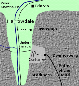 Valley
in the White Mountains in Rohan.
Harrowdale was located near the northwestern end of the White Mountains,
about 125 miles from the Gap of Rohan.
It was a deep valley with high mountains on each side. There were pine
trees on the slopes and rough grass on the floor of the valley.
Valley
in the White Mountains in Rohan.
Harrowdale was located near the northwestern end of the White Mountains,
about 125 miles from the Gap of Rohan.
It was a deep valley with high mountains on each side. There were pine
trees on the slopes and rough grass on the floor of the valley.
On the eastern side of Harrowdale were three great peaks: Irensaga on the northern end, the Dwimorberg in the middle, and the Starkhorn to the south. The refuge of Dunharrow was high up on the slopes of these three mountains, and could be reached by a zigzag path from the valley of Harrowdale below. Ancient statues called the Pukel-men stood at each turning of the path. Beyond Dunharrow in the Dwimorberg was the entrance to the Paths of the Dead. At times, the Dead emerged from the Dark Door, and the people of Harrowdale would hide in their houses.
The River Snowbourn flowed northward through Harrowdale along the western side of the valley. There was a road on its eastern bank leading out of the valley. At least one other stream flowed down from the western slopes of Harrowdale to join the Snowbourn. Another road came down from the western slopes and crossed a ford over the Snowbourn and then led to the path to Dunharrow.
At the entrance to the valley stood a hill upon which the town of Edoras was built. There were two small villages in Harrowdale named Underharrow and Upbourn. Harrowdale was one of the more populous regions of Rohan. The Rohirrim began to settle in the valley during the reign of King Aldor (2570-2645 of the Third Age). The people of Harrowdale had their own chieftain. At the time of the War of the Ring, Dunhere was the Lord of Harrowdale.
On Gandalf's advice, the Muster of Rohan was held in Harrowdale to shield the gathering forces from the watchful eyes of the Winged Nazgul. Starting on March 6, 3019, the Riders began to gather in the valley. Eowyn was in charge of organizing the troops until King Theoden arrived. Tents and booths were set up in the valley and arms and provisions were gathered.
The King arrived on the night of March 9, and the next day on March 10 he oversaw the Muster of Rohan. An eohere of 6,000 Rohirrim was assembled in Harrowdale, and they passed through the villages of Underharrow and Upbourn and out of the valley to begin their journey to Gondor. At the Battle of the Pelennor Fields on March 15, Dunhere, the Lord of Harrowdale, was killed.
Etymology:
Harrowdale means "valley
of the (heathen) temple" from the Old English hearg meaning "temple,
sanctuary, idol" and dale meaning "valley." The name referred to
the refuge of Dunharrow, which had once been a sacred site to the ancient
Men who dwelled there before the Rohirrim.
Sources:
The Return
of the King: "The Passing of the Grey Company," p. 56-60; "The Muster
of Rohan," passim
Unfinished
Tales: "The Battles of the Fords of Isen," p. 366 note 13
"Nomenclature
of The Lord of the Rings," entry for Dunharrow
Old English
The wise-woman Ioreth was reminded of the roses of Imloth Melui when she first smelled athelas in the Houses of Healing. Ioreth may have originally come from Imloth Melui. She had a kinswoman from the valley who attended the coronation of Aragorn, King Elessar.
Names &
Etymology:
Imloth Melui means "sweet
flower valley." The element im denotes "valley," possibly derived
from am meaning "up, slope." The element loth means "flower,
blossom." The word melui means "sweet, lovely" derived from mel
meaning "love."
Sources:
The Return
of the King: "The Houses of Healing," p. 142; "The Steward and the
King," p. 244
The History
of Middle-earth, vol. V, The Lost Road and Other Writings: "The Etymologies,"
entries for AM2, LOT(H) and MEL
"The Rivers
and Beacon-hills of Gondor," by J.R.R. Tolkien, edited by Carl F. Hostetter,
commentary by Christopher Tolkien, in Vinyar Tengwar #42, July 2001,
p. 18
The Lord
of the Rings: A Reader's Companion by Wayne G. Hammond and Christina
Scull: "The Houses of Healing," p. 582
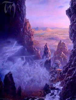
Morgul Vale |
Map
of the Morgul Vale
|
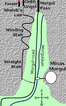 Valley
in the Mountains of Shadow on the
border of Mordor. The Morgul Vale was on the
western side of the mountains, opening onto the land of Ithilien.
It was a deep ravine with jagged cliffs on either side that cast dark shadows
into the valley. The ground sloped upward as the valley stretched back
into the mountains.
Valley
in the Mountains of Shadow on the
border of Mordor. The Morgul Vale was on the
western side of the mountains, opening onto the land of Ithilien.
It was a deep ravine with jagged cliffs on either side that cast dark shadows
into the valley. The ground sloped upward as the valley stretched back
into the mountains.
On the northern side of the Morgul Vale were the Stairs of Cirith Ungol. The Straight Stair and the Winding Stair climbed the steep mountainside overlooking the valley. At the top was a tunnel that was the lair of the Great Spider Shelob, and beyond was the pass called Cirith Ungol guarded by the Tower of Cirith Ungol.
The main pass over the mountains was the Morgul Pass at the eastern end of the Morgul Vale. The Morgul-road ran down from the Morgul Pass and through the valley, continuing on through Ithilien to Osgiliath on the River Anduin.
A river called the Morgulduin also came down from the mountains and through the Morgul Vale to the Anduin. Near the mouth of the valley, the road passed over the Morgulduin by way of a white bridge guarded by hideous statues. The waters of the Morgulduin were poisonous, and on the riverbanks were deadly white flowers that gave off a terrible odor.
On the southern side of the Morgul Vale stood Minas Morgul perched on the mountainside overlooking the valley. Minas Morgul was originally a stronghold of Gondor called Minas Ithil, but it was captured by the Nazgul in 2002 of the Third Age. The Morgul Vale became a place of evil "where the minds of living men would turn to madness and horror." (RotK, p. 161)
The Lord of the Nazgul assembled an army of Orcs in Minas Morgul. During the War of the Ring on March 10, 3019, his led his army forth to attack Minas Tirith. Frodo Baggins and Sam Gamgee came to the Morgul Vale that same day and witnessed the army's departure. The Hobbits were then led by Gollum up the Stairs of Cirith Ungol to Shelob's Lair.
On March 19, as the armies of Gondor and Rohan marched to the Black Gate, they broke the bridge over the Morgulduin and set fire to the fields of deadly flowers. After the War of the Ring, Aragorn, King Elessar, decreed that Minas Morgul should be destroyed. The Morgul Vale remained uninhabitable for many long years to come. One of the duties of Faramir, the Prince of Ithilien, was to begin to cleanse the Morgul Vale of the taint of evil.
Names &
Etymology:
The name Morgul Vale means
"valley of black magic." The element mor means "black, dark." The
element gûl means "sorcery, magic" from the stem ngol
or nólë meaning "long study, lore, knowledge."
Also called the Morgul Valley, the Valley of the Wraiths and the Valley of Living Death.
The Sindarin translation of Morgul Vale is Imlad Morgul. The word imlad means "narrow valley with steep sides."
The original name of the Morgul Vale is not known. A reasonable guess - based on the previous names of Minas Morgul (Minas Ithil) and the Morgulduin (Ithilduin) - would be Ithil Vale, or Imlad Ithil. This name would mean "valley of the moon."
Sources:
The Two
Towers: "The Black Gate Is Closed," p. 249-52; "The Forbidden Pool,"
p. 300-2; "Journey to the Cross-roads," p. 303, 306, 308; "The Stairs of
Cirith Ungol," p. 312-20; "Shelob's Lair," p. 326
The Return
of the King: "The Black Gate Opens," p. 160-61. 163; "The Steward and
the King," p. 236, 247
The Silmarillion:
"Appendix - Elements in Quenya and Sindarin Names," entry for lad
The Letters
of J.R.R. Tolkien: Letter #244
The tombs of the Kings and Queens of Numenor were in chambers carved into the mountainside at the head of the valley. All the rulers of Numenor were laid to rest there except Ar-Pharazon, the last, who perished in an attack on the Undying Lands that resulted in Numenor's destruction in 3319 of the Second Age.
Names &
Etymology:
The name Noirinan means "Valley
of the Tombs" in Quenya from noirë meaning "tomb" and nan
meaning "valley."
Sources:
Unfinished
Tales: "A Description of the Island of Numenor," p. 166, 168-69
Quenya-English
Wordlist
During the War of the Ring, 300 Men from the Ringlo Vale came to strengthen the defenses of Minas Tirith. They were led by Dervorin, the son of the Lord of the Ringlo Vale.
Names &
Etymology:
The name Ringló means
"chill flood" from ring meaning "cold" and lô meaning
"soaking wet, swampy, flood."
Sources:
The Return
of the King: "Minas Tirith," p. 43
"The Rivers
and Beacon-hills of Gondor," by J.R.R. Tolkien, edited by Carl F. Hostetter,
commentary by Christopher Tolkien, in Vinyar Tengwar #42, July 2001,
p. 10, 13-14
By the end of the Third Age, the road through the valley had been forgotten by many, but it was known to the Druedain who inhabited the Druadan Forest. On March 13, 3019, Ghan-buri-Ghan of the Druedain offered to guide King Theoden and the Rohirrim through the Stonewain Valley in order to avoid the armies of the Enemy on the Great West Road. Theoden accepted his offer, and the Rohirrim travelled in secret through the valley to the Rammas Echor encircling Minas Tirith. There at dawn on March 15 they came to the aid of Gondor in the Battle of the Pelennor Fields.
Names &
Etymology:
The name Stonewain refers
to the fact that wains - or wagons - carrying stone passed through the
valley.
The Sindarin name was Imrath Gondraich. The word imrath means "long narrow valley with a road or water course." The word gond means "stone" and raich apparently meaning "wagons."
Note that the name is spelled Imrath Gondraich in the Unfinished Tales index, but the Reader's Companion gives a different spelling of Imrath Gondraith taken from Tolkien's unpublished index to The Lord of the Rings.
Sources:
The Return
of the King: "The Ride of the Rohirrim," p. 106-110; "The Tower of
Cirith Ungol," p. 173
Unfinished
Tales: "Cirion and Eorl," p. 319 (note 51); "The Druedain," p. 382;
Index, p. 465
The Lord
of the Rings: A Reader's Companion by Wayne G. Hammond and Christina
Scull: "The Ride of the Rohirrim," p. 558
The Encircling Mountains formed a tall, nearly impenetrable ring around Tumladen. In the north where the mountains were highest was a narrow pass called the Eagles' Cleft overlooking a deep abyss. In the south were the peaks of the Crissaegrim where Thorondor and the Great Eagles had their eyries.
On the west was the Hidden Way into Gondolin. The Dry River led to a tunnel under the mountains. At the end of the tunnel was Orfalch Echor, a long ravine sloping upwards to the edge of Tumladen. Orfalch Echor was barred by the Seven Gates. Beyond the Last Gate, slopes ran down to the grassy plain on the valley floor.
In ancient times, the valley of Tumladen was filled with a great lake. The Hidden Way under the mountains was carved by a stream that flowed out to join the Sirion. When the waters in the valley receded, the stream became the Dry River.
Turgon found the hidden valley in the year 53 of the First Age with the help of Ulmo, Lord of Waters. Upon Amon Gwareth, Turgon and his people began the construction of Gondolin, which was completed in 116.
In 510, Morgoth's forces invaded Tumladen over the mountains in the north and Gondolin was destroyed. Idril had prepared a secret tunnel out of the city which ran northwards for a ways under the valley floor. A number of survivors including Idril, Tuor, and Earendil escaped through this tunnel and emerged on the plain north of the city. The valley was full of smoke from the burning of Gondolin and steam from the city's many fountains, and the survivors were hidden from the enemy forces.
The survivors climbed the Eagles' Cleft out of the valley but were ambushed by Orcs and a Balrog. Glorfindel battled the Balrog and they both fell to their deaths. Thorondor retrieved Glorfindel's body and he was buried near the pass. The refugees continued onward and settled at the Havens of Sirion.
Names &
Etymology:
The name Tumladen means "wide
valley" from tûm meaning "valley" and laden meaning
"open, cleared." Tumladen was also the name of
a valley in Gondor.
Sources:
The Silmarillion:
"Of the Return of the Noldor," p. 115; "Of the Noldor in Beleriand," p.
125; "Of Maeglin," p. 134; "Of the Ruin of Beleriand," p. 158; "Of Beren
and Luthien," p. 182; "Of Tuor and the Fall of Gondolin," p. 239-41, 243;
Index entry for Tumladen; "Appendix - Elements in Quenya and Sindarin
Names," entry for tum
The History
of Middle-earth, vol. V, The Lost Road and Other Writings: "The Etymologies,"
entry for LAT
Names &
Etymology:
The name Tumladen means "wide
valley" from tûm meaning "valley" and laden meaning
"open, cleared." Tumladen was also the
name of the valley in Beleriand where Gondolin
was located.
Sources:
The Return
of the King: "Minas Tirith," p. 36
The Silmarillion:
Index entry for Tumladen; "Appendix - Elements in Quenya and Sindarin
Names," entry for tum
The History
of Middle-earth, vol. V, The Lost Road and Other Writings: "The Etymologies,"
entry for LAT
The Lord
of the Rings: A Reader's Companion by Wayne G. Hammond and Christina
Scull: "Minas Tirith," p. 521
Udûn |
Map
of Udun
|
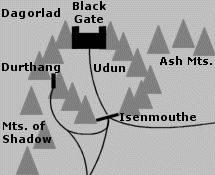 Valley
in Mordor. Udun was located in the northwestern
corner of Mordor, where the Mountains
of Shadow met the Ash Mountains. At
one end of the valley was the Black
Gate across Cirith Gorgor, the
Haunted Pass, flanked on either side by the Towers
of the Teeth. At the opposite end was the narrow pass called Isenmouthe,
which was barred by a fence of pointed iron posts, an earthen wall, and
a trench spanned by a narrow bridge. A road ran through Udun from the Black
Gate to Isenmouthe and then branched into two roads to Cirith
Ungol and Barad-dur.
Valley
in Mordor. Udun was located in the northwestern
corner of Mordor, where the Mountains
of Shadow met the Ash Mountains. At
one end of the valley was the Black
Gate across Cirith Gorgor, the
Haunted Pass, flanked on either side by the Towers
of the Teeth. At the opposite end was the narrow pass called Isenmouthe,
which was barred by a fence of pointed iron posts, an earthen wall, and
a trench spanned by a narrow bridge. A road ran through Udun from the Black
Gate to Isenmouthe and then branched into two roads to Cirith
Ungol and Barad-dur.
There were many Orc-holds, armories, and tunnels in the mountains on either side of Udun. These were used by the troops guarding the Black Gate. The castle of Durthang was on the western side of the valley, and there were other forts and towers on either side of the Isenmouthe.
In late March 3019 of the Third Age, troops came from across Mordor and gathered in Udun preparing to face the Men of Gondor and Rohan who were approaching the Black Gate. Frodo Baggins and Sam Gamgee - who were disguised as Orcs - were forced to join a troop heading for Udun on March 18 but managed to escape the next day.
On March 25, the Black Gate opened and Sauron's forces came forth from Udun, and they fought the Men of the West in the Battle of the Morannon. Then the One Ring was destroyed in Mount Doom and Sauron was utterly defeated. His forces scattered, and Mordor fell into ruin. The Black Gate at the entrance to Udun was hurled down, and the Towers of the Teeth collapsed.
Names &
Etymology:
The name Udûn means
"dark pit" or "Hell." It is the Sindarin form of the Quenya Utumno,
which was the name of Morgoth's terrible underground stronghold in ancient
times. The name Utumno is derived from tum or tumbo
meaning "deep valley under or among hills."
Sources:
The Return
of the King: "The Land of Shadow," p. 205, 208-209; "The Field of Cormallen,"
p. 227-28; Index entry p. 436 (Udun = Hell)
The Silmarillion:
"Appendix - Elements in Quenya and Sindarin Names," entry for tum
The History
of Middle-earth, vol. V, The Lost Road and Other Writings: "The Etymologies,"
entry for TUB
"Nomenclature
of The Lord of the Rings," entry for Isengard and Isenmouthe
The Lord
of the Rings: A Reader's Companion by Wayne G. Hammond and Christina
Scull: "The Bridge of Khazad-dum," p. 297 (Udun=dark pit)
Wizard's Vale |
Map
of the Wizard's Vale
|
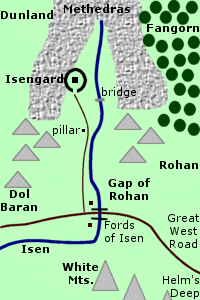 Valley
where Isengard was located. The Wizard's Vale
was at the southern end of the Misty Mountains
under the shadow of Methedras, the
Last Peak. The valley was sheltered between the arms of the mountains with
foothills on its eastern and western sides. Dol
Baran was the last hill on the western side of the valley. The Wizard's
Vale opened southward onto the Gap of Rohan.
Valley
where Isengard was located. The Wizard's Vale
was at the southern end of the Misty Mountains
under the shadow of Methedras, the
Last Peak. The valley was sheltered between the arms of the mountains with
foothills on its eastern and western sides. Dol
Baran was the last hill on the western side of the valley. The Wizard's
Vale opened southward onto the Gap of Rohan.
The River Isen began in the mountains at the head of the Wizard's Vale and flowed southward through the valley. A number of mountains streams fed into the Isen from both sides of the valley. A bridge spanned the river about a mile from Isengard. In the Gap of Rohan, the Great West Road and the North-South Road met at the Fords of Isen. Past the Fords, the Isen curved westward to the Sea.
A highway ran from the Fords through the Wizard's Vale to Isengard. The paved highway ran alongside the west bank of the Isen for much of the way. As the highway approached the south gate of Isengard it became a wide street of flat stones. This juncture was marked by a tall black pillar topped with Saruman's emblem of the White Hand pointing north.
Isengard was about 16 miles into the Wizard's Vale. The circular wall of Isengard was joined to the cliffs on the western side of the valley. The Ring of Isengard was one mile in diameter, and within it stood the Tower of Orthanc.
The Wizard's Vale was originally lush and green with groves of ancient trees. But Saruman had the trees cut down to use as fuel for his forges and furnaces. The valley became overgrown with brambles and weeds and it was a dismal place. There were a few acres of land near the walls of Isengard where crops were grown by slave labor.
During the War of the Ring, Treebeard and the Ents attacked Isengard and tore down its outer wall. The White Hand was thrown down from the pillar and smashed. The Ents temporarily diverted the Isen and flooded Isengard to douse Saruman's furnaces and forges and clean away the filth. A lake was formed around the Tower of Orthanc. The Ents planted orchards and gardens around the lake called the Treegarth of Orthanc, and they set to work restoring the natural beauty of the valley.
After the War of the Ring, Aragorn, King Elessar, gave the Wizard's Vale to the Ents so that they could expand Fangorn Forest westward.
Names and
Etymology:
Also called the Valley of Saruman.
The Sindarin name for the Wizard's Vale was Nan Curunír.
The word nan means "valley." Curunír was the Sindarin
name for Saruman, meaning "the one of cunning devices" or "wizard" from
curu
meaning "craft, skill" and nír, a lenited form of dir,
a masculine ending.
Sources:
The Two
Towers: "Treebeard," p. 90; "Helm's Deep," p. 131; "The Road to Isengard,"
p. 157-64; "Flotsam and Jetsam," passim; "The Voice of Saruman," passim;
"The Palantir," p. 191-201
The Return
of the King: "Many Partings," p. 257-60
The Silmarillion:
"Appendix - Elements in Quenya and Sindarin Names," entry for nan(d)
The History
of Middle-earth, vol. V, The Lost Road and Other Writings: "The Etymologies,"
entry for DER and KUR
The History
of Middle-earth, vol. VIII, The War of the Ring: "Helm's Deep," p.
8
Nan Curunir
All entries are Copyright © by the Thain from former tuckborough.net. Please contact me if you are Thain or know anything about how to contact the original author.
2003-2011, The Thain's Book - thainsbook.minastirith.cz
- e-mail: thain at tuckborough.net