
An encyclopedia of Middle-earth and Numenor
|
|
|
|
|
|
|
|
|
|
|
|
|
|
| |
|
|
An encyclopedia of Middle-earth and Numenor |
|

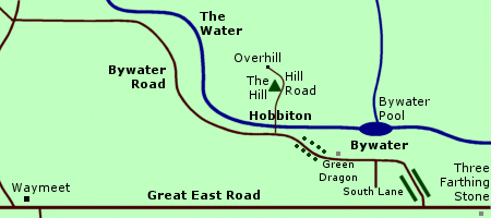
The Bywater Road began a short distance west of the Three-Farthing Stone. The first section of road ran on an upward slope between two high banks topped with hedges. In the village of Bywater, the road skirted Bywater Pool. The stretch of road along Pool Side was lined with trees. In the middle of the village, the South Lane branched off the Bywater Road to the Cotton's farm. At the far end of the village stood the Green Dragon inn.
Another inn called the Ivy Bush was located somewhere along the Bywater Road. The road ran for about a mile or so between Bywater and Hobbiton, shaded by an avenue of trees. At Hobbiton, there was a bridge across the Water linking the Bywater Road to the Hill Road which ran up the Hill to Bag End and to Overhill beyond.
During the War of the Ring at the end of the Third Age, the Shire was occupied by Men in the service of Saruman. The trees along the Bywater Road were cut down. Many of the homes and buildings were replaced by ugly, utilitarian structures.
On November 2, 3019, the Hobbits began to rally to evict the Chief's Men. Merry Brandybuck ordered barricades to be erected on the Bywater Road at both ends of the village. The Hobbits confronted about 20 Men who came from Hobbiton. The leader of the Men was killed by Hobbit archers and the rest surrendered.
The next day on November 3, the Battle of Bywater was fought. Around 100 Men came up the Bywater Road and walked into an ambush. About a furlong up the road, they were stopped by a barricade of farm carts. More carts were pushed onto the road behind them and Hobbits lined the high banks on either side of the road. In the ensuing battle, nearly 70 Men and 19 Hobbits were killed. The remaining Men were driven from the Shire.
After the War, the ugly buildings were torn down and homes were restored. Sam Gamgee planted saplings to replace many of the felled trees and used the soil from Lothlorien given to him by Galadriel to help them grow.
Names &
Etymology:
The Bywater Road was also
called the Hobbiton Road, though this name may apply only to the
stretch of road between Hobbiton and Bywater.
Sources:
The Hobbit:
"Roast
Mutton," p. 39
The Fellowship
of the Ring: "A Long-Expected Party," p. 30; "The Mirror of Galadriel,"
p. 378
The Return
of the King: "The Scouring of the Shire," p. 283-90, 294-96; "The Grey
Havens," p. 302-3
The Journeys
of Frodo by Barbara Strachey: Map #2 "Hobbiton to Bywater"
During the War of the Ring at the end of the Third Age, Faramir and his men retreated to the Causeway Forts after they were unable to prevent the Witch-king's forces from crossing the Anduin. The Causeway Forts were destroyed on March 13, 3019, and Minas Tirith was besieged.
Names &
Etymology:
A causeway is a raised road,
usually over wet ground. There was also a Causeway
in the Shire.
Sources:
The Return
of the King: "Minas Tirith," p. 22; "The Siege of Gondor," p. 81, 91-92;
"The Black Gate Opens," p. 159
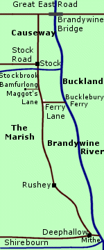
Causeway (Shire)Road through the Marish in the Shire. The Causeway ran south from the Great East Road along the west side of the Brandywine River. The Causeway began at the Brandywine Bridge and passed through Stock and Rushey and ended at Deephallow. The land in the Marish was marshy and the Causeway was a raised road with high banks.At the village of Stock, the Causeway was joined by the Stock Road from the west and traversed the Stockbrook. South of Stock, Maggot's Lane joined the Causeway from the west coming from Bamfurlong, the land of Farmer Maggot. About five miles further south, the Ferry Lane branched eastward from the Causeway to the Bucklebury Ferry. The entrance to the Ferry Lane was marked by two tall white posts. The Causeway continued south through the village of Rushey and on to Deephallow. From Deephallow, a lane ran from the Causeway to the Mithe Steps which led to a landing stage at the juncture of the Shirebourn and the Brandywine. A road also branched west off the Causeway from Deephallow to Willowbottom. On September 25, 3018 of the Third Age, Farmer Maggot brought Frodo Baggins, Sam Gamgee, and Pippin Took along the Causeway from Maggot's Lane to the Ferry Lane where they met Merry Brandybuck. Khamul the Easterling and another Nazgul searched along the Causeway for the Ring-bearer but the Hobbits crossed the Brandywine before Khamul could reach them. Names &
Etymology:
Sources:
|
Map
of the Causeway
 |
Out in the Westfold Vale, the Deeping-road joined the Great West Road which was the main road through Rohan. To the east, the Great West Road led to Edoras and on to Gondor. To the west, the Great West Road ran for about 15 miles to the Gap of Rohan where Isengard was located and then joined the North-South Road to Eriador.
After the Battle of Helm's Deep on March 3-4, 3019 of the Third Age, two burial mounds were raised alongside the Deeping-road before the Hornburg: one for the Men of the Westfold and one for the Men of the East Dales.
Names &
Etymology:
The Deeping-road was so called
because it was the road of Helm's Deep.
Sources:
The Two
Towers: "Helm's Deep," p. 135; "The Road to Isengard," p. 151, 154;
"The Palantir," p. 202
The Return
of the King: "The Passing of the Grey Company," p. 50
Unfinished
Tales: "The Battles of the Fords of Isen," p. 358, 363
The Lord
of the Rings: A Reader's Companion by Wayne G. Hammond and Christina
Scull: "Helm's Deep," p. 414; "The Road to Isengard," p. 421
"Nomenclature
of The Lord of the Rings," entry for Deeping Coomb
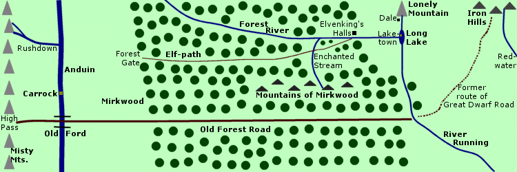
About halfway through Mirkwood, the Enchanted Stream flowed across the Elf-path. There was once a wooden bridge across the stream but it had rotted and the Elves used a boat to cross the stream instead. At its far eastern end, the Elf-path crossed the Forest River by way of a bridge and went up to the gates of the Elvenking's Halls.
In 2941 of the Third Age, Bilbo Baggins passed through the Forest Gate along with the Dwarves of Thorin & Company. They had been warned by Beorn and Gandalf to stay on the Elf-path and they did so for many days. They crossed the Enchanted Stream using the boat, though they had to retrieve it from the opposite bank. But they strayed from the Elf-path about a week later when they saw torchlight in the woods. They were attacked by Great Spiders and then imprisoned in the Elvenking's Halls until they managed to escape.
Sources:
The Hobbit:
Map of Wilderland; "Queer Lodgings," p. 143-48; "Flies and Spiders," p.
151-63
Merry Brandybuck met Frodo Baggins, Sam Gamgee, and Pippin Took at the Ferry Lane on September 25, 3018 of the Third Age.
Sources:
The Fellowship
of the Ring: "A Short Cut to Mushrooms," p. 106; "A Conspiracy Unmasked,"
p. 108
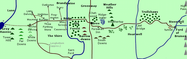
Great East Road |
Below:
Map
of the Great East Road
|
The western end of the Great East Road was at the Grey Havens on the Gulf of Lune. From there, the Road passed the Tower Hills and then entered the Shire. The Road traversed the entire width of the Shire from the White Downs to the Brandywine. The Three Farthing Stone stood on the roadside near the center of the Shire.
A number of smaller roads in the Shire connected with the Great East Road. The roads from Sarn Ford and Longbottom in the south and Little Delving in the north converged at Waymeet which was a town on the Great East Road. The Bywater Road connected Bywater and Hobbiton with the Great East Road. Travellers on the Great East Road sometimes stopped at the Green Dragon in Bywater. Roads also led north to Oatbarton and Scary. Frogmorton and Whitfurrows were two more towns on the Great East Road.
At the Brandywine River, the Causeway branched southward from the Road. The Great East Road crossed the Brandywine over the Bridge of Stonebows, also called the Brandywine Bridge. It continued for about 40 miles to Bree. This stretch of the Road was bordered by a line of trees that had been planted along it. The Road passed the north side of the Old Forest and the Barrow-downs and then curved southeastward to Bree.
Just outside Bree, the Great East Road intersected with the North-South Road, which was also called the Greenway. The North-South Road ran from Fornost in the north to the Gap of Rohan in the south, where it became the Great West Road to Minas Tirith.
Past the crossroads, the Great East Road went over a causeway spanning a deep trench to the West-gate of Bree. The Road passed through Bree and exited through the South-gate. These gates were closed at nightfall but there were gatekeepers on duty. The Prancing Pony in Bree was an important meeting place and rest stop for travellers on the Great East Road.
Outside the South-gate of Bree, the
Road curved back eastward around the foot of Bree-hill
and then sloped downward as it skirted the Chetwood.
Near the border of Bree-land,
the Forsaken Inn was on the Road
about a day's journey east of Bree. East of the Forsaken Inn, the Road
became more difficult for travellers.
The Road bent somewhat southward to avoid the Midgewater Marshes. It continued past Weathertop and then took a wide bend northward. Along this stretch the land north of the Road was flat and bare, while south of the Road there were thickets and dense patches of trees and bushes with wide barren spaces in between. Athelas could be found in the thickets south of the Road.
The Road crossed the River Hoarwell over the Last Bridge. On the other side of the bridge, the Road was bordered on the north by the wooded hills of the Trollshaws. The course of the Road wound back and forth and dipped up and down as it passed through this hilly region.
As the Road approached the Ford of Bruinen, it bent south and ran steadily downhill. Just before reaching the Ford, the Road entered a deep channel with high walls of red stone on either side. The last mile to the Ford was open and flat.
The Great East Road ended at the Ford of Bruinen. Across the Ford, path ran down into the hidden valley of Rivendell. There were also a number of paths up into the Misty Mountains beyond Rivendell. One such path led to the High Pass. On the other side of the High Pass, the Old Forest Road ran eastward through Mirkwood.
The Great East Road was a major thoroughfare of the North-kingdom of Arnor. When Arnor was divided into three Kingdoms in 861 of the Third Age, the Great East Road formed a boundary between Arthedain north of the Road and Cardolan to the south.
The land on either side of the Road between the Brandywine and the Far Downs was settled by the Hobbits in 1601 with the permission of King Argeleb II. The Hobbits were required to keep the Brandywine Bridge and the stretch of the Great East Road that ran through the Shire in repair.
After the fall of the North-kingdom in 1974, travel on the roads declined. By the end of the Third Age, there were some wanderers on the Road, but most of the travellers were Dwarves journeying to and from the Blue Mountains in western Eriador. The Dwarves paid little attention to the Hobbits as they passed through the Shire, but they did provide news to those who asked. The Hobbits sometimes travelled beyond their own stretch of the Great East Road as far as Bree.
When Frodo Baggins and his companions travelled to Rivendell in 3018, they used the Road as little as possible to avoid the Nazgul. They had to use the Road in order to enter and exit Bree and to cross the Last Bridge and for the final approach to the Ford of Bruinen. On October 20, five Nazgul came up the Great East Road behind them while four more came from the north. They pursued Frodo to the Ford but were washed away in a flood.
In early 3019, there was a fight in Bree instigated by Men who had come up the Greenway from the South. The ruffians were expelled but they still roamed the roads and travel became dangerous. A number of these Men also occupied the Shire. They erected gates on both ends of the Brandywine Bridge and no one was allowed to cross at night. The Men were defeated by the Hobbits in the Battle of Bywater on November 3.
Map
of the Great East Road:
(The exact course from the Grey
Havens to the White Downs is unknown.)
Names &
Etymology:
Also called the East-West Road,
the East Road, the Old Road, and the Great Road. (Note
that the North-South Road and the Great West Road combined were also referred
to as the Great Road.)
Sources:
The Hobbit:
:Roast
Mutton," p. 40-41, 53; "The Last Stage," p. 311-12
The Fellowship
of the Ring: "Prologue," p. 13, 17-18; "The Shadow of the Past," p.
52; "Three Is Company," p. 75, 80; "A Conspiracy Unmasked," p. 117; "The
Old Forest," p. 121, 124-25; "In the House of Tom Bombadil," p. 145; "Fog
on the Barrow-downs," p. 148-49, 158-59; "At the Sign of the Prancing Pony,"
p. 162-64; "Strider," p. 176, 184-86; "A Knife in the Dark," p. 192-95,
199-202; "Flight to the Ford," p. 210-14, 216, 220-27; "Many Meetings,"
p. 236, 243; "The Council of Elrond," p. 277, 280; "The Ring Goes South,"
p. 294
The Return
of the King: "Homeward Bound," p. 268, 271, 275-76; "The Scouring of
the Shire," p. 277, 279-80, 282, 294; "The Grey Havens," p. 311
Appendix
A of The Lord of the Rings: "Eriador, Arnor, and the Heirs of Isildur,"
p. 319; "The North-kingdom and the Dunedain," p. 320
Unfinished
Tales: "The Disaster of the Gladden Fields," p. 278 note 6; "The Quest
of Erebor," p. 332
The Lord
of the Rings: A Reader's Companion by Wayne G. Hammond and Christina
Scull: "The Shadow of the Past," p. 75; "A Knife in the Dark," p. 171
At its far eastern end, the Great West Road met the North-way which came from Minas Tirith through Forannest, the North-gate of the Rammas Echor. The Great West Road then curved around Amon Din and ran westward through Anorien. The Road skirted the edge of the Druadan Forest and passed the Beacon-hills of Gondor at the foot of the White Mountains.
The Great West Road ran through the edge of the Firien Wood to avoid the marshy land north of the forest. A path marked by a standing stone branched southward off the Road to Halifirien, the last of the Beacon-hills. At the western edge of the Firien Wood, the Great West Road crossed a bridge over the Mering Stream, which was the border between Gondor and Rohan.
In Rohan, the Great West Road passed through the Fenmarch and the regions of the Eastfold and the Folde. The Road traversed the Snowbourn by way of a ford near Edoras, and a track branched off to the city. Further on, the Deeping-road branched off into the Deeping-coomb where Helm's Deep was located.
The Great West Road then curved northwestward for a ways. About two miles before the Fords of Isen there was a sharp westward turn and the Road ran straight down to the riverbank. On the other side of the Isen, the North-South Road began. A branch road led north to Isengard.
In the early days of Gondor, the Great West Road and the North-South Road formed a single Royal Road between the two Kingdoms of the Dunedain. At that time, the region between the Mering Stream and the Fords of Isen was a province of Gondor called Calenardhon. In 2510 of the Third Age, that land became Rohan and the Rohirrim were responsible for maintaining the stretch of the Great West Road that ran through their land.
During the War of the Ring, an army from Mordor crossed the Anduin into Anorien and blocked the Great West Road. They dug trenches and erected stakes in the roadway with the purpose of preventing the Rohirrim from coming to Minas Tirith. But Ghan-buri-Ghan led the Rohirrim by a forgotten way through the Stonewain Valley and avoided the enemy forces. The Rohirrim arrived at dawn on March 15, 3019, and helped win the Battle of the Pelennor Fields.
Names &
Etymology:
Also referred to as the West
Road
as well as the horse-road and the
Horse-men's road.
The North-South Road and the Great West Road were collectively called the Royal Road or the Great Road. (Note that the Great East Road was also referred to as the Great Road.)
Sources:
The Two
Towers: "The King of the Golden Hall," p. 111; "Helm's Deep," p. 131,
133; "The Road to Isengard," p. 154-56; "The Palantir," p. 202, 205
The Return
of the King: "The Muster of Rohan," p. 74-75, 78; "The Siege of Gondor,"
p. 95; "The Ride of the Rohirrim," passim
Unfinished
Tales: "Cirion and Eorl," p. 300-302, 306, 314 note 32; "The Battles
of the Fords of Isen," p. 358, 363, 369-70
The Lord
of the Rings: A Reader's Companion by Wayne G. Hammond and Christina
Scull: "The Steward and the King," p. 635
Harad Road |
Map
of the Harad Road
|
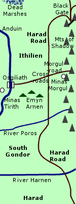 Road
from Harad through Ithilien
to the Black Gate of Mordor.
The Harad Road began in the far south of Middle-earth. It passed over the
River
Harnen into South Gondor and
then over the Crossing of Poros into Ithilien.
The road ran alongside the Mountains
of Shadow on the border of Mordor.
Road
from Harad through Ithilien
to the Black Gate of Mordor.
The Harad Road began in the far south of Middle-earth. It passed over the
River
Harnen into South Gondor and
then over the Crossing of Poros into Ithilien.
The road ran alongside the Mountains
of Shadow on the border of Mordor.
The Harad Road intersected with a road that ran eastward from Osgiliath. A circle of ancient trees surrounded the Cross-roads and there was a statue of a King seated on a throne. The road from Osgiliath led to the stronghold of Gondor called Minas Ithil which was captured by the Nazgul in 2002 and became Minas Morgul. The Osgiliath Road was afterwards known as the Morgul-road. Orcs defiled the statue of the King and replaced its head with a stone bearing the Red Eye of Sauron.
Past the Cross-roads of the Fallen King, the Harad Road continued northward through Ithilien for about 100 miles to the Black Gate. The road was straight and level. It passed over streams by way of arched stone bridges. At one point the road passed through a ravine with steep sides.
As it came to the end of the Mountains of Shadow, the road curved sharply around Narchost - the westernmost of the Towers of the Teeth - to the entrance of Mordor. Two other roads converged with the Harad Road at the Black Gate. One ran eastward alongside the Ash Mountains for about 50 miles. The other ran northward across Dagorlad.
The Harad Road was built in the early days of Gondor. Ithilien, which the road traversed, was an important region of Gondor. For a time, Gondor held the territory known as South Gondor between Ithilien and the Harnen but this region was later contested with the Haradrim. The road gradually fell into disuse and became overgrown in places.
At the end of the Third Age, Sauron's minions repaired the 30-mile section of road closest to the Black Gate. Sauron used the Harad Road to bring armies to Mordor from the south. On March 7, 3019, Faramir and the Rangers of Ithilien ambushed an army of Haradrim at the point where the Harad Road passed through the steep-sided ravine.
Frodo Baggins and Sam Gamgee passed along the road through the ravine earlier that day. For the rest of their journey through Ithilien, the Hobbits kept west of the Harad Road until they came to the Cross-roads and followed the Morgul-road to the Morgul Vale.
The Host of the West set out north on the Harad Road on March 18. At the Black Gate on March 25, they fought Sauron's forces in the Battle of the Morannon.
Names &
Etymology:
Also called the Southward Road
and the North Road.
Sources:
The Two
Towers: "The Black Gate Is Closed," p. 247, 249, 254; "Of Herbs and
Stewed Rabbit," p. 256-59, 267-69; "The Window on the West," p. 277; "The
Forbidden Pool," p. 300-301; "Journey to the Cross-roads," p. 303, 310-11
The Return
of the King: "The Black Gate Opens," p. 159-63
Unfinished
Tales: "Cirion and Eorl," p. 294, 312 note 15
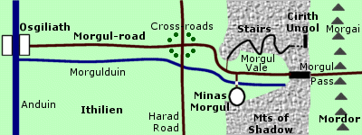
The Morgul-road ran from west to east across Ithilien. It intersected with the Harad Road which ran southward from the Black Gate to Harad. At the Cross-roads of the Morgul-road and the Harad Road there was a ring of ancient trees and a statue of a King seated on a throne.
The Morgulduin flowed along the south side of the Morgul-road from the Morgul Vale to the Anduin. At the mouth of the Morgul Vale, the road bent southwards around a spur of rock and then turned eastward into the valley. Within the valley, the Morgul-road gleamed with a pale, sickly light like Minas Morgul.
Near Minas Morgul, the road diverged. A path ran to the north side of the valley where the Stairs of Cirith Ungol climbed to the Pass of Cirith Ungol. The main road branched in two at the head of a bridge spanning the Morgulduin. One branch crossed the bridge and climbed to Minas Morgul. The other continued eastward through the valley to the Morgul Pass over the Mountains of Shadow. The road then spanned another bridge over a ravine between the Mountains of Shadow and the Morgai and descended into Mordor, joining a network of roads across Gorgoroth.
Gollum led Frodo Baggins and Sam Gamgee to the Morgul-road on March 9, 3019 of the Third Age. The next day on March 10 they came to the Cross-roads. They took the Morgul-road eastward to the Morgul Vale and then took the path to the Stairs of Cirith Ungol. At the same time, the Lord of the Nazgul led an army from Minas Morgul down the Morgul-road toward Osgiliath.
Map of the Morgul-road:
Names &
Etymology:
The Morgul-road was so called
because it came from Minas Morgul and the Morgul Vale. The word morgul
means
"black magic" from mor meaning "black, dark" and gûl
meaning
"sorcery, magic" from the stem ngol or nólë meaning
"long study, lore, knowledge." It was also called the Osgiliath Road
after the city on its western end. The section of the road from Minas Morgul
to the Morgul Pass was referred to as the Wraith-road.
Sources:
The Two
Towers: "Journey to the Cross-roads," p. 306-311; "The Stairs of Cirith
Ungol," p. 312-16, 319
The Return
of the King: "The Land of Shadow," p. 193, 197
Appendix
B of The Lord of the Rings: "The Tale of Years," p. 374
The History
of Middle-earth, vol. VIII, The War of the Ring: "Journey to the Cross-roads,"
p. 175-78, 181-82; "Kirith Ungol," p. 195, 222 note 22; "Minas Tirith,"
p. 291, 294-95; "The Siege of Gondor," p. 327
North-South Road (Greenway) |
Map
of the North-South Road
|
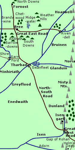 Part
of the Royal Road linking Arnor and Gondor.
The North-South Road was approximately 600 miles long. It ran between Fornost
in the north and Isengard in the south. At
the Fords of Isen the North-South Road merged
with the Great West Road.
Part
of the Royal Road linking Arnor and Gondor.
The North-South Road was approximately 600 miles long. It ran between Fornost
in the north and Isengard in the south. At
the Fords of Isen the North-South Road merged
with the Great West Road.
The northern half of the North-South Road was in Eriador. From Fornost, the Road ran south to Bree. Outside the West-gate of Bree, the North-South Road intersected with the Great East Road. At this major crossroads was the inn called the Prancing Pony, where travellers brought news from the South as well as goods such as pipe-weed which first came to Bree and the Shire via the North-South Road.
The North-South Road then passed through the narrow passage called the Andrath between the Barrow-downs and the South Downs. South of the Andrath, a road to the Shire branched off the North-South Road. The North-South Road then curved southeastward through the region of Minhiriath.
At the city of Tharbad, the Road crossed the River Greyflood on the southern border of Eriador. Originally the Road went over the Bridge of Tharbad. On either side of the Bridge, the Road was built up on causeways to traverse the surrounding marshland. But the Bridge was destroyed by floods in 2912 of the Third Age and all that remained was a dangerous ford.
The southern half of the North-South Road passed through Enedwaith, which at one time nominally belonged to Gondor but was essentially a borderland between Gondor and Arnor. East of the Road in Enedwaith was Dunland at the foot of the Misty Mountains.
At the southern end of the Misty Mountains, the North-South Road curved eastward through the Gap of Rohan and ended at the Fords of Isen. Just west of the Fords a road branched north to Isengard. East of the Fords was the Great West Road to Minas Tirith and Osgiliath.
Together the North-South Road and the Great West Road formed the Royal Road, or Great Road, which was the main route by land between Gondor and Arnor. The two Kingdoms were founded in 3320 of the Second Age. Each was responsible for maintaining their own stretch of the Road, and together they built and maintained the Bridge of Tharbad and its causeways.
After the Great Plague in 1636 of the Third Age, Gondor and Arnor were considerably weakened and could no longer keep the Road and Bridge in repair. The North-kingdom fell in 1974 and Fornost at the northern end of the North-South Road was abandoned. The causeways near Tharbad eventually disintegrated and the marshes encroached on the Road. In the spring of 2912 after the Fell Winter, floods caused the Bridge to collapse.
Fewer and fewer travellers used the North-South Road and it became overgrown with grass so that the people of Bree called it the Greenway. However, during the War of the Ring at the end of the Third Age, unwelcome travellers began to come up the North-South Road from the South. Some were honest refugees, but many were troublemakers including agents of Saruman. Early in 3019, there was fighting in Bree and the Shire was taken over by Saruman's agents.
The Hobbits expelled the Men from the Shire in the Battle of Bywater on November 3, and the Rangers of the North returned from the war and dealt with the other troublemakers. The North-kingdom was reestablished by Aragorn, King Elessar, and the North-South Road was open to travellers once more.
Names &
Etymology:
The North-South Road was
called the Greenway in later years by the Bree-folk because it had
become disused and overgrown with grass. It was sometimes called the North
Road and the Old South Road.
The North-South Road and the Great West Road were collectively called the Royal Road or the Great Road. (Note that the Great East Road was also referred to as the Great Road.)
Sources:
The Fellowship
of the Ring: "Prologue - Concerning Pipe-weed," p. 18; "At the Sign
of the Prancing Pony," p. 162-63, 165, 167-68; "Strider," p. 176; "The
Council of Elrond," p. 269, 276; "The Ring Goes South," p. 287
The Return
of the King: "Homeward Bound," p. 271-73; "The Scouring of the Shire,"
p. 284
Unfinished
Tales: "The History of Galadriel and Celeborn," p. 264-65; "The Disaster
of the Gladden Fields," p. 271, 278 note 6; "The Hunt for the Rings," p.
348; "The Battles of the Fords of Isen," p. 369-70
The Lord
of the Rings: A Reader's Companion by Wayne G. Hammond and Christina
Scull: "Prologue," p. 31
Sources:
The Return
of the King: "The Steward and the King," p. 248
The Lord
of the Rings: A Reader's Companion by Wayne G. Hammond and Christina
Scull: "The Ride of the Rohirrim," p. 559; "The Steward and the King,"
p. 635
Old Forest Road |
Below:
Map
of the Old Forest Road
|
The Old Forest Road traversed Mirkwood to the River Running on the eastern side of the forest. The Road was about 300 miles long from the High Pass to the River Running. Originally the Road extended a further 200 miles northeastward to the Iron Hills but that section of the Road had fallen into disuse by the end of the Third Age.
The Old Forest Road was made by the Dwarves sometime before 600 of the Second Age, possibly as early as the First Age. It was then called the Great Dwarf Road. The Dwarves used the Road to travel between their mines in the Iron Hills and the Misty Mountains, where Khazad-dum was located.
But after the Dwarves of Khazad-dum helped the Elves during the War of the Elves and Sauron in 1697, Sauron sent Orcs to the Misty Mountains to harrass the Dwarves. Travel between Khazad-dum and the Iron Hills ceased for a time. The Dwarves lost Khazad-dum in 1980 of the Third Age.
Around 1000 of the Third Age, Sauron had come to live in Dol Guldur in the southern part of the forest. His influence extended northward as far as the Road and a shadow fell over the entire forest.
By the end of the Third Age, the Old Forest Road had become overgrown, especially in the eastern part of Mirkwood where the Road deteriorated into an impassable marsh. Orcs often used the Old Forest Road. Beorn advised Bilbo Baggins and the Dwarves to avoid the Old Forest Road and use the Elf-pathfarther north in Mirkwood instead.
Beorn's people, the Beornings, kept
the High Pass open for travellers as the War
of the Ring began. After the War, the shadow was lifted from Mirkwood.
The Beornings and the Woodmen were given the middle section of the forest
where the Old Forest Road was located. It seems likely that they repaired
the Old Forest Road so travellers could use it once more.
Names &
Etymology:
Also called the Forest Road.
Originally called the Great Dwarf Road or the Dwarf-road.
The Sindarin translation was Men-i-Naugrim from men meaning
"way" and
Naugrim meaning "Dwarves."
Sources:
The Hobbit:
"Queer
Lodgings," p. 144-45
The Fellowship
of the Ring: "Many Meetings," p. 241
Appendix
B of The Lord of the Rings: "The Tale of Years," p. 375
Unfinished
Tales: "The Disaster of the Gladden Fields," p. 280-81 note 14; "The
Hunt for the Ring," p. 344
The Silmarillion:
"Appendix - Elements in Quenya and Sindarin Names," entries for men
and naug
The History
of Middle-earth, vol. XII, The Peoples of Middle-earth: "Of Dwarves
and Men," p. 302, 305, 323-24 note 30
On March 15, 3019 of the Third Age, the Steward Denethor II brought his son Faramir to the Silent Street and tried to burn him alive in the House of the Stewards. Pippin Took followed the procession to the Silent Street and went to seek help from Beregond and Gandalf. Faramir was saved from the pyre but Denethor perished.
In the year 120 of the Fourth Age, Aragorn, King Elessar, went to the Silent Street accompanied by his family when he was prepared to die.
Names &
Etymology:
The Sindarin name Rath Dínen
translates as "silent street." The word rath is derived from a stem
meaning "climb." It was used for streets in a city, particularly streets
on an incline like those in the seven-tiered City of Minas Tirith. The
word dínen is from tínen meaning "silent."
Also called the Street of Tombs.
Sources:
The Return
of the King: "The Siege of Gondor," p. 100-101; "The Pyre of Denethor,"
p. 127-31
Appendix
A of The Lord of the Rings: "The Tale of Aragorn and Arwen," p. 343-44
The Silmarillion:"Appendix
- Elements in Quenya and Sindarin Names," entry for din
Unfinished
Tales: "The History of Galadriel and Celeborn," p. 255 note 16 (rath)
The Lord
of the Rings: A Reader's Companion by Wayne G. Hammond and Christina
Scull: "The Siege of Gondor," p. 550-51
Pippin Took met Bergil at the Old Guesthouse on the Lampwrights' Street on March 9, 3019 of the Third Age, and they went together to the Great Gate to watch the troops arriving.
Names &
Etymology:
The Lampwrights' Street was
apparently home to lampwrights, or lamp makers. The Sindarin name was Rath
Celerdain. The word celerdain is the plural of calardan
meaning "lampwright." The word calar means "portable lamp." The
word rath is derived from a stem meaning "climb." It was used for
streets in a city, particularly streets on an incline like those in the
seven-tiered City of Minas Tirith.
Sources:
The Return
of the King: "Minas Tirith," p. 41-42
Unfinished
Tales: "The History of Galadriel and Celeborn," p. 255 note 16 (rath)
The Lord
of the Rings: A Reader's Companion by Wayne G. Hammond and Christina
Scull: "Minas Tirith," p. 523; "The Siege of Gondor," p. 551
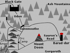
Sauron's RoadRoad from Barad-dur to Mount Doom in Mordor. Sauron's Road began at the great western gate of Barad-dur. It spanned a deep abyss by way of a long iron bridge and then ran westward for a league (3 miles) across Gorgoroth. On either side of the road there were smoking chasms.At the foot of Mount Doom, Sauron's Road climbed a long causeway up the eastern slopes. The road then wound upwards around the mountain, turning first south then west then north and back to the east. The road encircled the base of the mountain, which was 3,000 feet high, and then ran partway up the cone, which rose another 1,500 feet. It ended at the door to the Chambers of Fire on the east side of Mount Doom facing the Window of the Eye in Barad-dur. Sauron's Road was a broad path paved with ash and broken rubble. The road was frequently blocked or damaged by the volcanic eruptions of Mount Doom and it was cleared and repaired by Orcs. On March 25, 3019 of the Third Age, Sam Gamgee carried Frodo Baggins up the northern slopes of Mount Doom until he found Sauron's Road leading to their destination. "'Why, it might have been put there a-purpose!' he said to himself. 'If it wasn't there, I'd have to say I was beaten in the end.'" (RotK, p. 219) Sources:
|
Map
of Sauron's Road
 |
Source:
The Return
of the King: "The Scouring of the Shire," p. 286
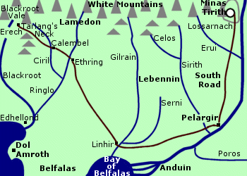
South RoadRoad in southern Gondor. The South Road began at the Great Gate of Minas Tirith. It ran southward across the Pelennor Fields and passed through a gate in the Rammas Echor. The road was broad and paved and there was a riding track along its eastern edge.The South Road led to the mountain villages of Tumladen and Lossarnach. It then traversed the Crossings of Erui and continued through Lebennin to Pelargir, a port city on the Anduin. The distance between Minas Tirith and Pelargir was 42 leagues (126 miles). From Pelargir, a road continued through southern Gondor. It is not clear whether this road was considered part of the South Road. This road ran west to Linhir near the juncture of the Gilrain and Serni and then turned north to Ethring on the Ringlo. The road bent westward to Calembel on the Ciril and on through Tarlang's Neck and ended at Erech at the mouth of the Blackroot Vale. During the War of the Ring at the end of the Third Age, the women, children, and elderly of Minas Tirith were evacuated down the South Road. On March 9, 3019, nearly 3,000 troops from the southern provinces came up the South Road to help defend Minas Tirith in the Battle of the Pelennor Fields. After the battle, about 4,000 more troops led by Angbor came up the South Road on or around March 18. Sources:
|
Map
of the South Road
|
East of Tuckborough, the Stock Road rolled up and down as it skirted the Green Hill Country. The road then flattened out and ran through the northern edge of the Woody End. A lane branched off the Stock Road to Woodhall. The Stock Road then curved north and east through the lowlands of the Yale. At Stock, it met the Causeway which ran south from the Brandywine Bridge.
Frodo Baggins, Sam Gamgee, and Pippin Took travelled along the Stock Road as they began their journey in September 3018 of the Third Age. On September 24, Khamul pursued the Hobbits down the Stock Road. The Hobbits hid from the Nazgul until he passed. They turned off the main road down the lane leading to Woodhall. Khamul almost caught the Hobbits again at dusk but he fled as a company of Elves led by Gildor Inglorion came down the lane.
After the War of the Ring in September of 3021, Frodo and Sam took the Stock Road to the Woody End. There they met Elrond, Galadriel, and other Elves and together they went to the Grey Havens.
Sources:
The Fellowship
of the Ring: Map of "A Part of the Shire"; "Three Is Company," p. 80-90;
"A Short Cut to Mushrooms," p. 97
The Return
of the King: "The Grey Havens," p. 307
The Lord
of the Rings: A Reader's Companion by Wayne G. Hammond and Christina
Scull: "A Short Cut to Mushrooms," p. 112
All entries are Copyright © by the Thain from former tuckborough.net. Please contact me if you are Thain or know anything about how to contact the original author.
2003-2011, The Thain's Book - thainsbook.minastirith.cz
- e-mail: thain at tuckborough.net