
An encyclopedia of Middle-earth and Numenor
|
|
|
|
|
|
|
|
|
|
|
|
|
|
| |
|
|
An encyclopedia of Middle-earth and Numenor |
|

At their western end, the Ash Mountains met the Mountains of Shadow. Between the two ranges was Cirith Gorgor, the Haunted Pass, which was barred by the great Black Gate. The Towers of the Teeth stood on hills on either side of the Black Gate. Inside the Black Gate was the enclosed valley of Udun, and at the other end of the valley was the pass called the Isenmouthe.
During Sauron's absence from Mordor in the early part of the Third Age, the Men of Gondor began to build a road running eastward along the Ash Mountains outside Mordor. They only completed the first 50 miles of the road, and it soon fell into disrepair.
When the Wainriders from Rhun attacked Gondor in 1944 of the Third Age, they used the road to approach the Black Gate undetected in the shadow of the Ash Mountains. They took Gondor's Northern Army by surprise and defeated them, and King Ondoher of Gondor was killed. The Wainriders were later defeated in the Battle of the Camp by Earnil and the Southern Army of Gondor.
At the Battle of the Morannon on March 25, 3019, an army of Easterlings awaited in the shadows of the Ash Mountains until they received the signal to attack. That battle ended when the One Ring was destroyed and Sauron was vanquished.
Names &
Etymology:
Also called the Ashen Mountains.
The Ash Mountains were called Ered Lithui in Sindarin. The word
ered
means "mountains" and lithui means "ashen." They were so called
because of their ash-grey color.
Sources:
The Two
Towers: "The Black Gate Is Closed," p. 244-45, 247
The Return
of the King: "The Black Gate Opens," p. 167; "The Land of Shadow,"
p. 205
Unfinished
Tales: "Cirion and Eorl," p. 292, 312 note 15
The Silmarillion:
"Appendix - Elements in Quenya and Sindarin Names," entries for lith
and orod
Blue Mountains |
Top:
Blue Mountains before the end of the First Age
Bottom: Blue Mountains in the Second & Third Ages |
 Mountain
range in northwestern Middle-earth. The Blue Mountains were on the western
border of Eriador. The geography of the Blue
Mountains changed during the War of Wrath
at the end of the First Age. Originally, the large region of Beleriand
was located west of the Blue Mountains. But afterwards all that remained
was a much smaller region called
Lindon.
Mountain
range in northwestern Middle-earth. The Blue Mountains were on the western
border of Eriador. The geography of the Blue
Mountains changed during the War of Wrath
at the end of the First Age. Originally, the large region of Beleriand
was located west of the Blue Mountains. But afterwards all that remained
was a much smaller region called
Lindon.
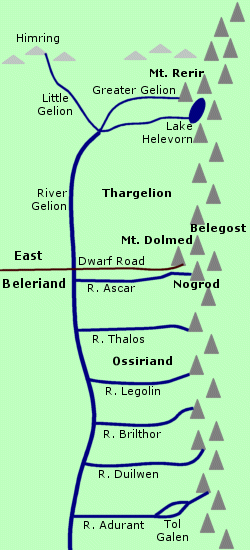
Originally, seven rivers flowed from the western side of the Blue Mountains. The northernmost river was the Gelion. The Greater Gelion sprang from under Mount Rerir in the northern Blue Mountains. It was joined by a stream from Lake Helevorn, which was located in a valley at the foot of Mount Rerir. The Greater Gelion then merged with the Little Gelion from Himring to the west and formed the Gelion. The Gelion flowed southward parallel with the Blue Mountains.
Six rivers flowed westward from the Blue Mountains into the Gelion. From north to south they were the Ascar, the Thalos, the Legolin, the Brilthor, the Duilwen, and the Adurant. This region was called Ossiriand, the Land of Seven Rivers. North of the Ascar between the Gelion and the Blue Mountains was the region called Thargelion, "the Land beyond Gelion."
Around the year 1125 of the Years of the Trees - before the beginning of the First Age - Elves crossed the Blue Mountains into Beleriand. Some settled in Beleriand while others continued the Great Journey across the Sea to the Undying Lands. Around 1350, another group of Elves called the Nandor crossed the Blue Mountains and settled in Ossiriand. They became known as the Green-elves. The Green-elves were known for their singing, and Ossiriand was sometimes called Lindon, "the Land of Music."
The Blue Mountains were inhabited by Dwarves. According to Dwarf legend, two of the Seven Fathers of the Dwaves - those of the Firebeards and Broadbeams - had awakened beneath the Blue Mountains. The Dwarves of the Blue Mountains had two cities called Nogrod and Belegost. These cities were near the great peak of Mount Dolmed, around the midpoint of the Blue Mountains.
Around 1250 of the Years of the Trees, the Dwarves of Nogrod and Belegost came into Beleriand and encountered the Elves. The two peoples traded with one another and the Dwarves built a road that came down from a pass over the mountains past Mount Dolmed and along the Ascar to the Gelion. The Dwarves were renowned for their craftsmanship. The smiths of Belegost created a mail of linked rings and the smiths of Nogrod - including Telchar who made Narsil - excelled at making arms.
At the beginning of the First Age, a group of Elves returned to Beleriand from the Undying Lands. These Elves of the Noldor were led by Feanor, who wanted to retrieve the Silmarils stolen by Morgoth. Feanor's fourth son Caranthir settled on the shores of Lake Helevorn and built a fortress on the western slopes of Mount Rerir. Caranthir's people met the Dwarves of the Blue Mountains and made a trade alliance with them.
The Dwarves of the Blue Mountains were befriended by an Elf named Eol, who frequently visited Nogrod and Belegost. He learned much about metalwork from the Dwarves and devised a strong, black metal called galvorn.
Men came over the Blue Mountains into Beleriand starting around 310 of the First Age. The first group led by Beor initially settled in the foothills of the Blue Mountains in Ossiriand and were found by Finrod Felagund. The Green-elves of Ossiriand did not want the Men there because they hunted and cut down trees so Finrod led them across the Gelion.
Another group of Men called the Haladin first settled on the eastern slopes of the Blue Mountains before they crossed into Ossiriand. The Green-elves were unfriendly to them so they moved north to Thargelion. The Haladin lived there until around 375, when a troop of Orcs came over the mountain pass near Mount Dolmed and besieged them. Then the Haladin moved westward led by Haleth. A third group of Men led by Marach also crossed the Blue Mountains but continued westward down the Dwarf-road.
During the Battle of Sudden Flame in 455, Orcs captured Caranthir's fortress on the slopes of Mount Rerir. They defiled Lake Helevorn and ravaged the region of Thargelion.
In 502, Dwarves from Nogrod were asked by King Thingol of Doriath to set one of the Silmarils in the Nauglamir - which was a necklace that the Dwarves had originally made for Finrod. The Dwarves coveted both the necklace and the Silmaril and they killed Thingol. The Dwarves were pursued by the Elves and only two escaped and returned to Nogrod.
The two Dwarves claimed Thingol had cheated them and that their comrades had been killed on Thingol's orders. The Dwarves of Belegost tried to dissuade the Dwarves of Nogrod from seeking revenge but they did not listen. In 503, the Dwarves of Nogrod defeated the Elves of Doriath, but on the way home the Dwarves were attacked by Beren and the Green-elves of Ossiriand. Some Dwarves escaped, but on the slopes of Mount Dolmed they encountered Ents who drove them into the woods of the Blue Mountains and the Dwarves were never seen again.
Morgoth was defeated in War of Wrath from 545 to 587. During the war, Beleriand was ruined and much of the land sank beneath the Sea. The small area of land that remained had once been part of Ossiriand and was called by its alternate name, Lindon. The hill of Himring, which had been west of the Blue Mountains, remained above water as the island of Himling.
The Blue Mountains were split by the Gulf of Lune that opened onto the Sea. A short stretch of the Blue Mountains about 150 miles long was south of the Gulf. These mountains had wooded slopes on both sides. An outlier ran eastward from about the midpoint of the range.
North of the Gulf of Lune, the Blue Mountains stretched about 350 miles. At their northern end, the mountains curved eastward to the Icebay of Forochel. The western slopes were wooded. One river began on the western side of the mountains and curved south to the Gulf of Lune. The River Lune and the Little Lune began on the eastern side of the Blue Mountains and merged before flowing into the Gulf.
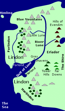 Elves
continued to live in Lindon west of the Blue Mountains. In the year 1 of
the Second Age, they established the Grey
Havens on the Gulf of Lune.
Cirdan the Shipwright
was the Lord of the Havens and Elves came there from time to time to sail
to the Undying Lands.
Elves
continued to live in Lindon west of the Blue Mountains. In the year 1 of
the Second Age, they established the Grey
Havens on the Gulf of Lune.
Cirdan the Shipwright
was the Lord of the Havens and Elves came there from time to time to sail
to the Undying Lands.
The Dwarf-realms of Nogrod and Belegost had been destroyed when the mountains had split apart. Many Dwarves of the Blue Mountains moved to Khazad-dum in the Misty Mountains. But some Dwarves remained on the eastern side of the Blue Mountains, particularly in the stretch of mountains south of the Gulf of Lune and in the mountains north of the Little Lune.
In 1974 of the Third Age, King Arvedui of Arthedain in the North-kingdom of Arnor hid in the old Dwarf-mines in the northern Blue Mountains. He had fled from an invasion by the Witch-king of Angmar. Arvedui later tried to escape by ship on the Icebay of Forochel but was drowned.
In 2802, after the Battle of Azanulbizar, Thrain and Thorin settled in the southern branch of the Blue Mountains. They had a small following including Balin and Gloin but others joined them and their numbers gradually increased. Thrain's daughter Dis gave birth to Fili in 2859 and Kili in 2864. Gloin's son Gimli was born in the Blue Mountains in 2879.
The Dwarves of the Blue Mountains at this time worked mainly in iron. They did not have gold and riches but they had enough to live comfortably and they made fair halls beneath the mountains. But both Thrain and Thorin remembered the treasures they had left behind in the Lonely Mountain and wanted to return there. Thrain set out for the Lonely Mountain in 2841 but perished in Sauron's dungeons in Dol Guldur.
In 2941, Thorin met Gandalf in Bree and invited him to the Blue Mountains. There they planned a quest to retake the Lonely Mountain from Smaug the Dragon. The quest was successful and afterwards many Dwarves relocated to the Lonely Mountain. However some Dwarves remained in the Blue Mountains. They travelled to and from their home via the Great East Road through the Shire and the Hobbits obtained news and metal goods from them.
In the days leading up to the War of the Ring at the end of the Third Age, many Dwarves sought refuge in the Blue Mountains which were far from the area of Sauron's influence. After the War, Dwarves continued to live in the Blue Mountains into the Fourth Age.
Names &
Etymology:
The Blue Mountains were so named
because they appeared blue from a distance. The Sindarin name for the Blue
Mountains was Ered Luin from ered meaning "mountains" and
luin
meaning "blue."
The Blue Mountains were also called Ered Lindon after the region of Lindon, "the Land of Music," as well as the Mountains of Lune and the Western Mountains.
Sources:
The Fellowship
of the Ring: "Prologue," p. 13; "The Shadow of the Past," p. 52
The Two
Towers: "Treebeard," p. 72
Appendix
A of The Lord of the Rings: "Eriador, Arnor and the Heirs of Isildur,"
p. 319; "The North-kingdom and the Dunedain," p. 321; "Durin's Folk," p.
352, 357
Appendix
B of The Lord of the Rings: "The Tale of Years," p. 363-64, 369
The Silmarillion:
"Of the Coming of the Elves," p. 54; "Of the Sindar," p. 91-92, 94; "Of
the Return of the Noldor," p. 112-14; "Of Beleriand and Its Realms," p.
123-24; "Of Maeglin," p. 133-34; "Of the Coming of Men into the West,"
p. 140-43, 145; "Of the Ruin of Beleriand," p. 153: "Of the Fifth Battle,"
p. 193; "Of the Ruin of Doriath," p. 232-235; "Of the Rings of Power and
the Third Age," p. 285-86, 289-90; "Appendix - Elements in Quenya and Sindarin
Names," entries for luin and orod
Unfinished
Tales: "Aldarion and Erendis," p. 174, 213; "The History of Galadriel
and Celeborn," p. 235; "The Quest of Erebor," p. 322, 328-29, 332, 336
The History
of Middle-earth, vol. X, Morgoth's Ring: "The Annals of Aman," p. 83,
93; "Athrabeth Finrod Ah Andreth," p. 307
The History
of Middle-earth, vol. XI, The War of the Jewels: "The Grey Annals,"
p. 34, 45-46; "The Later Quenta Silmarillion," p. 215-17, 221-22, 226-27
The History
of Middle-earth, vol. XII, The Peoples of Middle-earth: "The Making
of Appendix A," p. 281-82; Of Dwarves and Men," p. 301, 313, 322 note 24
The Letters
of J.R.R. Tolkien: Letter #154
Names &
Etymology:
Cloudyhead was called Bundushathur
or Shathur by the Dwarves and Fanuidhol the Grey by the Elves.
The Elvish name Fanuidhol translates as "Cloudyhead" in the Common Speech, from fána meaning "cloud" and dôl meaning "head." It is likely that the Dwarvish name Bundushathûr also means "Cloudyhead." The element bund probably means "head"; u may mean "of" or "in"; and shathûr probably means "clouds."
Sources:
The Fellowship
of the Ring: "The Ring Goes South," p. 296; "Lothlorien," p. 347
The Return
of the King: "Many Partings," p. 263
The History
of Middle-earth, vol. V, The Lost Road and Other Writings: "The Etymologies,"
entries for NDOL and SPAN
The History
of Middle-earth, vol. VII, The Treason of Isengard: "The Ring Goes
South," p. 174 footnote 21 (translation of Bundushathur)
Dol Tarlang, Cûl Veleg & Cûl Bîn |
Map
of Tarlang's Neck and the spur
|
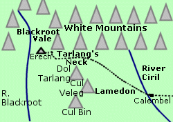 Mountains
of the White Mountains. Dol Tarlang, Cul Veleg, and
Cul Bin were three mountains that formed a spur on the southern side of
the White Mountains between the Blackroot Vale
and Lamedon. The spur was separated from
the main range by the pass called Tarlang's
Neck. Dol Tarlang was the northernmost mountain in the spur, Cul Veleg
was in the middle, and Cul Bin was at the southern end.
Mountains
of the White Mountains. Dol Tarlang, Cul Veleg, and
Cul Bin were three mountains that formed a spur on the southern side of
the White Mountains between the Blackroot Vale
and Lamedon. The spur was separated from
the main range by the pass called Tarlang's
Neck. Dol Tarlang was the northernmost mountain in the spur, Cul Veleg
was in the middle, and Cul Bin was at the southern end.
According to local legend, the three mountains and the pass were formed when a Giant named Tarlang tripped while carrying a load of rocks on his head to build the White Mountains. Dol Tarlang was the Giant's head, Cul Veleg was a large load of rocks, and Cul Bin was a smaller load of rocks. The pass went through his broken neck.
Note:
This local legend appears to be
a "Tall Tale" rather than an actual historical event, though in Middle-earth
one can never be certain!
Names &
Etymology:
The name Dol Tarlang means
"Tarlang's Head." The word dol means "head." Tarlang, the
Giant's name, means "stiff-necked."
The name Cûl Veleg means "big load." The word cûl means "load" and veleg is from beleg meaning "great, mighty."
The name Cûl Bîn means "little load." The word bîn is from pîn meaning "small."
Source:
The Lord
of the Rings: A Reader's Companion by Wayne G. Hammond and Christina
Scull: "The Passing of the Grey Company," p. 536-37
The Dwimorberg was located in the White Mountains on the eastern side of the valley of Harrowdale. The mountain called Irensaga was on the north side of the Dwimorberg, and the Starkhorn was on the south side. The refuge of Dunharrow was high on the slopes of these mountains.
A road lined with standing stones led through Dunharrow to the dark wood called the Dimholt at the base of the Dwimorberg. There was an opening at the root of the Dwimorberg marked by a single standing stone. In the glen beyond was a sheer wall of rock in which was the Dark Door. Strange signs and figures were carved around the Dark Door and fear flowed from it. The Paths of the Dead led from the Dark Door under the Dwimorberg and then on to the Blackroot Vale on the other side of the White Mountains in Gondor.
The Dead who inhabited the Paths of the Dead under the Dwimorberg were originally Men of the White Mountains who were cursed by Isildur for breaking their oath to fight Sauron at the end of the Second Age. At the end of the Third Age, Aragorn and the Grey Company came to the Dwimorberg to enter the Paths of the Dead and summon the Dead to fulfill their oath.
Names &
Etymology:
Also called the Haunted Mountain.
Dwimorberg means "Haunted Mountain" from the Old English dwimor meaning "phantom, ghost, illusion, delusion, apparition" and berg meaning "mountain."
Sources:
The Return
of the King: "The Passing of the Grey Company," p. 59; "The Muster
of Rohan," p. 68-70
Old English
Ered Lómin |
Map
of the Ered Lomin
(Northern border of Hithlum is speculative.) |
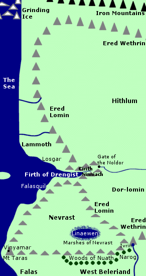 Mountain
range on the western border of Hithlum. The
Ered Lomin were located on the western shore of Middle-earth. At their
southern end, the Ered Lomin joined the Ered Wethrin, which formed the
southern and eastern borders of Hithlum. The Ered Wethrin may have curved
around to join the Ered Lomin in the north as well, thereby enclosing Hithlum.
Mountain
range on the western border of Hithlum. The
Ered Lomin were located on the western shore of Middle-earth. At their
southern end, the Ered Lomin joined the Ered Wethrin, which formed the
southern and eastern borders of Hithlum. The Ered Wethrin may have curved
around to join the Ered Lomin in the north as well, thereby enclosing Hithlum.
The Ered Lomin were divided by the Firth of Drengist which narrowed to form a ravine called Cirith Ninniach, the Rainbow Cleft. From there, a tunnel ran under the Ered Lomin and emerged on the other side through Annon-in-Gelydh, the Gate of the Noldor. A river ran through the tunnel and emptied into the Firth.
On the east side of the Ered Lomin, the plains of Hithlum lay north of the Firth, while south of the Firth was the region of Dor-lomin. West of the Ered Lomin, there was a stretch of coast between the mountains and the Sea. The area called Lammoth was on the coast north of the Firth.
South of the Firth of Drengist, the Ered Lomin curved inland to meet the Ered Wethrin. The region of Nevrast was on the coast west of the Ered Lomin.
The Ered Lomin were created by the upheaval resulting from the Battle of the Powers between the Valar and Morgoth between 1090 and 1099 of the Years of the Trees. The Ered Wethrin were formed at this time as well.
In 1495, Morgoth returned to Middle-earth after stealing the Silmarils. He was followed by Ungoliant, an evil being in spider form who wanted to devour the Silmarils. They crossed the Grinding Ice and then came down the coast to the land north of the Firth of Drengist. Ungoliant cast a web around Morgoth and he gave a terrible, echoing cry.
Afterwards the region was called Lammoth, the Great Echo, and the mountains were named Ered Lomin, the Echoing Mountains: "for the echoes of his voice dwelt there ever after, so that any who cried aloud in that land awoke them, and all the waste between the hills and the sea was filled with a clamour as of voices in anguish." (Sil., p. 80-81)
Feanor and many Noldor pursued Morgoth. In 1497, Feanor's ships landed at the Firth of Drengist and the Elves' voices echoed in the mountains. Feanor and his followers somehow crossed the Ered Lomin into Hithlum. At the start of the First Age, Fingolfin and his followers also entered Hithlum after crossing the Grinding Ice and traveling down the coast to the Firth. The Gate of the Noldor was made later by Fingolfin's youngest son Turgon, who settled in Nevrast, though some sort of passage through the Ered Lomin must have existed previously since the Noldor first entered Hithlum that way.
In 155 of the First Age, an army of Orcs marched down the coast to the Firth of Drengist and tried to breach the Ered Lomin. But Fingolfin's elder son Fingon attacked the Orcs from the hills at the head of the Firth and drove them into the Sea.
Hithlum was occupied by Easterlings after the Battle of Unnumbered Tears in 472. In 488, a group of Elves led by Annael escaped from Hithlum through the Gate of the Noldor. Annael's foster son Tuor was captured by the Easterling chieftain Lorgan but later escaped.
In 495, Ulmo, Lord of Waters, sent a stream to guide Tuor to the Gate of the Noldor. Although he found the archway, he did not know where it led until he saw two Elves named Arminas and Gelmir emerge from it. They showed him the tunnel and Tuor traveled through it until he came to the ravine on the other side which he named Cirith Ninniach, the Rainbow Cleft, because of the many rainbows on the water. Tuor traveled onwards to Nevrast and then went on to find the hidden realm of Gondolin.
The Ered Lomin were destroyed in the War of Wrath at the end of the First Age.
Names &
Etymology:
The name Ered Lómin
means "Echoing Mountains." The word ered means "mountains" in Sindarin
and the word lómen means "echoing" in the Doriathrin dialect.
Also called the Echoing Hills. The mountains were so named because
they resonated and magnified noises, particularly around the region of
Lammoth. According to one tale, this was the result of Morgoth's terrible
cry when Ungoliant attacked him.
Sources:
The Silmarillion:
"Of the Coming of the Elves," p. 51; "Of the Flight of the Noldor," p.
80-81; "Of the Return of the Noldor," p. 106, 116; "Of Beleriand and Its
Realms," p. 118-19; "Of Tuor and the Fall of Gondolin," p. 238
Unfinished
Tales: "Of Tuor and His Coming to Gondolin," p. 20-23, 52 note 4
The History
of Middle-earth, vol. V, The Lost Road and Other Writings: "The Etymologies,"
entries for LAM and ORO
The History
of Middle-earth, vol. XI, The War of the Jewels: "The Later Quenta
Silmarillion," p. 176
The Forest River had its source in the Grey Mountains, as did the Greylin, which merged with the Langwell to form the Great River Anduin.
The Grey Mountains were inhabited by Dragons, the most famous of which was Scatha the Worm. Scatha was slain by Fram of the Eotheod - the ancestors of the Rohirrim - sometime during the late 20th or early 21st century of the Third Age. From the hoard of Scatha came the Horn of the Mark that Eowyn gave to Merry Brandybuck. Fram was slain by Dwarves who disputed his claim to Scatha's hoard.
After Scatha's death, the land had peace from the Dragons for many years. In 2210, Thorin I and many other Dwarves settled in the Grey Mountains, which were rich and unexplored. But around 2570, the Dragons returned to the Grey Mountains from the Northern Waste and in 2589 Dain I and his son Fror were slain by a great Cold-drake. The Dwarves abandoned the Grey Mountains and dispersed to the Lonely Mountain and the Iron Hills.
By 2941, the Grey Mountains were inhabited by numerous Orcs. The army of Orcs and Wargs assembled by Bolg marched from Mount Gundabad through the Grey Mountains and descended upon the Lonely Mountain from the north. They were defeated by the Dwarves, Wood-Elves, and Lake-Men in the Battle of the Five Armies.
Names &
Etymology:
Also called Ered Mithrin
in Sindarin from ered, the plural of orod meaning "mountain,"
and mithrin from mith meaning "grey."
Sources:
The Hobbit:
"Queer Lodgings," p. 149; "The Clouds Burst," p. 292-93
Appendix
A of The Lord of the Rings: "The House of Eorl," p. 345-46; "Durin's
Folk," p. 353
Appendix
B of The Lord of the Rings: "The Tale of Years," p. 368
The Silmarillion:
"Appendix - Elements in Quenya and Sindarin Names," entries for mith
and orod
According to the legends of the Dwarves, Mount Gundabad was where Durin, the eldest of the Seven Fathers of the Dwarves, awoke in ancient times. For this reason, the mountain was revered by the Dwarves.
In the middle of the Second Age, Orcs invaded the mountains and claimed Mount Gundabad, which became their capital. The Dwarves resented this desecration of the waking place of their great ancestor and it fueled their hatred for the Orcs.
During the War of the Dwarves and the Orcs from 2793 to 2799 of the Third Age, the Dwarves assailed and sacked the Orc stronghold at Gundabad. But the Orcs later regrouped, and in 2941 a vast host of Orcs and Wargs gathered at Mount Gundabad and marched to the Lonely Mountain, where they were defeated by the Dwarves, Wood-Elves, and Lake-Men in the Battle of the Five Armies.
Names &
Etymology:
The name Gundabad is Dwarvish
in origin. It is most likely derived from gunud meaning "delve underground,
excavate, tunnel" and gundu meaning "underground hall." Also called
Gundabad
of the North.
Sources:
The Hobbit:
"The Clouds Burst," p. 292-93 and Map of Wilderland
Appendix
A of The Lord of the Rings: "Durin's Folk," p. 355
The History
of Middle-earth, vol. XII, The Peoples of Middle-earth: "Of Dwarves
and Men," p. 301, 305, 322-23 note 25; "The Shibboleth of Feanor," p. 352
Names &
Etymology:
Irensaga means "iron saw"
in reference to its serrated crest. In Old English, the word iren
means "iron" and the word sagu means "saw."
Sources:
The Return
of the King: "The Muster of Rohan," p. 68
"Nomenclature
of The Lord of the Rings," entry for Irensaga
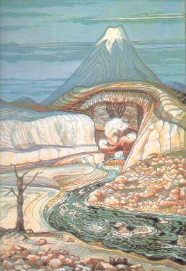
Lonely Mountain |
The
Lonely Mountain by H.E. Riddett
based on a drawing by J.R.R. Tolkien |
 Mountain
realm of the Dwarves captured by Smaug
the Dragon. The Lonely Mountain was a tall, isolated mountain in the far
northeast of Wilderland. It stood near the
edge of Mirkwood, about 50 miles south of the
Grey
Mountains and about 125 miles west of the Iron
Hills.
Mountain
realm of the Dwarves captured by Smaug
the Dragon. The Lonely Mountain was a tall, isolated mountain in the far
northeast of Wilderland. It stood near the
edge of Mirkwood, about 50 miles south of the
Grey
Mountains and about 125 miles west of the Iron
Hills.
The great Front Gate was on the southern side, opening onto a valley between two great spurs of the mountain. At the end of the southwestern spur was Ravenhill, where there was a lookout post. The River Running sprang from beneath the Lonely Mountain and issued from the Front Gate, forming a waterfall as it fell into the valley below. Down in the valley was the town of Dale, where Men dwelled.
Inside the Front Gate a broad paved road ran alongside the river in a wide curve leading into the mountain. Nearby was the Great Chamber of Thror where feasts and councils were held. There were numerous other chambers, halls, passages, and stairways throughout the Lonely Mountain. In the Lower Halls, there was a vast chamber called the Great Hall of Thrain at the root of the mountain. From there a secret passageway led to a hidden door in the western side of the mountain. The Side-door was invisible from the outside except on Durin's Day, when the light of the setting sun would reveal the keyhole.
The Lonely Mountain was the realm of the Kings under the Mountain. The first King was Thrain I, who came to the Lonely Mountain in 1999 of the Third Age after escaping from the Balrog of Khazad-dum. Thrain discovered the fabulous jewel called the Arkenstone at the roots of the mountain. The Dwarves of the Lonely Mountain created new works and began to prosper.
In 2210, Thrain's son Thorin I left the Lonely Mountain and went to the rich and unexplored Grey Mountains where many other Dwarves were gathering. But the Grey Mountains were troubled by Dragons, and in 2590 the Dwarves fled. Some went to the Iron Hills, while others returned to the Lonely Mountain led by Thror - a descendant of Thrain I.
Thror reestablished the Kingdom under the Mountain and he returned the Arkenstone to the Great Hall. The Dwarves made great weapons and armor as well as things of great beauty and wonder, and they became rich and renowned throughout Middle-earth. They expanded the halls of the Lonely Mountain and discovered gold and jewels. They traded ore with the Dwarves of the Iron Hills, and they traded with the Men of Dale for food and other goods.
Smaug the Dragon learned of the Dwarves' great wealth, and in 2770 he captured the Lonely Mountain. Many of the Dwarves were slain, but some survived, including Thror and his son Thrain who escaped through the secret Side-door. Smaug gathered the gold and other treasures into the Great Hall and made it into his lair.
Thror's grandson Thorin Oakenshield returned to the Lonely Mountain in 2941 with twelve other Dwarves and a Hobbit named Bilbo Baggins. With the help of a map passed down by Thror and Bilbo's quick thinking, they were able to find the secret door on Durin's Day. Bilbo crept into Smaug's lair and stole a cup, and the next day he returned and spoke to Smaug. The Dragon emerged from the Lonely Mountain in a rage. He smashed the mountainside with his great tail, destroying the secret door. Smaug then flew to Lake-town, where he was slain by Bard the Bowman.
When the Lake-men and Wood-elves came seeking a share of the treasure, the Dwarves barricaded themselves in the Lonely Mountain. But then an army of Orcs and Wargs came, and the Dwarves joined forces with the Men and Elves to defeat them in the Battle of the Five Armies in the southern valley of the Lonely Mountain. Thorin was killed and he was buried deep beneath the Lonely Mountain. The Arkenstone was laid to rest with him along with the Elvish sword Orcrist, which was said to glow in warning when any enemy approached the Lonely Mountain.
The ten Dwarves who survived the battle settled in the Lonely Mountain. Thorin's kinsman Dain Ironfoot became King under the Mountain, and many Dwarves from the Iron Hills and elsewhere came to live there as well.
The Dwarves of the Lonely Mountain became prosperous again and traded with the Men of Dale and Lake-town once more. They made fine armor and weapons. They were not as skilled in metal work as their ancestors had been, but they excelled at mining and building. They made paved roads and arched halls in the Lonely Mountain as well as towers and terraces on the mountainside.
Around 3017, a messenger from Mordor came to the Lonely Mountain seeking news of Bilbo and the One Ring that he had borne. Dain turned the messenger away and sent a warning to Bilbo at Rivendell.
In March of 3019, the Lonely Mountain and Dale were attacked by Easterlings allied with Sauron. Dain and King Brand of Dale were killed on March 17 during the Battle of Dale. The surviving Dwarves and Men took refuge in the Lonely Mountain, where they were besieged for ten days. On March 27, word reached them of Sauron's downfall and they emerged from the mountain and drove the Easterlings away.
After the War of the Ring, Dain's son Thorin III Stonehelm became King under the Mountain. An ambassador from the Lonely Mountain attended the coronation of Aragorn as King of the Reunited Kingdom of Gondor and Arnor. The Lonely Mountain remained an independent realm under the protection of Aragorn and his descendants.
Names &
Etymology:
Also called Erebor in Sindarin.
The Lonely Mountain was so called because it stood alone and was not part of a mountain range. The name Erebor means "Lonely Mountain." The word ere means "be alone" and ereb means "isolated." The element oro means "up, rise, high." The Dwarf realm in the Lonely Mountain was called the Kingdom under the Mountain.
Sources:
The Hobbit:
"An Unexpected Party," p. 28-35, "On the Doorstep," passim; "Inside Information,"
passim; "Not at Home," passim; "The Gathering of the Clouds," p. 268-73;
"The Clouds Burst," p. 293-98; "The Return Journey," p. 303-4; "The Last
Stage," p. 316-17
The Fellowship
of the Ring: "Many Meetings," p. 240-42; "The Council of Elrond," p.
253-55
Appendix
A of The Lord of the Rings: "Durin's Folk," p. 353-54, 359-60
Appendix
B of The Lord of the Rings: "The Tale of Years," p. 375-76
The History
of Middle-earth, vol. V, The Lost Road and Other Writings: "The Etymologies,"
entries for ERE and ORO
Meneltarma was the highest point in Numenor. It could be see from afar by ships at Sea. From the summit of Meneltarma it was said that the keen-sighted could see westward across the Sea to Avallone on the island of Tol Eressea in the Undying Lands.
The five roots of Meneltarma - called the Tarmasundar - extended in different directions mirroring the five promontories of the star-shaped island. Between the roots on the south side of Meneltarma was Noirinan, the Valley of the Tombs, where the Kings and Queens of Numenor were buried. The River Siril flowed from beneath Menetarma through the Valley of the Tombs and south to the Sea.
Meneltarma was apparently a volcanic mountain. The lower slopes of Menetarma were grassy and gentle but the upper slopes were steeper and could not be climbed. A winding road encircled the mountain from its southwestern root to the north side of the summit. The summit of Meneltarma was a large, flat, empty space.
The Men of Numenor used the summit of Meneltarma to worship Eru, their creator. People could go to the Hallow of Eru at any time. Three times a year, the ruler of Numenor offered prayers there, and many Numenoreans assembled dressed in white clothes and garlands. At the beginning of spring was the Erukyerme, or "Prayer to Eru"; at midsummer was the Erulaitale, or "Praise of Eru"; and at the end of autumn was the Eruhantale, or "Thanksgiving to Eru." In addition to prayers, the Numenoreans also offered the first fruits, probably in the spring.
The Three Prayers spoken by the ruler were the only time speech was allowed upon Meneltarma. No one else was permitted to speak, and at all other times there was silence. Tools and weapons were not allowed there and nothing was ever built on the summit.
Meneltarma was guarded by three eagles called the Witnesses of Manwe - the chief of the Valar. The eagles circled above Meneltarma during the Three Prayers. At other times when anyone came to Meneltarma, the eagles perched on three rocks on the western edge of the summit. No other birds came to the mountain.
Over time, the Men of Numenor became resentful of the fact that they were destined to die and leave the confines of the world to an unknown fate. They did not view mortality as a gift from Eru but saw it as a doom. After the reign of Tar-Ancalimon (2251-2386), the offering of first fruits was neglected and few people visited Meneltarma. Ar-Gimilzor, who reigned from 3102 to 3175, never went to Meneltarma. His son Tar-Palantir tried to repent and resumed the Three Prayers on the Hallow but it was too late.
Ar-Pharazon, the last King of Numenor, was convinced by Sauron to worship Morgoth. Visiting Meneltarma became a crime punishable by death, though Sauron and his followers did not dare defile the Hallow. Ar-Pharazon began to build a fleet to conquer the Undying Lands in a misguided attempt to gain immortality. Smoke issued from the peak of Meneltarma as one of several warning signs to Ar-Pharazon but he did not heed them.
Numenor was destroyed by Eru when Ar-Pharazon's fleet reached the shores of the Undying Lands. Fire erupted from Meneltarma and a great wave covered the land. Ar-Pharazon's wife Tar-Miriel tried to ascend to the summit of Meneltarma but she drowned before she reached it. Numenor sank beneath the Sea. Some believed that the mountain's peak remained above water as the Isle of Meneltarma, but no mariner ever found it.
Names &
Etymology:
The name Meneltarma means
"Pillar of Heaven" in Quenya from menel meaning "heaven" and tarma
meaning "pillar." Also called the Pillar, the Holy Mountain
and the Hallowed Mountain.
The name of Meneltarma in Adunaic, the language of Numenor, was Minul-Târik meaning "Pillar of Heaven" where minul means "heaven" and târik means "pillar."
The roots of Meneltarma were called Tarmasundar meaning "Roots of the Pillar" in Quenya. The word sundar means "roots."
Sources:
Appendix
A of The Lord of the Rings: "The Numenorean Kings," p. 315
The Silmarillion:
"Akallabeth," p. 261-62, 266, 269-70, 272, 277, 279, 281; "Appendix - Elements
in Quenya and Sindarin Names," entries for menel and tar
Unfinished
Tales: "A Description of the Island of Numenor," p. 165-66, 168-69;
"Aldarion and Erendis," p. 175, 183-84, 188, 192, 215 note 16 and 17; "The
Line of Elros: Kings of Numenor," p. 223
The History
of Middle-earth, vol. IX, Sauron Defeated: "The Drowning of Anadune,"
p. 429 (Minul-Târik)
At the roots of Methedras on the eastern side was Fangorn Forest, and there its slopes were verdant. The springs of the Entwash were high up on the mountainside. Treebeard made his home at Wellinghall at the foot of Methedras. He brought the Hobbits Merry Brandybuck and Pippin Took there on February 29, 3019 of the Third Age.
Names &
Etymology:
Also called the Last Mountain.
Methedras
means
"Last Mountain" from meth or methen meaning "end" and ras
meaning "stick up" or "horn" - usually applying to animals but also to
mountains.
Sources:
The Two
Towers: "The Riders of Rohan," p. 32; "Treebeard," p. 73, 85
The History
of Middle-earth, vol. V, The Lost Road and Other Writings: "The Etymologies,"
entries for MET and RAS
Mindolluin |
Minas
Tirith at the foot of Mindolluin
in the New Line film |
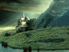 Easternmost
mountain of the White Mountains; site of Minas
Tirith. Mount Mindolluin was a tall mountain with a snow-capped peak
and high glens with deep purple shadows on its slopes.
Easternmost
mountain of the White Mountains; site of Minas
Tirith. Mount Mindolluin was a tall mountain with a snow-capped peak
and high glens with deep purple shadows on its slopes.
On the eastern side of Mindolluin was a spur that formed the Hill of Guard upon which the seven-level walled city of Minas Tirith was built. A narrow shoulder of rock joined the Hill of Guard to the main mass of the mountain. The Tombs of the Kings and Stewards of Gondor were located on that narrow strip under the shadow of Mindolluin.
The Pelennor Fields lay between Mount Mindolluin and the Anduin. The wall called the Rammas Echor extended in a wide curve around the fields from the foot of Mount Mindolluin to the banks of the Anduin and then back to the mountain.
On the southern side of Mount Mindolluin there was an ancient path that led to a hallowed place high on the mountain slopes. This Hallow was only used by the Kings of Gondor, who would go there to offer thanks and praise to a higher power on behalf of their people. As Gondor declined, the Hallow fell out of use and was forgotten.
After the War of the Ring on June 25, 3019 of the Third Age, Aragorn climbed to the Hallow and found a sapling of the White Tree, which had grown from a fruit that had lain dormant on the mountainside for many years. The tree was replanted in Minas Tirith and was seen as a sign of renewal.
Names &
Etymology:
Mindolluin means "towering
blue-head." The element mini means "stand alone, stick out" and
mindo
means "isolated tower." The word luin means "blue."
Sources:
The Two
Towers: "The Palantir," p. 206; "The Forbidden Pool," p. 293
The Return
of the King: "Minas Tirith," p. 23-24, 32, 44; "The Muster of Rohan,"
p. 77; "The Siege of Gondor," p. 81, 87, 100, 103; "The Ride of the Rohirrim,"
p. 108, 110; "The Battle of the Pelennor Fields," p. 124; "The Field of
Cormallen," p. 235; "The Steward and the King," p. 249-50; "Many Partings,"
p. 254
The Silmarillion:
"Of the Rings of Power and the Third Age," p. 291, 304 and index entry
(definition of Mindolluin)
The History
of Middle-earth, vol. V, The Lost Road and Other Writings: "The Etymologies,"
entries for LUG2 and MINI
The Letters
of J.R.R. Tolkien: Letter #156
Misty Mountains |
Map
of the Misty Mountains
|
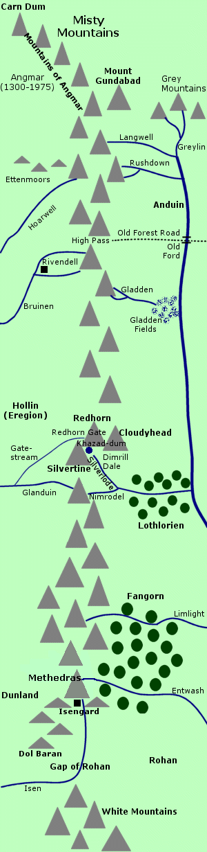 Greatest
mountain range in Middle-earth. Stretching over 800 miles from north to
south, the Misty Mountains divided
Eriador in
the west from Wilderland in the east. The
great Dwarf-realm of Khazad-dum was built beneath
the Misty Mountains, but for much of the Third Age the mountains were infested
with Orcs and other evil creatures.
Greatest
mountain range in Middle-earth. Stretching over 800 miles from north to
south, the Misty Mountains divided
Eriador in
the west from Wilderland in the east. The
great Dwarf-realm of Khazad-dum was built beneath
the Misty Mountains, but for much of the Third Age the mountains were infested
with Orcs and other evil creatures.
At the northernmost peak of the Misty Mountains was Carn Dum, the stronghold of the Witch-king of Angmar from 1300 to 1975 of the Third Age. The mountains south of Carn Dum were known as the Mountains of Angmar.
Gundabad was an important peak in the northern Misty Mountains. The Dwarves believed that Durin, the eldest of the Seven Fathers of the Dwarves, awoke beneath Mount Gundabad in ancient times. Mount Gram was also located in the northern Misty Mountains. The Lord of the Eagles dwelled on an eyrie called the Great Shelf on the eastern side of the northern Misty Mountains.
Just south of the midpoint of the Misty Mountains were the three Mountains of Moria - Cloudyhead, the Redhorn, and the Silvertine. The halls and tunnels of Khazad-dum were delved within these mountains. Inside the Silvertine, the Endless Stair climbed to the peak, where Durin's Tower stood. Between the eastern arms of the Mountains of Moria was the Dimrill Dale where the lake called Mirrormere lay.
The southernmost of the Misty Mountains was Methedras, the Last Peak, beyond which lay a series of foothills ending with Dol Baran. The stronghold of Isengard was built at the southern end of the Misty Mountains, and the forest of Fangorn lay to the east. On the slopes of Methedras was the source of the Entwash, from which the invigorating Ent-draughts were brewed.
In addition to the Entwash, the Limlight also flowed through Fangorn to the Anduin. Several other rivers began in the Misty Mountains as well. In the far north, the Langwell flowed down from the eastern side of the mountains and merged with the Greylin to form the Great River Anduin. Also springing from the eastern Misty Mountains were the Rushdown, the Gladden, and the Nimrodel. The Nimrodel joined with the Silverlode, which had its spring in the Dimrill Dale and flowed through Lothlorien before emptying into the Anduin.
From the western side of the Misty Mountains flowed the Hoarwell, the Bruinen, and the Glanduin. Sirannon, the Gate-stream, began near the West-gate of Moria and may have joined with the Glanduin. The Isen flowed from the southern end of the Misty Mountains and then curved westward through the Gap of Rohan.
The High Pass was one of the main passes over the Misty Mountains. On the western side of the High Pass was Rivendell, and from the eastern side the Old Forest Road led across the Anduin into Mirkwood. In the High Pass was a cave called the Front Porch which had a secret entrance to the Orc stronghold of Goblin-town under the mountains.
The Redhorn Gate - also called the Pass of Caradhras - was another major pass which led over the Mountains of Moria. Eregion was on the western side, and the Dimrill Stair descended from the Redhorn Gate into Dimrill Dale on the eastern side. There were no more passes over the Misty Mountains south of the Redhorn Gate.
The Misty Mountains were created in ancient times by Melkor - also known as Morgoth, the Dark Enemy. He raised the mountains to try to stop the Vala Orome from passing freely through Middle-earth. In the beginning, the Misty Mountains were much taller and more terrible than they were in later Ages.
The Elves who made the Great Journey westward to the Undying Lands found the Misty Mountains in their path. Many crossed the mountains, but others were daunted by their great height and turned aside from the journey. Some of these Elves settled in the woods in Mirkwood and Lothlorien on the eastern side of the Misty Mountains and became known as Wood-elves.
Khazad-dum was founded under the Misty Mountains by Durin, and the great Dwarf realm continued from the First Age through the Second Age and into the Third Age. The mines under the mountains were the only source of the precious metal mithril in all of Middle-earth.
But unknown to the Dwarves, a Balrog had hidden deep under the Redhorn after the War of Wrath at the end of the First Age. In 1980 of the Third Age, the Balrog awoke and slew King Durin VI and his son King Nain I. The Dwarves abandoned Khazad-dum and it became known as Moria, the Black Chasm, and Orcs and other evil creatures came to dwell there.
In 2470, Gollum took the One Ring deep under the Misty Mountains near the High Pass, and he dwelled in a cave with a subterranean lake. The One Ring remained hidden beneath the Misty Mountains for nearly 500 years.
Orcs spread throughout the Misty Mountains during the Third Age. Around 2480, they built secret strongholds and began to block the passes over the mountains. In 2509, Elrond's wife Celebrian was captured by Orcs in the Redhorn Gate and the suffering she endured caused her to leave Middle-earth. Orcs from Mount Gram led by Golfimbul invaded the Shire in 2747 and were defeated by the Hobbits led by Bandobras Took.
Azog was the leader of the Orcs of the Misty Mountains in the late 2700s. He slew King Thrain and the War of the Dwarves and the Orcs began in 2793. The Dwarves sacked many Orc strongholds in the Misty Mountains and at the Battle of Azanulbizar in 2799 they defeated the Orcs and slew Azog. But the Dwarves did not reclaim Khazad-dum at that time because the threat of the Balrog still lurked within.
The Orcs gradually regained their strength in the Misty Mountains. A group of Orcs led by the Great Goblin waylaid travellers in the northern Misty Mountains. In the High Pass in the summer of 2941, they captured Thorin Oakenshield along with twelve Dwarves and one Hobbit named Bilbo Baggins. Gandalf slew the Great Goblin and Thorin & Company escaped. Under the mountains, Bilbo became lost and found the One Ring. Azog's son Bolg mustered a force at Mount Gundabad to pursue and fight the Dwarves, but the Orcs were defeated in the Battle of the Five Armies.
In 2989, Balin led an expedition of Dwarves to recolonize Khazad-dum. The waters at the West-gate began to rise because the Gate-stream had been dammed. In the resulting pool dwelled a tentacled creature called the Watcher in the Water, which may have come from deep under the Misty Mountains. The colony lasted only five years before the Dwarves were overcome by Orcs and other evil creatures.
The Fellowship of the Ring tried to cross the Misty Mountains using the Redhorn Gate in January of 3019 but were turned back by a blizzard that may have been the work of the Enemy or of the Redhorn itself. Instead, the Fellowship passed under the mountains through Moria on January 13 to 15. Gandalf confronted the Balrog and fell with the creature into an abyss. They climbed the Endless Stair to the top of the Silvertine, where they fought the Battle of the Peak from January 23 to 25. Gandalf cast down the Balrog and died himself. He was returned to life as Gandalf the White and he was rescued from the Silvertine by Gwaihir the Windlord.
After Sauron was defeated, Aragorn, King Elessar, began to drive out the Orcs and other evil creatures that remained in the land. It is likely that this included the Misty Mountains. According to the legends of the Dwarves, there came a time when a king named Durin VII recolonized Khazad-dum and it became a great mountain realm once more.
Names &
Etymology:
Also called the Mountains of
Mist or the Towers of Mist. The Sindarin name was Hithaeglir.
The name Hithaeglir means "Line of Misty Peaks" from hîth meaning "mist" and oeglir meaning "range of mountain peaks."
Sources:
The Hobbit:
"An Unexpected Party," 26; "Over Hill and Under Hill," passim; "Riddles
in the Dark," passim; "Out of the Frying-Pan into the Fire," p. 105-6,
114, 118-21; "The Clouds Burst," p. 292-93
The Fellowship
of the Ring: "The Shadow of the Past," p. 63; "Fog on the Barrow-downs,"
p. 157; "The Ring Goes South," p. 294-307; "A Journey in the Dark," passim;
"The Bridge of Khazad-dum," passim; "Lothlorien," p. 347-48
The Two
Towers: "The Riders of Rohan," p. 32; "Treebeard," p. 73, 85; "The
White Rider," p. 105-106
Appendix
A of The Lord of the Rings: "The North-kingdom and the Dunedain," p.
320, 323; "Durin's Folk," p. 352-56
Appendix
B of The Lord of the Rings: "The Tale of Years," p. 366, 368
The Silmarillion:
"Of
the Coming of the Elves," p. 54; "Of the Sindar," p. 91, 94; "Appendix
- Elements in Quenya and Sindarin Names," entry for hith; Index
entry for Hithaeglir
The History
of Middle-earth, vol. V, The Lost Road and Other Writings: "The Etymologies,"
entries for AYAK and LIR2
The History
of Middle-earth, vol. XII, The Peoples of Middle-earth: "Of Dwarves
and Men," p. 301, 305, 322-23 note 25
The slopes of Mount Dolmed were wooded and Ents could be found there. Around 503 of the First Age, Dwarves from Nogrod attacked Doriath and stole the Nauglamir. On their way home, the Dwarves were defeated by Beren and the Green-elves of Ossiriand at Sarn Athrad where the Dwarf-road crossed the Gelion. The surviving Dwarves fled up the slopes of Mount Dolmed and were confronted by the Ents. None of the Dwarves ever returned to Nogrod.
The range of the Blue Mountains was broken during the War of Wrath at the end of the First Age. Belegost and Nogrod were destroyed and it seems likely that Mount Dolmed no longer existed as it does not appear on maps of the Blue Mountains in the Third Age.
Names &
Etymology:
The name Dolmed means "Wet
Head" in Sindarin from dol meaning "head" - often used for hills
and mountains - and méd meaning "wet."
Sources:
The Silmarillion:
"Of the Sindar," p. 91-92, 96; "Of the Fifth Battle," p. 193; "Of the Ruin
of Doriath," p. 235; Index entry for Dolmed; "Appendix - Elements
in Quenya and Sindarin Names," entry for dol
The History
of Middle-earth, vol. V, The Lost Road and Other Writings: "The Etymologies,"
entry for MIZD
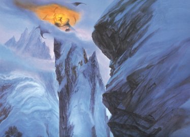
Mount Doom |
Mount
Doom by Jeremy Bennett
|
 Volcanic
mountain in Mordor where the One
Ring was created and destroyed. Mount Doom stood alone on the plateau
of Gorgoroth in northwestern Mordor
about 90 miles from the Black
Gate. The mountain was 30 miles directly west of
Sauron's
stronghold, the Dark Tower.
Volcanic
mountain in Mordor where the One
Ring was created and destroyed. Mount Doom stood alone on the plateau
of Gorgoroth in northwestern Mordor
about 90 miles from the Black
Gate. The mountain was 30 miles directly west of
Sauron's
stronghold, the Dark Tower.
Mount Doom was about 4,500 feet high. The base rose about 3,000 feet; its long grey slopes were rugged and broken and covered with ash and slag and burned stone. The central cone had sheer sides and was about half again as high - or 1,500 feet tall. There was a jagged crater at the top from which smoke, fumes and lava issued. Beneath the mountain was a subterranean core of intense heat and undying fire.
A road led to Mount Doom from the Morgul Pass southwest of the mountain. Another road called Sauron's Road led from the Dark Tower to the east side of Mount Doom. It was a broad road paved with rubble and ash and it was repaired and maintained by Orcs.
Sauron's Road climbed the eastern slopes on a causeway and circled up the mountainside from south to north and back to the eastern side. There high on the central cone was a doorway facing the Dark Tower. Inside was Sammath Naur, the Chambers of Fire, where a great fissure called the Crack of Doom led down to the Fire of Doom at the mountain's core.
Sauron chose Mordor as his realm in the year 1000 of the Second Age in large part because of its volcanic mountain. He used the fires of the mountain in his sorceries, and in 1600 he forged the One Ring there in the Chambers of Fire. Sauron infused the Ring with much of his own power, and it could only be destroyed by casting it back into the fires in which it had been made.
Sauron escaped the Downfall of Numenor and returned to Mordor in 3320. He was angered to learn that Elendil had also escaped and was establishing the Kingdom of Gondor on his borders. As Sauron prepared for war, the Mountain of Fire burst into flame and the Men of Gondor named it Amon Amarth, or Mount Doom.
At the end of the War of the Last Alliance in 3441, Sauron came down from the Dark Tower. On the slopes of Mount Doom he fought with Elendil and Gil-galad and all three of them fell. Elendil's son Isildur took up the shards of his father's sword Narsil and cut the One Ring from Sauron's hand. Elrond and Cirdan counselled Isildur to cast the Ring into the Crack of Doom and destroy it, but he refused.
Because the Ring survived, Sauron's spirit endured. Sauron returned to Mordor in 2942 of the Third Age, and in 2954 Mount Doom burst into flame once more. The inhabitants of Ithilienon the border of Mordor fled. Smoke was seen rising from Mount Doom in the years following.
At the Council of Elrond on October 25, 3018, it was decided that the Ring had to be taken to Mount Doom and destroyed. Frodo Baggins, a Hobbit of the Shire, volunteered to undertake this quest.
On the Dawnless Day of March 10, 3019, a Darkness emanating from the depths of Mount Doom spread out westward from Mordor across the lands of Gondor and Rohan. The Darkness was sent by Sauron to cause fear and uncertainty among his adversaries. The Darkness finally broke in the West at dawn on March 15, and that day Sauron's forces were defeated at the Battle of the Pelennor Fields. The Darkness was driven back to the borders of Mordor, but great columns of black smoke continued to rise from Mount Doom and the roof of clouds remained over the Black Land.
Frodo and Sam Gamgee reached Mount Doom on March 24. They had approached the mountain from the northwest. The air became more difficult to breathe because of the fumes from the volcano and they had found no water for days on the ashy plain at the mountain's feet. The burden of the Ring grew heavier on Frodo as he drew near the place where it had been created.
On the morning of March 25, Frodo was so weighed down by the Ring that he was unable to walk. He started to crawl up the mountainside, but Sam picked his master up and carried him on his back. More than halfway up the base, Sam found Sauron's Road and followed it upward. At a bend in the road, the Hobbits were ambushed by Gollum. Frodo fought him off and continued up the mountain. Sam threatened to kill Gollum but he decided to spare the creature's life and followed his master to the Chambers of Fire.
At the edge of the Crack of Doom, in the chamber where the Ring had been forged, Frodo was unable to resist the will of the Ring any longer and he claimed it for himself. Sauron became aware of Frodo and all his thought was bent on Mount Doom. The Nazgul were sent racing toward the mountain to seize Frodo. But then Gollum attacked Frodo and bit the Ring from his hand. In his joy, Gollum lost his balance and fell into the Crack of Doom.
The Ring was consumed in the Fire of Doom at the core of the mountain. The mountain shook and its fires roared. Smoke and lava poured out of the Chambers of Fire and the side of the mountain was split asunder. Sauron was utterly defeated by the destruction of the Ring, and the Nazgul were engulfed by the fire bursting forth from Mount Doom.
Frodo and Sam managed to escape to a small hill at the foot of Mount Doom. Rivers of molten fire flowed down the mountainside toward them and ash rained from the sky. The Hobbits were stranded amid the ruin wrought by the eruption of Mount Doom until Gandalf came with the Great Eagles Gwaihir, Landroval, and Meneldor and bore them away to safety.
Names &
Etymology:
Called Orodruin and Amon
Amarth in Sindarin. Also called the Fiery Mountain, the Fire-mountain
and the Mountain of Fire.
Orodruin means "Mountain of Blazing Fire" from orod meaning "mountain" and ruin meaning "red flame." Amon Amarth means "Mount Doom" from amon meaning "hill" and amarth meaning "doom."
Sources:
The Fellowship
of the Ring: "The Shadow of the Past," p. 70-71; "The Council of Elrond,"
p. 255-56, 258, 280, 282-84; "The Ring Goes South," p. 289, 294, 299; "The
Breaking of the Fellowship," p. 417, 419-20
The Two
Towers: "The Passage of the Marshes," p. 231; "The Black Gate Is Closed,"
p. 252; "Of Herbs and Stewed Rabbit," p. 260; "The Window on the West,"
p. 290; "The Choices of Master Samwise," p. 341
The Return
of the King: "The Siege of Gondor," p. 81; "The Tower of Cirith Ungol,"
p. 174-77, 181; "The Land of Shadow," p. 194, 196-97, 200, 204; "Mount
Doom," passim; "The Field of Cormallen," p. 228-29
Appendix
A of The Lord of the Rings: "The Numenorean Kings," p. 317-18
Appendix
B of The Lord of the Rings: "The Tale of Years," p. 364-65, 371, 375
The Silmarillion:
"Of the Rings of Power and the Third Age," p. 288, 292-95; "Appendix -
Elements in Quenya and Sindarin Names," entries for amarth, amon, orod,
and ruin
Source:
The Hobbit:
"An Unexpected Party," 26
When the forest was known as Greenwood the Great, the mountains were called Emyn Duir - the Dark Mountains - because of the dense woods of fir trees on their slopes. At the end of the Second Age, Oropher, who was then the king of the Wood-elves, lived in the glens of the Emyn Duir.
Around 1050 of the Third Age, Sauron built a stronghold on Dol Guldur and a shadow fell over the forest. Evil creatures came to live there, and many of most terrible dwelled in the mountains. The forest came to be called Taur-nu-Fuin, "forest under night," or Mirkwood in the Common Speech. The mountains were named Emyn-nu-Fuin, "mountains under night," or the Mountains of Mirkwood.
After the War of the Ring, the mountains became the southern border of the realm of King Thranduil. The shadow was lifted from Mirkwood and it was named Eryn Lasgalen, the Wood of Greenleaves. It is not known whether the Mountains of Mirkwood were then called by their original name - Emyn Duir - or given a new name.
Names &
Etymology:
Called Emyn-nu-Fuin in Sindarin.
Earlier called Emyn Duir or the Dark Mountains.
Emyn-nu-Fuin means "mountains under night." The word emyn means "hills"; nu means "down below, underneath"; and fuin means "gloom, darkness." Emyn Duir means "Dark Mountains." The word duir is a form of dûr (meaning "dark") used to modify a plural word.
Sources:
Appendix
B of The Lord of the Rings: "The Tale of Years," p. 375
Unfinished
Tales:
"The Disaster of the Gladden Fields," note 14, p. 280-81
The Atlas
of Middle-earth by Karen Wynn Fonstad: "Map of Wilderland," p. 76
The History
of Middle-earth, vol. V, The Lost Road and Other Writings: "The Etymologies,"
entry for DO3, DÔ
Sindarin
- The Noble Tongue (derivation of duir from dûr)
The region of Ithilien belonging to Gondor was west of the western range of the Mountains of Shadow. South of the southern range was Harad, while Khand bordered on the southeastern end.
The Morgulduin and the Poros flowed west from the western range of the Mountains of Shadow into the Anduin. The Harnen flowed from the southern range southwestward to the Bay of Belfalas. Inside Mordor, a river from the western range and another river from the southern range flowed into the Sea of Nurnen.
At its northern end, the western range of the Mountains of Shadow met the Ash Mountains, which formed Mordor's northern border. Between the two ranges was Cirith Gorgor, the Haunted Pass, barred by the Black Gate. The Towers of the Teeth stood on hills on either side of the Black Gate. Behind the Black Gate was the valley of Udun, and at the other end of the valley was the pass called the Isenmouthe. The castle of Durthang was in the Mountains of Shadow overlooking Udun.
The Morgai was an inner ridge that ran southward from Udun alongside the Mountains of Shadow. The eastern side of the Mountains of Shadow was sheer, and a deep ravine separated the range from the Morgai. A path ran through the ravine along a dry streambed. The Morgai was lower than the main range, and its peaks were jagged. Thorn bushes grew on the Morgai as did a few trees and some coarse grass.
Beyond the Morgai was the great plain of Gorgoroth where Mount Doom stood about 40 miles to the east. Gorgoroth was partially enclosed by a spur that jutted eastward from the Mountains of Shadow.
The Morgul Vale was on the western side of the Mountains of Shadow, opening onto Ithilien. It was located about 90 miles south of the Black Gate. The stronghold of Minas Morgul (formerly Minas Ithil) was on the southern side of the Morgul Vale. The Morgulduin flowed from the Morgul Vale and the Morgul-road ran alongside it.
At the eastern end of the Morgul Vale where the mountains were lower, the Morgul-road crossed the Morgul Pass into Mordor. The Morgul-road continued across a bridge over the ravine between the Mountains of Shadow and the Morgai and then descended onto Gorgoroth. There were also stairs going down into the ravine from the western end of the bridge.
On the northern side of the Morgul Vale, the Straight Stair and the Winding Stair climbed high up into the Mountains of Shadow. At the top was a tunnel that was the lair of the Great Spider Shelob, and beyond was the high pass called Cirith Ungol guarded by the Tower of Cirith Ungol. A road ran down from the Tower to join the Morgul-road.
Shelob came to live in the Mountains of Shadow sometime during the early part of the Second Age. She devoured those who came near her lair. Shelob had numerous offspring that spread throughout the Mountains of Shadow.
Sauron came to Mordor around 1000 of the Second Age. The mountain ranges that enclosed Mordor on three sides were a factor in choosing Mordor as his realm.
After Gondor was founded in 3320 of the Second Age, the Men of Gondor built Minas Ithil, the Tower of the Moon, at the foot of the Mountains of Shadow to keep watch on Mordor. Minas Ithil was the home of Isildur. Sauron captured Minas Ithil in 3429. He was defeated in the War of the Last Alliance in 3441 and his spirit left Mordor and hid in the East.
Minas Ithil returned to the control of Gondor at that time. The Men of Gondor then built the Tower of Cirith Ungol high in the Mountains of Shadow and the Towers of the Teeth on either side of the Black Gate at the point where the Mountains of Shadow met the Ash Mountains. But as Gondor's power declined, their vigilance over Mordor decreased.
In 1980 of the Third Age, the Lord of the Nazgul returned to Mordor. He took control of the Tower of Cirith Ungol, and in 2000 he besieged Minas Ithil. The Nazgul captured Minas Ithil in 2002 and it was renamed Minas Morgul, the Tower of Black Sorcery.
Sauron returned to Mordor in 2942. It was believed that Sauron could control storms in the Mountains of Shadow. The Men of Gondor did not dare to venture into the Mountains of Shadow as Sauron's strength grew.
Around 2980, Gollum came to the Mountains of Shadow and found the Stairs of Cirith Ungol. He encountered Shelob and promised to bring her food. He dwelled for many years in the mountains. Gollum was eventually captured by Sauron but was allowed to escape in hopes that he would lead Sauron to the One Ring. Aragorn searched for Gollum in the Mountains of Shadow but did not find him until after his release in the Dead Marshes.
Gollum brought Frodo Baggins and Sam Gamgee to the Stairs of Cirith Ungol on March 10, 3019. He led them into Shelob's Lair on March 12 in hopes that Shelob would kill Frodo and leave him the Ring. Shelob stung Frodo but Sam stabbed her with Sting. It is not known if she died or if she crawled deep into the mountains to recover. Frodo was taken by Orcs to the Tower of Cirith Ungol, but Sam had the Ring in his keeping and he rescued Frodo from the Tower on March 15.
The Hobbits descended into the ravine between the Mountains of Shadow and the Morgai. On March 16, they climbed the Morgai and looked across Gorgoroth to Mount Doom. There was no way down to the plain from the Morgai so they returned to the ravine until they came to its northern end near Udun on March 18.
Even after Sauron was defeated, the Morgul Vale remained tainted by the evil of the Lord of the Nazgul for many years. But when Aragorn surveyed his realm from Mount Mindolluin, the shadow appeared to have lifted from the Mountains of Shadow and instead they were veiled in a golden mist.
Names &
Etymology:
The Mountains of Shadow were
so called because of the gloom that hung over them. Also called the Shadowy
Mountains.
The Sindarin name was Ephel Dúath. The word ephel means "outer fence" and the word dúath means "dark shadow" from dú meaning "night, dimness" and gwath meaning "shadow."
The name Morgai means "black fence" from mor meaning "dark, black" and gai from cai meaning "fence."
Sources:
The Fellowship
of the Ring: "The Council of Elrond," p. 257, 265; "The Ring Goes South,"
p. 302
The Two
Towers: "The Black Gate Is Closed," p. 244-52; "Of Herbs and Stewed
Rabbit," p. 256-59; "The Forbidden Pool." p. 301-2; "Journey to the Cross-roads,"
p. 306, 308; "The Stairs of Cirith Ungol," passim; "Shelob's Lair," passim;
"The Choices of Master Samwise," passim
The Return
of the King: "The Muster of Rohan," p. 74; "The Black Gate Opens,"
p. 160-61; "The Tower of Cirith Ungol," passim; "The Land of Shadow," passim;
"The Steward and the King," p. 249
Appendix
A of The Lord of the Rings: "The Stewards," p. 336
Appendix
E of The Lord of the Rings: "Writing and Spelling," p. 392 (definition
of
ephel)
Unfinished
Tales: "The Disaster of the Gladden Fields," p. 282 note 16 (definition
of cai)
The Silmarillion:
"Of the Rings of Power and the Third Age," p. 291-92, 297; "Appendix -
Elements in Quenya and Sindarin Names," entries for du, gwath, and
mor
The History
of Middle-earth, vol. VII, The Treason of Isengard: "The Council of
Elrond," p. 145; "The First Map," p. 309
Redhorn (Caradhras) |
The
Fellowship climbing the Redhorn
in the New Line film |
 Mountain
in the Misty Mountains. The Redhorn was one of the
three Mountains of Moria under which lay the ancient Dwarf realm of Khazad-dum.
The other two mountains were Cloudyhead and the
Silvertine.
The Redhorn was also commonly known as Caradhras, as it was called
by the Elves.
Mountain
in the Misty Mountains. The Redhorn was one of the
three Mountains of Moria under which lay the ancient Dwarf realm of Khazad-dum.
The other two mountains were Cloudyhead and the
Silvertine.
The Redhorn was also commonly known as Caradhras, as it was called
by the Elves.
The Redhorn was the tallest and northernmost of the three Mountains of Moria. Its peak was snow-capped and in the light of the rising or setting sun it could appear stained red as if with blood. The Redhorn had a cruel reputation, and the Redhorn Gate leading over the Misty Mountains was narrow and dangerous. The pass overlooked a deep ravine as it wound up the southern side of the Redhorn. It led down the Dimrill Stair into the Dimrill Dale on the eastern side of the mountains.
The mithril lodes under the Mountains of Moria led north to the roots of the Redhorn. There in the darkness the Dwarves delved too deep and awoke the Balrog that had lain hidden there since the fall of Morgoth at the end of the First Age. King Durin VI was slain by the Balrog in 1980 of the Third Age. The Dwarves abandoned Khazad-dum and it became an evil place.
On January 11-12, 3019, the Fellowship tried to cross the Misty Mountains at the Redhorn Gate but they were thwarted by a blizzard. They thought they heard shrill cries and howls of laughter and rocks fell down at them from the mountainside. The snow became too deep for them to continue and they were forced to turn back. Legolas discovered that the storm had only affected the Redhorn Gate and that it was clear to the west. Boromir suggested that the storm might have been a contrivance of the Enemy, but Gimli believed it was the ill will of the Redhorn itself.
As soon as the Fellowship had retreated from the Redhorn Gate there was an avalanche and the pass was completely blocked. They then decided to go under the mountains through the Mines of Moria.
Names &
Etymology:
The Redhorn was called Caradhras
by the Elves. Because of its ill reputation it was referred to as Caradhras
the Cruel. The Dwarves called it Barazinbar or simply Baraz.
The Redhorn was so named because the mountain's peak appeared red in the light of the rising or setting sun. The Sindarin name Caradhras also means "red horn." The word caran means "red." The element ras means "stick up" or "horn" - usually applying to animals but also to mountains. Similarly the Dwarvish name Barazinbar translates as "red horn" from baraz meaning "red, ruddy" and inbar meaning "horn."
Sources:
The Fellowship
of the Ring: "The Ring Goes South," p. 295-307; "A Journey in the Dark,"
p. 308, 311, 331; "Lothlorien," p. 347; "The Mirror of Galadriel," p. 371
The Return
of the King: "Many Partings," p. 263
Appendix
A of The Lord of the Rings: "Durin's Folk," p. 353
The History
of Middle-earth, vol. V, The Lost Road and Other Writings: "The Etymologies,"
entries for KARAN and RAS
The History
of Middle-earth, vol. VII, The Treason of Isengard: "The Ring Goes
South," p. 174 footnote 18 (translation of Barazinbar)
Red Mountains |
Map
of the Red Mountains in ancient times
(based on Map IV, HoME IV, p. 249) |
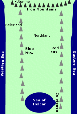 The
Mountains of the East. The Red Mountains were also called the Orocarni.
They were located in Rhun in far eastern Middle-earth.
The
Mountains of the East. The Red Mountains were also called the Orocarni.
They were located in Rhun in far eastern Middle-earth.
The Red Mountains were created around the 3,450th Year of the Valar when Morgoth destroyed the two Lamps of the Valar that provided light to Middle-earth. There was a great upheaval of the lands and seas, and the Red Mountains in the east and the Blue Mountains in the west were formed.
At the southern end of the range, the Red Mountains bordered on the eastern shore of the Inland Sea of Helcar. Many streams flowed down from the Red Mountains into the Sea of Helcar. Cuivienen was a bay on the eastern shore of the Sea of Helcar in the shadow of the Red Mountains.
In 1050 of the Years of the Trees, the Elves awoke at Cuivienen. They were discovered by the Vala Orome around 1085. Most of the Elves left Cuivienen to begin the Great Journey westward around 1105, but some remained behind in the foothills of the Red Mountains.
Sometime after the awakening of Elves, the Dwarves awoke under mountain ranges throughout Middle-earth. Four kindreds of the Dwarves - the Ironfists, Stiffbeards, Blacklocks, and Stonefoots - arose in the East. Although the Red Mountains are not named as a place of awakening, it seems possible since they were a major eastern mountain range.
Over time, the geography of Middle-earth was further changed, particularly during the cataclysmic events of the War of Wrath at the end of the First Age and the destruction of Numenor near the end of the Second Age. It is unclear whether the Red Mountains were affected by these changes.
It was said that Cuivienen could no longer be reached, and one source (HoME XI, p.174) speculates that the Sea of Helcar may have dwindled to become the Sea of Rhun. Maps of Middle-earth in the Third Age do not show anything east of the Sea of Rhun, but it is possible that the Red Mountains still stood in the wide lands beyond.
Names &
Etymology:
The Red Mountains were known
as the Mountains of the East. The Quenya name was Orocarni
meaning "red mountains" from carnë meaning "red" and orofrom
orod
meaning "mountain."
Sources:
The Silmarillion:
"Of the Beginning of Days," p. 36-37; "Of the Coming of the Elves," p.
48-49; "Appendix - Elements in Quenya and Sindarin Names," entries for
caranand
orod
The History
of Middle-earth, vol. IV, The Shaping of Middle-earth:
"The Ambarkanta," p. 239, 249 Map IV, 251 Map V, 255-56
The History
of Middle-earth, vol. X, Morgoth's Ring: "The Annals of Aman," p. 53,
72, 77 §41, 81-82
The History
of Middle-earth, vol. XI, The War of the Jewels: "The Later Quenta
Silmarillion," p. 174
The History
of Middle-earth, vol. XII, The Peoples of Middle-earth: "Of Dwarves
and Men," p. 301
Silvertine (Zirak-zigil) |
Gandalf
and the Balrog on the Silvertine
by John Howe |
 Mountain
in the Misty Mountains. Silvertine was one of the
three Mountains of Moria under which lay the ancient Dwarf realm of Khazad-dum.
The other two mountains were Cloudyhead and the
Redhorn.
Mountain
in the Misty Mountains. Silvertine was one of the
three Mountains of Moria under which lay the ancient Dwarf realm of Khazad-dum.
The other two mountains were Cloudyhead and the
Redhorn.
The Dwarves called the mountain Zirak-zigil. In ancient times, they built the Endless Stair - a spiral staircase of many thousand steps - from the roots of the mountain up to its peak. On an eyrie atop the mountain they builtDurin's Tower. By the end of the Third Age the stair and the tower were remembered only in legend.
Then on January 23, 3019, Gandalf and the Balrog climbed the Endless Stair to the summit of the Silvertine. There they fought the Battle of the Peak, which lasted three days. During the battle, Durin's Tower was destroyed and the stairs were blocked. The Balrog was killed and Gandalf the Grey died and was returned to life as Gandalf the White. He was rescued from the Silvertine by Gwaihir the Windlord on February 17.
Names &
Etymology:
Silvertine was called Celebdil
the White by the Elves and Zirakzigil (also written as Zirak-zigil)
or simply Zirak by the Dwarves.
A tine is a point or prong. Celebdil means "silver point" from celeb meaning "silver" and til or dil meaning "point, horn." The translation of Zirakzigil is most likely "silver spike," but it is not clear which element means "silver" and which means "spike." A note written by J.R.R. Tolkien proposed that zirak meant "silver" and zigil meant "spike," but a later note said the reverse - that zigil meant "silver" and zirak meant "spike."
Sources:
The Fellowship
of the Ring: "The Ring Goes South," p. 296; "Lothlorien," p. 347
The Two
Towers: "The White Rider," p. 105-106
The Return
of the King: "The Field of Cormallen," p. 228; "Many Partings," p.
263
The Silmarillion:
"Appendix
- Elements in Quenya and Sindarin Names," CELEB entry
The History
of Middle-earth, vol. V, The Lost Road and Other Writings: "The Etymologies,"
TIL
entry
The History
of Middle-earth, vol. VII, The Treason of Isengard: "The Ring Goes
South," p. 174-75 note 22 (translation of Zirakzigil)
Names &
Etymology:
The name Sorontil means "eagle
horn" from the Quenya word soron meaning "eagle" and til meaning
"point, horn."
Sources:
Unfinished
Tales: "A Description of the Island of Numenor," p. 167; Index, entry
for Sorontil
The History
of Middle-earth, vol. V, The Lost Road and Other Writings: "The Etymologies,"
entries for THOR, THORON and TIL
Starkhorn |
The
Starkhorn in the New Line film
|
 Mountain
in the White Mountains. The Starkhorn was located
near the northwestern end of the mountain range in the valley of Harrowdale.
The Starkhorn was one of three great mountains forming the eastern wall
of the valley. Irensaga was the northernmost, near
the mouth of the valley; the Dwimorberg - where
the entrance to the Paths of the
Dead was located - was in the middle; and the Starkhorn was the southernmost,
near the head of the valley.
Mountain
in the White Mountains. The Starkhorn was located
near the northwestern end of the mountain range in the valley of Harrowdale.
The Starkhorn was one of three great mountains forming the eastern wall
of the valley. Irensaga was the northernmost, near
the mouth of the valley; the Dwimorberg - where
the entrance to the Paths of the
Dead was located - was in the middle; and the Starkhorn was the southernmost,
near the head of the valley.
The stronghold of Dunharrow was on a great shelf between the three mountains. Dunharrow could be reached by a zigzag path carved into an outflung root of the Starkhorn.
The Starkhorn was a tall, massive mountain. Its jagged peak was always covered in snow and was often wreathed in clouds.
Names &
Etymology:
The name Starkhorn meant
"peak standing up stiff like a spike." A less common meaning of stark
is "stiff," while horn
refers to a mountain peak.
Sources:
The Return
of the King: "The Muster of Rohan," p. 64, 67-68
"Nomenclature
of The Lord of the Rings," entry for Starkhorn
Between the arms of the Thrihyrne was the valley called the Deeping-coomb, which narrowed into the ravine of Helm's Deep. The fortress of the Hornburg stood on a spur of rock on the northern side of the ravine. Beneath the Thrihyrne were the magnificent Glittering Caves.
Names &
Etymology:
Thrihyrne means "three horns"
from the Old English ðrie meaning "three" and
hyrne meaning
"horn, corner, angle." The word ðri-hyrne
means "three-cornered,
triangular."
Sources:
The Two
Towers: "Helm's Deep," p. 132-33; "The Palantir," p. 202
The Lord
of the Rings: A Reader's Companion by Wayne G. Hammond and Christina
Scull: "Helm's Deep," p. 412
Old English
White Mountains |
The
White Mountains in the New Line
film
|
 Mountain
range of Gondor and Rohan.
The White Mountains were high and their peaks were covered with snow year-round.
(See
a map of the White Mountains below.)
Mountain
range of Gondor and Rohan.
The White Mountains were high and their peaks were covered with snow year-round.
(See
a map of the White Mountains below.)
Rohan was north of the White Mountains. Much of Gondor was south of the White Mountains, though the region of Anorien was north of the mountains at their eastern end.
Mount Mindolluin was the last peak at the eastern end of the White Mountains. Minas Tirith was at the foot of Mount Mindolluin. The city was built on the Hill of Guard, which was joined to Mount Mindolluin by a spur of rock.
At its western end, the mountain range split into two forks. One fork curved north to the Gap of Rohan, which divided the White Mountains from the Misty Mountains. The distance between the Gap of Rohan and Mount Mindolluin was about 425 miles.
The other fork continued westward. The distance from the western end of this fork to Mount Mindolluin was about 550 miles. At the far western end of the fork, there was an outlier of mountains that stretched southward for about 200 miles onto to the peninsula of Andrast.
On the northern side of the White Mountains at their eastern end was the Druadan Forest. The Stonewain Valley passed between the forest and the mountains.
The Beacon-hills of Gondor ran along the northern side of the White Mountains from the Druadan Forest to the Firien Wood. Amon Din and Eilenach stood separate from the mountain range, while Nardol, Erelas, Min-Rimmon, Calenhad, and Halifirien were foothills of the White Mountains. Halifirien rose out of a deep valley in the White Mountains called the Firien-dale. The Mering Stream began in the Firien-dale and flowed through the Firien Wood and on to join the Entwash.
West of the Mering Stream was Rohan. The White Mountains formed Rohan's southern border. The valley of Harrowdale was located in the White Mountains in Rohan. The town of Edoras stood at the entrance to the valley. The River Snowbourn sprang from the White Mountains in Harrowdale and flowed into the Entwash.
On the eastern side of Harrowdale were three great peaks: Irensaga on the northern end, the Dwimorberg in the middle, and the Starkhorn to the south. The refuge of Dunharrow was high up on the slopes of these three mountains. The Dark Door to the Paths of the Dead was in Dwimorberg. The Paths of the Dead ran under the White Mountains to the Blackroot Vale on the southern side of the range.
West of Harrowdale, in the northward fork of the White Mountains, was Helm's Deep. Helm's Deep was in the Deeping-coomb, a valley between the arms of the three-peaked mountain called the Thrihyrne. Beneath the Thrihyrne were the Glittering Caves. The Deeping-stream flowed from the Glittering Caves through the Deeping-coomb and out into the Westfold Vale.
The River Adorn began between the two forks of the western White Mountains. The river flowed westward to join the Isen.
Eight rivers sprang from the southern side of the White Mountains. The Lefnui began in the western fork of the White Mountains and flowed south to the Bay of Belfalas. The Blackroot emerged from the southern entrance of the Paths of the Dead and flowed through the Blackroot Vale past the Hill of Erech at the foot of the White Mountains and on to the Bay.
Just east of the Blackroot Vale, a short southward spur branched off from the main range. The three mountains of the spur were called Dol Tarlang, Cul Veleg, and Cul Bin. A passage called Tarlang's Neck ran between the White Mountains and the spur.
The River Ciril sprang from the mountains near Tarlang's Neck. The Ciril joined the Ringlo, which began in a lake formed by melting snow high in the White Mountains and descended into the Ringlo Vale. Both rivers flowed through Lamedon, which was a province of Gondor at the foot of the White Mountains. The town of Calembel was at the fords of the Ciril, and the town of Ethring was on the Ringlo. The Ciril and Ringlo joined the Blackroot.
Farther east, the Gilrain, the Celos, the Sirith, and the Erui all began in the White Mountains. The Gilrain joined the Serni and flowed into the Bay of Belfalas. The Celos and Sirith merged and flowed into the Anduin. The Erui flowed into the Anduin through Lossarnach, a province of Gondor at the southeastern end of the White Mountains.
In the First Age, the race of Men called the Druedain came from the lands south of Mordor and crossed the Anduin. They settled in the valleys on both sides of the White Mountains and in the forests on the northern side of the mountains. Later, other Men came from the East and drove the Druedain from the White Mountains, though the Druedain remained in the Druadan Forest and in the mountain spur on Andrast.
The new arrivals became known as the Men of the Mountains. During the Dark Years of the Second Age, the Men of the Mountains worshipped Sauron. But some Men migrated away from the White Mountains during the Dark Years; these were the ancestors of the Men of Dunland and the Men of Bree.
At the end of the Second Age, the survivors of Numenor founded the Kingdom of Gondor with territory on both sides of the White Mountains. Gondor was ruled jointly by Isildur and Anarion. Isildur met with the King of the Men of the Mountains, who swore allegiance to Gondor. But when Isildur called upon the Men of the Mountains to join the war against Sauron, they refused. Isildur cursed them and said that they would never rest until they fulfilled their oath.
The Men of the Mountains hid in the tunnels behind the Dark Door in Dwimorberg where they had built an underground temple. When they eventually died, their spirits continued to haunt the tunnels which became known as the Paths of the Dead. They remained there for over 3,000 years and they did not allow the living to enter their domain.
Men of Gondor lived in the valleys of the White Mountains. Some hardy folk also lived higher up in mountain villages. Lossarnach and Lamedon were two populous provinces at the foot of the mountains. Men also lived in the river valleys of the Ringlo and the Blackroot. The Men of the Blackroot Vale were sometimes troubled by the Dead who were said to gather around the Stone of Erech where they had taken their oath.
In 1981 of the Third Age, the Elf-maiden Nimrodel of Lothlorien became lost in the White Mountains as she travelled to the haven of Edhellond on the Bay of Belfalas. Her lover Amroth drowned in the Bay when he jumped from his ship and tried to return to land and look for her.
After Rohan was founded in 2510, many of the Rohirrim lived in the valleys on the northern side of the White Mountains. The Westfold Vale was a populous region, as was Harrowdale. The people in Harrowdale were also occasionally haunted by the Dead who emerged from the Dark Door from time to time.
King Brego and his son Baldor discovered the entrance to the Paths of the Dead while exploring Harrowdale. At the Dark Door, they found an old man who told them that the door would not be open to the living "until the time comes" (RotK, p. 71) but the man died without saying when that time would be. Baldor entered the Paths of the Dead in 2570. The Dead followed him silently to the door of a temple hall, where they broke his legs and left him to die.
The Rohirrim took refuge in the mountains in time of need. When Rohan was invaded by the Dunlendings in 2758, some Rohirrim led by Frealaf hid in Dunharrow, while others led by King Helm went to the stronghold that became known as Helm's Deep. Helm died in the Long Winter, but Frealaf led a force from Dunharrow to drive out the Dunlendings in the spring of 2759.
Around 2800, Orcs from the Misty Mountains came south to the White Mountains, fleeing from the War of the Dwarves and the Orcs. The Rohirrim hunted down the Orcs and believed they had slain them all, but then in 2851 King Walda was slain by Orcs on the mountain-paths near Dunharrow. Walda's son Folca finally destroyed the last Orc-hold in 2864.
During the War of the Ring, a great battle was fought at Helm's Deep on the night of March 3-4, 3019. The armies of Rohan then mustered in Harrowdale in preparation for their march to Gondor.
On March 8, Aragorn led the Grey Company into the Paths of the Dead to summon the Dead to fulfill their oath in the war against Sauron. The King of the Dead and his host followed Aragorn to the Stone of Erech. Aragorn led the Dead to Pelargir where they captured the fleet of the Corsairs. Aragorn then released the Dead to rest in peace.
After the War of the Ring, Gimli and a colony of Dwarves settled in the Glittering Caves. Aragorn, King Elessar, climbed Mount Mindolluin to a high, hallowed place where he found a sapling of the White Tree. The tree was replanted in Minas Tirith and was seen as a sign of renewal.
Names &
Etymology:
The White Mountains were
called Ered Nimrais in Sindarin meaning "White-horn Mountains."
The word ered means "mountains" from the singular orod. The
word nimrais means "white horns" from nim meaning "white"
and rais, the plural of ras meaning "horn." The mountains
were named for their snow-capped peaks.
Sources:
The Fellowship
of the Ring: "The Council of Elrond," p. 257, 271; "The Ring Goes South,"
p. 301; "Lothlorien," p. 355; "The Great River," p. 397
The Two
Towers: "The Riders of Rohan," p. 24, 29; "Helm's Deep," passim; "The
Road to Isengard," p. 152-53; "The Window on the West," p. 286; "The Forbidden
Pool," p. 293; "Journey to the Cross-roads," p. 303
The Return
of the King: "Minas Tirith," p. 22-23, 36, 43; "The Passing of the
Grey Company," p. 55, 59-63; "The Muster of Rohan," p. 64-71; "The Ride
of the Rohirrim," p. 106-110; "The Last Debate," p. 150-53
Appendix
A of The Lord of the Rings: "The House of Eorl," p. 345, 347-50; "Durin's
Folk," p. 360
Appendix
B of The Lord of the Rings: "The Tale of Years," p. 369
Appendix
F of The Lord of the Rings: "The Languages and Peoples of Middle-earth,"
p. 407-8
Unfinished
Tales: "The History of Galadriel and Celeborn," p. 243; "Cirion and
Eorl," p. 300; "The Battles of the Fords of Isen," p. 370-71; "The Druadan,"
p. 383-84
The Silmarillion:
Index entry for Ered Nimrais; "Appendix - Elements in Quenya and Sindarin
Names," entries for nim, orod, and ras
The History
of Middle-earth, vol. XII, The Peoples of Middle-earth: "Of Dwarves
and Men," p. 314, 329 note 69, 330 note 76
"The Rivers
and Beacon-hills of Gondor," by J.R.R. Tolkien, edited by Carl F. Hostetter,
commentary by Christopher Tolkien, in Vinyar Tengwar #42, July 2001,
p. 13-14, 22
All entries are Copyright © by the Thain from former tuckborough.net. Please contact me if you are Thain or know anything about how to contact the original author.
2003-2011, The Thain's Book - thainsbook.minastirith.cz
- e-mail: thain at tuckborough.net