
An encyclopedia of Middle-earth and Numenor
|
|
|
|
|
|
|
|
|
|
|
|
|
|
| |
|
|
An encyclopedia of Middle-earth and Numenor |
|

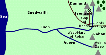
AdornRiver in Rohan. The Adorn flowed northwest from its source in the White Mountains to join the River Isen. Together the Adorn and the Isen formed the far western boundary of Rohan.Freca had a stronghold at the source of the Adorn and lands on both sides of the river. He was a Man of Rohan who claimed descent from King Freawine but was also said to have Dunlendish blood. After Freca was slain by Helm Hammerhand, the land between the Adorn and the Isen was occupied by Dunlendings. This land was reclaimed for Rohan by King Folcwine but the people who lived there were of mixed blood and their loyalty to Rohan was tenuous. During the War of the Ring, many of them joined the forces of Saruman. Names &
Etymology:
Sources:
|
Map
of the Adorn and Isen
 |
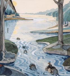
Beren and Luthien came to live on Tol Galen after they were returned to life from the Halls of Mandos around 469 of the First Age. The area became known as the Land of the Dead that Live. Their son Dior was born there in 470. Dior had a house near Lanthir Lamath and he named his daughter Elwing meaning "Star-spray" after the starlight shining in the waterfall on the night of her birth. Dior went to Doriath around 503 and Beren and Luthien died soon afterwards.
Names &
Etymology:
The name Adurant means "double
stream" in reference to the way it branched around Tol Galen. The word
adu
means "double" in Ilkorin, an early form of Elvish, and rant means
"course, riverbed" in Sindarin.
Sources:
The Silmarillion:
"Of Beleriand and Its Realms," p. 123; "Of the Fifth Battle," p. 188; "Of
the Ruin of Doriath," p. 234; Index, entry for Adurant; "Appendix
- Elements in Quenya and Sindarin Names," entry for rant
The History
of Middle-earth, vol. V, The Lost Road and Other Writings: "The Etymologies,"
entries for AT(AT) and RAT
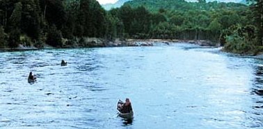
Anduin, The Great River |
The
Anduin in the New Line film
|
 Longest
river in Middle-earth. The Anduin flowed from north to south for over 1,100
miles. The Great River passed through Wilderland
east of the Misty Mountains for much
of its journey, and then passed the realms of Rohan,
Gondor,
and Mordor before emptying into the Bay
of Belfalas at the Mouths of the Anduin.
Longest
river in Middle-earth. The Anduin flowed from north to south for over 1,100
miles. The Great River passed through Wilderland
east of the Misty Mountains for much
of its journey, and then passed the realms of Rohan,
Gondor,
and Mordor before emptying into the Bay
of Belfalas at the Mouths of the Anduin.
The source of the Anduin was the River Langwell, which came down from the Misty Mountains in the far north of Middle-earth. The Langwell was joined by another small river called the Greylin from the Grey Mountains. The Anduin began at the juncture of the Langwell and the Greylin.
A number of other rivers joined the Anduin farther downstream. The Rushdown, Gladden, Silverlode, Limlight, and Entwash all flowed into the Great River from the Misty Mountains. In the south, the Erui and Celos came down from the White Mountains to join the Anduin. Only two rivers flowed into the Anduin on the eastern side: the Morgulduin and the Poros, which both began in the Mountains of Shadow on the border of Mordor.
The lands on either side of the Great River were called the Vales of the Anduin. Hobbits were believed to have once lived in the upper Vales of the Anduin in Wilderland until around 1050 of the Third Age, when the growing shadow in Mirkwood caused them to migrate across the Misty Mountains to Eriador. A group of Hobbits of the Stoor branch later returned to the Vales of the Anduin around 1356, but they eventually dwindled away.
Men also lived in the Vales of the Anduin in Wilderland, including the Eotheod - the ancestors of the Rohirrim. The Eotheod first came to dwell between the Gladden River and the Carrock on the west side of the Anduin in 1856, and in 1977 they relocated north to live near above the source of the Anduin. The Beornings - who were led by the skinchanger Beorn and his descendants - lived in the Vales of the Anduin near the Carrock in the later part of the Third Age.
The Carrock was a great peak of rock that rose out of the waters of the Anduin. A ford composed of stepping stones led to the Carrock from the eastern riverbank. About 25 miles south of the Carrock, the Old Forest Road between Mirkwood and the High Pass of the Misty Mountains crossed the Anduin at the Old Ford. At the end of the Second Age there was a bridge across the Anduin at this point which was used by the armies of the Last Alliance, but by the late Third Age the bridge was gone.
The Anduin then ran swiftly until it reached the marshland called the Gladden Fields which was located where the River Gladden joined the Anduin. It was there, in the year 2 of the Third Age, that Isildur perished and the One Ring was lost. The Ring lay at the bottom of the Anduin for over 2,000 years. In 2463, the Ring was found by Deagol, who was fishing with his friend Smeagol. They were of Hobbit-kind, descended from the Stoors who had settled in the Vales of the Anduin.
 The
Anduin flowed swiftly past Lothlorien and
then entered a region of low flatlands. The Wold
of Rohan was on the western side of the River. At this point, there were
two great bends in the River called the North Undeep and the South Undeep.
The Anduin had many shallows and wide shoals in this region and was relatively
easy to cross.
The
Anduin flowed swiftly past Lothlorien and
then entered a region of low flatlands. The Wold
of Rohan was on the western side of the River. At this point, there were
two great bends in the River called the North Undeep and the South Undeep.
The Anduin had many shallows and wide shoals in this region and was relatively
easy to cross.
South of the Undeeps in the Emyn Muil was Sarn Gebir - a stretch of stone spikes and rocky rapids about a mile long. Sarn Gebir was dangerous and virtually impossible for boats to navigate. There was narrow, swift central channel in which highly skilled boaters could try their luck. On the western bank of the Sarn Gebir there was a portage-way - a path by which boats could be carried past the rapids.
Past Sarn Gebir the Anduin was navigable but swift. The River narrowed and the banks rose to high cliffs. The two great statues called the Argonath stood on either side of the Anduin, at one time marking the northern boundary of Gondor. Beyond the Argonath, the high banks formed a narrow chasm that the River passed through before it widened to form the lake called Nen Hithoel. The island of Tol Brandir stood in the waters at the southern end of Nen Hithoel. The River then descended over the great Falls of Rauros. The North Stair was carved into the western bank to provide a portage-way past the Falls.
Beneath the Falls of Rauros, the Anduin was joined by the Entwash, forming the marshland called the Wetwang. In this region, the Anduin became sluggish and divided and was difficult to navigate by boat. The course of the River curved eastward at this point.
Farther downstream was Cair Andros. This large island made a convenient crossing point on the River. As such, it was fortified by Gondor as a defense against the forces of Mordor on the eastern side of the Anduin.
Along the lower Anduin, the Men of Gondor built several towns. The great city of Osgiliath - once the capital of Gondor - stood half on one side of the Anduin, and half on the other. Several bridges connected the two halves of the city, those these were later destroyed. When Osgiliath was abandoned, the capital was moved to Minas Tirith on the west side of the Anduin. There was a dock area called the Harlond on the river just outside Minas Tirith. The port city of Pelargir was 126 miles downstream from Minas Tirith on the western bank.
The lower course of the Anduin curved westward to the Bay of Belfalas. There it broke up into many streams and formed the great delta called the Ethir Anduin, or Mouths of the Anduin. Fisherfolk lived in this region, known as the Ethir, and people there were knowledgeable about the Sea. The island of Tolfalas was located in the Bay just beyond the Mouths of the Anduin.
The Anduin was a major route for trade and transportation. During the early days of Gondor, ships carried people and trade goods up and down the Anduin from Wilderland in the north to the Bay of Belfalas in the south. As Gondor's power waned and the threat from Sauron's forces increased, traffic on the river decreased and few if any boats came downriver from the north. But the Anduin remained an important route connecting Minas Tirith with the fiefdoms of southern Gondor.
The Anduin formed a natural line of defense between the lands of Gondor and Rohan west of the River and their enemies who lived in the east. For the most part, the defense of the River crossing was successful, but not always. In 2510, an army of Easterlings crossed the shallows of the Undeeps on rafts and attacked Gondor. The Men of the Eotheod came to the aid of Gondor at the Battle of the Field of Celebrant and were given the land of Rohan as a reward.
 During
the War of the Ring at the end of the
Third Age, Gondor was threatened by both the forces of Sauron east of the
Anduin and the fleets of the Corsairs from Umbar
south of the Bay of Belfalas. Boromir and Faramir
successfully defended the River crossing at Osgiliath on June 20, 3018,
though the Nazgul came across in secret to hunt
for the Ring-bearer.
During
the War of the Ring at the end of the
Third Age, Gondor was threatened by both the forces of Sauron east of the
Anduin and the fleets of the Corsairs from Umbar
south of the Bay of Belfalas. Boromir and Faramir
successfully defended the River crossing at Osgiliath on June 20, 3018,
though the Nazgul came across in secret to hunt
for the Ring-bearer.
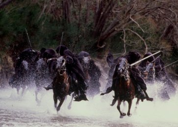
The Fellowship set out by boat down the Anduin from Lothlorien on February 16, 3019. They used the portage-way to carry their boats past the rapids of Sarn Gebir. They arrived at Nen Hithoel on February 25 and camped on the western shore at the foot of Amon Hen. The next day the Fellowship was broken and Boromir was killed by Uruk-hai. His body was placed in a boat which went over the Falls of Rauros and continued downriver to the Sea. The funeral boat was seen by Boromir's brother Faramir on February 29.
On March 10, a force from Mordor captured Cair Andros and crossed the River into Gondor north of Minas Tirith. Another force led by the Lord of the Nazgul crossed the Anduin at Osgiliath on March 12 and began to lay siege to Minas Tirith. But the next day, Aragorn led the Dead to Pelargir and defeated the Corsairs, who had captured the port city and were preparing to attack Minas Tirith. Aragorn used the Corsairs' ships to sail up the Anduin to Minas Tirith, arriving in time to help win the Battle of the Pelennor Fields on March 15.
Names &
Etmology:
The name Anduin means "long
river" from an or and meaning "long" and duin meaning
"river." The Anduin was called the
Great River in the Common
Speech, or sometimes simply the River. The River was also sometimes
referred to as Anduin the Great. The Anduin was called the Langflood,
or "Long River." by the Eotheod - the ancestors of the Rohirrim.
The Vales of the Anduin refers to the river valley along the Anduin; the word vale is another word for "valley."
Ethir Anduin means "Mouths of the Anduin." The word ethir means "mouth of a river" from ed meaning "forth, out" and sîr meaning "river."
Sarn Gebir means "stone spikes" from sarn meaning "stone" and gebir from cebir meaning "stakes."
Sources:
Map of
Middle-earth by Christopher Tolkien
The Hobbit: "Queer Lodgings," 123-25, 144-45
The Fellowship of the Ring: "Prologue - Concerning Hobbits," p. 12; "Concerning Pipe-weed," p. 18; "The Shadow of the Past," p. 61-62; "The Council of Elrond," p. 256-59, 264, 267, 281; "The Ring Goes South," p. 288, 294-95; "Lothlorien," p. 349, 355, 361, 363, 366; "Farewell to Lorien," p. 383-84, 387, 389-90, 393-95; "The Great River," passim; "The Breaking of the Fellowship," p. 411-12, 416-17, 422-23
The Two Towers: "The Departure of Boromir," p. 17-21; "The Riders of Rohan," p. 40; "The Uruk-hai," p. 49, 55; "Treebeard," p. 79; "The Black Gate Is Closed," p. 249; "Of Herbs and Stewed Rabbit," p. 258, 267; "The Window on the West," p. 274-76, 281; "The Forbidden Pool," p. 293; "Journey to the Cross-Roads," p. 306; "The Stairs of Cirith Ungol," p. 316
The Return of the King: "Minas Tirith," p. 22, 31, 36-38, 43; "The Siege of Gondor," p. 91; "The Battle of the Pelennor Fields," p. 122-23; "The Pyre of Denethor," p. 129; "The Last Debate," p. 149-54; "The Black Gate Opens," p. 159-60, 162, 166; "The Field of Cormallen," p. 231, 233-35; "The Steward and the King," p. 249
Appendix A of The Lord of the Rings: "Gondor and the Heirs of Anarion," p. 324-29, 334-36; "The House of Eorl," p. 345
Unfinished Tales: "The History of Galadriel and Celeborn - Appendix C: The Boundaries of Lorien," p. 260; "The Disaster of the Gladden Fields," passim; "Cirion and Eorl," p. 288-89, 295; "The Hunt for the Ring," p. 339; Index, entry for Sarn Gebir
The Silmarillion: "Of the Coming of the Elves," p. 54; "Of the Sindar," p. 94; "Akallabeth," p. 267; "Of the Rings of Power and the Third Age," p. 290-91, 293, 295, 297-98, 301-2; "Appendix - Elements in Quenya and Sindarin Names," entries for an(d),duin and sarn
The History of Middle-earth, vol. V, The Lost Road and Other Writings: "The Etymologies," entry for ED
Ascar |
Map
of the River Ascar
|
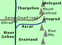 One
of the Seven Rivers of Ossiriand. The
Ascar formed the northern border of Ossiriand, a region in East Beleriand.
The region of Thargelion was north of the Ascar.
One
of the Seven Rivers of Ossiriand. The
Ascar formed the northern border of Ossiriand, a region in East Beleriand.
The region of Thargelion was north of the Ascar.
The Ascar began in the Blue Mountains and flowed westward into the Gelion. The Ascar was the northernmost of the Gelion's six tributaries. The Dwarf-road from Belegost and Nogrod ran along the northern bank of the Ascar and crossed the Gelion at Sarn Athrad.
In 375 of the First Age, the Men called the Haladin who lived in Thargelion were attacked by Orcs. Haldad led the Haladin into the angle of land formed by the Ascar and the Gelion and he built a stockade between the two rivers. The Haladin were besieged by Orcs and Haldad and his son Haldar were killed.
The Haladin ran out of food and some of them drowned themselves in the rivers. Just as the Orcs broke through the stockade, Elves led by Caranthir came to the rescue and drove the Orcs into the rivers. Afterwards, Haldad's daughter Haleth led her people away from Thargelion.
In 503, Dwarves from Nogrod sacked the halls of Menegroth in Doriath. On the way home with the treasure they were ambushed at Sarn Athrad by Green-elves of Ossiriand led by Beren and Dior. After the Dwarves were slain or driven away, the treasure was sunk to the bottom of the Ascar and the river became known as Rathloriel, the Goldenbed.
Beleriand was destroyed in the War of Wrath and the Ascar no longer existed after the end of the First Age.
Names &
Etymology:
The name Ascar means "rushing,
impetuous" in Sindarin. It was later named Rathlóriel meaning
"golden riverbed" from rath meaning "course, riverbed" and gloriel
meaning "golden."
Sources:
The Silmarillion:
"Of the Sindar," p. 92; "Of Beleriand and Its Realms," p. 123-24; "Of the
Coming of Men into the West," p. 140, 146; "Of the Ruin of Doriath," p.
235; Index, entry for Ascar
The History
of Middle-earth, vol. V, The Lost Road and Other Writings: "The Etymologies,"
entries for LAWAR, RAT, and SKAR
The History
of Middle-earth, vol. XI, The War of the Jewels: "The Later Quenta
Silmarillion," p. 227; "The Tale of Years," p, 347-53
Once past the Stone of Erech, the Blackroot flowed southwestward and then curved southeastward to join the Ringlo. The port of Edhellond was located near the juncture of the Blackroot and the Ringlo. The Blackroot emptied into Cobas Haven on the Bay of Belfalas.
On March 8, 3019 of the Third Age, Aragorn and the Grey Company emerged from the Paths of the Dead alongside the Blackroot River followed by the Dead.
Names &
Etymology:
The Blackroot was so named
because its source was in the dark caverns of the Dead. The river was called
Morthond
in Sindarin, meaning "Blackroot" from mor meaning "black" and thond
meaning "root."
Sources:
The Return
of the King: "The Passing of the Grey Company," p. 62
Appendix
E of The Lord of the Rings: "Writing and Spelling," p. 393
Unfinished
Tales: "The History of Galadriel and Celeborn," p. 247, 255 note 18
The History
of Middle-earth, vol. VII, The Treason of Isengard: "The First Map,"
p. 312
"Nomenclature
of The Lord of the Rings," entry for Blackroot Vale
"The Rivers
and Beacon-hills of Gondor," by J.R.R. Tolkien, edited by Carl F. Hostetter,
commentary by Christopher Tolkien, in Vinyar Tengwar #42, July 2001,
p. 14
Sarn Ford was located on the Brandywine south of the Old Forest. The ford was a wide area of shingles, or small stones. A road that branched off the Greenway passed over Sarn Ford into the Shire.
The Great East Road crossed the Brandywine over the Bridge of Stonebows - also called the Brandywine Bridge - located at the northern border of Buckland. The bridge had been built at the height of the North-kingdom. Nearby, the Bridge Inn was a resting place for travelers.
Hobbits also used the Bucklebury Ferry to cross the river into Buckland. On the western bank, the Ferry crossing was in the Marish. There was a wooden landing stage where the Ferry could be docked. On the Buckland side, the Ferry crossing was near the town of Bucklebury. The Ferry itself was a large, flat boat that could be maneuvered across the river using long poles.
Around 1700 of the Second Age - long before the founding of the Shire - Sarn Ford was the site of a battle between the forces of Sauron and the combined forces of the Elves and the Men of Numenor. Sauron's forces were in retreat, and at Sarn Ford their numbers were further reduced. They were driven southeastward to Tharbad where they were finally defeated in the Battle of Gwathlo in 1701.
In the year 1601 of the Third Age, the Fallohide brothers Marcho and Blanco led a group of Hobbits from Bree west across the Brandywine. They had obtained permission from King Argeleb II at Fornost to settle the lands between the Brandywine and the Far Downs. This land became known as the Shire. Shire Reckoning began with the crossing of the Brandywine.
In 2340, Gorhendad Oldbuck crossed the Brandywine going the other way and settled in the lands between the river and the Old Forest. This area became known as Buckland and was the traditional home of the Brandybuck family, as the Oldbucks were renamed.
During the Fell Winter of 2911 (1311 S.R.), the Brandywine froze over and white wolves crossed into the Shire.
The Brandybucks sometimes went boating on the Brandywine. This practice stood Merry Brandybuck in good stead when the Fellowship traveled by boat down the Anduin. But boating was the cause of the deaths of Frodo Baggins' parents, who drowned in the Brandywine in 2980.
In the late Third Age, the Rangers of the North guarded the borders of the Shire, where the One Ring was hidden. Rangers were stationed at Sarn Ford, where the road from the Greenway entered the Shire. On September 22, 3018, the Rangers at the ford were slain or driven away by the Nazgul led by the Witch-king. Some of the Nazgul crossed the Brandywine and entered the Shire in search of the One Ring.
Frodo Baggins - the Ring-bearer - and his companions used the Bucklebury Ferry to cross the Brandywine on their way to Crickhollow in Buckland on September 25, 3018. When they reached the eastern bank, they saw Khamul, one of the Nazgul, on the western side lurking around the Ferry landing. The Nazgul was unable to follow them across and had to go north to the Brandywine Bridge.
When the Hobbits returned to the Shire, they found that great spiked gates had been erected on either end of the Brandywine Bridge. No one was allowed to cross the bridge between sundown and sunrise, but the four companions took no notice of that rule. Merry tore down the notice and he and Pippin climbed the gate. The Hobbits then crossed the river into the Shire and set about freeing their land from Saruman's minions.
Aragorn, King Elessar, came north in the year 15 of the Fourth Age. Since he had decreed that Men were not to enter the Shire, he met Merry Brandybuck, Sam Gamgee, and Peregrin Took at the Brandywine Bridge.
Names &
Etymology:
Also called the Baranduin
in Sindarin. The name Baranduin comes from the words baran
meaning "golden brown" and duin meaning "river." The old Hobbit
name for the river was Branda-nîn meaning "border water,"
but Hobbits also jokingly referred to the river as Bralda-hîm
meaning "heady ale."
The name Sarn Ford includes the Sindarin word sarn meaning "small stone." The full Sindarin translation is Sarn Athrad. The ford was so called because of the small stones in the riverbed there.
Sources:
The Fellowship
of the Ring: "Prologue: Concerning Hobbits," p. 13-14; "A Long-Expected
Party," p. 30-31; "A Conspiracy Unmasked," p. 108-9; "Strider," p. 184;
"The Ring Goes South," p. 301-2; "Farewell to Lorien," p. 384.
The Return
of the King: "The Scouring of the Shire," p. 277-79
Appendix
B of The Lord of the Rings: p. 372, 377-78
Appendix
F of The Lord of the Rings: p. 416
Unfinished
Tales: "The History of Galadriel and Celeborn," p. 239; "The Hunt for
the Ring," p. 341
The Silmarillion:
"Appendix - Elements in Quenya and Sindarin Names," entry for sarn
Atlas of
Middle-earth by Karen Wynn Fonstad, map of the Shire, p. 70-71
The Lord
of the Rings: A Reader's Companion by Wayne G. Hammond and Christina
Scull: "Strider," p. 163
Names &
Etymology:
The name Brilthor means "glittering
torrent" from the root ril meaning "glitter" and thor meaning
"come swooping down" and thorod meaning "torrent." The name may
be in the dialect of the Green-elves of Ossiriand.
Sources:
The Silmarillion:
"Of Beleriand and Its Realms," p. 123; Index entry for Brilthor
The History
of Middle-earth, vol. V, The Lost Road and Other Writings: "The Etymologies,"
entries for RIL and THOR
Gateway
to Sindarin by David Salo, p. 339
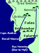
BrithonRiver in Beleriand. The Brithon was located in the coastal region of the Falas. It began in a small range of hills south of the Ered Wethrin and flowed southwestward to the Sea. The haven of Brithombar was at the mouth of the Brithon. The river emptied into an inlet bordered on the north by Cape Andras and on the south by another cape where the watchtower Barad Nimras stood.Names &
Etymology:
Sources:
|
Map
of the Brithon
 |
Bruinen (Loudwater) |
The
Nazgul at the Ford of Bruinen
in the New Line film |
 River
of Rivendell. The Bruinen was a loud, rushing
river that came down from the snows of the Misty
Mountains. About 50 miles from its source, the Bruinen was joined by
a mountain stream.
River
of Rivendell. The Bruinen was a loud, rushing
river that came down from the snows of the Misty
Mountains. About 50 miles from its source, the Bruinen was joined by
a mountain stream.
It is not entirely clear which of the the two forks was the main river and which was the tributary. A sketch drawn by Tolkien labelled the northern branch as the Bruinen, while the southern branch may have been called the Merrill. But from descriptions in the book it appears that the southern branch was the Bruinen, and that this was the river in the valley of Rivendell.
The Last Homely House where Elrond dwelled was on the northern bank of the river in the valley. A bridge spanned the river in front of the house, and just west of the bridge was a short waterfall.
The two branches merged west of Rivendell and just past their confluence was the Ford of Bruinen. The Great East Road crossed the river at the Ford. Beyond the Ford, there were rocky rapids. The Bruinen then continued southwestward, finally merging with the Hoarwell to form the Greyflood, which flowed to the Sea. The Bruinen was about 200 miles long.
The Bruinen was under the control of Elrond. He could command the waters to rise up against an enemy trying to enter Rivendell. Elrond was the bearer of the Elven-ring Vilya, which he used to defend Rivendell. It may be that he used Vilya to control the Bruinen, though this is never actually stated.
Frodo Baggins was pursued to the Ford of Bruinen by the Nazgul on October 20, 3018 of the Third Age. Frodo crossed the Ford on Asfaloth but felt compelled to stop on the other side. The Nazgul commanded him to give up the Ring, but Frodo refused. As soon as the Lord of the Nazgul started to cross the Bruinen, Elrond commanded the waters to rise up in a great flood, embellished by images of white horses created by Gandalf. The Nazgul were washed away. Eight of their horses were later found dead in the river, and the Nazgul themselves returned disembodied to Mordor.
Names &
Etymology:
Called the Loudwater in the
Common Speech. The name
Bruinen means "Loudwater," though the origin
of the element brui - apparently meaning "loud, noisy" - is not
clear. The element nen means "water." The Bruinen was also called
the River of Rivendell and the Ford of Bruinen was called
the Ford of Rivendell.
Sources:
Map of Middle-earth
by Christopher Tolkien
The Hobbit:
"A Short Rest," p. 57-60 and illustration of Rivendell
The Fellowship
of the Ring: "A Knife in the Dark," p. 200; "Flight to the Ford," p.
212-16, 220, 222, 225-27; "Many Meetings," p. 231-36, 238, 250; "The Council
of Elrond," p. 252, 262; "The Ring Goes South," p. 288, 294
The Return
of the King: "Homeward Bound," p. 268
The History
of Middle-earth, vol. VI, The Return of the Shadow: "From Weathertop
to the Ford," p. 201, 204-205
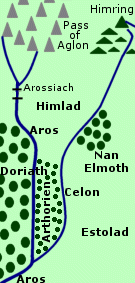
Celon |
Map
showing the Celon
|
 River
in East Beleriand. The Celon was a tributary of the Aros. It was a narrow
river with clear waters.
River
in East Beleriand. The Celon was a tributary of the Aros. It was a narrow
river with clear waters.
The Celon flowed southwest from the Hill of Himring and joined the Aros at the southeastern corner of Doriath. The East March of Doriath - called Arthorien or Radhrim - was in the angle between the Celon and Aros. After the First Battle in 1497 of the Years of the Trees, some Elves from Ossiriand settled in this part of Doriath.
North of Arthorien, where the distance between the rivers was wider, was the cool plain of Himlad. Celegorm and Curufin came to live in Himlad in the year 7 of the First Age.
On the east bank of the Celon was the small dark forest called Nan Elmoth. The Celon was narrow enough to cross at the northern edge of Nan Elmoth. Melian, a Maia from the Undying Lands, lived for a time in Nan Elmoth and Thingol encountered her there in 1130 of the Years of the Trees.
Eol the Dark Elf relocated to Nan Elmoth from Doriath after the Girdle of Melian was created following the First Battle. In 316 of the First Age, Aredhel of Gondolin wandered across the Celon into Nan Elmoth and Eol made her his wife. She fled from Nan Elmoth in 400 with her son Maeglin, but Eol followed them and both Aredhel and Eol were killed.
The open lands of Estolad lay east of the Celon south of Nan Elmoth. In 310, the Men of the House of Beor settled in Estolad on the east banks of the Celon. They were joined by the People of Marach in 313. Many of these Men left Estolad to settle elsewhere in Beleriand between 330 and 380. The People of Haleth lived in Estolad from 376 to 390 when they relocated to the Forest of Brethil.
Morgoth invaded Beleriand in the Battle of Sudden Flame in 455, and Celegorm and Curufin abandoned Himlad. For a time after the battle, Orcs continued to come down the Celon into East Beleriand.
The Celon ceased to exist when most of Beleriand sank beneath the Sea in the War of Wrath at the end of the First Age, though Himring remained above water as the island of Himling.
Names &
Etymology:
The name Celon means "stream
flowing down from heights" from the root kel meaning "go, run (especially
water)." In later writings, Tolkien decided that the name Celon was "too
hackneyed" and he replaced it with Limhîr meaning "clear,
sparkling river" from lim meaning "clear, sparkling" and hîr
from sîr meaning "river." The name Limhîr is also associated
with the Limlight.
Sources:
The Silmarillion:
"Of the Sindar," p. 96; "Of Beleriand and Its Realms," p. 124; "Of Maeglin,"
p. 132, 135; "Of the Coming of Men into the West," p. 142, 146; "Of the
Ruin of Beleriand," p. 156; Index, entry for Celon
Unfinished
Tales: "Narn I Hin Hurin," p. 77
The History
of Middle-earth, vol. V, The Lost Road and Other Writings: "The Etymologies,"
entry for KEL
The History
of Middle-earth, vol. XI, The War of the Jewels: "The Later Quenta
Silmarillion," p. 191; "Maeglin," p. 320, 336-37
Note:
On one map of Gondor included with
an early edition of
Unfinished Tales
the Celos is mistakenly shown as flowing into the Sirith from the east
rather than the west.
Names &
Etymology:
Also spelled (and pronounced) Kelos.
The Sindarin name Celos is dervied from the Quenya Kelussë
meaning "freshet, water falling out swiftly from a rocky spring."
Sources:
The Return
of the King: "The Last Debate," p. 151
Unfinished
Tales: "The History of Galadriel and Celeborn," p. 243; Index entry,
p. 426 (etymology)
The History
of Middle-earth, vol. VII, The Treason of Isengard: "The First Map,"
p. 322 note 9 (map error)
The town of Calembel was located on the eastern side of the Ciril. The road between Pelargir and Erech crossed the Ciril near Calembel. Aragorn and the Grey Company crossed the Ciril on March 9, 3019 of the Third Age, on their way to Pelargir.
Names &
Etymology:
Also spelled (and pronounced) Kiril.
The name Ciril is derived from kir meaning "cut."
Sources:
The Return
of the King: "The Passing of the Grey Company," p. 63; "The Last Debate,"
p. 151
"The Rivers
and Beacon-hills of Gondor," by J.R.R. Tolkien, edited by Carl F. Hostetter,
commentary by Christopher Tolkien, in Vinyar Tengwar #42, July 2001,
p. 13
The Deeping-stream then continued for a quarter mile to Helm's Dike, where it passed through a breach. The stream flowed through the Deeping-coomb and out into the Westfold Vale beyond. The Deeping-road from the Hornburg ran alongside the Deeping-stream.
During the Battle of Helm's Deep on the night of March 3-4, 3019 of the Third Age, Orcs crept through the culvert where the Deeping-stream passed under the Deeping-wall. Gamling led the Men of the Westfold to stop them and Gimli helped barricade the culvert. The Deeping-stream was blocked and began to form a pool behind the Deeping-wall. But later the Orcs returned and set off an explosive in the culvert, destroying the wall and unleashing the waters of the Deeping-stream. The Orcs invaded Helm's Deep but they were eventually defeated.
Names &
Etymology:
The Deeping-stream was so
named because it belonged to Helm's Deep.
Sources:
The Two
Towers: "Helm's Deep," p. 134-36, 139-42; "The Road to Isengard," p.
148, 151
"Nomenclature
of The Lord of the Rings," entry for Deeping Coomb
Names &
Etymology:
The name Dimrill means "dim
or shadowy stream." A rill is a small stream.
Sources:
The Fellowship
of the Ring: "Lothlorien," p. 347
"Nomenclature
of The Lord of the Rings," entry for Dimrill Dale
The Lord
of the Rings: A Reader's Companion by Wayne G. Hammond and Christina
Scull: "Lothlorien," p. 299
Beorn warned Thorin Oakenshield and Company to avoid touching the water. When they came to the Enchanted Stream, they saw a boat on the opposite bank that had most likely been left by the Wood-elves. The Dwarves got ahold of the boat using a rope and a hook and were able to cross the stream, but just as Bombur was disembarking he was startled by a deer and fell into the stream. He immediately fell into a deep sleep and did not awake for many days.
Sources:
The Hobbit:
"Queer Lodgings," p. 143; "Flies and Spiders," p. 153-56
The river then flowed through the Entwash Vale, where it broke up into many small streams before joining the Anduin. The land around the Mouths of the Entwash was marshy and the air was misty. In the spring thaw following the Long Winter of 2758-59 of the Third Age, there were great floods and the Entwash Vale had become a vast fen. On the other side of the Anduin lay the marshland known as the Wetwang. The Anduin was difficult to navigate in this region.
The Entwash could be crossed at a ford called the Entwade about 60 miles northeast of Edoras. The River Snowbourn flowed from the White Mountains into the Entwash east of Edoras. Thickets of willow trees grew around the juncture of the two rivers. Farther east, the Mering Stream came down from the mountains and merged with the Mouths of the Entwash.
The waters of the Entwash had special properties. When Merry Brandybuck and Pippin Took bathed their feet in its waters, they felt refreshed and their wounds were healed. The water from the springs of the Entwash was used by the Ents to make Ent-draughts, a drink that caused Merry and Pippin to grow taller.
Names &
Etymology:
Also called Onodlo in Elvish.
The Entwash got its name from the Ents who dwelled in Fangorn. The word wash is from the Old Englishwaesc meaning "flood water." The Sindarin name Onodló translates as "Entwash," from the word Onod meaning "Ent" and ló meaning "soaking wet, swampy, flood."
Sources:
The Fellowship
of the Ring: "Farewell to Lorien," p. 389-90; "The Great River," p.
405
The Two
Towers: "The Riders of Rohan," p. 23, 26, 29, 31-32, 39, 42; "The Uruk-hai,"
p. 62; "Treebeard," p. 64, 66, 71, 72-74; "The White Rider," p. 93, 107;
"The King of the Golden Hall," p. 111; "Flotsam and Jetsam," p. 175; "The
Window on the West," p. 275-76
The Return
of the King: "The Muster of Rohan," p. 78
Unfinished
Tales: "The History of Galadriel and Celeborn - Appendix D: The Port
of Lond Daer," p. 263 (definition of lo); "Cirion and Eorl," p.
300-301, 306, 318 note 46; "The Battles of the Fords of Isen," p. 367
"Nomenclature
of The Lord of the Rings," entry for Entwade, Entwash, Entwood
In 1447 of the Third Age, the Battle of the Crossings of Erui was fought between the forces of Eldacar - the rightful King of Gondor - and Castamir- the rebel who had usurped his throne. Many were killed in the battle including Castamir, and Eldacar reclaimed his throne.
Names &
Etymology:
The name Erui is composed
of er meaning "one, single, alone" and ui which is a common
adjectival ending in Sindarin. It was apparently so named because it had
no tributaries.
Sources:
Appendix
A of The Lord of the Rings: "Gondor and the Heirs of Anarion," p. 327
"The Rivers
and Beacon-hills of Gondor," by J.R.R. Tolkien, edited by Carl F. Hostetter,
commentary by Christopher Tolkien, in Vinyar Tengwar #42, July 2001,
p. 10
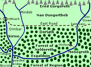
Esgalduin |
Map
of the Esgalduin
|
 River
of Doriath. The Esgalduin divided the Forest
of Neldoreth from the Forest of Region. It was a dark, enchanted river.
River
of Doriath. The Esgalduin divided the Forest
of Neldoreth from the Forest of Region. It was a dark, enchanted river.
The Esgalduin was a tributary of the Sirion. It began north of Doriath in the Ered Gorgoroth and was joined by a smaller mountain stream. The Esgalduin flowed south through the valley of Nan Dungortheb. East of the Esgalduin was the uninhabited region called Dor Dinen.
At the northern edge of Doriath, a stone bridge called Iant Iaur spanned the Esgalduin. The East Road crossed the river by way of the bridge. The road and the bridge were built in the time of peace before Morgoth returned to Middle-earth in 1495 of the Years of the Trees.
In northern Doriath, the Esgalduin cascaded over a steep falls into a dark valley. The Esgalduin continued southward through the woods and then curved westward to join the Sirion. The beech-woods of Neldoreth were north of the Esgalduin while the larger Forest of Region was to the south.
Menegroth was located at the bend in the river. The gates of Menegroth were in a hill on the southern bank. A bridge over the Esgalduin was the only way to reach the gates. The great beech-tree named Hirilorn was on the northern bank not far from the bridge.
The Esgalduin flowed into the Sirion near the western edge of Doriath. Across the Sirion was Nivrim, the West March - a small oak forest that was part of Doriath. There was a guarded bridge across the Sirion near its confluence with the Esgalduin.
The Esgalduin was almost entirely within the Girdle of Melian - the protective barrier around Doriath which Melian made in 1497 of the Years of the Trees. In 466 of the First Age, Carcharoth, the Wolf of Angband, came down from the source of the Esgalduin in Ered Gorgoroth and followed the river into Doriath. He was able to breach the Girdle because he had swallowed one of the Silmarils.
Carcharoth stopped to drink from the Esgalduin near the waterfall in northern Doriath, and the waters temporarily eased the burning pain of the Silmaril. Huan the Hound fought with Carcharoth by the river and the clamor of their battle caused rocks to fall and block the waterfall. Carcharoth was slain by Huan but not before he mortally wounded Huan and Beren.
In 502, King Thingol of Doriath was killed by Dwarves who coveted the Silmaril. Melian left Doriath and returned to the Undying Lands, and the Girdle of Melian was withdrawn. It was said that afterwards "Esgalduin the enchanted river spoke with a different voice" (Sil, p. 234). Doriath was ruined and abandoned in 506. At the end of the First Age, Beleriand was destroyed and the Esgalduin was no more.
Names &
Etymology:
The name Esgalduin means
"River under Veil" from esgal meaning "screen, hiding, roof of leaves"
and duin meaning "river." The name was originally intended to be
in the early Ilkorin language but was later interpreted as Sindarin.
Sources:
The Silmarillion:
"Of the Sindar," p. 93; "Of the Ruin of Beleriand," p. 121; "Of Maeglin,"
p. 132; "Of Beren and Luthien," p. 165, 184-85; "Of Turin Turambar," p.
218; "Of the Ruin of Doriath," p. 234; "Appendix - Elements in Quenya and
Sindarin Names," entries for duin and esgal
The History
of Middle-earth, vol. V, The Lost Road and Other Writings: "The Etymologies,"
entries for DUI and SKAL1
The History
of Middle-earth, vol. XI, The War of the Jewels: "The Grey Annals,"
p. 11, 94, 150-51; "The Later Quenta Silmarillion," p. 183 (map); "Maeglin,"
p. 331 (map), 332-35
Unfinished
Tales: "Narn I Hin Hurin," p. 74, 82, 120
Forest RiverRiver in Mirkwood. The Forest River began in the Grey Mountains and flowed southeast through Mirkwood to Long Lake. The Enchanted Stream was a tributary of the Forest River in the heart of Mirkwood. When the river emerged from the forest, it broke up into a hundred winding courses and the land on either side was full of marshes and pools. At the mouth of the river where it flowed into Long Lake there were stony cliffs on each side.After the Dwarves were forced out of the Lonely Mountain by Smaug, many roads in Wilderland fell into disuse or were damaged or destroyed by floods, earthquakes, and encroaching marshland. The Forest River became the only safe and reliable way eastward from Mirkwood. The river was guarded by the Elves of Mirkwood, though they had disputes with the Lake-men over the upkeep of the river and its banks. The Forest River was used to send goods between the Elven-king's Halls and Lake-town. Wine in barrels was one of the chief commodities transported on the river. A stream ran from under the Elven-king's Halls to join the Forest River. A wide bay in the north bank of the Forest River was used to collect the barrels to be tied together into rafts. Bilbo Baggins used the Forest River to help the Dwarves escape from the Elven-king's prison in September 2941 of the Third Age. He packed the Dwarves into empty barrels and rode one himself and they floated downstream to Lake-town. Sources:
|
The
Forest River by J.R.R. Tolkien
|
The Gelion was formed from two branches called the Little Gelion and the Greater Gelion. The Little Gelion was the western branch and it sprang from the Hill of Himring. To the east, the Greater Gelion was also split into two branches - one that came down from Mount Rerir and another that flowed from Lake Helevorn.
The Gelion flowed south from the confluence of the Little Gelion and Greater Gelion. East Beleriand lay west of the Gelion. East of the Gelion, for the first 120 miles of its course, was the region of Thargelion between the river and the Blue Mountains. South of Thargelion was Ossiriand.
Along the border between Thargelion and Ossiriand, the Ascar flowed from the Blue Mountains into the Gelion. The Ascar was one of six tributaries of the Gelion from Ossiriand. The other five were, from north to south: the Thalos, the Legolin, the Brilthor, the Duilwen, and the Adurant. Together the tributaries and the Gelion comprised the Seven Rivers of Ossiriand.
South of the Adurant, the Gelion began to curve westward. It flowed along the edge of the great forest of Taur-im-Duinath and then emptied into the Sea on the coast south of the Bay of Balar.
The main ford over the Gelion was Sarn Athrad, the Ford of Stones, just north of the Ascar. The Dwarf-road crossed the Gelion at Sarn Athrad and ran along the northern bank of the Ascar to the Dwarf cities of Belegost and Nogrod in the Blue Mountains. Sarn Athrad was also called Harathrad, the South Ford, or Athrad Daer, the Great Ford. There was another crossing called the Northern Ford or Little Ford near the confluence of the Little Gelion and the Great Gelion.
The waters of the Gelion were imbued with the power of Ulmo, Lord of Waters. He loved the Gelion second only to the Sirion out of all the rivers of Middle-earth. Around 1350 of the Years of the Trees, the Green-elves settled in Ossiriand and they were protected by the power of the Gelion.
In the year 7 of the First Age, the sons of Feanor came to East Beleriand. Maglor settled in the lands between the Little Gelion and the Greater Gelion which became known as Maglor's Gap. Maedhros lived on Himring, and Caranthir dwelled in Thargelion.
A group of Men known as the Haladin settled in southern Thargelion around 312. In 375, the Haladin were attacked by Orcs. Haldad led many of his people to a defensive position in the angle of land between the Ascar and the Gelion and they built a stockade between the two rivers. The Haladin were besieged and Haldad and his son Haldar were killed. Caranthir defeated the Orcs, and Haldad's daughter Haleth led the Haladin away from Thargelion.
During the Battle of Sudden Flame in 455, Glaurung led an army through Maglor's Gap and ravaged the lands between the Little Gelion and Greater Gelion. They continued their path of destruction into Thargelion and then they crossed the Gelion into East Beleriand. The enemy forces were finally stopped by Thingol near Doriath.
In 503, an army of Dwarves from Nogrod crossed the Gelion at Sarn Athrad. They attacked Doriath and stole the Nauglamir which was set with one of the Silmarils. On their way back to Nogrod, the Dwarves were ambushed at Sarn Athrad by Beren and the Green-elves of Ossiriand. Most of the Dwarves were slain. Beren claimed the necklace with the Silmaril, but the rest of the stolen treasures were sunk in the Ascar which became known as Rathloriel, the Goldenbed.
In the War of Wrath at the end of the First Age, most of Beleriand was drowned beneath the Sea. A portion of Ossiriand remained as the region of Lindon, but the Gelion no longer existed.
Names &
Etymology:
In one source (HoME
IV, p. 210), Tolkien equated the name Gelion with the
Old English word glæden meaning "iris," but this is not a
translation from Elvish. Tolkien was later unhappy with the etymology of
the name Gelion and considered changing it to Gelduin or
to Gevilon / Gevelon derived from the Dwarvish Gabilan
meaning "great river" with an alternate form Duin Daer meaning "great
river" in Sindarin from duin meaning "river" and daer meaning
"great."
(HoME XI, p. 336)
Sources:
The Silmarillion:
"Of the Coming of the Elves," p. 54; "Of Thingol and Melian," p. 55; "Of
the Sindar," p. 91-92, 96; "Of the Return of the Noldor," p. 112; "Of Beleriand
and Its Realms," p. 121-24; "Of the Coming of Men into the West," p. 140,
142, 146; "Of the Ruin of Beleriand," p. 153; "Of the Fifth Battle," p.
188; "Of the Ruin of Doriath," p. 232-35
The History
of Middle-earth, vol. IV, The Shaping of Middle-earth: "The Quenta,"
p. 210
The History
of Middle-earth, vol. XI, The War of the Jewels: "The Grey Annals,"
p. 5, 7, 13, 15, 45, 53, 105; "The Later Quenta Silmarillion," p. 183,
185, 190-91, 193, 195, 197, 206, 216, 218, 221; "Maeglin," p. 334-36, 338
note 8, 338-39 note 10; "The Tale of Years," p. 347, 349
Legend told that when the Elf-maiden Nimrodel became separated from her lover Amroth on their journey to the Elf-haven on the Bay of Belfalas, she came upon the Gilrain and her heart was lightened because it reminded her of the stream by which she dwelled in Lorien. She sat by the mere and fell into a long deep sleep. Amroth's ship was swept to Sea by a storm and he jumped overboard and drowned trying to return to find Nimrodel.
On March 11, 3019 of the Third Age, Lord Angbor of Lamedon and his Men fought at the fords on the Gilrain near Linhir against the Men of Umbar and Harad who had sailed up the river. Aragorn and the Grey Company arrived leading the Dead and Men on both sides of the battle fled, but Angbor was brave enough to remain. Aragorn and the Grey Company crossed the Gilrain driving their enemies before them and continued on to Pelargir.
Note:
There is some question about whether
it was the Gilrain or the Serni that flowed into the Bay of Belfalas after
they merged. Legolas described Linhir as being "above the mouth of the
Gilrain" (RotK, p. 151), which would
seem to indicate that the mouth of the Gilrain was on the Bay of Belfalas.
But the map and other sources such as Unfinished
Tales (p. 463-64) show that the Gilrain flowed into the Serni,
and the Serni in turn flowed into the Bay.
Names &
Etymology:
The element gil means "star,
shine." The element rain is derived from ran meaning "wander,
stray, go on uncertain course" in reference to the meandering portion of
the Gilrain where Nimrodel wandered.
Sources:
The Return
of the King:
"The Last Debate," p. 151
Unfinished
Tales: "The History of Galadriel and Celeborn: Amroth and Nimrodel,"
p. 242-43
The marshland called the Gladden Fields spread out around the lower courses of the Gladden River and across the Anduin. In ancient times, when the Silvan Elves first came to the region, there was a lake where the Anduin and the Gladden River merged, but over time the waters receded and the wetlands of the Gladden Fields were formed.
In the year 2 of the Third Age, Isildur was slain by Orcs in the Gladden Fields and the One Ring was lost in the waters for over two millennia. In 2463, the Ring was found by Deagol who was fishing with his friend Smeagol. Smeagol murdered Deagol and took the Ring for himself.
Deagol and Smeagol were descendants of a group of Hobbits of the Stoor branch who originally settled near the Gladden River around 1356. By the end of the Third Age, their settlements were gone.
Men had also dwelled in the Vales of the Anduin near the Gladden River. The ancestors of the Rohirrim, who were called the Eotheod, settled on the west side of the Anduin between the Gladden River and the Carrock around 1856. In 1977, the Eotheod relocated farther north to the source of the Anduin. Men also lived along the Anduin south of the Gladden, but by 2510 most of them had been driven away by raids of hostile Men from the East.
After the Council of Elrond in 3018, scouts set out to discover whether the Nazgul or other servants of Sauron were abroad. Some scouts went over the mountain pass near the Gladden and followed the river to the Gladden Fields. They crossed the Anduin and visited Rhosgobel, the home of Radagast the Wizard in Mirkwood, but he was not home.
Names &
Etymology:
The word gladden is from
the Anglo-Saxon glædene, meaning "iris," referring to the
yellow irises that grew in the Gladden Fields. The Sindarin name of the
river was Sîr Ninglor, meaning "golden river." The word sîr
means "river" and ninglor means "golden waters" from nin
meaning "waters" and
glor or glaur meaning "gold."
Sources:
The Fellowship
of the Ring: "The Shadow of the Past," p. 61-63; "The Ring Goes South,"
p. 287
Appendix
A of The Lord of the Rings: "The North-kingdom and the Dunedain," p.
321; "The Stewards," p. 334; "The House of Eorl," p. 344; "Durin's Folk,"
p. 355
Appendix
F of The Lord of the Rings: "The Languages and Peoples of the Third
Age," p. 405, 407
Unfinished
Tales: "Cirion and Eorl," p. 289; "The Disaster of the Gladden Fields,"
passim (see especially note 13); "The Hunt for the Ring," p. 337, 339,
343
The Silmarillion:
"Appendix - Elements in Quenya and Sindarin Names," entry for sir
The History
of Middle-earth, vol. V, The Lost Road and Other Writings: "The Etymologies,"
entries for GLAW(R) and NEN
Letters
of J.R.R. Tolkien: Letter #297
Glanduin |
Map
of the Glanduin
|
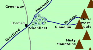 River
on the southern border of Eriador. The Glanduin
began in the Misty Mountains south of
Moria
and flowed westward. Sirannon, the Gate-stream
of Moria, may have been a tributary that joined the Glanduin. The Glanduin
merged with the Hoarwell to form the Greyflood,
which flowed into the Sea.
River
on the southern border of Eriador. The Glanduin
began in the Misty Mountains south of
Moria
and flowed westward. Sirannon, the Gate-stream
of Moria, may have been a tributary that joined the Glanduin. The Glanduin
merged with the Hoarwell to form the Greyflood,
which flowed into the Sea.
The upper course of the Glanduin ran swiftly. The river could be crossed at an old ford. West of the ford was a waterfall. Beyond the falls, the lower courses of the Glanduin became a marshland that was called Swanfleet because it was inhabited by swans. The city of Tharbadwas located on the Greyflood near the point where the Glanduin and Hoarwell merged.
The Glanduin and the Greyflood formed the southern border of Eriador. In the Second Age, the Glanduin was also the southern boundary of the Elvish realm of Eregion. South of the Glanduin was Dunland.
Frodo Baggins and his companions crossed the Glanduin on their way home in September 3019 of the Third Age.
Names &
Etymology:
The name Glanduin means "border
river" from glan meaning "border" and duin meaning "river."
The name was usually applied only to the swift upper course of the river,
while the marshy lower course was called Swanfleet. It was also
called the Swanfleet river because it was the river that fed the
marshlands of Swanfleet.
Sources:
The Return
of the King: "Many Partings," p. 263
Appendix
A of The Lord of the Rings: "Eriador, Arnor, and the Heirs of Isildur,"
p. 319
Unfinished
Tales: "The History of Galadriel and Celeborn - Appendix D: The Port
of Lond Daer," p. 261-65
The city of Tharbad was located at the juncture of the Hoarwell and the Glanduin. A bridge originally spanned the Greyflood there, and the North-South Road passed over it.
The Greyflood flowed southwestward to the Sea. The port of Lond Daer was near the seacoast on the southern bank of the Greyflood. Lond Daer was founded in the early Second Age by Aldarion of Numenor.
Originally, the land on both sides of the Greyflood was covered by a great forest, which grew down to the riverbanks and cast deep shadows on the water. But the Numenoreans cut down many of the trees. They floated the timber down the Greyflood to Lond Daer and used the wood to build ships. In time, most of the woods were destroyed, and open grasslands lay on either side of the Greyflood.
In 1701 of the Second Age, the Battle of the Gwathlo was fought along the Greyflood between the forces of Sauron and an army of Numenoreans who landed at Lond Daer. Sauron's forces were defeated. Sauron himself escaped and retreated to Mordor.
In the Third Age, the Greyflood formed part of the southern border of the North-kingdom of Arnor. The river was also briefly the northwestern boundary of Gondor at the height of its power under Hyarmendacil I (1015-1149), though later Enedwaith was no longer considered part of Gondor.
Tharbad was an important river port. People traveling from Gondor to Arnor often sailed by Sea to the mouth of the Greyflood and then upriver to Tharbad where they continued by land.
The Greyflood flooded during the spring thaw of 2912 following the Fell Winter. Tharbad was ruined and deserted. The Bridge of Tharbad collapsed and the crossing - though still slow and shallow - became dangerous because of the ruins in the water. When Boromir traveled to Rivendell in 3018, he lost his horse while crossing the Greyflood.
Names &
Etymology:
The original Sindarin name given
to the river was Gwaithir meaning "River of Shadow" from gwath
meaning "shadow" and hir from sir meaning "river." The name
referred to the shadows cast on the river by the dense forest on its banks.
Later when the Numenoreans discovered the marshy Swanfleet at the source of the river they changed the name to Gwathló - "the shadowy river from the fens." The element lô is from loga meaning "wet, soaked, swampy."
The name of the river in Adunaic – the language of Numenor – was Agathurush, meaning "flood under shadow." The Common Speech name was Greyflood.
Sources:
The Fellowship
of the Ring: "Flight to the Ford," p. 212; "The Ring Goes South," p.
287-88, 298; "Farewell to Lorien," p. 390
The Return
of the King: "Many Partings," p. 263; "Homeward Bound," p. 272
Appendix
A of The Lord of the Rings: "Eriador, Arnor and the Heirs of Isildur,"
p. 319; "The North-kingdom and the Dunedain," p. 320; "Gondor and the Heirs
of Anarion," p. 325
Unfinished
Tales: "Aldarion and Erendis," p. 175-76, 200, 206; "The History of
Galadriel and Celeborn," p. 239-40, 261-65; "The Battles of the Fords of
Isen," p. 370; "The Druedain," p. 383
The Silmarillion:
"Appendix - Elements in Quenya and Sindarin Names," entries for gwath
and sir
"The Rivers
and Beacon-hills of Gondor," by J.R.R. Tolkien, edited by Carl F. Hostetter,
commentary by Christopher Tolkien, in Vinyar Tengwar #42, July 2001,
p. 8-10
Between 1977 and 2510 of the Third Age, the Eotheod lived north of confluence of the Greylin and Langwell and they had a fortified burg called Framsburg where the two rivers merged. The Eotheod relocated after 2510 and became the people of Rohan.
Names &
Etymology:
The Greylin was named by
the Eotheod. The first element is a reference to the river's source in
the Grey Mountains, while the second element is derived from the Anglo-Saxon
hylnnmeaning
"torrent" or "the noisy one."
Sources:
Unfinished
Tales: "Cirion and Eorl," p. 295, 313 note 20, and Index entry p. 442
The Lord
of the Rings: A Reader's Companion by Wayne G. Hammond and Christina
Scull: "The Maps of The Lord of the Rings," p. lxv
The River Harnen was the southern border of Gondor at the height of its power under King Hyarmendacil I, who crossed the Harnen in 1050 of the Third Age and defeated the Men of Harad.
Names &
Etymology:
The name Harnen means "south
water" from harad meaning "south" and nen meaning "water."
Sources:
Map of
Middle-earth by Christopher Tolkien
Appendix
A of The Lord of the Rings: "Gondor and the Heirs of Anarion," p. 325
The History
of Middle-earth, vol. V, The Lost Road and Other Writings: "The Etymologies,"
entries for KHYAR and NEN
The Hoarwell then continued south and was joined by the Loudwater. The triangular-shaped land between these two rivers was called the Angle. The Hoarwell bent southwestward to the town of Tharbad on the Greenway. Just above Tharbad, the Hoarwell was joined by the Glanduin and the two rivers merged to form the Greyflood, which flowed southwest into the Sea.
Around the year 1150 of the Third Age, the Fallohides crossed the Misty Mountains in the north and came down the Hoarwell into Eriador. The Stoors crossed the mountains at the Redhorn Gate and settled in the Angle between the Hoarwell and the Loudwater. At this time the Angle was part of the Kingdom of Rhudaur and the Hoarwell formed part of the boundary between Rhudaur and Cardolan.
By 1356, Rhudaur had fallen under the influence of the Witch-king of Angmar and the Stoors fled. The Kingdoms of Arthedain and Cardolan defended a frontier along the Weather Hills, the Great East Road, and the lower Hoarwell, but in 1409 the Witch-king crossed the Hoarwell and defeated them. The Witch-king was finally driven from the north in 1975.
One night in late May of 2941, Bilbo Baggins and the Dwarves of Thorin's company crossed the Last Bridge over the Hoarwell, which was swollen with rains from the hills and mountains in the north. It was that same night that they encountered the Trolls Tom, Bert, and William in the Trollshaws.
In October of 3018, Gandalf travelled up the Hoarwell after he was attacked by Nazgul on Weathertop and he passed through the Ettenmoors and came to Rivendell from the north. On October 11, the Elf-lord Glorfindeldrove three Nazgul from the Last Bridge and left a green stone on the bridge as a token. Two days later,Strider found the stone and led Frodo Baggins and the Hobbits safely across the Hoarwell. In November and December, scouts were sent from Rivendell up the Hoarwell to its springs in the Ettenmoors, but they found no trace of the Nazgul there.
Names &
Etymology:
Also called the Mitheithel
in Sindarin. The word Mitheithel comes from the words mith
meaning "grey" and eithel meaning "spring, well." The word hoar
means "grey."
Sources:
The Hobbit:
"Roast Mutton," p. 41
The Annotated
Hobbit: "Roast Mutton, p. 66-67 and note 9
The Fellowship
of the Ring: "Prologue: Concerning Hobbits," p. 12; "Flight to the
Ford," p. 212-13; "The Council of Elrond," p. 278; "The Ring Goes South,"
p. 287
Appendix
A of The Lord of the Rings: "The North-kingdom and the Dundedain,"
p. 320-21
Appendix
B of The Lord of the Rings: "The Tale of Years," p. 366-67
History
of Middle-earth, vol. VI, The Return of the Shadow: "From Weathertop
to the Ford," p. 205; "The Ring Goes South," p. 432 note 3 (Hoardale references)
Isen |
Map
of the River Isen
|
River
of Isengard. The River Isen began at the southern
end of the Misty Mountains, probably
on the slopes of Methedras. The
river was fed by many mountain streams and springs and it was swift and
strong as it flowed southward through the Wizard's
Vale past Isengard on its western bank. There was a bridge spanning
the river about a mile from Isengard. A road ran along the western side
of the river from Isengard.
As it emerged from the valley and continued across flatlands of the Gap of Rohan, the Isen became broader, shallower and slower. At the Fords of Isen, the river could be crossed by large groups of people and horses. There was a small island at the middle of the Fords. Three rows of stepping stones led to the island from each bank with fords for horses between them. From the east bank of the Fords the Great West Road ran through Rohan to Gondor, and from the west bank the North-South Road ran to Arnor.
Just south of the Fords of Isen, the river curved westward and flowed along the southern boundary of Enedwaith. It was joined by the Adorn, which sprang from the White Mountains to the south. The Isen became deep and rapid again as it flowed down long slopes to the coastlands and into the Sea.
The Isen and the Adorn formed the western border of Rohan, and the Fords of Isen were of strategic importance for Rohan's defense. Men from Dunland invaded Rohan in 2758 of the Third Age by defeating the Rohirrim led by King Helm in a battle at the Fords of Isen.
There were two Battles of the Fords of Isen during the War of the Ring between the Rohirrim and the forces of Saruman from Isengard. At the First Battle on February 25, 3019, King Theoden's son Theodred was killed. He was buried on the island in the middle of the Fords. The Second Battle was fought on March 2. The Rohirrim were again defeated and Saruman's forces proceeded to Helm's Deep.
The Ents led by Treebeard used the waters of the Isen to destroy Isengard. They began damming the river on March 3, and at midnight on March 4 they broke the dams and diverted the floodwaters into the circle of Isengard. The waters poured into the underground tunnels, quenching the fires of Saruman's forges and washing out the filth. The Ents then returned the Isen to its normal course.
Names &
Etymology:
The name Isen means "iron"
in the language of Rohan, from the Old English word ísen.
The Sindarin name was Sîr Angren, from sîr meaning
"river" and angren meaning "iron."
The Fords of Isen were also called the Crossings of Isen. In Sindarin, they were called Athrad Angren - sometimes written in the plural form as Ethraid Engrin.
Sources:
The Fellowship
of the Ring: "A Journey in the Dark," p. 309; "Farewell to Lorien,"
p. 390
The Two
Towers: "Helm's Deep," p. 131-34; "The Road to Isengard," p. 150, 154-61;
"Flotsam and Jetsam," p. 171, 174-80; "The Palantir," p. 194, 201
The Return
of the King: "The Passing of the Grey Company," p. 46; "Many Partings,"
p. 260; "Homeward Bound," p. 272
Appendix
A of The Lord of the Rings: "The Stewards," p. 334; "The House of Eorl,"
p. 345, 347, 349-51
Appendix
B of The Lord of the Rings: "The Tale of Years," p. 374
Unfinished
Tales: "Aldarion and Erendis," p. 175, 214 note 6; "The History of
Galadriel and Celeborn," p. 262-64; "Cirion and Eorl," p. 303, 305-6, 314
note 32, 318 note 47; "The Battles of the Fords of Isen," passim
Between 1977 and 2510 of the Third Age, the Langwell was the southern boundary of the land of the Eotheod - who later settled in Rohan. There was a fortified burg called Framsburg at the juncture of the Langwell and Greylin.
Names &
Etymology:
The word lang is a variant
of "long" and the word well is used to mean "spring, source." The
Langwell
was
so called by the Eotheod because it was the source of the Anduin, which
they named the
Langflood, or "Long River."
Sources:
Map of Middle-earth
by Christopher Tolkien
Unfinished
Tales: "Cirion and Eorl," p. 295 and Index entry for Langwell
The Lord
of the Rings: A Reader's Companion by Wayne G. Hammond and Christina
Scull: "The Maps of The Lord of the Rings," p. lxv
Names &
Etymology:
The name Lefnui means "fifth."
The river was so named because it was the fifth river or river system in
southern Gondor after the Erui, the Sirith-Celos,
the
Serni-Gilrain, and the
Morthond-Ciril-Ringlo.
Sources:
Unfinished
Tales: "The History of Galadriel and Celeborn," p. 263; "The Druedain,"
p. 383-84
"The Rivers
and Beacon-hills of Gondor," by J.R.R. Tolkien, edited by Carl F. Hostetter,
commentary by Christopher Tolkien, in Vinyar Tengwar #42, July 2001,
p. 14-15
Names &
Etymology:
The name Legolin contains
the word legol meaning "nimble, active, running free" in the early
Elvish language Ilkorin.
Sources:
The Silmarillion:
"Of Beleriand and Its Realms," p. 123
The History
of Middle-earth, vol. V, The Lost Road and Other Writings: "The Etymologies,"
entry for LEK
The land of Rohan was originally a part of Gondor called Calenardhon. The Men of Gondor built a bridge over the upper part of the Limlight. Forts were built on the west bank of the Anduin south of the Limlight during the time of Romendacil II. Defenses were also maintained north of the Limlight at the point where it joined the Anduin. The Anduin was wide and shallow there and was vulnerable to an invasion from the East.
In 2510 of the Third Age, a group of Men from Rhun called the Balchoth invaded Calenardhon by crossing the Anduin south of the Limlight. The Balchoth forced the Northern Army of Gondor led by Cirion to retreat northward across the Limlight into the Field of Celebrant. Defeat seemed imminent, but then the Eotheod led by Eorl the Young arrived. The Eotheod crossed into Calenardhon and over the Limlight to attack the Balchoth from the rear.
The Balchoth were defeated in the Battle of the Field of Celebrant. The Eotheod drove the Balchoth back across the Limlight and hunted them down in Calenardhon. Cirion then gave the land of Calenardhon to the Eotheod and it became Rohan.
Names &
Etymology:
The meaning of the name Limlight
is uncertain. It appears to be a partial translation of an original Sindarin
name. The first element lim is Sindarin while the second element
light
is Common Speech with the meaning of "bright, clear" according to one source.
(Nomenclature)
The Sindarin word lim has the meaning "swift" as in "noro lim" which Tolkien translated in unpublished notes as "run swift." Thus Limlight could mean "swift light" as one source indicates. However, lim also has the meaning "clear, sparkling." (HoME XI, p. 337) In this case both elements would have essentially the same meaning with the second possibly being a translation of the first.
Various sources have different wholly Sindarin forms of Limlight including Limlint, Limlaith, and Limlich. None of these names has a clear meaning. Limlint is said to mean "swift light." (UT, p. 318) The element lint means "quick, agile, nimble, light." So either lim means "light" while lint means "swift" or lim means "swift" while lint means "light" as a synonym of "agile" rather than "illumination."
The element laith in Limlaith could be derived from a variety of roots including lek meaning "loose" (with laith possibly meaning "agile") or lak meaning "swift."
The meaning of the element lich in Limlich is unknown. The name of the river used by the Rohirrim was Limliht which was said to be derived from the Sindarin Limlich. In Old English, liht means "light" in the sense of both "agile" and "illumination" but whether liht was a direct translation of the Sindarin lich or whether it was a homophone with an unrelated meaning is unclear. (To add to the confusion, Limliht was apparently intended to be a Sindarin word in one source.)
The Limlight is also alluded to as the Limhîr, defined as "clear, sparkling river." (HoME XI, p. 337) The element hîr is from sîr meaning "river."
For a more detailed discussion on the name Limlight see Musings on Limlight by Helios De Rosario Martínez and Javier Lorenzo Merino.
Sources:
The Fellowship
of the Ring: "The Great River," p. 397
Appendix
A of The Lord of the Rings: "Gondor and the Heirs of Anarion," p. 326;
"The Stewards," p. 334; "The House of Eorl," p. 345
Unfinished
Tales: "The History of Galadriel and Celeborn - Appendix C: The Boundaries
of Lorien," p. 260; "Cirion and Eorl," p. 299-300, 305, p. 318 note 46
(etymology of Limlight)
"Guide to
the Names in The Lord of the Rings," p. 188
The History
of Middle-earth, vol. V, The Lost Road and Other Writings: "The Etymologies,"
entries for LAK and LEK
The History
of Middle-earth, vol. XI, The War of the Jewels: "Maeglin," p. 337
"Nomenclature
of The Lord of the Rings," entry for Limlight
The Lord
of the Rings: A Reader's Companion by Wayne G. Hammond and Christina
Scull: "Flight to the Ford," p. 195 (noro lim translated as "run
swift" in Tolkien's notes)
Musings
on Limlight
The Little Lune was the northern boundary of the Elvish territory between the Blue Mountains and the River Lune. North of the Little Lune was Dwarf country.
Names &
Etymology:
The Little Lune was so called
because it was a tributary of the Lune. (See etymology
under Lune below.)
Sources:
The History
of Middle-earth, vol. XII, The Peoples of Middle-earth: "Of Dwarves
and Men," p. 313, 328 notes 63 and 64
Lune |
Map
of the River Lune
|
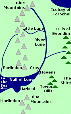 River
in Eriador. The River Lune began in the northeastern
Blue
Mountains and flowed southward for about 300 miles. The Lune had two
tributaries: a river from the Blue Mountains called the Little
Lune merged with the Lune from the west, and a river from the Hills
of Evendim joined the Lune from the east.
River
in Eriador. The River Lune began in the northeastern
Blue
Mountains and flowed southward for about 300 miles. The Lune had two
tributaries: a river from the Blue Mountains called the Little
Lune merged with the Lune from the west, and a river from the Hills
of Evendim joined the Lune from the east.
The River Lune flowed into the Gulf of Lune, which opened onto the Sea. The Grey Havens were located where the River Lune flowed into the Gulf.
The Gulf of Lune was created at the end of the First Age when Beleriand was destroyed and the Blue Mountains were divided. It was at that time that the River Lune changed its course to empty into the Gulf. The River Lune's original course is not known.
The Grey Havens were established at the mouth of the River Lune in the year 1 of the Second Age. Elves embarked from the Grey Havens to sail to the Undying Lands. Cirdan was Lord of the Havens and he lived there with many Elves.
More Elves dwelled in the surrounding region called Lindon, which lay mainly west of the Blue Mountains but also included the area east of the mountains to the River Lune and as far north as the Little Lune. North of the Little Lune was Dwarf country.
Sauron invaded Eriador in the middle of the Second Age and his forces were stopped at the Lune by Gil-galad, who defended the river to prevent the Grey Havens from being captured. In 1700, a fleet sent by Tar-Minastir of Numenor arrived in the Gulf of Lune and Sauron's forces were driven back.
When Elendil escaped the destruction of Numenor in 3319 of the Second Age, he sailed up the River Lune and settled with his followers in the lands east of the river. The Lune became the western boundary of Arnor, the North-kindgom of the Dunedain. There were a number of Dunedain settlements along the River Lune.
Arnor was divided into three kingdoms in 861 of the Third Age and the River Lune became the western boundary of Arthedain. In 1974, the Witch-king of Angmar invaded Arthedain and drove most of the Dunedain across the Lune into Lindon. But in 1975, help came from Gondor to the Gulf of Lune, and the Dunedain along with many Elves of Lindon recrossed the Lune into Arthedain. The Witch-king thought he could drive them back into the Lune, but his forces were defeated in the Battle of Fornost and he fled from the North.
Names &
Etymology:
Called the Lhûn in
Sindarin. Lune is a Common Speech adaptation of Lhûn.
The word lhûn means "blue" and is apparently an earlier version
of luin, the more commonly used word for "blue" as in Ered Luin,
the Blue Mountains, from which the Lhûn sprang.
Sources:
Appendix
A of The Lord of the Rings: "Eriador, Arnor and the Heirs of Isildur,"
p. 319; "The North-kingdom and the Dunedain," p. 320-21; "Gondor and the
Heirs of Anarion," p. 331; "Durin's Folk," p. 357
Appendix
B of The Lord of the Rings: "The Tale of Years," p. 363
Appendix
F of The Lord of the Rings: "The Languages and Peoples of the Third
Age," p. 412
The Silmarillion:
"Of
the Rings of Power and the Third Age," p. 285-86, 290
Unfinished
Tales: "The History of Galadriel and Celeborn," p. 239
The History
of Middle-earth, vol. V, The Lost Road and Other Writings: "The Etymologies,"
entry for LUG2
The History
of Middle-earth, vol. XII, The Peoples of Middle-earth: "Of Dwarves
and Men," p. 313, 328 notes 63 and 64
Mering Stream |
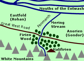 Stream
on the border between Rohan and Gondor.
The Mering Stream sprang from a deep cleft in the White
Mountains called the Firien-dale
and flowed through the Firien Wood. The
trees were especially dense on the banks of the Mering Stream.
Stream
on the border between Rohan and Gondor.
The Mering Stream sprang from a deep cleft in the White
Mountains called the Firien-dale
and flowed through the Firien Wood. The
trees were especially dense on the banks of the Mering Stream.
At the edge of the Firien Wood, the Great West Road passed over the Mering Stream by way of a bridge. The stream then continued northward through open lands to join the Mouths of the Entwash.
East of the Mering Stream was the province of Gondor called Anorien. West of the Mering Stream was marshland of the Fenmarch in the Eastfold of Rohan. Before the country of Rohan was established in 2510 of the Third Age, the land west of the Mering Stream was another province of Gondor called Calenardhon. As the population of Calenardhon declined, the people of Anorien fortified the Mering Stream to guard against an enemy invasion from the west.
Names &
Etymology:
The name Mering Stream means
"boundary stream" from the Old English maere or mere meaning
"boundary." The Sindarin name for the Mering Stream was Glanhír,
also meaning "boundary stream" from glan meaning "boundary, border"
and hir from sîr meaning "river, stream."
Sources:
Unfinished
Tales: "Cirion and Eorl," p. 300-302, 305-306, 318 note 46
"Nomenclature
of The Lord of the Rings," entry for Mering Stream
Morgulduin |
The
Morgulduin in the New Line film
|
 River
in the Morgul Vale; originally called
the
Ithilduin. The source of the Morgulduin was in the Mountains
of Shadow. The river flowed west out of the valley and through Ithilien
to the
Anduin.
River
in the Morgul Vale; originally called
the
Ithilduin. The source of the Morgulduin was in the Mountains
of Shadow. The river flowed west out of the valley and through Ithilien
to the
Anduin.
The Morgul-road ran alongside the Morgulduin on the northern bank. In the Morgul Vale the road crossed the Morgulduin over a white bridge. Hideous carved figures in human and bestial form stood at the head of the bridge. On the southern bank of the river was Minas Morgul, the stronghold of the Nazgul.
The waters of the Morgulduin were poisonous and deadly cold. Vapors rose from the river and gave off a terrible stench. Faramir warned Frodo Baggins and Sam Gamgee not to drink from the Morgulduin or any stream flowing from the Morgul Vale.
On March 10, 3019 of the Third Age, the two Hobbits saw the Witch-king lead a great army from Minas Morgul across the bridge spanning the Morgulduin and on down the road toward Minas Tirith. The bridge was cast down by the Host of the West on March 19.
The Morgul Vale remained uninhabitable for many years after the War of the Ring, but it is possible that over time the valley and the Morgulduin became cleansed of the taint of evil. It may be that the river was once again called the Ithilduin.
Names &
Etymology:
The name Morgulduin means "River
of Black Sorcery" in Sindarin. The word
morgul means "black sorcery."
The element
mor means "black, dark." The element gûl means
"sorcery, magic" from the stem
ngol or nólë meaning
"long study, lore, knowledge." The word duin means "river."
The original name Ithilduin means "River of the Moon." The word ithil means "moon."
Sources:
The Two
Towers: "Journey to the Cross-roads," p. 303, 306; "The Stairs of Cirith
Ungol," p. 312-16
The Return
of the King: "The Black Gate Opens," p. 161; "The Steward and the King,"
p. 247
The Silmarillion:
"Appendix - Elements in Quenya and Sindarin Names," entries for duin,
gul,
and mor
The History
of Middle-earth, vol. VIII, The War of the Ring: "Kirith Ungol," p.
181 (drawing of Minas Morghul and the Cross-roads); "The Second Map," p.
436
Narog |
Map
of the Narog
|
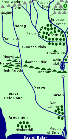 River
of Nargothrond in West Beleriand. The Narog
was a tributary of the Sirion. It was a swift-moving river that flowed
from north to south for about 240 miles. Its river valley was called the
Vale of Narog.
River
of Nargothrond in West Beleriand. The Narog
was a tributary of the Sirion. It was a swift-moving river that flowed
from north to south for about 240 miles. Its river valley was called the
Vale of Narog.
The source of the Narog was Eithel Ivrin at the foot of the Ered Wethrin. The Falls of Ivrin came down from the mountains and filled the Pools of Ivrin where the Narog originated.
A tributary called the Ginglith flowed into the Narog from the west. The Narog could be crossed at this point. The plain between the Ginglith and Narog was named Tumhalad. East of the Narog was Talath Dirnen, the Guarded Plain.
The Narog passed through a deep gorge at the western end of Andram, the Long Wall. The river formed rapids in the gorge but there was no waterfall. The Narog could not be crossed at this point until Turin had a bridge built over the gorge to the gates of Nargothrond.
In the steep west bank of the gorge were the Caverns of Narog which were expanded to become the stronghold of Nargothrond. The highlands of High Faroth surrounded Nargothrond west of the Narog. Another tributary called the Ringwil flowed into the Narog north of Nargothrond. Amon Ethir was on the east bank of the Narog about three miles from Nargothrond.
The Narog continued south and then curved eastward to join the Sirion. The woods of Nan-tathren were at the confluence of the two rivers. The Sirion emptied into the Bay of Balar which opened onto the Sea.
Ulmo, Lord of Waters, created Eithel Ivrin - the source of the Narog - in ancient times. In the year 20 of the First Age, many Elves gathered at Eithel Ivrin for the Feast of Reuniting convened by Fingolfin, the High King of the Noldor.
In 52, Finrod came to the Caverns of Narog - which had originally been inhabited by Petty Dwarves - and he began the construction of Nargothrond. The stronghold was completed in 102. Amon Ethir was built by Finrod as a guardpost. The Realm of Nargothrond extended east of the Narog to the Sirion and west of the Narog to the Nenning.
Turin drank from the Pools of Ivrin in 490 after he accidentally killed his friend Beleg, and he was healed of the madness that had overcome him. Turin went to Nargothrond and he convinced the Elves to build a bridge across the Narog to the gates of the stronghold to faciliate the passage of troops and armaments.
In 495, Morgoth sent an army led by Glaurung the Dragon against Nargothrond. Glaurung defiled the Pools of Ivrin and its waters were poisoned. The Elves fought Glaurung's army on the plain between the Narog and the Ginglith but they were defeated in the Battle of Tumhalad. Glaurung crossed the bridge over the Narog and captured Nargothrond.
Glaurung destroyed the Bridge of Nargothrond and the rubble fell into the river. In 496, Mablung led Morwen and Nienor to Nargothrond to seek Turin. Mablung crossed the ruined remains of the bridge to search the halls in vain for Turin.
Glaurung slithered across the Narog, and his fires caused a disorienting mist to rise from the waters. Morwen and Nienor became separated from their guards and each other in the fog. Glaurung cast a spell of forgetfulness on Nienor who later unknowingly married her brother Turin. Glaurung left Nargothrond in 499 and was slain by Turin, but both Turin and Nienor killed themselves when they learned that they were siblings.
Hurin - the father of Turin and Nienor - came to Nargothrond in 502 and crossed the Narog over the ruined bridge. Hurin found Mim the Petty-Dwarf living there and killed him because he had once betrayed Turin.
Beleriand was destroyed in the War of Wrath at the end of the First Age and the Narog no longer existed.
Names &
Etymology:
The name Narog is derived
from the root narak meaning "tear, rend" and naraka meaning
"rushing, rapid, violent" apparently in reference to the torrential rapids
of the river as it passed Nargothrond.
Sources:
The Silmarillion:
"Of the Sindar," p. 96; "Of the Return of the Noldor," p. 113-14; "Of Beleriand
and Its Realms," p. 120, 122; "Of Beren and Luthien," p. 168-70; "Of Turin
Turambar," p. 203, 209-15, 217-18; "Of the Ruin of Doriath," p. 230; "Of
Tuor and the Fall of Gondolin," p. 239
Unfinished
Tales: "Of Tuor and His Coming to Gondolin," p. 35, 37; "Narn I Hin
Hurin," p. 78, 99, 104, 116-20
The History
of Middle-earth, vol. V, The Lost Road and Other Writings: "The Etymologies,"
entries for NARAK
The History
of Middle-earth, vol. XI, The War of the Jewels: "The Grey Annals,"
p. 15, 34-35, 84-86, 88, 93, 139-40
The haven of Eglarest was at the mouth of the Nenning. The river emptied into a long narrow inlet that opened onto the Sea. On the northern side of the inlet was a cape where the watchtower of Barad Nimras stood. On the southern side of the inlet was a headland called Ras Mewrim or Bar-in-Myl, the Home of the Gulls.
Names &
Etymology:
The name Nenning contains
the Sindarin word nen meaning "water."
Sources:
The Silmarillion:
"Of Beleriand and Its Realms," p. 120; "Of the Fifth Battle," p. 196; "Of
Turin Turambar," p. 211; "Appendix - Elements in Quenya and Sindarin Names,"
entry for nen
The History
of Middle-earth, vol. XI, The War of the Jewels: "The Later Quenta
Silmarillion," p. 184, 190
The Nimrodel was named after an Elf maiden who once lived near the waterfall. After the Balrog awoke in Moria in 1980 of the Third Age, Nimrodel left Lothlorien and became lost in the southlands while her lover Amroth perished at sea trying to return to her. It is said that her voice could still be heard in the falls of the Nimrodel in springtime. The sound of the river was soothing and beautiful, "for ever blending its innumerable notes in an endless changeful music." (FotR, p. 360)
The Bridge of Nimrodel once spanned the river, but it was taken down, probably when Orcs began increasing in the area following the awakening of the Balrog. The river was shallow enough to wade across below the falls.
The Fellowship crossed the Nimrodel on January 15, 3019. Frodo felt his weariness washed away by the waters. Legolas sang the story of Nimrodel and Amroth. In a cluster of trees overhanging the Nimrodel near the falls, the Fellowship encountered three Elves of Lothlorien: Haldir, Rumil, and Orophin. The Fellowship spent the night in the Elves' flet in the trees.
During the night a company of Orcs from Moria crossed the Nimrodel seeking the Fellowship, but Haldir and his brothers led them deep into the woods and the Elves of Lothlorien made sure they never returned. Gollum also followed the Fellowship to the Nimrodel and started to climb the tree where Frodo was but was scared away by Haldir.
The next morning the Fellowship left the Nimrodel behind and were led to Caras Galadhon in Lothlorien.
Names &
Etymology:
The Nimrodel was named for
the Elf maiden whose name meant "Lady of the White Grotto," probably in
reference to her dwelling place near the waterfall. The element nim
means "white" and rod means "cave, grotto."
Sources:
The Fellowship
of the Ring: "Lothlorien," p. 353-61; "The Great River," p. 400
Unfinished
Tales: "The History of Galadriel and Celeborn - Amroth and Nimrodel,"
p. 240-48 and index entry (definition of Nimrodel)
The History
of Middle-earth, vol. V, The Lost Road and Other Writings: "The Etymologies,"
entries for NIK-W and ROD
Names &
Etymology:
The name Norbourn means "north
stream." A bourn is a small stream or brook.
Source:
The Lord
of the Rings: A Reader's Companion by Wayne G. Hammond and Christina
Scull: "Prologue," p. 24
Names &
Etymology:
The name Nunduinë means
"west river" in Quenya from nun meaning "west" and duinë
meaning "river."
Sources:
Unfinished
Tales: Map of Numenor; "A Description of the Island of Numenor," p.
168
Quenya-English
Wordlist
The Haradrim came over the Poros into Ithilien in 1944 of the Third Age. Earnil, the Captain of the Southern Army of Gondor, intentionally left the Crossings of Poros unguarded. He positioned his troops about 40 miles north of the river. When the Haradrim approached, the Southern Army destroyed them.
In 2885, the Haradrim occupied South Gondor. There were skirmishes along the Poros, and then a large army of Haradrim crossed the river into Ithilien. Turin II, Steward of Gondor, summoned help from Rohan. A great battle was fought at the Crossings of Poros. The Haradrim were defeated and were driven back over the river. Folcred and Fastred - the sons of King Folcwine of Rohan - were killed in the battle. They were buried in a mound called Haudh in Gwanur, the Tomb of the Twins, high on the northern bank of the Poros. The enemies of Gondor feared to pass their tomb.
Names &
Etymology:
The meaning of Poros is not
known. It may contain the element ros meaning "foam."
Sources:
Appendix
A of The Lord of the Rings: "Gondor and the Heirs of Anarion," p. 329;
"The Stewards," p. 335; "The House of Eorl," p. 350
Unfinished
Tales: "Cirion and Eorl," p. 291-92, 295
The Silmarillion:
"Appendix - Elements in Quenya and Sindarin Names," entry for ros
Men of Dale inhabited the lands between the River Running and the Redwater. During the War of the Ring, Easterlings crossed the Redwater and attacked Dale and the Lonely Mountain. The enemy forces were defeated and driven back over the river on March 27, 3019 of the Third Age.
Names and
Etymology:
A possible explanation for the name
Redwater
is that iron deposits from the Iron Hills may have turned sediment in the
riverbed a rusty red color.
The Redwater was called the Carnen in Sindarin which means "red water" from caran meaning "red" and nen meaning "water."
Sources:
Map of Wilderland
by Christopher Tolkien
Appendix
A of The Lord of the Rings: "Durin's Folk," p. 353
Appendix
B of The Lord of the Rings: "The Tale of Years," p. 375
The Silmarillion:
"Appendix - Elements in Quenya and Sindarin Names," entries for caran
and nen
The Ringlo was cold and swift as it came down from the mountains and passed through the Ringlo Vale. Near the mouth of the valley, the town of Ethring stood at the main crossing of the Ringlo. The road from Erech to Pelargir crossed the river at this point.
The Ringlo flowed southwestward through Lamedon and was joined by the River Ciril. The river continued its course and merged with the Blackroot, which then emptied into Cobas Haven on the Bay of Belfalas. At the confluence of the rivers was the Elf haven of Edhellond.
During the War of the Ring on March 10, 3019 of the Third Age, Aragorn and the Grey Company crossed the Ringlo en route from the Paths of the Dead to Pelargir.
Names &
Etymology:
The name Ringló means
"chill flood" from ring meaning "cold" and lô meaning
"soaking wet, swampy, flood." The latter element most likely referred to
the spreading floodwaters during the spring thaw in the snowfield at the
river's source.
Sources:
The Return
of the King: "Minas Tirith," p. 43; "The Last Debate," p. 151; and
detailed map of Gondor
Appendix
B of The Lord of the Rings: "The Tale of Years," p. 374
Unfinished
Tales: "The History of Galadriel and Celeborn," p. 247, 263; "Cirion
and Eorl," p. 316 note 39
"The Rivers
and Beacon-hills of Gondor," by J.R.R. Tolkien, edited by Carl F. Hostetter,
commentary by Christopher Tolkien, in Vinyar Tengwar #42, July 2001,
p. 10, 13-14
River Running |
The
River Running at the Front Gate by Alan Lee
|
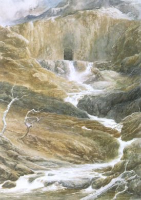 River
in Wilderland. The River Running was located
east of Mirkwood and it ran from the Lonely
Mountain south-southeast to the Sea of Rhun.
Its source was under the Lonely Mountain. The waters poured out of an opening
in the rock wall just inside the Front Gate. They flowed through a channel
carved by the Dwarves in ancient times and then flowed out of the Gate
over a cliff on the southern face of the mountain.
River
in Wilderland. The River Running was located
east of Mirkwood and it ran from the Lonely
Mountain south-southeast to the Sea of Rhun.
Its source was under the Lonely Mountain. The waters poured out of an opening
in the rock wall just inside the Front Gate. They flowed through a channel
carved by the Dwarves in ancient times and then flowed out of the Gate
over a cliff on the southern face of the mountain.
The River Running formed a wide loop in the valley south of the Lonely Mountain. There on the western bank was the town of Dale. The river then flowed south and widened to form Long Lake. There was a waterfall at the southern end of Long Lake, and from there the River Running continued its course southward and then curved southeast to flow into the Sea of Rhun.
The River Running had several tributaries. The Forest River, which began in the Grey Mountains and flowed southeast through Mirkwood, joined the River Running in Long Lake. A stream whose name is not known flowed east from the Mountains of Mirkwood into the River Running. The Redwater began in the Iron Hills in the north and flowed south to the River Running.
In the 1200s of the Third Age, the River Running was the eastern border of the lands ruled by the Northern leader Vidugavia, who called himself King of Rhovanion and whose realm extended west to Mirkwood. The Northmen also lived between the River Running and the Redwater, and while Thrain II was King Under the Mountain from 2590 to 2770 the Northmen prospered and were friendly with the Dwarves. The River Running was a major commerce route until the Smaug seized the Lonely Mountain from the Dwarves in 2770. Then Dale was destroyed and the survivors fled down the River Running to Lake-town.
When Thorin and company came to the Lonely Mountain in 2941, they travelled part of the way from Long Lake by boat on the River Running. Later Thorin showed Bilbo the source of the river at the Front Gate. The Battle of the Five Armies was fought in the valley where the River Running emerged from the Front Gate. Many Orcs were driven into the River Running by the victorious allies. After the battle, commerce arose again between the Dwarves of the Lonely Mountain and the Men of Dale and Lake-town and goods were transported up and down the River Running.
Names &
Etymology:
Also called the Running River.
The Sindarin name is Celduin. The name Celduin is formed
from the elements
cel or kel meaning "run (especially of
water)" and duin
meaning "river."
Sources:
The Hobbit:
"An Unexpected Party," p. 30; "A Short Rest," p. 62; "A Warm Welcome,"
p. 204; "On the Doorstep," p. 214-17 and illustration; "Not at Home," p.
254; "Fire and Water," p. 258, 261; "The Return Journey," p. 302; "The
Last Stage," p. 317
Appendix
A of The Lord of the Rings: "Gondor and the Heirs of Anarion," p. 326;
"Durin's Folk," p. 353
The Atlas
of Middle-earth by Karen Wynn Fonstad: "Map of Wilderland," p. 76-77;
"The Lonely Mountain" (text and map), p. 110-111
In 460 of the First Age, Beren found the Orcs who had slain his father Barahir camping near Rivil's Well. Beren killed the captain of the Orcs and retrieved the Ring of Barahir from him.
During the Battle of Unnumbered Tears in 472, the Men of Dor-lomin led by Hurin and Huor made their last stand at the Rivil. They defended the rearguard against Morgoth's forces to allow Turgon and the Elves of Gondolin to escape. The Men of Dor-lomin crossed to the southern bank of the Rivil and held their ground against the enemy and soon the stream was filled with the dead. Hurin was taken captive but Huor and the rest of the Men were all slain.
Names &
Etymology:
The meaning of the name Rivil
is unknown.
Sources:
The Silmarillion:
"Of Beren and Luthien," p. 163; "Of the Fifth Battle," p. 191, 194
Names &
Etymology:
The Sindarin name of the Rushdown
is Rhimdath, also spelled Rhibdath. The element rhim
or rhib means "flow like a torrent." The element dat means
"fall down."
Sources:
The History
of Middle-earth, vol. V, The Lost Road and Other Writings: "The Etymologies,"
entries for DAT, DANT and RIP; Index, p. 446
The History
of Middle-earth, vol. VI, The Return of the Shadow: "From Weathertop
to the Ford," p. 205
The Serni emptied into the Bay of Belfalas just west of the Mouths of the Anduin.* According to one source (UT, p. 463-64), the mouth of the Serni was blocked with pebbles and ships heading to the Anduin usually bypassed the Serni by going around the eastern side of Tolfalas. But during the War of the Ring, Men of Umbar and Harad apparently sailed up the Serni to Linhir and where they fought the Men of Lamedon.
Note:
There is some question about whether
it was the Gilrain or the Serni that flowed into the Bay of Belfalas after
they merged. Legolas described Linhir as being "above the mouth of the
Gilrain" (RotK, p. 151), which would
seem to indicate that the mouth of the Gilrain was on the Bay of Belfalas.
But the map and other sources such as Unfinished
Tales (p. 463-64) show that the Gilrain flowed into the Serni,
and the Serni in turn flowed into the Bay.
Names &
Etymology:
The name Serni is derived
from the Sindarin sarn meaning "pebble." Serni is an adjectival
form or a collective, like the Quenya sarnie meaning "shingle, pebble
bank."
Sources:
Map of Middle-earth
by Christopher Tolkien
The Return
of the King: "The Last Debate," p. 151
Unfinished
Tales: Index entry, p. 463-64
"The Rivers
and Beacon-hills of Gondor," by J.R.R. Tolkien, edited by Carl F. Hostetter,
commentary by Christopher Tolkien, in Vinyar Tengwar #42, July 2001,
p. 11
The Overbourn Marshes were located around the mouth of the Shirebourn. The Thistle Brook, which also sprang from the Green Hill Country, joined the Shirebourn near the village of Willowbottom.
Names &
Etymology:
A bourn is a small stream
or brook. The element shire is apparently not from the Shire but
instead from the Old English scir meaning "bright, clear." The river
Sherbourne in England was sometimes spelled Shirebourn.
Mithe is dervied from "mouth, river-mouth" in Old English.
Sources:
Atlas of
Middle-earth by Karen Wynn Fonstad, map of the Shire, p. 70-71
"The Adventures
of Tom Bombadil" in A Tolkien Reader: Preface, note 3; "Bombadil
Goes Boating," p. 206
Bombadil
in the Shire by Lalaith
The Lord
of the Rings: A Reader's Companion by Wayne G. Hammond and Christina
Scull: "The Maps of The Lord of the Rings," p. lix
The springs of the Silverlode were icy cold. The river was fed by a number of mountain streams before it merged with its major tributary, the Nimrodel. The Silverlode became a strong, swift, and deep river as it passed through Lothlorien. The Elves of Lothlorien crossed the Silverlode using ropes tied between trees on either bank.
The region of Lothlorien between the Silverlode and the Anduin was called the Naith. Cerin Amroth and Caras Galadhon were located there. Where the two rivers met, the land came to a point known as the Angle. At the very tip of the Angle was a green lawn called the Tongue. There was a small haven for boats called a hythe on the Silverlode side of the Tongue.
The woods of Lothlorien also extended south of the Silverlode. Between the southern edge of the woods and the River Limlight was a large open grassland called the Field of Celebrant.
On January 16, 3019 of the Third Age, Haldir led the Fellowship across the Silverlode using two ropes as a bridge. The Fellowship left Lothlorien a month later on February 16 using boats docked at the hythe which they rowed down the Silverlode to the Anduin. Gollum was hiding in the woods near the Silverlode and followed them.
Names &
Etymology:
The Silverlode probably got its
name from deposits of silver found in the riverbed by the Dwarves of Khazad-dum.
The Dwarves' name for the river was Kibil-nâla. The word kibil
apparently means "silver." The meaning of nala is not known, but
it may mean "rivercourse."
The Sindarin name of the Silverlode was the Celebrant. The word celeb means "silver" and the word rant means "lode, vein; flow, course of river."
Sources:
The Fellowship
of the Ring: "The Ring Goes South," p. 287, 296-97; "The Bridge of
Khazad-dum," p. 336; "Lothlorien," p. 348-49, 353-56, 360-64; "Farewell
to Lorien," p. 387--89, 393; "The Great River," p. 399, 404
The Return
of the King: "Many Partings," p. 263
Unfinished
Tales: "The History of Galadriel and Celeborn," p. 245, 260-61; "The
Disaster of the Gladden Fields," p. 281 note 14, 282 note 16; "The Hunt
for the Ring," p. 343
The Silmarillion:
"Appendix - Elements in Quenya and Sindarin Names" entry for celeb
The History
of Middle-earth, vol. V, The Lost Road and Other Writings: "The Etymologies"
entry for RAT
The History
of Middle-earth, vol. VII, The Treason of Isengard: "The Ring Goes
South," p. 174-75 note 22 (Kibil-nala & discovery of silver)
The Sirannon was a swift and noisy river with a bed of red and brown stones. A road ran along the northern bank of the Sirannon. The road connected the realms of the Elves of Eregion and the Dwarves of Khazad-dum. It seems likely that the Elvish city of Ost-in-Edhil was somewhere along the Sirannon at one end of the road. The other end of the road wound up the cliff of the Stair Falls to the West-gate of Khazad-dum.
After Khazad-dum was abandoned by the Dwarves and was populated by evil creatures, the Sirannon was dammed. It formed a great lake between the West-gate and the cliff of the Stair Falls. The rest of the river dried up so that it was nothing more than a trickle of water in a deep channel.
A creature called the Watcher in the Water lived in the lake. In 2994 of the Third Age, the Dwarves of Balin's expedition to Moria were prevented from escaping through the West-gate by the Watcher and the rising water.
On January 13, 3019, the Fellowship followed the dry riverbed of the Sirannon to the cliff of the Stair Falls. They circled the lake to the West-gate and were attacked by the Watcher as they entered Moria.
It is possible that the Sirannon was unblocked and allowed to return to its normal course after the War of the Ring.
Names &
Etymology:
The name Sirannon means "Gate-stream"
from sîr meaning "river" and annon meaning "great door
or gate." It was called the Gate-stream in the Common Speech.
Sources:
The Fellowship
of the Ring: "A Journey in the Dark," p. 313-23; "The Bridge of Khazad-dum,"
p. 336-37
The Silmarillion:
"Appendix - Elements in Quenya and Sindarin Names," entries for annon
and sir
The Siril's lower course was slow and winding. The river branched into a number of small streams as it flowed into the Sea between the promontories of Hyarnustar and Hyarrostar. There were marshes and reedbeds around the mouths of the Siril and the fishing village of Nindamos stood on the east side.
Names &
Etymology:
The name Siril means "rivulet"
in Quenya.
Sources:
Unfinished
Tales: "A Description of the Island of Numenor," p. 168
The History
of Middle-earth, vol. V, The Lost Road and Other Writings: "The Etymologies,"
entry for SIR
Note:
On one map of Gondor included with
an early edition of
Unfinished Tales
the Celos is mistakenly shown as flowing into the Sirith from the east
rather than the west.
Names &
Etymology:
The name Sirith means "a
flowing" from sîr meaning "river."
Sources:
Maps of Middle-earth
and Gondor by Christopher Tolkien
The Silmarillion:
"Appendix - Elements in Quenya and Sindarin Names," entry for sir
The History
of Middle-earth, vol. VII, The Treason of Isengard: "The First Map,"
p. 322 note 9 (map error)
At least one stream joined the Snowbourn from the western side of Harrowdale. There was a ford across the Snowbourn in front of the gates of Edoras, and there was another ford in Harrowdale near the stronghold of Dunharrow. Many willow trees grew on the banks of the Snowbourn, particularly at the point where it met the Entwash.
Names &
Etymology:
The Snowbourn was so called
because it sprang from the snows of the White Mountains. A bourn
is a small stream or brook.
Sources:
The Two
Towers: "The King of the Golden Hall," p. 110-11
The Return
of the King: "The Muster of Rohan," p. 64, 66, 68, 71, 76, 78
The Lord
of the Rings: A Reader's Companion by Wayne G. Hammond and Christina
Scull: "The Muster of Rohan," p. 538
On September 25, 3018 of the Third Age, after parting company with Gildor and the Elves, Frodo decided to take a shortcut to the Brandywine through the Woody End. The Hobbits became entangled and disoriented in the thickets and undergrowth until Pippin realized that the stream they were following was the Stockbrook. He determined that they should cross it and bear right to get back on course.
Names &
Etymology:
Also written as Stock-brook.
Sources:
The Fellowship
of the Ring: "A Short Cut to Mushrooms," p. 98-99
Atlas of
Middle-earth by Karen Wynn Fonstad, map of the Shire, p. 70-71
The Journeys
of Frodo by Barbara Strachey: Maps #1 "Hobbiton to Brandywine Bridge"
and #4 "Woody End"
Source:
Atlas of
Middle-earth by Karen Wynn Fonstad, map of the Shire, p. 70-71
The Water could be crossed in several places. Budge Ford was located near Whitfurrows on the road leading north to Scary. There was a narrow plank-bridge west of Hobbiton and a main bridge in Hobbiton itself. Sandyman's Mill stood on the north bank of the Water by the bridge in Hobbiton.
Frodo Baggins and his companions crossed the Water by way of the narrow plank-bridge west of Hobbiton on the evening of September 23, 3018 of the Third Age. As they climbed into the Green Hill Country, Frodo turned and looked back into the valley of the Water and wondered if he'd ever do so again.
During the War of the Ring, the old Mill was replaced with a large brick stucture that straddled the stream. The Water was polluted from Hobbiton all the way down to the Brandywine. The New Mill was torn down after the Battle of Bywater and the Water ran clear once more.
Names &
Etymology:
The Water was a shortening
of the river's full name, the Shire-water.
Sources:
The Fellowship
of the Ring: Map of "A Part of the Shire"; "Three Is Company," p. 80
The Return
of the King: "The Scouring of the Shire," 293, 296
Atlas of
Middle-earth by Karen Wynn Fonstad, map of the Shire, p. 70-71
The Journeys
of Frodo by Barbara Strachey: Map #2 "Hobbiton to Bywater"
The Lord
of the Rings: A Reader's Companion by Wayne G. Hammond and Christina
Scull: "A Long-Expected Party," p. 66; "A Conspiracy Unmasked," p. 119
Withywindle |
Old
Man Willow on the Withywindle by J.R.R. Tolkien
|
 River
in the Old Forest in Eriador.
The Withywindle valley was said to be the heart of all the strange happenings
in the Old Forest. The Withywindle began in the Barrow-downs
and flowed southwest through the Old Forest to join the Brandywine.
At the mouth of the Withywindle there was a hythe - or haven - in the north
bank called the Grindwall. The Grindwall was beyond the protection of the
High
Hay, so it was guarded and there was a fence extending into the water.
River
in the Old Forest in Eriador.
The Withywindle valley was said to be the heart of all the strange happenings
in the Old Forest. The Withywindle began in the Barrow-downs
and flowed southwest through the Old Forest to join the Brandywine.
At the mouth of the Withywindle there was a hythe - or haven - in the north
bank called the Grindwall. The Grindwall was beyond the protection of the
High
Hay, so it was guarded and there was a fence extending into the water.
There was a small village named Breredon behind the Grindwall between the end of the High Hay and the Brandywine. The village of Haysend was also located at the mouth of the Withywindle. The Elvet-isle in the Withywindle was home to swans.
When Frodo Bagginsand his companions entered the Old Forest on September 26, 3018 of the Third Age, they found themselves drawn toward the Withywindle valley despite their intentions, and on the banks of the river they encountered Old Man Willow, an ancient tree whose hatred of all peoples who walked free on the earth permeated the woods. The Hobbits were lulled to sleep by Old Man Willow's spell. Frodo was pushed into the Withywindle and was held under by the willow's roots until Sam saved him, and Merry and Pippin were trapped inside Old Man Willow. They were rescued by Tom Bombadil.
Long ago, Tom had found Goldberry, the River-daughter, in a pool down the Withywindle, and at the end of every summer he would go along the river to gather water-lilies for her. He was on his last trip of the year when he encountered the Hobbits.
Names &
Etymology:
The word withy means "willow"
and windle means "spindle" or "reel." Withywind is a type
of bindweed, or convolvulus, a harmful weed that twines itself around other
plants. The word withywind means "flexibly strong, entangle."
The word grind in Grindwall means "fence."
Sources:
The Fellowship
of the Ring: "A Conspiracy Unmasked," p. 109; "The Old Forest," p.
124-133; "In the House of Tom Bombadil," p. 137
"Nomenclature
of The Lord of the Rings," entry for Withywindle
"The Adventures
of Tom Bombadil" in A Tolkien Reader: Preface, note 3; "Bombadil
Goes Boating," p. 205
Bombadil
in the Shire by Lalaith
withwind at Wiktionary
Dimrost |
Map
showing Dimrost
|
 Waterfall
on the Celebros in the Forest of Brethil.
Dimrost, the Rainy Stair, was located just below the wooden bridge where
the road from the Crossings of Teiglin to Ephel
Brandir crossed the Celebros. A heavy mist rose from the waterfall
as it cascaded over a series of stone steps into a rocky basin.
Waterfall
on the Celebros in the Forest of Brethil.
Dimrost, the Rainy Stair, was located just below the wooden bridge where
the road from the Crossings of Teiglin to Ephel
Brandir crossed the Celebros. A heavy mist rose from the waterfall
as it cascaded over a series of stone steps into a rocky basin.
At the top of the falls, there was a wide green lawn ringed with birches. From the bridge, there was a view to the Ravines of Teiglin two miles away to the southwest. The air was cool there and it was a favorite resting place for travelers. Beyond the falls, the Celebros continued on to join the Teiglin.
In 496 of the First Age, Glaurung cast a spell on Nienor that caused her to lose her memory. She fled to the Forest of Brethil, where she was found by her brother Turin. Turin had never met his sister and did not know who she was, and he called her Niniel.
Turin took Niniel to Ephel Brandir, but as she crossed the bridge she began to shiver uncontrollably. Afterwards, Dimrost became known as Nen Girith, the Shuddering Water.
Niniel married Turin in 498, and she soon became pregnant. In 499, Glaurung attacked the Forest of Brethil. Turin set out to slay the Dragon, and at sunset he stopped at the bridge over Dimrost to see the lay of the land and meet with his scouts. He learned that Glaurung had reached the Ravines of Teiglin but had not yet crossed, so Turin continued on to ambush the Dragon.
Niniel convinced many of the people of Brethil to follow Turin and they got as far as Dimrost. Niniel was again overcome by shuddering. Then they heard Glaurung's screams as Turin stabbed him and they saw fire in the woods near the Ravines of Teiglin. Not knowing what had happened, they were afraid to go on. Brandir tried to lead Niniel to safety but she ran to the Ravines of Teiglin to find Turin.
Niniel found Turin unconscious and apparently dead. With his dying words, Glaurung told Niniel that she was Turin's sister. Niniel threw herself into the ravine called the Deer's Leap, afterwards known as the Leap of Dreadful Doom.
Brandir told the people waiting at Dimrost that Niniel and Turin were dead, but then Turin arrived at daybreak. When Brandir told Turin the truth about Niniel and her fate, Turin slew Brandir and then ran back to where Glaurung's body lay and killed himself.
Names &
Etymology:
The name Dimrost is translated
as "Rainy Stair." The word ros means "foam, spray, rain." The first
element, apparently meaning "stair," is of uncertain origin.
The falls were renamed Nen Girith, the Shuddering Water, after Niniel shuddered in premonition of the terrible events that would occur at the Ravines of Teiglin within sight of the bridge over the falls. The word nen means "water" and girith means "shuddering" in Sindarin.
Also called the Falls of Celebros.
Sources:
The Silmarillion:
"Of Turin Turambar," p. 220-22, 224; "Elements in Quenya and Sindarin Names,"
entries for nen, girith, ros
Unfinished
Tales: "Narn I Hin Hurin," p. 123, 128-30, 132, 135-36, 139-43, 145,
149 note 24 and map
The History
of Middle-earth, vol. IV, The Shaping of Middle-earth: "The Quenta,"
p. 186-87
The History
of Middle-earth, vol. XI, The War of the Jewels: "The Grey Annals,"
p. 96-101, 151, 156-59, 163; "The Wanderings of Hurin," p. 295-96, 306
note 52 and 53, 308 note 55
The Children
of Hurin: "Nienor in Brethil," p. 216; "The Coming of Glaurung," p.
225, 228-30, 232-33; "The Death of Glaurung," p. 239-40, 246-47; "The Death
of Turin," p. 249-53, 256; "Appendix," p. 289-91 and map
See Eithel Ivrin.
Falls of Rauros |
The
Falls of Rauros
in the New Line film |
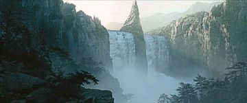 Great
waterfall on the River Anduin. The Falls of Rauros
were located at the southern end of Nen Hithoel,
a lake formed by the Anduin among the hills of the Emyn
Muil. The Falls cascaded over a high cliff into a basin called Rauros-foot.
There was a great roaring noise and a misty spray around the Falls. Below
the Falls lay the marshland of the Wetwang
around the Mouths of the Entwash. The North
Stair was carved into the cliff along the western side of the Falls
of Rauros, providing a portage-way for boats to bypass the waterfall.
Great
waterfall on the River Anduin. The Falls of Rauros
were located at the southern end of Nen Hithoel,
a lake formed by the Anduin among the hills of the Emyn
Muil. The Falls cascaded over a high cliff into a basin called Rauros-foot.
There was a great roaring noise and a misty spray around the Falls. Below
the Falls lay the marshland of the Wetwang
around the Mouths of the Entwash. The North
Stair was carved into the cliff along the western side of the Falls
of Rauros, providing a portage-way for boats to bypass the waterfall.
After the death of Boromir on February 26, 3019 of the Third Age, his body was placed in an Elven-boat of Lothlorien and was borne over the Falls of Rauros and downriver to the Sea.
Names &
Etymology:
Also called Rauros Falls.
The name Rauros means "roaring foam" from rau meaning "lion"
and ros meaning "foam, spray."
Sources:
The Fellowship
of the Ring: "Farewell to Lorien," p. 384, 389-90; "The Great River,"
396, 406, 410; "The Breaking of the Fellowship," p. 413, 416, 418, 423
The Two
Towers: "The Departure of Boromir," p. 15, 17-20; "The Riders of Rohan,"
p. 38; "Of Herbs and Stewed Rabbit," p. 266; "The Window on the West,"
p. 271-72, 275, 286
The Return
of the King: "Minas Tirith," p. 31; "The Last Debate," p. 155; "The
Field of Cormallen," p. 233; "The Steward and the King," p. 249
The History
of Middle-earth, vol. V, The Lost Road and Other Writings: "The Etymologies,"
entries for RAW and ROS1
The Lord
of the Rings: A Reader's Companion by Wayne G. Hammond and Christina
Scull: "The Great River," p. 346 (Rauros-foot basin)
The Stair Falls were once strong and full. But the waterfall was cut off when the Sirannon was dammed, forming a pool where the Watcher in the Water lurked.
The Fellowship came to the cliff where the Stair Falls had been on January 13, 3019 of the Third Age. Gandalf, Gimli, and Frodo climbed the Stair and discovered that the pool blocked their path. They returned down the Stair and used the main path up the cliff and around the pool.
It seems possible that after the War of the Ring, the Sirannon may have been unblocked and the Stair Falls may have flowed once more, but this is nowhere stated.
Sources:
The Fellowship
of the Ring: "A Journey in the Dark," p. 314-16; "The Bridge of Khazad-dum,"
p. 336-37
All entries are Copyright © by the Thain from former tuckborough.net. Please contact me if you are Thain or know anything about how to contact the original author.
2003-2011, The Thain's Book - thainsbook.minastirith.cz
- e-mail: thain at tuckborough.net