
An encyclopedia of Middle-earth and Numenor
|
|
|
|
|
|
|
|
|
|
|
|
|
|
| |
|
|
An encyclopedia of Middle-earth and Numenor |
|

|
|
|
|
|
|
|
|
|
|
|
|
|
Brithombar & Eglarest |
Map
of Brithombar and Eglarest
|
 Havens
of the Falas. Brithombar and Eglarest were located on the west coast of
Beleriand in the region called the Falas. Brithombar was to the north and
stood at the mouth of the River Brithon.
Eglarest was to the south at the head of the firth at the mouth of the
River
Nenning.
Havens
of the Falas. Brithombar and Eglarest were located on the west coast of
Beleriand in the region called the Falas. Brithombar was to the north and
stood at the mouth of the River Brithon.
Eglarest was to the south at the head of the firth at the mouth of the
River
Nenning.
Between the two havens was a cape where the tower of Barad Nimras stood. North of Brithombar was Cape Andras, and south of Eglarest was a headland called Ras Mewrim or Bar-in-Myl, the Home of the Gulls. A road led north along the coast from Brithombar to Vinyamar in Nevrast.
Brithombar and Eglarest were established by the Elves of the Falas sometime around 1149 of the Years of the Trees. The Elves of the Falas were Teleri who had been persuaded to forsake the journey to the Undying Lands by Osse - a Maia whose domain was the seas and coasts of Middle-earth. They became mariners and Cirdan the Shipwright was their lord.
In 1497, Morgoth sent Orcs to invade Beleriand. In the First Battle, Cirdan's forces were cut off from the army of King Thingol of Doriath and were driven back to the coast. The Elves of the Falas were besieged in their Havens until later that year when the Noldor arrived in Middle-earth to retrieve the Silmarils from Morgoth. The siege army withdrew from the Havens and the Noldor defeated them in the Battle-under-Stars.
In 52 of the First Age, Finrod Felagund established the realm of Nargothrond which extended west as far as the River Nenning bordering the Falas. Finrod became a friend and ally of Cirdan and the Elves of the Falas.
In 65, the Noldor of Nargothrond used their skills to build new walls around Brithombar and Eglarest as well as towns within the walls and harbors with stone piers and quays. Barad Nimras was built at this time to keep watch for enemy ships, but Morgoth never waged war from the Sea.
In 456 after the Battle of Sudden Flame, Fingon, the High King of the Noldor, sent his young son Gil-galad to live with Cirdan at the Havens of the Falas. In 462, Cirdan sailed a fleet from the Havens to the Firth of Drengist to help Fingon drive back an army that had invaded Hithlum.
Cirdan and the Elves of the Falas fought in the Battle of Unnumbered Tears in 472, which resulted in a victory for Morgoth. Afterwards, refugees from other parts of Beleriand came to the Havens of the Falas. Cirdan sent ships along the coasts to harrass the enemy.
In 473, Morgoth sent an army to attack Brithombar and Eglarest. They ravaged the Falas as they came down the Brithon and the Nenning to the walled Havens. Smiths and miners used engines and fire to tear down the walls, and despite the valiant defense of the Elves of the Falas the Havens were overrun. Brithombar and Eglarest and Barad Nimras were all destroyed.
Many of the Elves of the Falas were killed or enslaved, but some escaped. Cirdan and Gil-galad led a group of survivors to settle on the Isle of Balar south of the Falas. According to one story (UT, p. 247), three ships from Brithombar and Eglarest may have sailed even farther south to the Bay of Belfalas to establish the haven of Edhellond.
In an early account of the War of Wrath (HoME V, p. 144), the Host of the Valar from the Undying Lands came ashore at Eglarest and drove back the Orcs from the coast. Morgoth's forces were defeated in the war, but most of Beleriand was destroyed including Brithombar and Eglarest.
Names &
Etymology:
The name Brithombar means
"dwelling on the Brithon" in Sindarin. The river name Brithon means
"pebbly" from brith meaning "gravel." The ending mbar means
"dwelling."
The name Eglarest means "ravine of the Eglain" in Sindarin. The name Eglain means "the Forsaken" and was used by the Elves who remained in Middle-earth while other Elves went to the Undying Lands. The word rest means "ravine."
Also called together the Havens of the Falas - where Falas means "coast, shore" - and the Havens of the Shipwrights.
Sources:
The Silmarillion:
"Of Eldamar," p. 58; "Of the Sindar," p. 96-97; "Of the Return of the Noldor,"
p. 107-8, 113; "Of Beleriand and Its Realms," p. 120-22; "Of the Ruin of
Beleriand," p. 154, 160; "Of the Fifth Battle," p. 190, 196; "Of the Voyage
of Earendil," p. 246
Unfinished
Tales: "Of Tuor and His Coming to Gondolin," p. 33-34; 51 note 1, 53
note 13, 54 note 22; "The History of Galadriel and Celeborn," p. 247
The History
of Middle-earth, vol. V, The Lost Road and Other Writings: "The Later
Annals of Beleriand," p. 144, 153; "The Etymologies," entries for BIRIT,
MBAR, PHAL, and RIS
The History
of Middle-earth, vol. X, Morgoth's Ring: "The Annals of Aman," p. 85
The History
of Middle-earth, vol. XI, The War of the Jewels: "The Grey Annals,"
p. 5, 8, 15-18, 34, 39-40, 56, 77, 80, 89, 117; "The Later Quenta Silmarillion,"
p. 184 (map), 189 notes 56 and 57, 190 note 63, 197; "Quendi and Eldar,"
p. 365, 379-80, 418 note 8
In the late 400s of the First Age, the diminished population of the People of Haleth lived in Ephel Brandir in secrecy according to the policy of their leader Brandir, who hoped to avoid conflict with Morgoth's forces.
In 496, Turin came to live in Ephel Brandir with the Men of Brethil. Later that year, Turin found a distraught woman in the forest and brought her back to Ephel Brandir to be healed. The woman had amnesia and Turin did not realize that she was his sister Nienor. He called her Niniel and they were married in 498.
In 499, Glaurung came to the edge of the Forest of Brethil. To prevent the Dragon from attacking Ephel Brandir, Turin went forth to confront him at the River Teiglin. He advised the others to remain in the stockade but to scatter if Glaurung approached. Turin slew Glaurung, but before he died the Dragon told Niniel that she was Turin's sister and she killed herself. Brandir reported what Glaurung had said to Turin and Turin killed Brandir thinking he was lying. When Turin learned the truth he committed suicide as well.
According to a later story called "The Wanderings of Hurin" (HoME XI, 251-310), the settlement on Amon Obel was named Obel Halad. The main feature of Obel Halad was the Hall of the Chieftains which was in a garth enclosed by an earthwall with a single gate. At the back of Amon Obel was a meeting place called the Moot-ring which was carved into the side of the hill with seven tiers of seats enclosed by a stockade. It is not clear whether Tolkien intended to simply rename Ephel Brandir as Obel Halad or whether his entire concept of the settlement changed.
In this story, Hurin - the father of Turin and Nienor - came to the Forest of Brethil around 501. He was brought to Obel Halad and was imprisoned after a dispute with Brandir's successor Hardang. This caused dissension amongst the Men of Brethil. During the fighting, Hardang was killed and the Hall of the Chieftains was burned down and most of Obel Halad was ruined.
Names &
Etymology:
The name Ephel Brandir means
"encircling fence of Brandir" in Sindarin. Also called the Ephel.
The alternate name Obel Halad may mean "town of the chieftain" in
the language of the People of Haleth. The word halad means "chief."
The word obel may mean "town, enclosed dwelling-place."
Sources:
The Silmarillion:
"Of Turin Turambar," p. 216, 219-21; Index, entry for Ephel Brandir
Unfinished
Tales: "Narn I Hin Hurin," p. 110-11, 122-23, 126-28, 131-32, 136,
141
The Children
of Hurin: "The Coming of Turin into Brethil," p. 193, 195; "Nienor
in Brethil," p. 216, 220; "The Coming of Glaurung," p. 222, 225-26, 232-33;
"The Death of Glaurung," p. 239
The History
of Middle-earth, vol. XI, The War of the Jewels: "The Grey Annals,"
p. 89, 92, 96-97, 148; "The Wanderings of Hurin," p. 258, 263-67, 271,
276, 292, 296-97, 301 note 17, 306 note 53, 308 note 54
Appendix
E of The Lord of the Rings: "Writing and Spelling," p. 392 (definition
of ephel)
Names &
Etymology:
Archet is an English place-name
of Celtic origin. The word chet means wood, and the name seems intentionally
related to Chetwood.
Sources:
The Fellowship
of the Ring: "At the Sign of the Prancing Pony," p. 161; "A Knife in
the Dark," p. 193-94
The Return
of the King: "Homeward Bound," p. 271
The Journeys
of Frodo by Barbara Strachey: Map #10 "Bree"
"Nomenclature
of The Lord of the Rings," entry for Archet
Bree |
Bree
street from the New Line film
|
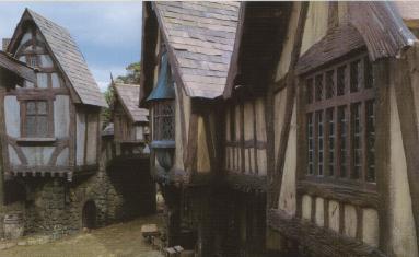 Village
at the crossroads of the Great East
Road and the Greenway in Eriador.
Bree was unique in that the Big Folk (Men) and Little Folk (Hobbits) both
dwelled there on friendly terms. Bree was also a meeting place for travelers,
particularly at the famous local inn called the Prancing
Pony. The art of smoking pipe-weed
was said to have begun in Bree.
Village
at the crossroads of the Great East
Road and the Greenway in Eriador.
Bree was unique in that the Big Folk (Men) and Little Folk (Hobbits) both
dwelled there on friendly terms. Bree was also a meeting place for travelers,
particularly at the famous local inn called the Prancing
Pony. The art of smoking pipe-weed
was said to have begun in Bree.
Bree was an ancient settlement. The Men of Bree claimed to be the descendants of the first Men to inhabit western Middle-earth. It is not known exactly when Bree was founded, but their legends said that "when the Kings returned again over the Great Sea they had found the Bree-men still there." (FotR, p. 161) This may refer to the first voyages of the Numenoreans to Middle-earth and their meeting with the Men of Eriador around the year 600 of the Second Age.
Numenor was destroyed in 3319 of the Second Age and the survivors led by Elendil came to Middle-earth and founded the kingdoms of Gondor and Arnor in 3320. At that time, Bree became part of the North-kingdom of Arnor.
The village of Bree became a thriving community as travelers passed through on the main roads. The first Hobbits came to Bree around 1300 of the Third Age. It was from Bree in the year 1601 that Marcho and Blanco led a group of Hobbits west to found the Shire.
Bree was located in Bree-land, a small area that also included the villages of Archet, Combe, and Staddle. Bree was on the western side of Bree-hill near the southwestern corner of the Chetwood. There were about 100 stone houses by the hillside where Men lived; Hobbits tended to live farther up the slopes.
A deep dike and a hedge formed a semi-circular fence enclosing the village against the hill. There were gates on the western and southern sides of the hedge. The gates were closed and guarded at night, though the traffic on the roads had lessened over the years.
The gathering place for Bree-landers and travelers alike was the Prancing Pony, an inn run by Barliman Butterbur. The inn was known as a place where one could hear news from the outside world. "Strange as News from Bree" was an old saying in the Shire.
One important chance meeting in Bree took place on March 15, 2941. There Thorin Oakenshield, who wanted to reclaim the Lonely Mountain from Smaug the Dragon, met Gandalf, who was worried that Sauron might use Smaug to regain the northern realm of Angmar. The two travelers concocted a plan to set out for the Lonely Mountain with thirteen Dwarves and one Hobbit named Bilbo Baggins.
Seventy-seven years later, on September 29, 3018, Frodo Baggins arrived in Bree and there encountered the Ranger known as Strider, whose true name was Aragorn. Aragorn became the Hobbits' guide and protector. After the Prancing Pony was attacked in the night, he led the Hobbits away from Bree and into the Wild, hoping to evade the Nazgul who pursued the Ring-bearer.
By the autumn of 3018, Men from the South had started arriving in Bree looking for a new place to live. They were mainly ruffians and thieves, and soon the regular Bree-folk were afraid to leave their homes. Early in the New Year of 3019 there was a fight in which five Bree-folk were killed - three Men and two Hobbits. After that the ruffians were expelled from Bree, but they still roamed the woods and the roads. There were also wolves and other nameless things abroad. The Rangers who had long protected Bree and the Shire had gone south to join Aragorn.
On October 28, 3019, Gandalf and the four Hobbits stopped in Bree and told Barliman Butterbur that the Rangers had returned and that there was a King again and that soon Bree and Bree-land would be safe once more.
Names &
Etymology:
Bree is from the Celtic word
for "hill."
Sources:
The Fellowship
of the Ring: "At the Sign of the Prancing Pony," p. 161-64 and passim
The Return
of the King: "Homeward Bound," passim
Appendix
A of The Lord of the Rings: "Durin's Folk," p. 358-59
The Journeys
of Frodo by Barbara Strachey: Map #10 "Bree"
"Nomenclature
of The Lord of the Rings," entry for Archet
Names &
Etymology:
Combe is from the word coomb
which means "deep valley."
Sources:
The Fellowship
of the Ring: "At the Sign of the Prancing Pony," p. 161; "A Knife in
the Dark," p. 192, 193
"Nomenclature
of The Lord of the Rings," entry for Coomb
Names &
Etymology:
Staddle is from the Old Englishstaðol
meaning
"foundation" of buildings, etc.
Sources:
The Fellowship
of the Ring: "At the Sign of the Prancing Pony," p. 161; "A Knife in
the Dark," p. 192-93
The Return
of the King: "Homeward Bound," p. 271
"Nomenclature
of The Lord of the Rings," entry for Staddle
Annúminas |
Map
of Annuminas & Fornost
|
 Capital
of the North-kingdom of Arnor. Annuminas was located
in Eriador. The city was on the southeastern
shore of Lake Evendim among the Hills
of Evendim north of the Shire. The Brandywine
River flowed from Lake Evendim just north of Annuminas.
Capital
of the North-kingdom of Arnor. Annuminas was located
in Eriador. The city was on the southeastern
shore of Lake Evendim among the Hills
of Evendim north of the Shire. The Brandywine
River flowed from Lake Evendim just north of Annuminas.
Annuminas was the seat of Elendil, the High King of Gondor and Arnor, who dwelled in the north while his sons Isildur and Anarion jointly ruled Gondor in the south. The chief token of royalty of the North-kingdom of Arnor was the Sceptre of Annuminas. The palantir called the Stone of Annuminas was kept in the city and was used by the King.
After the death of Elendil in the War of the Last Alliance in 3441 of the Second Age, the rule of the North-kingdom of Arnor passed to the heirs of Elendil's son Isildur. Valandil, the youngest son of Isildur, became King of Arnor in the year 10 of the Third Age and he moved to Annuminas from Rivendell, where he had lived as a child.
In 861, the North-kingdom was divided into three kingdoms: Arthedain, Cardolan, and Rhudaur. Amlaith, the first King of Arthedain, made Fornost his capital city, and Annuminas fell into ruin and was deserted for over 2,000 years.
When Aragorn, King Elessar, became King of the Reunited Kingdom of Gondor and Arnor in 3019, he rebuilt Annuminas as his northern capital. In the year 15 of the Fourth Age, Aragorn and Queen Arwen went north to dwell in Annuminas for a while. Thain Peregrin Took and Mayor Samwise Gamgee visited the King and Queen in Annuminas many times.
Names &
Etymology:
Annúminas means "Tower
of the West" from the Sindarin annûn meaning "sunset, west"
and minas meaning "tower."
Sources:
The Fellowship
of the Ring: "The Council of Elrond," p. 257
The Two
Towers: "The Palantir," p. 203
The Return
of the King: "The Steward and the King," p. 251
Appendix
A of The Lord of the Rings: "The Numenorean Kings," p. 317; "The North-kingdom
and the Dunedain," p. 323 and note 1, p. 324
The Silmarillion:
"Of
the Rings of Power and the Third Age," p. 290, 292, 296; "Appendix - Elements
in Quenya and Sindarin Names," entries for andune and minas;
Index entry for Annuminas (definition)
Unfinished
Tales: "The Palantiri," p. 410-11, 413
The History
of Middle-earth, vol. XII, The Peoples of Middle-earth: "The Heirs
of Elendil," p. 193; "The Tale of Years of the Third Age," p. 228
Annuminas was the original capital of Arnor until 861 of the Third Age, when the North-kingdom was divided into Arthedain, Cardolan, and Rhudaur. The line of Kings was maintained in Arthedain, and the first King of Arthedain moved his capital from Annuminas to Fornost. He was known as Amlaith of Fornost. Amlaith brought the palantir called the Stone of Annuminas to his new capital. Fornost remained the seat of the North-kingdom for over 1,000 years.
In 1409, the Witch-king of Angmar attacked the North-kingdom. The Stone of Amon Sul was brought to Fornost for safekeeping after the Witch-king destroyed the Tower of Amon Sul. The Witch-king's forces attacked Fornost, but they were driven back by the young King Araphor with the help of Cirdan the Shipwright.
Fornost was captured by the Witch-king in 1974. King Arvedui of Arthedain and his people were driven out of Fornost and the Witch-king came to live there along with many of his evil folk. In 1975, a host of Elves and Men challenged the Witch-king, and he rode forth from Fornost onto the plain west of the city to meet them. The Witch-king's forces were defeated in the Battle of Fornost and the Witch-king fled from the north.
After the battle, the Dunedain were scattered and though they went to Fornost from time to time, the city was not reclaimed. Fornost stood deserted, but its evil reputation remained and it became known as Deadman's Dike. The city fell into ruin and was overgrown with grass. It was not until the Fourth Age after Aragorn, King Elessar, reunited the Kingdoms of Gondor and Arnor that people came to dwell in Fornost once more.
Names &
Etymology:
Fornost means "northern fortress"
in Sindarin from forn meaning "north" and ost meaning "fortress."
It was also called Fornost Erain - "northern fortress of the Kings."
Erain
is
the plural of aran meaning "king."
Fornost was called Norbury in the Common Speech, which also means "northern fortress," from the Old English norð burg. It was also called Norbury of the Kings or Kings' Norbury.
While the city was deserted it was known as Deadman's Dike.
Sources:
The Fellowship
of the Ring: "Prologue - Concerning Hobbits," p. 13-14, 18; "The Council
of Elrond," p. 257
The Return
of the King: "Homeward Bound," p. 273
Appendix
A of The Lord of the Rings: "The North-kingdom and the Dunedain," p.
320-21; "Gondor and the Heirs of Anarion," p. 331
The History
of Middle-earth, vol. XII, The Peoples of Middle-earth: "The Tale of
Years of the Third Age," p. 228
The Silmarillion:
"Appendix - Elements in Quenya and Sindarin Names," entries for formen
and os(t)
"Nomenclature
of The Lord of the Rings," entry for Norbury
Grey Havens |
Top:
Map of the Grey Havens
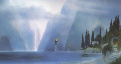
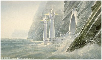
Bottom: The Grey Havens by John Howe |
 Port
on the northwestern coast of Middle-earth. The Grey Havens were the place
from which the ships of the Elves sailed westward across the Sea to the
Undying Lands, where the spirits called the Valar dwelled. At the end of
the Third Age, many Elves left Middle-earth from the Grey Havens, and the
Ringbearers
Frodo and
Bilbo
Baggins also embarked from there so they could find peace and healing
in the Undying Lands.
Port
on the northwestern coast of Middle-earth. The Grey Havens were the place
from which the ships of the Elves sailed westward across the Sea to the
Undying Lands, where the spirits called the Valar dwelled. At the end of
the Third Age, many Elves left Middle-earth from the Grey Havens, and the
Ringbearers
Frodo and
Bilbo
Baggins also embarked from there so they could find peace and healing
in the Undying Lands.
The Grey Havens were located at the mouth of the River Lune. The Lune flowed into the Gulf of Lune which opened onto the Sea. The Elvish lands of Lindon lay on either side of the Gulf. The Great East Road ran to the Grey Havens across Eriador from Rivendell.
The Grey Havens were founded by the Elves in the year 1 of the Second Age. Cirdan the Shipwright was the Lord of the Havens and a number other Elves lived there with him including Galdor.
In the year 600 of the Second Age, the first ship of the Men of Numenor came to the Grey Havens captained by Veantur. Veantur brought his grandson Aldarion to the Grey Havens in 725. After that time many ships from Numenor sailed to the Grey Havens and were welcomed by the Elves.
During the War of the Elves and Sauron, Sauron overran Eriador and besieged the Grey Havens. In 1700, Admiral Ciryatur brought a fleet of ships from Numenor to the Gulf of Lune and Sauron's forces were driven back. In 3320 after Numenor was destroyed, Elendil sailed to the Grey Havens and founded the North-kingdom of Arnor in Eriador east of the River Lune.
The Wizards came to Middle-earth from the Undying Lands around the year 1000 of the Third Age. When Gandalf the Grey arrived at the Grey Havens, Cirdan gave him Narya, one of the Three Rings of the Elves, for he perceived that the Wizard had an important and difficult task before him.
In 1975, Cirdan sent a ship from the Grey Havens to rescue King Arvedui, who had been forced to retreat to the Icebay of Forochel by the Witch-king of Angmar. But a great blizzard came from the north and despite the efforts of Cirdan's mariners the ship was driven against the ice and its hull was crushed. All aboard were killed including Arvedui.
Shortly afterwards, a great fleet arrived at the Grey Havens from Gondor led by Earnur. There were so many ships that there was hardly room for them all in the Gulf of Lune. The combined forces of the Elves and the Men of Gondor defeated the Witch-king in the Battle of Fornost and drove him from the North.
 As
the Third Age came to an end, many Elves left Middle-earth for the Undying
Lands, never to return. Some of them passed through the
Shire on their way to the Grey Havens to board the ships into the West.
As
the Third Age came to an end, many Elves left Middle-earth for the Undying
Lands, never to return. Some of them passed through the
Shire on their way to the Grey Havens to board the ships into the West.
On September 29, 3021, Gandalf returned to the Grey Havens. Cirdan was there to greet him and a ship was moored at the quay ready to set sail to the Undying Lands. Then the Last Riding of the Keepers of the Rings arrived at the Havens, including Elrond, the keeper of Vilya, and Galadriel, the keeper of Nenya, and a number of other Elves who were leaving Middle-earth including Gildor Inglorion.
With them were the Hobbits Bilbo Baggins and Frodo Baggins, who had both carried the One Ring. Mortals were not normally allowed to sail to the Undying Lands, but because of the great burden they had borne, Frodo and Bilbo were given special permission. It is thought that Gandalf, as an emissary of the Valar, may have granted this favor at the request of Arwen.
Sam Gamgee, Merry Brandybuck, and Pippin Took came to the Grey Havens to say goodbye to their friends.
Then Frodo kissed Merry and Pippin, and last of all Sam, and went aboard; and the sails were drawn up, and the wind blew, and slowly the ship slipped away down the long grey firth; and the light of the glass of Galadriel that Frodo bore glimmered and was lost. And the ship went out into the High Sea and passed on into the West, until at last on a night of rain Frodo smelled a sweet fragrance on the air and heard the sound of singing that came over the water. And then it seemed to him that as in his dream in the house of Bombadil, the grey rain-curtain turned all to silver glass and was rolled back, and he beheld white shores and beyond them a far green country under a swift sunrise.Sam Gamgee returned to the Grey Havens long afterwards in the year 61 of the Fourth Age. There he boarded a ship and followed Frodo to the Undying Lands. It is said that Cirdan remained at the Grey Havens until the Last Ship set sail into the West, but when that was is not known.But to Sam the evening deepened to darkness as he stood at the Haven; and as he looked at the grey sea he saw only a shadow on the waters that was soon lost in the West. There still he stood far into the night, hearing only the sigh and murmur of the waves on the shores of Middle-earth, and the sound of them sank deep into his heart. Beside him stood Merry and Pippin, and they were silent.
The Return of the King: "The Grey Havens," p. 310-11
Names &
Etymology:
The Grey Havens are also called
the
Havens. A
haven is a harbor or port. The Sindarin name is Mithlond
which translates as "Grey Havens" from mith meaning "grey" and lond
meaning "haven."
Sources:
The Fellowship
of the Ring: "Prologue: Concerning Hobbits," p. 16; "Note on the Shire
Records," p. 25; "The Shadow of the Past," p. 52-54; "The Council of Elrond,"
p. 253, 279-80; "The Ring Goes South," p. 297; "Lothlorien," p. 363
The Return
of the King: "The Last Debate," p. 150; "Many Partings," p. 252-53;
"The Grey Havens," passim
Appendix
A of The Lord of the Rings: "The Numenorean Kings" p. 314-15; "Eriador,
Arnor, and the Heirs of Isildur," p. 319-20; "The North-kingdom and the
Dunedain," p. 322, 323; "Gondor and the Heirs of Anarion," p. 331; "The
Tale of Aragorn and Arwen," p. 344
Appendix
B of The Lord of the Rings: "The Tale of Years," p. 364, 364-65, 377-78
The Silmarillion:
"Of the Rings of Power and the Third Age," p. 285-86, 289, 298-99, 304;
"Appendix - Elements in Quenya and Sindarin Names," entries for londe
and
mith
Unfinished
Tales: "A Description of Numenor," p. 171; "Aldarion and Erendis,"
p. 174-75, 213 note 3; "The History of Galadriel and Celeborn," p. 239
Lond Daer |
Map
of Lond Daer
|
 Numenorean
port on the west coast of Middle-earth. Lond Daer was located at the mouth
of the Gwathlo, or Greyflood.
It was in the region of Enedwaith south
of Eriador. The city of Tharbad
was about 200 miles upriver from Lond Daer.
Numenorean
port on the west coast of Middle-earth. Lond Daer was located at the mouth
of the Gwathlo, or Greyflood.
It was in the region of Enedwaith south
of Eriador. The city of Tharbad
was about 200 miles upriver from Lond Daer.
Lond Daer was originally named Vinyalonde. It was established between 750 and 800 of the Second Age by Aldarion, a great mariner and future King of Numenor. Aldarion foresaw that a haven on the coast of Middle-earth could be useful in the defense of Eriador and the Elvish realm of Lindon to the north.
Aldarion needed timber to build ships, and he chose the haven's location because there were vast forests on either side of the Gwathlo. Timber was brought downriver to the haven. Ships were built in the shipyards there, and timber was also sent on to Numenor.
The native inhabitants of the forests were awed by the Numenoreans but they became hostile as their homeland was gradually stripped of trees. In 843, Aldarion found that the haven had been damaged by the Sea and had been plundered by the forest-dwellers. He tried to rebuild, but on another visit between 863 and 869 he found the haven completely ruined.
Lond Daer was rebuilt after Aldarion's reign and was enlarged and fortified. The timber trade continued, and the regions of Enedwaith and Minhiriath around the Gwathlo were almost completely deforested by the Men of Numenor by the middle of the Second Age.
During the War of the Elves and Sauron from 1693 to 1701, many of the natives sided with Sauron against the Numenoreans. Admiral Ciryatur of Numenor sent ships to Lond Daer and the Numenoreans defeated Sauron's forces in the Battle of the Gwathlo in 1701.
Lond Daer eventually fell into ruin once more. Numenor was destroyed in 3319 and the survivors founded the Kingdoms of Gondor and Arnor. Ships travelling between the South-kingdom and the North-kingdom passed Lond Daer on their way up the Gwathlo to Tharbad, but the haven at Lond Daer was not restored.
Names &
Etymology:
The name Lond Daer means
"Great Haven" in Sindarin from lond meaning "haven" and daer
meaning "great." It was also called Lond Daer Enedh meaning "Great
Middle Haven" because it was located between the Grey
Havens and Pelargir (though Pelargir
was not established until 2350 S.A.).
The original name was Vinyalondë meaning "New Haven" in Quenya from vinya meaning "new" and londë meaning "haven."
Sources:
Unfinished
Tales: "Aldarion and Erendis," p. 176, 180-81, 188, 200, 206; "The
History of Galadriel and Celeborn," p. 239, 253 note 7; "Appendix D - The
Port of Lond Daer," p. 261-65; Index entries for Lond Daer and Vinyalonde
The
Quenya Corpus Wordlist
Hiswelókë's
Sindarin Dictionary
Ost-in-Edhil was built starting in 750 of the Second Age. The Elves of Ost-in-Edhil were craftsmen and called themselves Gwaith-i-Mirdain, the People of the Jewel-smiths. The chief smith was Celebrimbor. They worked in the House of the Mirdain and kept many of their treasures there.
In 1200, Sauroncame in disguise to Ost-in-Edhil and deceived the Elven-smiths. He claimed to be an emissary of the Valar and he promised to teach them new skills. The Elven-smiths began forging the Rings of Power under Sauron's instruction around 1500. Around 1600, Sauron returned to Mordor and forged the One Ring to rule the others. The Elven-smiths realized their mistake and hid their Rings from Sauron.
Sauron declared war on the Elves. In 1697, his forces destroyed Eregion and ransacked the House of the Mirdain in Ost-in-Edhil. Celebrimbor was captured on the steps of the House and was tortured and killed. Sauron retrieved the Nine Rings and six of the Seven Rings but the Three Rings remained hidden.
The Elves were joined by the Men of Numenor and they defeated Sauron in 1701. But Eregion and Ost-in-Edhil were ruined and abandoned and the Elves did not return there.
Names &
Etymology:
The name Ost-in-Edhil means
"Fortress of the Elves." The word ost means "fortress," in
means "of" and Edhil means "Elves."
Sources:
The Silmarillion:
"Of the Rings of Power and the Third Age," p. 286-87; Index entry for Ost-in-Edhil;
"Appendix - Elements in Quenya and Sindarin Names," entries for edhel
and os(t)
Unfinished
Tales: "The History of Galadriel and Celeborn," p. 236-38
Tharbad |
Map
of Tharbad
|
 City
on the southern border of Eriador. Tharbad was
located between the North-kingdom of Arnor and
the South-kingdom of Gondor. The North-South
Road connecting Gondor and Arnor ran through Tharbad. Tharbad was at
the head of the Greyflood, where the
river was formed by the merging of the Hoarwell
and marshy lower course of the Glanduin
known as Swanfleet. The city was about
200 miles upstream from the Sea and the seaport of Lond
Daer.
City
on the southern border of Eriador. Tharbad was
located between the North-kingdom of Arnor and
the South-kingdom of Gondor. The North-South
Road connecting Gondor and Arnor ran through Tharbad. Tharbad was at
the head of the Greyflood, where the
river was formed by the merging of the Hoarwell
and marshy lower course of the Glanduin
known as Swanfleet. The city was about
200 miles upstream from the Sea and the seaport of Lond
Daer.
Tharbad was originally founded by the Men of Numenor under the leadership of the mariner Aldarion. The Numenoreans came up the Greyflood seeking timber from the great forests on either side of the river. Aldarion visited Tharbad sometime after he became King of Numenor in 883 of the Second Age, and there he met Galadriel who lived in the nearby Elven-realm of Eregion.
In 1700, during the War of the Elves and Sauron, Sauron's forces captured the Crossing of Tharbad, which had been lightly guarded. But in 1701, Sauron's forces were defeated in the Battle of the Gwathlo (Greyflood) and he was driven out of Eriador.
Tharbad became an important river port during the height of the Kingdoms of Gondor and Arnor, which were founded by the survivors of Numenor in 3320 of the Second Age. People traveling from Gondor to Arnor frequently sailed by Sea around the coast to the Greyflood and upriver to Tharbad, and then continued up the North-South Road into Arnor.
The Men of Gondor and Arnor were jointly responsible for maintaining the port of Tharbad. Many soldiers, mariners, and engineers were stationed there. The land where Tharbad stood was marshy, so great drainage works and dikes were required in order to build the city and docks capable of receiving seagoing ships. A fortress was built on raised earthworks. The great Bridge of Tharbad was erected to span the Greyflood. The North-South Road led to the bridge on elevated causeways on either side.
The port of Tharbad thrived until the middle of the Third Age. In 1636 of the Third Age, the Great Plague decimated the populations of Gondor and Arnor and the population of Tharbad declined as well. Gondor and Arnor no longer had the resources to maintain the drainage works at Tharbad, and the marshland began to expand into the city once more. The North-South Road fell into disuse and became known as the Greenway because it was overgrown with grass.
In 2912, the spring thaw following the Fell Winter caused massive flooding that ruined Tharbad, and the city was deserted. The Bridge of Tharbad collapsed and the crossing - though still slow and shallow - became dangerous because of the ruins in the water. When Boromir traveled to Rivendell in 3018, he lost his horse at the Crossing of Tharbad.
It is not known whether Tharbad was rebuilt in the Fourth Age after the Kingdoms of Gondor and Arnor were reunited. It seems likely at least that the Bridge of Tharbad would have been repaired to facilitate travel up and down the North-South Road between the two kingdoms.
Names &
Etymology:
The name Tharbad means "crossway"
from thar meaning "across" and bad meaning "beaten track,
pathway."
Sources:
The Fellowship
of the Ring: "Prologue: Concerning Hobbits," p. 12; "The Ring Goes
South," p. 287; "Farewell to Lorien," p. 390
Appendix
A of The Lord of the Rings: "Eriador, Arnor, and the Heirs of Isildur,"
p. 319
Appendix
B of The Lord of the Rings: "The Tale of Years," p. 370
Unfinished
Tales: "Aldarion and Erendis," p. 206; "The History of Galadriel and
Celeborn," p. 239, 261-65; "The Hunt for the Ring," p. 340-41, 346-48,
354 note 18; "The Battles of the Fords of Isen," p. 370
The History
of Middle-earth, vol. V, The Lost Road and Other Writings: "The Etymologies,"
entries for THAR and BAT
The History
of Middle-earth, vol. XII, The Peoples of Middle-earth: "The Prologue,"
p. 11; "The Appendix on Languages," p. 38; "Of Dwarves and Men," p. 330
note 76
Names &
Etymology:
The element calen means "green."
The element ambal means "shaped stone, flagstone."
Sources:
The Return
of the King: "The Passing of the Grey Company," p. 63
Appendix
B of The Lord of the Rings: "The Tale of Years," p. 374
The Silmarillion:
"Appendix
- Elements in Quenya and Sindarin Names," entry for calen
The History
of Middle-earth, vol. V, The Lost Road and Other Writings: "The Etymologies,"
entry for MBAL
Sea-walls protected Dol Amroth from the waves in the windy bay, and within the city were the tall Sea-ward Tower - Tirith Aear - and the castle of the Princes of Dol Amroth, who ruled Belfalas.
The emblem of Dol Amroth was a silver swan-prowed ship on a blue background, representing the maritime tradition of the city. Dol Amroth was also noted for having the most skilled harpists in the land; they were invited to play at the coronation of Aragorn, King Elessar.
Many of the people of Dol Amroth were of Numenorean descent; they were tall with dark hair and grey eyes and could speak Elvish. There are two different accounts of the origin of Dol Amroth. According to one story, the first Prince of Dol Amroth was one of the Faithful who left Numenor before it was destroyed and settled in Belfalas. It was said that Elendil granted him the title of Prince after Gondor was founded in 3320 of the Second Age.
According to another story, the first Lord of Dol Amroth was Galador, who lived from 2004 to 2129 of the Third Age. He was the son of a Man of Numenorean descent named Imrazor and an Elf-maiden named Mithrellas - one of the companions of Nimrodel of Lothlorien who became lost while travelling to the Elf-haven of Edhellond. Nimrodel's lover Amroth drowned in the Bay of Belfalas trying to return to shore to find her. This version accounts for both the name of the city and the belief that the Princes of Dol Amroth had Elvish blood.
The Princes of Dol Amroth ruled Belfalas independently for the most part, but they maintained allegiance to Gondor. As a coastal city, Dol Amroth was on guard against the threat of the Corsairs. The 15th Prince of Dol Amroth was slain by the Corsairs of Umbar in 2746. His successor also died in battle in unknown circumstances in 2799.
Two women of Dol Amroth made important marriages to leaders of great realms in Middle-earth. Finduilas was the wife of Denethor, the Steward of Gondor, and the mother of Boromir and Faramir. Lothiriel married King Eomer of Rohan and from them were descended the Third Line of Kings.
During the War of the Ring, Prince Imrahil of Dol Amroth led a company of his Knights along with 700 men-at-arms to the defense of Minas Tirith. They rode to the aid of Faramir during the siege and fought in the Battle of the Pelennor Fields on March 15, 3019. After the battle, Prince Imrahil was given temporary command of Minas Tirith by Aragorn, and the banner of Dol Amroth flew for a time from the Tower of Ecthelion. At the Battle of the Morannon on March 25, the Knights of Dol Amroth fought on the front line.
When Gondor had a King once more, the Princes of Dol Amroth were among the King's chief commanders and counsellors, and the city of Dol Amroth continued to flourish into the Fourth Age.
Names &
Etymology:
The name Dol Amroth means
"Hill of Amroth," referring to the high promontory on which the city was
built and to the legend of the Elf-lord Amroth who was lost off the coast
in the Bay of Belfalas.
Sources:
The Return
of the King: "Minas Tirith," p. 22, 43-44; "The Passing of the Grey
Company," p. 62; "The Siege of Gondor," p. 90, 93-94, 98, 102; "The Battle
of the Pelennor Fields," p. 118, 120-24; "The Pyre of Denethor," p. 127,
131; "The Houses of Healing," p. 137-40, 142, 147; "The Last Debate," p.
148-49; 154-58; "The Black Gate Opens," p. 160-61, 164-65, 168; "The Field
of Cormallen," p. 231, 233; "The Steward and the King," p. 243-44; "Many
Partings," p. 254, 256
Appendix
A of The Lord of the Rings: "The Stewards," p. 334; "The House of Eorl,"
p. 352
Appendix
F of The Lord of the Rings: "The Languages and Peoples of the Third
Age - Of Men," p. 407
Unfinished
Tales: "The History of Galadriel and Celeborn - Amroth and Nimrodel,"
p. 240-48, p. 255 note 18; "The Disaster of the Gladden Fields," p. 286;
"Cirion and Eorl," p. 293-94, 316 note 39
The History
of Middle-earth, vol. XII, The Peoples of Middle-earth: "The Heirs
of Elendil," 220-24
"The Adventures
of Tom Bombadil" in The Tolkien Reader: Preface, p. 192; "The
Man in the Moon Came Down Too Soon," p. 223
The Letters
of J.R.R. Tolkien: Letter #244
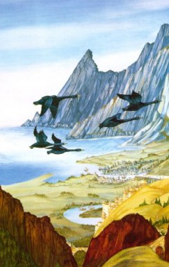
Edhellond |
Edhellond
by John Howe
|
 Elf
haven and settlement on the Bay
of Belfalas. Edhellond was located on the Blackroot
River near the point where it was joined by the Ringlo.
The Blackroot then emptied into Cobas
Haven, a small inlet on the Bay of Belfalas. Edhellond was about 50
miles north of Dol Amroth, also located on Cobas
Haven. Edhellond was in the land of Gondor, but
it was under the control of Elves.
Elf
haven and settlement on the Bay
of Belfalas. Edhellond was located on the Blackroot
River near the point where it was joined by the Ringlo.
The Blackroot then emptied into Cobas
Haven, a small inlet on the Bay of Belfalas. Edhellond was about 50
miles north of Dol Amroth, also located on Cobas
Haven. Edhellond was in the land of Gondor, but
it was under the control of Elves.
The site where Edhellond was founded was originally inhabited by fisher-folk, but they fled to the White Mountains when the Elves arrived. The Elf haven was established by Sindarin Elves. There are differing accounts of when the Elves arrived. They may have come in three ships from Beleriand after the havens of Brithombar and Eglarest were destroyed by Morgoth's forces in the year 473 of the First Age. Or the Elves may have come at the beginning of the Second Age from the Grey Havens, where they had learned the craft of shipbuilding before seeking a place of their own.
The Sindarin Elves were soon joined by some Silvan Elves, or Wood-elves. These Wood-elves came down the Anduin from the forests on either side of the Great River called Greenwood and Lothlorien. They left their forest homes because they longed for the Sea.
From Edhellond, Elves could sail to the Undying Lands. Some Elves departed from Edhellond after Eregion was destroyed by Sauron in 1697 of the Second Age. According to one story, Galadriel came to live for a time on the coast of the Bay of Belfalas because she was filled with Sea-longing, but she remained in Middle-earth.
Over time, the population of Edhellond diminished as many of the Elves who lived there departed across the Sea. But some remained, building ships and offering passage to those who had become weary of Middle-earth.
In 1981 of the Third Age, King Amroth of Lothlorien came to Edhellond. He had promised to take his lover Nimrodel to the Undying Lands, but he had become separated from her on the journey south. When Amroth arrived, the few remaining Elves of Edhellond - less than a shipload - were preparing their last ship to depart from Middle-earth. Though they were reluctant to delay, the Elves of Edhellond agreed to wait a few weeks for Nimrodel, but she did not come.
In the autumn, a great storm came out of the north and swept the ship out into the Bay of Belfalas. Amroth leaped overboard in an attempt to return to land, and he was drowned. But the ship survived and continued its voyage across the Sea, and with it went the last of the Elves of Edhellond.
Names &
Etymology:
Edhellond means "elf haven"
from edhel meaning "elf" and lond meaning "haven."
Sources:
Map of Middle-earth
by Pauline Baynes
The Fellowship
of the Ring: "Lothlorien," p. 355
The Return
of the King: "The Last Debate," p. 148
Unfinished
Tales: "The History of Galadriel and Celeborn," p. 240-43, 246-48,
255 note 18, 261 footnote
The Silmarillion:
"Appendix - Elements in Quenya and Sindarin Names," entries for edhel
and
londe
The History
of Middle-earth, vol. VII, The Treason of Isengard: "The First Map,"
p. 312, 322 note 10 (Cobas Haven)
The History
of Middle-earth, vol. XII, The Peoples of Middle-earth: "The Heirs
of Elendil," p. 220-24; "Of Dwarves and Men," p. 313, 329 note 67
"The Adventures
of Tom Bombadil" in A Tolkien Reader: "Preface," p. 193; "The Last
Ship," p. 248-51
Names &
Etymology:
The name Ethring seems to
refer to the town's position at the crossings of the Ringlo. The word ath
means
"across." The word athrad means "ford, crossing"; the plural is
ethraid.
The word ring means "cold" as in Ringlo, meaning "cold flood."
Sources:
The Return
of the King: Map of Gondor by Christopher Tolkien
The History
of Middle-earth, vol. V, The Lost Road and Other Writings: "The Etymologies,"
entries for AT(AT) and RINGI
During the War of the Ring at the end of the Third Age, Corsairs of Umbar and Men of Harad came up the Gilrain to Linhir and fought to gain control of the fords against Men from Lamedon led by Angbor. On March 11, 3019, Aragorn arrived at Linhir leading the Dead. The Corsairs and Haradrim fled in fear, as did all of the Men of Lamedon except Angbor. Aragorn told Angbor to gather his forces and follow him to Pelargir, where the Corsairs had assembled a great fleet.
Names &
Etymology:
The element lin means both
"pool" and "song." It's not clear which meaning is intended in the name
Linhir.
The element hir is the lenited form of sir meaning "river."
Sources:
Map of Gondor
and Mordor by Christopher Tolkien
The Return
of the King: "The Last Debate," p. 151
The Lord
of the Rings: A Reader's Companion by Wayne G. Hammond and Christina
Scull: "The Last Debate," p. 587
Osgiliath |
Osgiliath
by Alan Lee
|
 Capital
city in the early days of Gondor. Osgiliath was
located on the Great River Anduin, with
buildings on both banks of the river. Minas
Tirith was about 15 miles from Osgiliath on the western side of the
Anduin. On the eastern side was the land of Ithilien
between the river and the borders of Mordor.
Capital
city in the early days of Gondor. Osgiliath was
located on the Great River Anduin, with
buildings on both banks of the river. Minas
Tirith was about 15 miles from Osgiliath on the western side of the
Anduin. On the eastern side was the land of Ithilien
between the river and the borders of Mordor.
Osgiliath was a large and beautiful city. One of its main buildings was the Dome of Stars, where the chief palantir was kept. The Kings of Gondor ruled from the Great Hall of Osgiliath and they dwelled in the King's House.
Between the two parts of the city was a great stone bridge with towers and houses upon it, and there were a number of lesser bridges as well. On the river banks were landings for the ships that carried people and trade goods up and down the Anduin from Wilderland in the north to the Bay of Belfalas in the south.
A road led through Osgiliath between Minas Ithil (later Minas Morgul) on the east side of the river and Minas Anor (later Minas Tirith) on the west side. The road then continued westward through the Gap of Rohan and turned north to Fornost in the North-kingdom of Arnor. In the early days of Gondor, this was called the Royal Road, later known as the Great West Road and the North-South Road.
Osgiliath was founded by Isildur and Anarion, the sons of Elendil, when the realm of Gondor was established in 3320 of the Second Age. Elendil, the High King, dwelled in the North-kingdom of Arnor while his sons jointly ruled Gondor in the south. Their thrones were side by side in the Great Hall of Osgiliath.
Anarion defended Osgiliath when Sauron attacked Gondor in 3429 and drove him back to Mordor. Sauron was defeated in the War of the Last Alliance in 3441. In the Third Age, Anarion's descendants became the Kings of Gondor and for a time they continued to rule from Osgiliath.
During the civil war of the Kin-strife, King Eldacar was besieged in Osgiliath by rebels. Osgiliath was captured in 1437 and the rebels burned and pillaged the city and slaughtered many of its inhabitants including Eldacar's son Ornendil. The Dome of Stars was destroyed and the palantir was lost in the waters of the Anduin. The rebel leader Castamirusurped the throne of Gondor and moved his capital to Pelargir. He ruled for 10 years before Eldacar defeated him in 1447 and took up the kingship again in Osgiliath.
The Great Plague came out of the East in 1636 and devastated Gondor. Osgiliath was hit the hardest. Many of the city's inhabitants died including King Telemnar and all his children. Telemnar's nephew Tarondor became king and in 1640 he moved the capital of Gondor from Osgiliath to Minas Anor - later known as Minas Tirith.
Some people remained in Osgiliath, but the city was largely abandoned and it began to fall into ruin. In 2475, black Uruks from Mordor invaded Ithilien and captured Osgiliath. The Uruks were driven back by Boromir, son of the Denethor I (not to be confused with Boromir of the Fellowship), but the city of Osgiliath was ruined and the great bridge across the Anduin was broken. The remaining inhabitants fled and the city stood empty.
By the 2900s, Ithilien was infested with Orcs and evil things lurked in Osgiliath. Control of the city had passed back and forth between Gondor and Mordor several times. After Denethor II became Steward in 2984, he reclaimed Osgiliath and posted a garrison there. The bridge was rebuilt to allow soldiers and supplies to cross the river.
On June 20, 3018, the War of the Ring began when the Lord of the Nazgul led an attack on Osgiliath. None could withstand his evil presence, and the eastern part of the city was swiftly captured. Denethor's sons Boromir and Faramir led the defense of Osgiliath, and they cast down the bridge and held the western side of the city against the Enemy's forces. But Sauron's purpose in ordering the attack had been to test Gondor's defenses and to provide cover for the Nazgul to cross the bridge begin the hunt for the One Ring. Once that was accomplished, Sauron halted the assault.
The garrison in West Osgiliath continued to guard the river crossing. At midnight on February 29, 3019, Faramir was keeping watch on the riverbank when he saw the funeral boat of his brother Boromir float down the Anduin through Osgiliath. On March 10, Faramir sent the majority of his company of Rangers to strengthen the garrison of Osgiliath. The next day, Denethor sent Faramir to take command of the garrison, where he believed the main attack would come.
Sauron's forces in East Osgiliath had secretly been building many barges and floating bridges and siege-towers in preparation for the assault. On March 12, a host of Orcs arrived from Minas Morgul led by the Lord of the Nazgul, joined by regiments of Haradrim from the South. They crossed the river in force, and Faramir and his Men retreated from Osgiliath with great loss.
Sauron's forces overran the Rammas Echor and besieged Minas Tirith. During the Battle of the Pelennor Fields on March 15, fresh Enemy troops were stationed in Osgiliath including Easterlings, Southrons, Variags, and Men of Far Harad. They were sent onto the battlefield by Gothmog, and the battle began to turn in favor of the Enemy forces, but they were ultimately defeated.
All available workers and craftsmen were sent from Minas Tirith to Osgiliath to strengthen the defenses and rebuild the boats and bridges that Sauron's forces had left behind. On March 18, the Host of the West passed through Osgiliath and over the river on their way to the Black Gate.
After the downfall of Sauron, the Host of the West returned to Osgiliath on April 29. They spent the day and night in the city before proceeding to Minas Tirith, where Aragorn was crowned King Elessar on May 1. Minas Tirith remained the capital of Gondor during the reign of King Elessar, but it seems likely that the city of Osgiliath was rebuilt.
Names &
Etymology:
Osgiliath means "Citadel
of the Stars" from the Sindarin words ost meaning "fortress, citadel"
and giliath meaning "stars."
In later days, Osgiliath was called Old Gondor because it had once been the capital of Gondor. The two halves of the city were called East Osgiliath and West Osgiliath.
Sources:
The Fellowship
of the Ring: "The Council of Elrond," p. 257-59; "Farewell to Lorien,"
p. 383; "The Great River," p. 406; "The Breaking of the Fellowship," p.
417
The Two
Towers: "The Departure of Boromir," p. 19; "The Palantir," p. 203;
"The Black Gate Is Closed," p. 249; "Of Herbs and Stewed Rabbit," p. 256;
"The Window on the West," p. 274, 286; "Journey to the Cross-roads," p.
311; "The Stairs of Cirith Ungol," p. 316
The Return
of the King: "Minas Tirith," p. 22, 36-37; "The Siege of Gondor," p.
85, 87-91, 93, 96, 98; "The Battle of the Pelennor Fields," p. 121; "The
Last Debate," p. 158; "The Black Gate Opens," p. 160; "The Field of Cormallen,"
p. 235; "The Steward and the King," p. 241-42
The Silmarillion:
"Of the Rings of Power and the Third Age," p. 291-93, 297; "Appendix -
Elements in Quenya and Sindarin Names," entries for gil and os(t)
Unfinished
Tales: "The Battles of the Fords of Isen," p. 369-70; "The Istari,"
p. 401 note 7
The History
of Middle-earth, vol. XII, The Peoples of Middle-earth: "The Heirs
of Elendil," p. 203-4
Pelargir |
Pelargir
by Roger Garland
|
 Port
city in Lebennin in Gondor.
Pelargir was located at the junction of the River
Sirith and the Anduin. It was about
110 miles northeast of the point where the Anduin emptied into the
Bay
of Belfalas. The South Road led
from Minas Tirith to Pelargir - a distance
of 42 leagues (126 miles). A road continued westward from Pelargir for
93 leagues (279 miles) to the Hill
of Erech.
Port
city in Lebennin in Gondor.
Pelargir was located at the junction of the River
Sirith and the Anduin. It was about
110 miles northeast of the point where the Anduin emptied into the
Bay
of Belfalas. The South Road led
from Minas Tirith to Pelargir - a distance
of 42 leagues (126 miles). A road continued westward from Pelargir for
93 leagues (279 miles) to the Hill
of Erech.
Pelargir was built in 2350 of the Second Age. It was the haven of the Faithful of Numenor, who did not fall under the influence of Sauron and remained friendly with the Elves. Adunaic - the language of Numenor - was spoken in Pelargir and it became mingled with the languages of other Men and developed into the Common Speech, which spread throughout Middle-earth.
In the Third Age, Tarannon Falastur - the first of the Ship-kings of Gondor - built a house in Pelargir that stood on arched columns out in the waters of the Anduin. Tarannon's nephew and heir, Earnil I, made repairs to Pelargir and built a great navy there.
When the civil war of the Kin-strife began in 1432, many of the people of Pelargir supported Castamir, the Captain of Ships who claimed kingship of Gondor. Castamir usurped the throne from King Eldacar in 1437 and made Pelargir his capital. In 1447, Eldacar killed Castamir in battle and reclaimed the throne. Castamir's sons were besieged in Pelargir, where they gathered many of their followers before relocating to Umbar.
In 1634, Castamir's grandsons Angamaite and Sangahyando led a fleet of Corsairs from Umbar to attack Pelargir. King Minardil of Gondor was slain in the battle.
In 2980, during the reign of Ecthelion II, a fleet from Gondor was assembled at Pelargir to launch an attack on the Corsairs of Umbar. The leader was a man called Thorongil, who was actually Aragorn serving the Steward under an assumed identity. The attack was successful and the threat from the Corsairs was removed for the time being.
But during the War of the Ring, the threat was renewed and under Sauron's direction the Corsairs captured Pelargir and assembled a fleet of 50 great ships and numerous smaller ships to attack Minas Tirith. Aragorn learned of this threat when he looked into the palantir, and he entered the Paths of the Dead to summon the Dead to stop the Corsairs. On March 13, Aragorn reached Pelargir, and the Dead swept over the Corsairs' ships and captured the fleet. Aragorn used these ships to come to the aid of Minas Tirith at the Battle of the Pelennor Fields on March 15.
Names &
Etymology:
Pelargir means "Garth of
Royal Ships." A garth is an enclosure or guarded place. The word pel
means "go round, encircle." The element ar means "royal." The element
gir
is a form of kir meaning "cut, cleave" - used to mean ship as in
cutter.
Sources:
The Return
of the King: "The Passing of the Grey Company," p. 63; "The Last Debate,"
p. 149-54, 157; "The Steward and the King," p. 249
Appendix
A of The Lord of the Rings: "Gondor and the Heirs of Anarion," p. 325,
327-28; "The Stewards," p. 335-36
Appendix
B of The Lord of the Rings: "The Tale of Years," p. 364, 367, 374
Appendix
F of The Lord of the Rings: "The Languages and Peoples of the Third
Age - Of Men," p. 406-407
The Silmarillion:
"Akallabeth," p. 267; "Appendix - Elements in Quenya and Sindarin Names,"
entries for kir and pel; Index entry for Pelargir
Unfinished
Tales: "The Istari," p. 401-402 note 7
The city was home to a group of seafaring raiders known as the Corsairs. They were descended from the sons of Castamir and his followers who had rebelled against King Eldacar of Gondor during the Kin-strife. The rebels came to Umbar in 1448 of the Third Age. They mingled with the native inhabitants, who in turn were descendants of the Haradrim and the Black Numenoreans (Men of Numenor corrupted by Sauron).
The Corsairs were enemies of the Men of Gondor and they frequently raided Gondor's coasts. In 1810, King Telumehtar of Gondor retaliated by capturing Umbar and destroying the Corsairs' stronghold. In the years that followed, Gondor was distracted by other concerns and the Corsairs were able to reclaim Umbar and rebuild their stronghold.
In 2980, Aragorn launched a surprise attack on Umbar and fought the Captain of the Haven on the quays. The Captain was slain and many of the Corsairs' ships were burned. But the Corsairs were not subdued until the War of the Ring when Aragorn captured their fleet at Pelargir with the help of the Dead.
Names &
Etymology:
Corsair is another word for
"pirate."
Sources:
Map of
Middle-earth by Pauline Baynes
Appendix
A of The Lord of the Rings: 327-29; "The Stewards," p. 335
The History
of Middle-earth, vol. XII, The Peoples of Middle-earth: "The Heirs
of Elendil," p. 200
Caras Galadhon |
 City
of the Elves of Lothlorien.
Caras Galadhon was a city in the trees. The Elves dwelled on a network
of platforms called flets among
the tree branches. The city was filled with light and music and it was
home to Celeborn
and Galadriel,
the Lord and Lady of Lothlorien.
City
of the Elves of Lothlorien.
Caras Galadhon was a city in the trees. The Elves dwelled on a network
of platforms called flets among
the tree branches. The city was filled with light and music and it was
home to Celeborn
and Galadriel,
the Lord and Lady of Lothlorien.
Caras Galadhon was located in the part of the forest called the Angle, between the Silverlode and the Anduin. The city was on a hill surrounded by a deep moat and a high green wall. A road paved with white stone ran along the outer edge of the moat to a bridge on the southwestern side that led to the city gates.
Within the city on the slopes of the hill stood many tall mallorn-trees with numerous flets in their branches. Caras Galadhon was the only place in Lothlorien where so many flets were used as dwellings. A number of Elves lived in Caras Galadhon, but the majority of the Elves of Lothlorien lived in the forest outside the city.
Paths and stairs led among the trees and up the hill. High on the hill was a wide lawn. On the southern side of the lawn stood the largest of the mallorn-trees where Galadriel and Celeborn dwelled. There were a number of flets in this tree connected by a long white ladder. On one of the highest flets was a great hall with an oval-shaped chamber around the trunk of the tree. The walls were green and silver and the roof was golden. Higher up in the tree was the topmost flet which was the highest point in Lothlorien.
There was a fountain on the lawn from which a stream flowed southward down the hill to a deep hollow. A long flight of steps led down into an enclosed garden where the Mirror of Galadriel stood. Galadriel filled the Mirror with water from the stream.
The Fellowship came to Caras Galadhon on January 17, 3019 of the Third Age. Frodo Baggins first saw Caras Galadhon from the summit of Cerin Amroth, and it seemed to him that the power and light of Lothlorien emanated from the city where Galadriel dwelled.
The Fellowship met with Galadriel and Celeborn in their great hall. A pavilion was set up on the lawn and the Fellowship stayed there for a month. At the end of their stay, Frodo and Sam visited Galadriel's garden and looked into the Mirror. The Fellowship left Caras Galadhon and they departed from Lothlorien on February 16.
After the War of the Ring in the year 3021, Galadriel left Middle-earth. Celeborn remained in Lothlorien for a time but eventually he moved to Rivendell. In the Fourth Age, few Elves remained in Lothlorien and there was no longer light and music in Caras Galadhon.
Names
& Etymology:
Also
called the City of the Trees.
Caras was an old word meaning "moated fortress," probably from the Silvan dialect. In Sindarin, caras means "city." The word galadh means "tree."
Sources:
The
Fellowship of the Ring: "Lothlorien," p. 361, 366; "The Mirror of Galadriel,"
p. 368-69, 372, 376 and passim; "Farewell to Lorien," p. 386-87
Unfinished
Tales: "The History of Galadriel and Celeborn," p. 246, 257, 261, 267
Appendix
B of The Lord of the Rings:
"The Tale of Years," p. 375
The
History of Middle-earth, vol. V, The Lost Road and Other Writings:
"The Etymologies," entries for GALAD and KAR, KYAR
Belegost and Nogrod |
Map
of Belegost and Nogrod
|
 Cities
of the Dwarves in the Blue Mountains
in ancient times and the First Age. Belegost and Nogrod were located near
Mount
Dolmed which was around the midpoint of the mountain range. Belegost
was north of Mount Dolmed and Nogrod was to the south.
Cities
of the Dwarves in the Blue Mountains
in ancient times and the First Age. Belegost and Nogrod were located near
Mount
Dolmed which was around the midpoint of the mountain range. Belegost
was north of Mount Dolmed and Nogrod was to the south.
The Blue Mountains formed the border between Beleriand to the west and Eriador to the east. Belegost and Nogrod were on the eastern side of the mountains. There were passes over the Blue Mountains near Belegost and Nogrod, and the Dwarf-road came down from the passes into Beleriand. The Dwarf-road ran through Thargelion alongside the Ascaron the northern border of Ossiriand. The road crossed the Gelion at Sarn Athrad.
According to legend, two of the Seven Fathers of the Dwarves awoke beneath the Blue Mountains. These were the fathers of the Firebeards and the Broadbeams. It is not known when the Dwarves awoke, but it was after the awakening of the Elves in 1050 of the Years of the Trees. The Dwarves established the cities of Belegost and Nogrod and delved great mansions and halls under the mountains.
Around 1250 of the Years of the Trees, the Dwarves of Belegost and Nogrod came into Beleriand and encountered the Sindarin Elves who lived there. The Dwarves learned the language of the Elves but did not share their own tongue.
The Dwarves of Belegost and Nogrod were skilled craftsmen. They did metalwork in iron and copper, and they were unrivalled in the art of tempering steel. The Dwarves of Nogrod were the most skilled at making arms, while the Dwarves of Belegost invented the process of making chain mail. The Dwarves traded with the Elves and taught them some of their skills.
Around 1300 of the Years of the Trees, the Dwarves of Belegost helped build the Thousand Caves of Menegroth for the Elvenking Thingol of Doriath. They carved numerous halls, chambers, and passages underground. In exchange, the Dwarves of Belegost were taught wisdom by Thingol's wife Melian who was a Maia from the Undying Lands. From Thingol they received pearls from the Isle of Balar including a large, beautiful pearl called Nimphelos that was highly prized by the chieftain of Belegost.
During this period, Morgoth was being held captive by the Valar. But the Dwarves warned Thingol that evil things were roaming east of the Blue Mountains. Around 1330, some of these creatures including Orcs began to enter Beleriand. Thingol asked the Dwarves of Nogrod and Belegost to make weapons for his people and the Elves temporarily drove the creatures back.
Morgoth returned to Middle-earth and invaded Beleriand. In the First Battle in 1497, Thingol drove the Orcs from East Beleriand and the Dwarves waylaid those who tried to flee north to Angband. Soon afterwards, the Noldor led by Feanor came to Middle-earth to retrieve the Silmarils Morgoth had stolen. The Dwarves of Belegost and Nogrod stopped their traffic into Beleriand at this time.
The Dwarves of Belegost and Nogrod encountered Feanor's son Caranthir and his people who settled near the Blue Mountains. The Noldorin Elves were skilled craftsmen like the Dwarves. The Dwarves did not particularly like Caranthir but they exchanged knowledge with the Noldor and resumed trade into Beleriand. The Dwarves prized the jewels of the Noldor above all other treasures.
Around the year 52 of the First Age, the Dwarves helped Finrod build the underground stronghold of Nargothrond in exchange for treasures that Finrod had brought from the Undying Lands. Craftsmen of Belegost and Nogrod also made the Nauglamir - the Necklace of the Dwarves - for Finrod. The Nauglamir was made of gold and set with many jewels and it was the most famous work of the Dwarves at that time.
The most renowned smith of Nogrod was Telchar who learned his craft from Gamil Zirak. Telchar made Narsil which eventually belonged to Elendil many milliennia later and then became Anduril, the sword of Aragorn. Telchar also made the Dragon-helm for Azaghal, the Lord of Belegost, shortly after the Dragon Glaurung appeared in the year 260.
At some point, Azaghal was waylaid by Orcs while travelling along the Dwarf-road in East Beleriand. His life was saved by Maedhros, son of Feanor, and Azaghal gave the Dragon-helm to Maedhros. The Dragon-helm later came into the possession of Turin.
Although the Dwarves frequently travelled into Beleriand, few Elves ever went to Belegost and Nogrod except for Eol the Dark Elf. Eol was a smith and he improved his skill at metalwork during the time he spent in the cities of the Dwarves. He invented a hard but malleable black metal named galvorn.
Eol had a son Maeglin, born around 320, who visited Belegost and Nogrod with his father. Around 400, Eol was invited to the customary midsummer feast at Nogrod. While he was away, Maeglin and his mother Aredhel fled to Gondolin where Aredhel's brother Turgon ruled. Eol pursued them and was slain, and Maeglin was later instrumental in the downfall of Gondolin.
Around 468, Maedhros formed an alliance against Morgoth. The Dwarves of Belegost and Nogrod joined the Union of Maedhros and they provided many weapons. Azaghal, Lord of Belegost, led an army to the Battle of Unnumbered Tears in 472.
The Dwarves of Belegost were the last to stand firm during an assault by Orcs, wolves, Balrogs, traitorous Men, and Dragons led by Glaurung. The masks worn by the Dwarves protected them from the Dragons' fire. Azaghal was mortally wounded by Glaurung but managed to stab the Dragon before he died, forcing Glaurung to withdraw from the battle. The Dwarves of Belegost ceased fighting and they carried Azaghal's body away.
The Battle of Unnumbered Tears was a crushing defeat to the enemies of Morgoth. After the battle, the Dwarves continued to travel into Beleriand though they brought large armed companies with them for protection. They often visited Menegroth to do work for Thingol in smithies set aside for their use.
Around 502, Thingol asked a group of Dwarf-smiths from Nogrod to set one of the Silmarils in the Nauglamir. The Dwarves coveted the Silmaril and the necklace that had been made by their ancestors, and when the work was completed they killed Thingol and took the Nauglamir. They fled from Menegroth but the Elves of Doriath pursued them and slew the Dwarves and took back the Nauglamir.
Two of the Dwarves escaped and returned to Nogrod. They falsely claimed that Thingol had ordered the slaying of their companions in order to avoid paying them for their work. The Dwarves of Nogrod were incensed and they planned to seek revenge on the Elves of Doriath. The Dwarves of Belegost refused to help and tried to dissuade the Dwarves of Nogrod but to no avail.
Around 503, the Dwarves of Nogrod invaded Doriath with a great force. Many Dwarves were killed but they defeated the Elves and took the Nauglamir set with the Silmaril along with many other treasures. On the way back to Nogrod, the Dwarves were ambushed at Sarn Athrad by the Elves of Ossiriand led by Beren - the husband of Thingol's daughter Luthien - and his son Dior.
Beren killed the Lord of Nogrod and reclaimed the Nauglamir. The Lord of Nogrod cursed the treasure with his dying words. The rest of the treasures of Doriath were sunk to the bottom of the River Ascar, but Beren kept the Nauglamir with the Silmaril to give to Luthien.
Most of the other Dwarves were also slain in the battle. The few that escaped were waylaid by the Ents on the slopes of Mount Dolmed and none of them ever returned to Nogrod.
During the War of Wrath at the end of the First Age, Beleriand was destroyed and the Blue Mountains were broken. Belegost and Nogrod were ruined. Some Dwarves stayed in what remained of the Blue Mountains, but many others migrated eastward to the Misty Mountains. Around the year 40 of the Second Age they joined the Dwarves of Khazad-dum and they enriched that great realm with their knowledge and skills.
Names &
Etymology:
The name Belegost means "great
fortress" in Sindarin from beleg meaning "mighty" and ost
meaning "fortress." The Dwarvish name was Gabilgathol from gabil
meaning "great" and gathol meaning "fortress." Another name was
Mickleburg
where mickle is from the Old English micel meaning "great,
many" and burg means "fortress, walled town." This is apparently
Common Speech though that language did not exist at the time.
The earlier version of the name Nogrod was Novrod meaning "hollow dwelling" from the Common Eldarin words naba meaning "hollow" and (g)rota meaning "excavation, underground dwelling." The name evolved into Nogrod with Nog derived from the Sindarin Naug meaning "Dwarf." The Dwarvish name was Tumunzahar and the Common Speech rendering was Hollowbold. The word bold means "dwelling" in Old English.
Sources:
The Silmarillion:
"Of the Sindar," p. 91-96; "Of the Return of the Noldor," p. 112-14; "Of
Maeglin," p. 133-34; "Of Beren and Luthien," p. 177; "Of the Fifth Battle,"
p. 189-90, 193; "Of Turin Turambar," p. 204; "Of the Ruin of Doriath,"
230-37; Index, entries for Belegost and Hollowbold (Nogrod);
"Appendix - Elements in Quenya and Sindarin Names," entries for
beleg
and os(t)
The History
of Middle-earth, vol. XI, The War of the Jewels: "The Grey Annals,"
p. 9-13, 45-46, 70-71, 75; "The Later Quenta Silmarillion," p. 211-12;
"The Tale of Years," p. 347, 350; "Quendi and Eldar," p. 388-89, 408, 414
(Novrod)
The History
of Middle-earth, vol. XII, The Peoples of Middle-earth: "Of Dwarves
and Men," p. 301, 322 note 24
Unfinished
Tales: "Narn I Hin Hurin," p. 75-76, 128, 146 note 4; "The History
of Galadriel and Celeborn," p. 235, 252 notes 3 and 4
Appendix
A of The Lord of the Rings: "Durin's Folk," p. 352
Appendix
B of The Lord of the Rings: "The Tale of Years," p. 364
Khuzdul
- The Secret Tongue of the Dwarves
Old English
Goblin-town was dark and the air was stuffy. There was a great cavern lit with a red fire where the Great Goblin sat on a stone slab. Most of the tunnels of Goblin-town had been carved by the Orcs though they incorporated some pre-existing caves and passages. The tunnels branched in many directions and extended deep under the mountains.
One tunnel ran down to the subterranean lake where Gollum lived, but the Orcs seldom went there unless the Great Goblin sent them to catch fish. There was also a low passageway that sloped up and down until it reached a stone door called the back-door or Goblin-gate on the east side of the Misty Mountains.
In 2941, Thorin & Company were captured by Orcs in the Front Porch and were brought to Goblin-town. Gandalf killed the Great Goblin and the Dwarves escaped but Bilbo Baggins became lost in the tunnels. Bilbo found the One Ring and encountered Gollum before he was able to escape through the back-door.
Names &
Etymology:
The word Goblin is synonymous
with Orc in Tolkien's writings.
Sources:
The Hobbit:"Over
Hill and Under Hill," passim; "Riddles in the Dark," p. 79-83, 95-100;
"Out of the Frying-pan into the Fire," p. 102-105
Names &
Etymology:
The meaning of Almaida is
unknown. The name was written unclearly on a map of Numenor made by J.R.R.
Tolkien.
Sources:
Unfinished
Tales: Introduction, p. 7
Andúnië |
Map
of Andúnië in Numenor
(Note: Locations of Almaida and Oromet approximated.) |
 City
and haven on the west coast of
Numenor. Andunie
was located on the Bay of Andunie in the Westlands of Andustar - the northwestern
promontory of the island of Numenor. At the head of the Bay was a shelf
of land at the foot of a steep slope. The city of Andunie was on the land
at the water's edge and there were also some buildings on the slopes above.
City
and haven on the west coast of
Numenor. Andunie
was located on the Bay of Andunie in the Westlands of Andustar - the northwestern
promontory of the island of Numenor. At the head of the Bay was a shelf
of land at the foot of a steep slope. The city of Andunie was on the land
at the water's edge and there were also some buildings on the slopes above.
Near Andunie was the hill of Oromet where Tar-Minastir built a tower to look westward toward the Undying Lands. Just west of Andunie there was another haven on the Bay of Andunie called Almaida. South of the Bay of Andunie was the large Bay of Eldanna where the haven of Eldalonde was located. The main road in Numenor connected Andunie with Armenelos and Romenna on the east side of the island.
Andunie was an important port city. Numenorean ships harbored at Andunie and ships of the Elves came there from the Undying Lands in the West. The people of Andunie and the Westlands commonly spoke Sindarin as their native tongue, while in the rest of Numenor the native language was Adunaic (though many also knew Sindarin).
The first Lord of Andunie was Valandil whose mother Silmarien was the daughter of Tar-Elendil, the fourth King of Numenor. The Lords of Andunie were the highest ranking nobles in Numenor after the members of the royal house. They served on the Council of the Sceptre and advised the Kings and Queens of Numenor.
Andunie was home to many of the Faithful who remained friendly with the Elves and loyal to the Valar while most other Numenoreans became estranged from them. The Lords of Andunie were secretly leaders of the Faithful though they continued to counsel and serve the rulers.
During the reign of Ar-Gimilzor from 3102 to 3175 of the Second Age, the Faithful were forced to relocate from Andunie and the Westlands to Romenna in the east where the King's Men could keep an eye on them. The Elves were not welcome in Numenor and their ships no longer came to Andunie.
In 3310, Ar-Pharazon began to build the Great Armament in order to assail the Undying Lands in a misguided attempt to gain immortality. Andunie became the chief harbor for the King's fleet. Ar-Pharazon launched his attack in 3319 and Numenor was destroyed by Eru. Elendil - the son of Amandil, last Lord of Andunie - escaped with the Faithful to Middle-earth and founded the Kingdoms of Gondor and Arnor.
Names &
Etymology:
The name Andúnië
means "sunset" in Quenya. The city was so named because it faced the west.
Sources:
Unfinished
Tales: "Introduction," p. 7; "A Description of the Island of Numenor,"
p. 167, 169; "Aldarion and Erendis," p. 173, 182, 185, 189, 193, 214 note
8, 215 notes 15 and 19, 216-17 note 23; "The Line of Elros: Kings of Numenor,"
p. 219-20, 223
The Silmarillion:
"Akallabeth," p. 261, 268-69, 271, 277; "Appendix - Elements in Quenya
and Sindarin Names," entry for andune
The History
of Middle-earth, vol. XII, The Peoples of Middle-earth: "The History
of the Akallabeth," p. 162
Appendix
A of The Lord of the Rings: "The Numenorean Kings," p. 316
The city of Armenelos was built on a hill. The citadel and tower of the King's Court were located there. At the top of the tower was the eyrie of two Eagles sacred to the Vala Manwe. In the King's Court grew Nimloth, the White Tree given to the Men of Numenor by the Elves.
Armenelos was founded by Elros in the year 32 of the Second Age when the Edain arrived in Numenor. It became a glorious and thriving city. But signs of the growing estrangement of the Men of Numenor from the Valar and the Elves became evident in Armenelos. The Eagles that dwelled in the tower of the King's Court left their eyrie during reign of Tar-Ancalimon (2251-2386).
In the time of Ar-Pharazon (3255-3319), Nimloth was cut down at the urging of Sauron, who had come to Numenor as a prisoner but had insinuated himself into the King's inner circle. Sauron built a great temple in the center of Armenelos. The temple was circular with walls that were 50 feet thick. It was 500 feet across and 500 feet high topped with a silver dome. Nimloth was burned in the temple and afterwards the altar was used for human sacrifices.
Armenelos was lost when the island of Numenor sank beneath the Sea in 3319.
Names &
Etymology:
The name Armenelos contains
the Quenya words ar meaning "royal" and menel meaning "heaven"
and possibly os from osto meaning "fortress, city." Also
called the City of the Kings and Armenelos the Golden.
Sources:
Unfinished
Tales: "A Description of the Island of Numenor," p. 165, 169; "Aldarion
and Erendis," p. 173, 175-77, 181, 183-86, 189-90, 192-93, 195-99,
201, 203-5,
208; "The Line of Elros: Kings of Numenor," p. 218
The Silmarillion:
"Akallabeth," p. 261, 263, 270-73; "Of the Rings of Power and the Third
Age," p. 291
The
Quenya Corpus Wordlist
Names &
Etymology:
The name Eldalondë means
"Haven of the Eldar" in Quenya. The word Eldar (singular, Elda)
means "People of the Stars" signifying the Elves, particularly those who
made the Great Journey. The world londë means "haven." Also
called Eldalondë the Green.
Sources:
Unfinished
Tales: "A Description of the Island of Numenor," p. 167-68; Index entry
for Eldalonde
The Silmarillion:
"Appendix
- Elements in Quenya and Sindarin Names," entries for el, elen and
londe
Names &
Etymology:
The name Nindamos appears
to contain the word nîn meaning "wet" probably because of
the village's location on the marshy shore.
Sources:
Unfinished
Tales: Map of Numenor; "A Description of the Island of Numenor," p.
168
Romenna |
Map
of Romenna
|
 Port
city in eastern Numenor. Romenna was located
in the region of Arandor about 50 miles east of the capital city of Armenelos.
The port stood on the south side of the Firth of Romenna which opened onto
the Bay of Romenna and then onto the Sea. The main road of Numenor ran
from Romenna through Armenelos past Meneltarma
and on to Andunie on the west coast.
Port
city in eastern Numenor. Romenna was located
in the region of Arandor about 50 miles east of the capital city of Armenelos.
The port stood on the south side of the Firth of Romenna which opened onto
the Bay of Romenna and then onto the Sea. The main road of Numenor ran
from Romenna through Armenelos past Meneltarma
and on to Andunie on the west coast.
Romenna was the greatest port in Numenor. There were large shipyards in Romenna and the most highly skilled shipwrights worked there. The mariner Veantur had a house with its own quay in Romenna and Aldarion frequently came there and kept his ships in the harbor.
Tar-Meneldur closed the shipyards in Romenna during a dispute with his son Aldarion in 829 of the Second Age. The shipyards were reopened in 843 and Aldarion repaired and expanded the harbor works and built sea-walls. Aldarion's wife Erendis died in the water at Romenna in 985.
During the reign of Ar-Gimilzor (3102-3175), many of the Faithful of Numenor were forced to relocate from Andunie to Romenna so the King's Men could keep watch on them. More were drawn there by Amandil, the leader of the Faithful during the reign of Ar-Pharazon. When Numenor was destroyed in 3319, the Faithful led by Elendil boarded ships at Romenna and escaped to Middle-earth.
Names &
Etymology:
The name Romenna means "eastwards"
in Quenya from rómen meaning "east" and the suffix -(n)na
indicating movement towards.
Sources:
Unfinished
Tales: Map of Numenor; "A Description of the Island of Numenor," p.
165, 169; "Aldarion and Erendis," p. 174-75, 179-82, 186, 191-92, 195,
201, 212; Index entries for Eldanna (-nna suffix) and Romenna
The Silmarillion:
"Akallabeth,"
p. 268, 272-73, 275, 279; "Appendix - Elements in Quenya and Sindarin Names,"
entry for romen
Edoras |
Edoras
in the New Line film
|
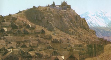 Main
town in Rohan and site of the royal court. Edoras
was located at the foot of the White Mountains,
which formed the southern border of Rohan. The town stood on a green hill
at the mouth of the valley of Harrowdale.
Main
town in Rohan and site of the royal court. Edoras
was located at the foot of the White Mountains,
which formed the southern border of Rohan. The town stood on a green hill
at the mouth of the valley of Harrowdale.
There were many wooden houses on the slopes of the hill. At the summit on a green terrace was Meduseld, the great hall of the Kings of Rohan. There was a spring at the bottom of the terrace that issued from a stone horse's head. From it a stream flowed downhill and alongside a paved road and stone steps descended to the town gate.
Edoras was surrounded by a great wall and thorny fence and a dike. The town was defended by the Muster of Edoras, comprised of Riders from the town itself and the surrounding King's Lands including Harrowdale, as well as nearby parts of the East-mark and West-mark. The Muster of Rohan was the ward of the First Marshal of the Mark. During Theoden's reign, the King himself acted in this capacity, and Elfhelm was the officer in command of the garrison of Edoras.
Before the gate north of the town was the Barrowfield where the Kings of Rohan were buried. There were two rows of barrows covered with grass and white flowers called simbelmyne. The graves of the nine kings of the First Line starting with Eorl were on the western side. On the east the kings of the Second Line were buried. An eighth mound was added to this line in 3019 after the death of King Theoden in the War of the Ring. A third row was begun after the death of King Eomer in 63 of the Fourth Age.
A path ran north from the town gate between the barrows to a ford across the River Snowbourn. The Snowbourn issued from the valley of Harrowdale, flowing past Edoras on the west and then curving around the northern side of the town. The Great West Road came to Edoras from Minas Tirith. This road joined the North-South Road that continued through the Gap of Rohan and north to Eriador.
South of Edoras in the valley of Harrowdale was the refuge of Dunharrow and the entrance to the Paths of the Dead. There were also two small villages in the valley called Underharrow and Upbourn.
The hill that was the site of Edoras was chosen by Eorl after he became the first King of Rohan in 2510 of the Third Age. The hall of Meduseld was completed in the reign of Eorl's son Brego in 2569.
Rohan was invaded by Dunlendings in 2758 and their leader Wulf captured Edoras and set himself up on the throne. In the spring of 2759, Frealaf reclaimed Edoras for the Rohirrim and became King.
On September 19, 3018, Gandalf came to Edoras after escaping imprisonment by Saruman. Gandalf was refused admittance to Edoras by King Theoden, who was under the influence of Saruman's lackey Grima. The next day, Gandalf was allowed to enter Edoras but the King would not listen to his warnings of Saruman's treachery and Gandalf departed.
Gandalf returned to Edoras with Aragorn, Legolas, and Gimli on March 2, 3019. The Wizard freed the King from Saruman's spell, and Theoden decided lead his Riders to war. He was slain at the Battle of the Pelennor Fields on March 15 and his body was brought back to Edoras and buried on August 10. Among the illustrious guests who resided at Edoras during the King's funeral were Faramir,Prince Imrahil, Galadriel, Celeborn, Elrond and his sons, Queen Arwen, and Aragorn, King Elessar.
Eomer became King and moved from his stronghold of Aldburg to Edoras. In the year 63 of the Fourth Age, he sent word to Merry Brandybuck who was a Knight of the Riddermark. Merry and his friend Pippin Took came to Edoras and visited with King Eomer before he died.
Names &
Etymology:
Edoras means "the Courts."
In Old English, eoderas is the plural of eodor meaning "enclosure,
precinct."
Sources:
The Fellowship
of the Ring: "The Council of Elrond," p. 275
The Two
Towers: "The King of the Golden Hall," passim
The Return
of the King: "The Muster of Rohan," p. 64, 66, 75-78; "Many Partings,"
p. 254-56
Appendix
A of The Lord of the Rings: "The House of Eorl," passim
Unfinished
Tales: "The Battles of the Fords of Isen - Appendix," p. 367
Old English
Glossary at Beowulf on Steorarume
Old English
After the Muster of Rohan in Harrowdale on March 10, 3019 of the Third Age, the host of the Mark passed through Underharrow and Upbourn. In both villages, women looked out the doors of their homes as the Riders passed on the way to war.
Names &
Etymology:
Upbourn was so named because
it was located up the river - or bourn - from Edoras. Underharrow was
named for its location below Dunharrow. The word
harrow is from
the Old English hearg meaning "sanctuary."
Sources:
The Return
of the King: "The Muster of Rohan," p. 76
"Nomenclature
of The Lord of the Rings," entry for Upbourn
The Lord
of the Rings: A Reader's Companion by Wayne G. Hammond and Christina
Scull: "The Muster of Rohan," p. 540
Names &
Etymology:
Breredon means "Briar Hill"
from the Old English brere meaning "briar" and don meaning
"down, hill."
Sources:
"The Adventures
of Tom Bombadil" in A Tolkien Reader: Preface, note 3; "Bombadil
Goes Boating," p. 206
Bombadil
in the Shire by Lalaith
The Bucklebury Ferry was one of the two main ways of crossing the river, along with the Brandywine Bridge. There was a landing stage in Bucklebury and one on the opposite bank in the Marish. The ferry-boats were large and flat and long poles were used to push them across the river. The boats were kept on the Bucklebury side.
Merry Brandybuck met Frodo Baggins, Sam Gamgee, and Pippin Took at the landing stage in the Marish on the evening of September 25, 3018 of the Third Age. The Hobbits crossed the river to Bucklebury. Looking back, they saw a Black Rider on the western shore, but there were no boats on that side and the Rider was unable to follow them across the river. The Hobbits passed through Bucklebury and continued to the small village of Crickhollow northeast of Bucklebury where Frodo had bought a house.
Names &
Etymology:
Buck is from the name Buckland
and Brandybuck and bury means "village" in Old English.
Sources:
The Fellowship
of the Ring: Map of "A Part of the Shire"; "A Conspiracy Unmasked,"
p. 108-10
Budgeford was the main residence of the Bolger family. Fatty Bolger and his sister Estella were from Budgeford.
Names &
Etymology:
The element budge is derived
from bulge or bolge, as in the name Bolger. A ford is a shallow
place where a river can be crossed.
Sources:
The Fellowship
of the Ring: Map of "A Part of the Shire"; "A Conspiracy Unmasked,"
p. 118
"Nomenclature
of The Lord of the Rings," entry for Budgeford
The Green Dragon in Bywater was a popular inn for residents of Bywater and Hobbiton as well as for travelers along the Great East Road. Thorin Oakenshield and his company of Dwarves assembled at the Green Dragon in 2941 of the Third Age while awaiting the arrival of their burglar Bilbo Baggins. There was also a post-office in Bywater. In the bank on the north side of Bywater Pool there was a row of Hobbit-holes, and along the road there was an avenue of trees. The most prominent Hobbit in Bywater was Tom Cotton, who had a farm down South Lane.
During the War of the Ring, the trees along the road were cut down by Ted Sandyman and a line of ugly houses were built in their place. The Hobbit-holes in the north bank were deserted and many of the houses had been burned down. The Green Dragon was occupied by ruffians and several of its windows had been broken.
When Frodo Baggins and his companions returned to the Shire and were arrested at Frogmorton on November 1, 3019, the Chief ordered that they be brought to Bywater and handed over to his Men. They set out for Bywater on the morning of November 2, but the four Hobbit adventurers soon outpaced their escort of Shirriffs and went on ahead, saying they'd meet the Shirriffs at the Green Dragon. At the Green Dragon, Merry Brandybuck, Pippin Took, and Sam Gamgee drove off the six ruffians at the inn, but the Men ran toward Hobbiton for reinforcements.
Sam went to Tom Cotton's farm to find the farmer and his sons, while Merry blew the Horn of the Mark and rallied the Hobbits of the Bywater area. Over 200 Hobbits gathered in the center of the village. The Shirriffs who had arrested Frodo and his friends arrived, and many of them joined the ranks of the defenders. Barricades were placed on the road through Bywater. The ruffians from the inn return in a group of 20 Men, but Hobbit archers killed their leader and the rest surrendered and were taken prisoner.
Pippin rode off to Tookland and returned with 100 Hobbits on the morning of November 3. Merry went out scouting in the night and returned to report that 100 Men were heading toward Bywater. Merry orgainzed the Hobbitry and set up a trap on the Bywater Road that the Men walked right into. The Battle of Bywater ensued. In the end, nearly 70 Men were killed and 12 were taken prisoner, while 19 Hobbits died and about 30 were wounded. The dead Men were buried in a nearby sand-pit that came to be called the Battle Pit. The Hobbits were buried separately, and a stone was placed on their grave with a garden around it.
Sources:
The Hobbit:
"Roast Mutton," p. 38
The Fellowship
of the Ring: Map of "A Part of the Shire"; "A Long-Expected Party,"
p. 34; "The Mirror of Galadriel," p. 378
The Return
of the King: "The Scouring of the Shire," p. 280-95
In the summer of 3018 of the Third Age, Frodo Baggins bought a small house in Crickhollow as an excuse for leaving Bag End and the Shire. The house had been built by the Brandybucks for the use of those who wanted peace and quiet. It was set back from the lane behind a hedge with a gate and stood on a wide lawn inside a circle of trees. The house was much like a Hobbit-hole, with only one storey, a turf roof, and round windows and door.
Merry Brandybuck and Fatty Bolger had gone ahead to prepare the house at Crickhollow for Frodo's arrival on September 25, 3018. At Crickhollow, Merry and Pippin Took told Frodo that they intended to accompany him and Sam Gamgee on the quest. The four Hobbits left Crickhollow early the next morning.
Fatty Bolger remained behind to make it appear as though Frodo were still living there. In the early hours of September 30, the house at Crickhollow was attacked by three Nazgul including Khamul. When Fatty saw the shadowy figures approaching he fled out the back door and ran to the nearest house to raise the alarm. The Horn-call of Buckland sounded and the Nazgul fled.
After the War of the Ring, Merry and Pippin lived together at Crickhollow for a time before they assumed their family titles and responsibilities.
Names &
Etymology:
Cryc is a Celtic word meaning
"hill" and a hollow is a small depression in the ground.
Sources:
The Fellowship
of the Ring: "Three Is Company," p. 75-76; "A Conspiracy Unmasked,"
p. 110 and passim; "A Knife in the Dark," p. 188-89
The Return
of the King: "The Grey Havens," p. 305
"Nomenclature
of
The Lord of the Rings," entry for Crickhollow
Elfling
list archives
The Lord
of the Rings: A Reader's Companion by Wayne G. Hammond and Christina
Scull: "A Knife in the Dark," p. 164-7
Names &
Etymology:
The name Deephallow apparently
contains the Old English word hall or healh meaning "corner,
nook" in reference to its location at the juncture of the two rivers.
Source:
The Fellowship
of the Ring: Map of "A Part of the Shire"
The Lord
of the Rings: A Reader's Companion by Wayne G. Hammond and Christina
Scull: "The Maps of The Lord of the Rings," p. lvii
Names &
Etymology:
The name Dwaling appears
related to the word dwelling. However, a note written by Tolkien
suggests that Dwaling was the settlement of someone with the nickname Dwale
meaning "dull" in Old English.
Source:
The Fellowship
of the Ring: Map of "A Part of the Shire"
The Lord
of the Rings: A Reader's Companion by Wayne G. Hammond and Christina
Scull: "The Maps of The Lord of the Rings," p. lviii
Frodo Baggins and his companions were arrested at Frogmorton on November 1, 3019 of the Third Age, by the Shirriffs of the First Eastfarthing Troop. The four Hobbits spent the night in the Shirriff-house at Frogmorton, an ugly, one-storey brick building. They left the next morning accompanied by a dozen Shirriffs but soon left their escort behind.
Names &
Etymology:
Frogmorton is composed of
the elements frog + moor ("marshy land") +
town.
Sources:
The Fellowship
of the Ring: Map of "A Part of the Shire"
The Return
of the King: "The Scouring of the Shire," p. 280-82
"Nomenclature
of The Lord of the Rings," entry for Frogmorton
Names &
Etymology:
Gamwich was called Galabas
in the language of the Hobbits. The name Galabas means "game village"
from the Hobbitish galab meaning "game" and
bas, the equivalent
of the Old English wick or wich meaning "village."
Sources:
Appendix
C of The Lord of the Rings: Gamgee genealogy, p. 383
Appendix
F of The Lord of the Rings: "The Languages and Peoples of the Third
Age," p. 416
The Letters
of J.R.R. Tolkien: Letter #144
Names &
Etymology:
The word holm means "small
island" or "raised land, often surrounded by marshland." The name Greenholm
may be a reference to the village's position on a hill, like a green island
among the downs.
Source:
Appendix
B of The Lord of the Rings: "The Tale of Years," p. 378
On
dalr and holmr in the place-names of Britain by Dr. Gillian Fellows-Jensen
Note:
Tolkien states in his "Nomenclature
of The Lord of the Rings" that Hardbottle was a village in
the Northfarthing, however in his unfinished Index
he describes it as being in the Southfarthing.
Names &
Etymology:
The ending -bottle is from
the Old English botl from which the modern word build is
derived. It means "dwelling." Hardbottle was so named because of
the hard, rocky land where it was built.
Sources:
The Return
of the King: "The Grey Havens," p. 301
"Nomenclature
of The Lord of the Rings," entry for Hardbottle
The Lord
of the Rings: A Reader's Companion by Wayne G. Hammond and Christina
Scull: "The Grey Havens," p. 665
Names &
Etymology:
Haysend was so named because
it was at the end of the Hay.
Sources:
Map of
"A Part of the Shire" by J.R.R. Tolkien
The Fellowship
of the Ring: "A Conspiracy Unmasked," p. 109; "The Old Forest," p.
124
"The Adventures
of Tom Bombadil" in A Tolkien Reader: Preface, note 3; "Bombadil
Goes Boating," p. 204, 206
Hobbiton |
Hobbiton
by J.R.R. Tolkien
|
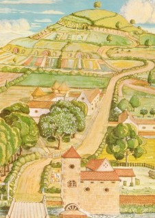 Village
in the Westfarthing of the Shire; home of
Bilbo
and Frodo Baggins. Hobbiton was located on the
Water, about a mile northwest of its neighboring village Bywater.
The Bywater Road passed through both
villages and connected with the Great
East Road to the south.
Village
in the Westfarthing of the Shire; home of
Bilbo
and Frodo Baggins. Hobbiton was located on the
Water, about a mile northwest of its neighboring village Bywater.
The Bywater Road passed through both
villages and connected with the Great
East Road to the south.
The village of Hobbiton spanned both sides of the Water. Some of the dwellings in Hobbiton were smials, or Hobbit-holes, but there were also buildings of wood, brick or stone. One of the main buildings in Hobbiton was Sandyman's Mill, which stood on the north side of the Water by the bridge. The Old Grange was on the west side of the lane that ran from the bridge to the Hill, where Bag End was located. On the southern slope of the Hill were three smaller Hobbit-holes along Bagshot Row. There were a number of other dwellings on the south side of the Water. Hobbiton also had its own post office.
Hobbiton was hit hard during the War of the Ring. Bag End had become the home of Lotho Sackville-Baggins, who had named himself Chief. Rough-looking Men came to Hobbiton at his invitation; at times up to fifty Men were living in sheds in Hobbiton. They tore up trees and hedges, Hobbit-holes and buildings to make way for industry. When Frodo and his companions returned they were stunned by what they saw.
It was one of the saddest hours in their lives. The great chimney rose up before them; and as they drew near the old village across the Water, through rows of new mean houses along each side of the road, they saw the new mill in all its frowning and dirty ugliness: a great brick building straddling the stream, which it fouled with a steaming and stinking overflow. All along the Bywater Road every tree had been felled.The Old Grange had been torn down and replaced with tarred shacks; Bagshot Row had been dug up and turned into a quarry. Bag End itself was in terrible disrepair and there were sheds and piles of garbage in the garden.
The Return of the King: "The Scouring of the Shire," p. 296
After the Scouring of the Shire, Bag End was restored and new holes were dug along Bagshot Row. The new mill was removed. Sam Gamgee spread Galadriel's gift of earth from her orchard around the Shire, paying special attention to Hobbiton and Bywater. He planted the mallorn seed in the Party Field by the Hill where the Party Tree had once stood. Soon Hobbiton was a peaceful and beautiful village once again.
Sources:
The Hobbit:
"Roast Mutton," p. 39 and illustration of Hobbiton by J.R.R. Tolkien
The Fellowship
of the Ring: "Prologue: Concerning Hobbits," p. 15; "A Long-Expected
Party," p. 34; map of "A Part of the Shire" by J.R.R. Tolkien
The Return
of the King: "The Scouring of the Shire," p. 288, 296-97; "The Grey
Havens," p. 302-3
The Journeys
of Frodo by Barbara Strachey, map #2 "Hobbiton to Bywater"
Atlas of
Middle-earth by Karen Wynn Fonstad: "Hobbiton and Bag End," p. 188-19
Names &
Etymology:
The word delving means "digging."
Source:
The Fellowship
of the Ring: Map of "A Part of the Shire"
Lotho Sackville-Baggins had land in the Southfarthing, and he began selling Longbottom Leaf to Saruman. Merry Brandybuck and Pippin Took found barrels of Longbottom Leaf in the store-rooms at Isengard in March of 3019. It was their first indication that all was not well in the Shire. During the War of the Ring, a number of the Chief's Men were stationed at Longbottom.
Names &
Etymology:
The element bottom means
"valley."
Sources:
The Fellowship
of the Ring: "Prologue: Concerning Pipe-weed," p. 17-18
The Two
Towers: "Flotsam and Jetsam," p. 167
The Return
of the King: "The Scouring of the Shire," p. 288
"Nomenclature
of The Lord of the Rings," entry for Longbottom
Names &
Etymology:
The name Long Cleeve may
be derived from cleave meaning "cut, split" and may here refer to
a long cleft or crevice in the ground.
Sources:
Appendix
B of The Lord of the Rings: "The Tale of Years," p. 377
Appendix
C of The Lord of the Rings: Took genealogy, p. 381
During the War of the Ring, some of the old storage tunnels in Michel Delving were made into a prison called the Lockholes where Hobbits who stood up to the Chief's Men were imprisoned. After the war, the prisoners were released by Frodo Baggins. Stores of food, beer, and goods that had been left by the Men were found in other storage tunnels in Michel Delving, and these were used by the Hobbits to celebrate the Yule holiday.
Names &
Etymology:
Michel is from the Old English
meaning "great" and delving means "digging."
Sources:
The Fellowship
of the Ring: Map of "A Part of the Shire"; "Prologue: Concerning Hobbits,"
p. 14; "Prologue: Of the Ordering of the Shire," p. 19
The Return
of the King: "The Scouring of the Shire," p. 288; "The Grey Havens,"
p. 301-302
Appendix
F of The Lord of the Rings: "The Languages and Peoples of the Third
Age," p. 413
Source:
The Fellowship
of the Ring: Map of "A Part of the Shire"
Names &
Etymology:
The word bury means "village"
in Old English.
Source:
The Fellowship
of the Ring: Map of "A Part of the Shire"
Names &
Etymology:
No- is derived from "new"
and -bottle is from the Old English botl meaning "dwelling."
There is a village in Northamptonshire in England named Nobottle. The related
name Newbold is also common.
Sources:
The History
of Middle-earth, vol. VII, The Treason of Isengard: "Notes on Various
Topics," p. 424, note 2
"Nomenclature
of The Lord of the Rings," entry for Hardbottle
Names &
Etymology:
The name Oatbarton is a combination
of the grain oat and the word barton meaning "grain farm"
from the Old English beretun where bere means "barley, corn"
and tun means "enclosure." The name probably refers to the crops
grown in the area. Barley for brewing beer was grown in the Northfarthing.
Sources:
The Fellowship
of the Ring: Map of "A Part of the Shire"
The Return
of the King: "The Grey Havens," p. 304 (mention of barley in the Northfarthing
- Oatbarton not mentioned)
The Lord
of the Rings: A Reader's Companion by Wayne G. Hammond and Christina
Scull: "The Maps of The Lord of the Rings," p. lviii
Sources:
The Fellowship
of the Ring: Map of "A Part of the Shire"; "The Shadow of the Past,"
p. 53
Appendix
C of LotR: Gamgee genealogy, p. 383
Names &
Etymology:
In a letter to a Dutch translator,
Tolkien wrote that the first element pin is from pinnuc or
pink
meaning "finch" or "sparrow" while hop means "recess, retreat."
Sources:
The Fellowship
of the Ring: Map of "A Part of the Shire"
Atlas of
Middle-earth by Karen Wynn Fonstad: Map of the Shire, p. 70-71
The Lord
of the Rings: A Reader's Companion by Wayne G. Hammond and Christina
Scull: "The Maps of The Lord of the Rings," p. lviii-lix
Names &
Etymology:
Rushey is dervived from Rush-isle,
meaning an area of dry land in among the fens of the Marish. The ending-ey
or -y is frequently used in English place-names to denote "small
island." A rush is a plant commonly found in marshes.
Rushey is misspelled Rushy on the Map of "A Part of the Shire" in The Fellowship of the Ring.
Sources:
The Fellowship
of the Ring: Map of "A Part of the Shire"; "A Conspiracy Unmasked,"
p. 108-9
"Nomenclature
of The Lord of the Rings," entry for Rushey
The History
of Middle-earth, vol. VI, The Return of the Shadow: "Again from Buckland
to the Withywindle," p. 304, note 2
"Bombadil
Goes Boating" in A Tolkien Reader, p. 207
Names &
Etymology:
Scar is an English dialectical
word meaning "rocky cliff."
Sources:
The Fellowship
of the Ring: Map of "A Part of the Shire"
The Return
of the King: "The Grey Havens," p. 302
"Nomenclature
of The Lord of the Rings," entry for Scary
Names &
Etymology:
Standelf is from the Old
English stan-gedelf meaning "stone quarry." Stonydelph in the English
county of Warwickshire is also derived from this word.
Sources:
The Fellowship
of the Ring: Map of "A Part of the Shire"
The History
of Middle-earth, vol. VI, The Return of the Shadow: "Again from Buckland
to the Withywindle," p. 298-99, p. 304 (note 5)
Many of the inhabitants of Stock were house-dwellers, like most Hobbits in the Marish. The Puddifoots were one of the prominent families in Stock. The farmers around Stock acknowledged the authority of the Master of Buckland across the Brandywine. The finest beer in the Eastfarthing could be found at the Golden Perchin Stock.
Names &
Etymology:
Stock is from the Old English
stoc
meaning "settlement, hamlet, farm."
Sources:
The Fellowship
of the Ring: Map of "A Part of the Shire"; "A Short Cut to Mushrooms,"
p. 97, 101' "A Conspiracy Unmasked," p. 108-9
Samwise Gamgee's brother Hamson Gamgee went to work with their uncle Andwise the Roper in Tighfield. Andwise had inherited the rope-walk from his father Hobson, who was called Roper Gamgee. Hobson's father Hob Gammidge was also a roper, and his father Wiseman Gamwich had been the first of the family to move to Tighfield from Gamwich.
Names &
Etymology:
The name Tighfield derives
from the Old English tígan meaning "tie, bind" and téag
meaning "rope, cord."
Sources:
The Two
Towers: "The Taming of Smeagol," p. 217
Appendix
C of The Lord of the Rings: Gamgee genealogy, p. 383
Letters
of J.R.R. Tolkien: Letter #144
"Nomenclature
of The Lord of the Rings," entry for Tighfield (includes
explanation of "rope-walk")
Old English
Source:
The Fellowship
of the Ring: Map of "A Part of the Shire"
During occupation of the Shire in 3019, the Tooks were able to defend themselves in their deep holes in and around Tuckborough. The ruffians kept a close watch on Tookland after Tooks killed three of their number. No one was able to go in or out, until Peregrin Took rode to Tuckborough to rally the Tooks for the Battle of Bywater on November 3, 3019 of the Third Age.
Sources:
The Fellowship
of the Ring: "Prologue: Concerning Hobbits," p. 16; "Prologue: Of the
Ordering of the Shire," p. 18-19
The Return
of the King: "The Scouring of the Shire," p. 289
Atlas of
Middle-earth by Karen Wynn Fonstad: Map of the Shire, p. 70-71
During the War of the Ring, a number of the Chief's Men were stationed at Waymeet, where they had sheds. When Frodo Baggins and his companions arrived in Bywater on November 2, 3019 of the Third Age, two of the ruffians ran to Waymeet to fetch reinforcements. About one hundred Men from Waymeet arrived they next day, and others joined them as they came. The Men were defeated by the Hobbits in the Battle of Bywater.
Names &
Etymology:
Waymeet refers to the meeting
of the three roads in the village. It is a modernized version of Waymoot,
which is how it appears on the map in The Fellowship of the Ring.
Sources:
The Fellowship
of the Ring: Map of "A Part of the Shire"
The Return
of the King: "The Scouring of the Shire," p. 288, 289, 294
"Nomenclature
of The Lord of the Rings," entry for Waymeet
Names &
Etymology:
The element whit is a shortening
of "white" and may be a reference to the color of the soil in the area.
Sources:
The Fellowship
of the Ring: Map of "A Part of the Shire"
The Return
of the King: "The Scouring of the Shire," p. 282
"Nomenclature
of The Lord of the Rings," entry for Whitfurrows
Names &
Etymology:
Whitwell is a place-name
in England. Whit is a shortening of white and it may be a
reference to the color of the soil.
Sources:
The Fellowship
of the Ring: Map of "A Part of the Shire"
The Return
of the King: "Minas Tirith," p. 41
"Nomenclature
of The Lord of the Rings," entry for Whitfurrows
The Lord
of the Rings: A Reader's Companion by Wayne G. Hammond and Christina
Scull: "Minas Tirith," p. 523
Source:
The Fellowship
of the Ring: Map of "A Part of the Shire"
On September 24, 3018 of the Third Age, Frodo and his companions were heading through the Woody End in the direction of Woodhall when they encountered a Black Rider for the second time on their journey. The singing of Gildor Inglorion and his company of Elves caused the Rider to flee. Gildor invited the Hobbits to camp with the Elves in a clearing from which they could see the lights of Woodhall twinkling.
Sources:
The Fellowship
of the Ring: Map of "A Part of the Shire"; "Three Is Company," p. 86,
91
It is not certain when Dale was founded. One source (UT, p. 289) indicates that there was a settlement of Men there as early as 1856 of the Third Age. But according to Thorin Oakenshield, Men built the town of Dale sometime after his grandfather Thror became King under the Mountain in 2590.
As the Dwarves of the Lonely Mountain prospered under Thror, the town of Dale also thrived. The Men of Dale traded food supplies in exchange for the work of the Dwarf smiths. Some of the young Men were apprenticed to the Dwarves to learn what skills they would teach. The town of Dale became famous for its wonderful and magical toys. Trade flowed up and down the River Running to and from Lake-town on Long Lake and beyond.
The language of Dale was related to that of the Rohirrim - whose ancestors had once lived in the North and were akin to the Men of Dale. The Hobbits originally spoke a similar language when they lived in the Vales of the Anduin, and some of the Hobbits' months, days, and personal names were reminiscent of those found in Dale and Rohan. The Dwarves of the Lonely Mountain adopted many personal names from the language of Dale because their true Dwarvish names were kept secret. The Men of Dale wrote using their own form of Cirth, or runes. They could understand the language of the thrushes and they used the birds to send messages from Dale to Lake-town and elsewhere.
In 2770, Smaug the Dragon descended upon the Lonely Mountain and the bells of Dale sounded the alarm. The warriors armed themselves, but Smaug came upon them unawares in a fog that arose on the river from the Dragon's fire. Many people were killed and many houses burned. The Lord of Dale at that time was Girion. He was killed by Smaug but he managed to send his wife and child to safety in Lake-town. Some people tried to remain in Dale but Smaug emerged in the night to hunt them for food, particularly maidens. Soon the town of Dale was ruined and deserted.
In 2941, Thorin Oakenshield returned to the Lonely Mountain with twelve Dwarves and one Hobbit named Bilbo Baggins. Smaug was angered and flew out of the mountain to Lake-town, where he was slain by Girion's descendant Bard the Bowman. Soon afterwards, the Battle of the Five Armies was fought in the valley among the ruins of Dale.
Bard rebuilt Dale in 2944 using the share of the Dragon hoard that he received in exchange for the Arkenstone given to him by Bilbo. Bard became King of Dale and Men came to live there from around Long Lake and from the south and west. The farmland in the valley became rich and bountiful again. Trade flowed freely from the Lonely Mountain and Dale once more. The toy trade was revived, and toys bearing the mark of Dale were highly prized. Bilbo ordered many toys from Dale to distribute at his Farewell Party in 3001.
Bard was succeeded as King of Dale by his son Bain in 2977, and Bain in turn was followed by his son Brand in 3007. By the time of the War of the Ring, the realm of Dale extended far south and east of the town.
In the year leading up to the War of the Ring, messengers from Mordor came to Dale seeking news of Bilbo Baggins and the Ring that he bore. Brand did not answer their questions but he feared that Dale would be attacked from the East.
In March of 3019, Easterlings crossed the Redwater and attacked Dale. The Men of Dale led by Brand and the Dwarves of the Lonely Mountain led by Dain Ironfoot fought side by side for three days in the Battle of Dale. On March 17, Brand and Dain died side by side. The Men and Dwarves took refuge in the Lonely Mountain until news of the victory in the South reached them and they came forth to drive away their attackers.
Brand's son Bard II succeeded him as King of Dale. An ambassador from Dale was sent to the coronation of Aragorn, King Elessar. Dale remained an independent realm under the protection of the King of the Reunited Kingdom.
Names &
Etymology:
The word dale means "valley."
Sources:
The Hobbit:
"An Unexpected Party," p. 23, 29-33; "A Short Rest," p. 62; "A Warm Welcome,"
p. 204-205; "On the Doorstep," p. 216-17; "Inside Information," p. 238,
240, 243; "Not at Home," p. 254-55; "Fire and Water," p. 261-64; "The Gathering
of the Clouds," p. 270-73, 276; "The Clouds Burst," p. 294, 296; "The Return
Journey," p. 300; "The Last Stage," p. 316-17
The Fellowship
of the Ring: "Many Meetings," p. 241
Appendix
A of The Lord of the Rings: "Durin's Folk," p. 353, 359-60
Appendix
B of The Lord of the Rings: "The Tale of Years," p. 369-71, 375-76
Appendix
D of The Lord of the Rings: "The Calendars," p. 388
Appendix
E of The Lord of the Rings: "Writing and Spelling," p. 397
Appendix
F of The Lord of the Rings: "The Languages and Peoples of the Third
Age," p. 407-408, 413, 415
Unfinished
Tales: "Cirion and Eorl," p. 289
Names &
Etymology:
Framsburg was named after
Fram,
the leader of the Eotheod who slew
Scatha
the Worm. Fram was the son of
Frumgar
who first led the Eotheod to dwell in the north.
Sources:
Unfinished
Tales: "Cirion and Eorl," p. 295
The Lord
of the Rings: A Reader's Companion by Wayne G. Hammond and Christina
Scull: "The Maps of The Lord of the Rings," p. lxv
Map of Middle-earth
by Pauline Baynes
Lake-town (Esgaroth) |
Lake-town
by Alan Lee
|
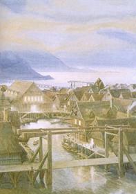 Town
of Men on Long Lake in Wilderland.
Lake-town was built on the surface of the lake supported by great wooden
piles in the water. It was located on the west side of the lake near the
mouth of the
Forest River in a calm
bay that was formed by the shelter of a rock promontory. The town was connected
to the land by a long bridge.
Town
of Men on Long Lake in Wilderland.
Lake-town was built on the surface of the lake supported by great wooden
piles in the water. It was located on the west side of the lake near the
mouth of the
Forest River in a calm
bay that was formed by the shelter of a rock promontory. The town was connected
to the land by a long bridge.
The buildings of Lake-town were made of wood. The greatest houses were around the market-place, which was a round pool with steps and ladders leading down into the lake. The town-hall where the Master of Lake-town presided appears to have been located there as well. The Master was an elected official usually chosen from among the old and wise.
Originally Lake-town was a large, wealthy, and powerful town but over time the town became smaller and old piles could be seen in the water where buildings had once stood. But even after the arrival of Smaug the Dragon in 2770 of the Third Age, Men remained in Lake-town and they traded with the Elves of Mirkwood using the Forest River to transport goods.
Bilbo Baggins helped Thorin Oakenshield and and the Dwarves escape from the Halls of the Elvenkingby using empty barrels that were being sent down the river to Lake-town. They arrived on the shore near Lake-town on September 22, 2941, and approached the guards at the bridge. They crossed over to the town and in a great hall on the market-place they met the Master of Lake-town and Thorin announced that the King under the Mountain had returned.
The Dwarves' arrival caused much excitement in Lake-town. The people hoped that prosperity would return when the Dwarves took up residence in the Lonely Mountain once more. They gave the Dwarves a large house to stay in and fed and clothed them generously. When the Dwarves set out for the mountain, the Lake-men provided them with boats and ponies and provisions.
Some time afterwards, Smaug emerged from the Lonely Mountain and descended on Lake-town. The dragon was first noticed by Bard, whose ancestors had escaped to Lake-town when Smaug destroyed Dale. Now Smaug was intent on destroying Lake-town, for he thought Bilbo the Burglar - who had called himself Barrel-rider - had come from there.
Bard sounded the alarm and the Lake-men cut the bridges and filled water vessels and armed themselves. Smaug set fire to the wooden buildings and smashed the roof of the Great House with his tail. People escaped by boat or by jumping into the lake. Then a thrush appeared and told Bard of a weak spot on the dragon's underbelly, and Bard slew Smaug with his Black Arrow. Smaug landed directly on Lake-town and it was completely destroyed.
After the Battle of the Five Armies, Bard gave part of his share of the dragon hoard to the Master of Lake-town, but the Master was a greedy man and he ran off with the gold and died in the Waste. The new Master was wiser and more honorable. Lake-town was rebuilt north of the original site where the Dragon's bones lay. The town became prosperous again as goods and wealth flowed from the Lonely Mountain and Dale once more. By the time of the War of the Ring, the realm of Dale ruled by Bard's grandson Brand extended far south and east of Lake-town.
Names &
Etymology:
Lake-town was also called Esgaroth.
Esgar means "reed-bed" and Esgaroth is translated as "Reedlake" because there were reed-banks in the western part of the lake.
Sources:
The Hobbit:
"Barrels out of Bond," p. 189, 199; "A Warm Welcome," passim; "Inside Information,"
p. 241; "Fire and Water," passim; "The Return Journey," p. 304; "The Last
Stage," p. 317
The Fellowship
of the Ring: "Many Meetings," p. 241
The History
of Middle-earth, vol. V, The Lost Road and Other Writings: "The Etymologies,"
entry for ESEK
All entries are Copyright © by the Thain from former tuckborough.net. Please contact me if you are Thain or know anything about how to contact the original author.
2003-2011, The Thain's Book - thainsbook.minastirith.cz
- e-mail: thain at tuckborough.net