
An encyclopedia of Middle-earth and Numenor
|
|
|
|
|
|
|
|
|
|
|
|
|
|
| |
|
|
An encyclopedia of Middle-earth and Numenor |
|

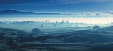
Barrow-downs |
The
Barrow-downs by Anke-Katrin
Eissmann
|
 Downs
east of the Old Forest in Eriador.
They were known as the Barrow-downs because of the barrows, or burial mounds,
that had been made there.
Downs
east of the Old Forest in Eriador.
They were known as the Barrow-downs because of the barrows, or burial mounds,
that had been made there.
The first burial mounds on the Barrow-downs were said to have been built in the First Age by the forefathers of the Edain before they migrated to Beleriand. In the Third Age, the Dunedain, who revered the downs as a resting place of their ancestors, buried many of their lords and kings there. When the northern realm of Cardolan was defeated by the forces of Angmar in 1409, some of the Dunedain took refuge in the Barrow-downs and in the Old Forest beyond. Some of their slain, including the last prince of Cardolan, were buried in mounds on the downs.
When the Great Plague swept north in 1636, many of the people of Cardolan perished and the Barrow-downs were abandoned. The Witch-king then sent evil spirits from Angmar and Rhudaur to the Barrow-downs to enter the barrows. These evil spirits were known as Barrow-wights. The Barrow-downs became a place of fear and even Hobbits had heard of their sinister reputation.
The hills of the Barrow-downs were covered with short, springy grass. Many of the hills had mounds upon them and some had standing stones that stood out of the ground like jagged teeth.
On September 23, 3018, the Witch-king came to the Barrow-downs to rouse Barrow-wights to watch for trespassers on their land. The Witch-king stayed in the Barrow-downs until September 27.
Frodo Baggins and his companions entered the Barrow-downs on September 28 after leaving the house of Tom Bombadil. Tom advised the Hobbits to pass the barrows on the west side. They hoped to make it across the downs to the Great East Road by nightfall, but they fell asleep while resting on a hill and a fog rolled in that caused them to become disoriented.
Frodo became separated from his companions and was taken into a barrow by a Barrow-wight. His friends were lying cold and unconscious on the ground with a sword across their necks. Frodo was able to resist the temptation to put on the Ring and struck out at the Barrow-wight as it reached for his friends. Frodo called for Tom Bombadil, who came to their rescue. Tom sang a song to banish the Barrow-wight, and it fled with a shriek.
Tom gave the Hobbits swords of Westernesse from the barrow that had been used to fight the Witch-king long ago. He spread out the gold and treasures from the barrow on the grass so that the barrow's spell was broken and no Wight would return to it. For Goldberry, Tom took a brooch set with blue stones that had belonged to a fair lady who died long ago. He then escorted the Hobbits to the Great East Road on the edge of the Barrow-downs.
Names &
Etymology:
Called Tyrn Gorthad in Sindarin.
The exact translation of Tyrn Gorthad is uncertain. The word tyrn
may mean "downs" or "hills." The word gorth may mean "one who is
dead." The ending ad is used for "place." Thus gorthad might
mean "tombs" and Tyrn Gorthad could be translated as "Hills of Tombs"
or "Barrow Downs."
Also called the Great Barrows and the Downlands.
Sources:
The Fellowship
of the Ring: "In the House of Tom Bombadil," p. 141, 145; "Fog on the
Barrow-downs," passim; "Strider," p. 176
Appendix
A of The Lord of the Rings: "The North-kingdom and the Dunedain," p.
320-21
Gateway
to Sindarin by David Salo: p. 259, 393
When the North-kingdom of Arnor was founded in 3320 of the Second Age, the Ettenmoors were on the northern border of the region called Rhudaur. In 1300 of the Third Age, the Lord of the Nazgul established the realm of Angmar north of the Ettenmoors. After the Lord of the Nazgul was defeated at the Battle of Fornost in 1975, he rode off into the Ettenmoors and then vanished from the north.
In 2930, Arador, the Chieftain of the Dunedain, was captured and slain by Trolls in the Coldfells north of Rivendell. It is likely that the Coldfells were the same as - or possibly a part of - the Ettenmoors. Arador was the grandfather of Aragorn, King Elessar.
In October of 3018, Gandalf rode into the Ettenmoors after battling the Nazgul at Weathertop. He hoped to lead the Nazgul away from Frodo the Ring-bearer, and four of them pursued him for a while. Gandalf had to part with Shadowfax in the Ettenmoors because the ground was too rocky for a horse.
Names &
Etymology:
The element etten is from
the Old English eoten meaning "troll, ogre." A moor is a
high, barren land, and dales are valleys. The Ettenmoors were also
called the Troll-fells. The word fells is synonymous with
moors.
Coldfells
was probably also another name for the Ettenmoors, though it may have been
the name of an area in or near the Ettenmoors.
Sources:
The Fellowship
of the Ring: "Flight to the Ford," p. 212, 215; "The Council of Elrond,"
p. 278; "The Ring Goes South," p. 287
Appendix
A of The Lord of the Rings: "The North-kingdom and the Dunedain," p.
320; "The Tale of Aragorn and Arwen," p. 338
Appendix
B of The Lord of the Rings: "The Tale of Years," p. 367
"Nomenclature
of The Lord of the Rings," entry for Ettendales
The Lord
of the Rings: A Reader's Companion by Wayne G. Hammond and Christina
Scull: "Flight to the Ford," p. 183, 188
Note:
In the "Prologue"
of the early Ballantine paperback edition of
The
Fellowship of the Ring, the Far Downs are called the
Fox
Downs. This appears to be a typographical error.
Sources:
The Fellowship
of the Ring: "Prologue: Concerning Hobbits," p. 14"
Appendix
B of The Lord of the Rings: "The Tale of Years," p. 378
Men lived in the North Downs long before the founding of the North-kingdom of Arnor and continued to do so afterwards. In 861 of the Third Age, Fornost became the capital of the North-kingdom.
King Araphor defended the North Downs and Fornost against an attack by the Witch-king of Angmar in 1409. During another attack by the Witch-king in 1974, Fornost was captured but King Arvedui held out on the North Downs for a time before being forced to retreat. The next year, the Witch-king was defeated at the Battle of Fornost, which was fought on the plain between the North Downs and Lake Evendim to the west. The North Downs and Fornost were deserted for a long time afterwards, but people came to live there again in the Fourth Age.
Sources:
Map of Middle-earth
by Christopher Tolkien
The Fellowship
of the Ring: "The Council of Elrond," p. 257
The Return
of the King: "Homeward Bound," p. 272-73
Appendix
A of The Lord of the Rings: "The North-kingdom and the Dunedain," p.
321; "Gondor and the Heirs of Anarion," p. 331
Unfinished
Tales: "Aldarion and Erendis," p. 214 note 3
Sam Gamgee's cousin Halfast Gamgee claimed to have seen a Tree-man walking on the North Moors. Whether this Tree-man was a wayward Ent or Entwife, a Giant, some other creature, or a figment of Hal's imagination is unknown.
Sources:
The Fellowship
of the Ring: "The Shadow of the Past," p. 53-54; "The Ring Goes South,"
p. 301
The Lord
of the Rings: A Reader's Companion by Wayne G. Hammond and Christina
Scull: "The Shadow of the Past," p. 77
Atlas of
Middle-earth by Karen Wynn Fonstad: Shire map, p. 70-71
Source:
Map of Middle-earth
by Christopher Tolkien
Unfinished
Tales: "The Hunt for the Ring," p. 348
Sources:
The Fellowship
of the Ring: "Prologue: Concerning Hobbits," p. 15; "Prologue: Of the
Ordering of the Shire," p. 19; "At the Sign of the Prancing Pony," p. 168
Atlas of
Middle-earth by Karen Wynn Fonstad: Map of the Shire, p. 70-71
Amon Hen |
The
slopes of Amon Hen in the New Line
film
|
 The
Hill of Sight. Amon Hen was on the western bank of Nen
Hithoel, near the southern end of the lake. Amon Lhaw,
the Hill of Hearing, stood across the lake from Amon Hen. The hills were
part of the range called the Emyn Muil. Amon Hen
was a little more than 1,000 feet high.
The
Hill of Sight. Amon Hen was on the western bank of Nen
Hithoel, near the southern end of the lake. Amon Lhaw,
the Hill of Hearing, stood across the lake from Amon Hen. The hills were
part of the range called the Emyn Muil. Amon Hen
was a little more than 1,000 feet high.
At the foot of Amon Hen on the shore of Nen Hithoel there was a wide green lawn called Parth Galen. Water flowed down to the lawn from a spring on the hill.
There were woods on the slopes of Amon Hen. The lower slopes were gentle but became gradually steeper. A path led up the eastern side of Amon Hen with stairs in some of the steeper places. Partway up the hill was a small grassy place looking out over the lake. Rowan trees grew around the edge and there was a wide flat stone in the middle.
At the top of Amon Hen was the Seat of Seeing. This was a great chair upon four pillars that stood at the center of a circle paved with stones which was surrounded by a battlement. From the Seat of Seeing one might see far across the land. The Seat of Seeing and the Seat of Hearing on Amon Lhaw were built by the Men of Gondor, probably around the end of the Second Age.
The Fellowship came to Parth Galen at the foot of Amon Hen on February 25, 3019 of the Third Age, and camped there. The next day on February 26, Frodo Baggins climbed the slopes of Amon Hen and stopped at the grassy place partway up the hill. He was surprised by Boromir, who tried to convince Frodo to give him the Ring. Frodo fled to the top of Amon Hen, where he sat on the Seat of Seeing and saw war brewing throughout Middle-earth and the Eye of Sauron seeking him. Frodo made the decision to set out for Mordor alone and returned down the slopes of Amon Hen.
A company of Uruk-hai from Isengard led by Ugluk came to Amon Hen that same day seeking the Ring-bearer. They were joined by Grishnakh and a company of Orcs from Mordor who had crossed the Anduin. They mistakenly seized Merry Brandybuck and Pippin Took. Boromir tried to come to their rescue, but he was slain near the foot of Amon Hen. Aragorn, Legolas and Gimli went after Merry and Pippin, while Frodo and Sam headed to Mordor, and thus the Fellowship was broken.
Names &
Etymology:
Also called the Hill of Sight
and the Hill of the Eye. The word amon means "hill" and the
word hên means "eye."
Sources:
The Fellowship
of the Ring: "The Great River," p. 406, 410; "The Breaking of the Fellowship,"
passim
The Two
Towers: "The Departure of Boromir," p. 15, 20; "The Black Gate Is Closed,"
p. 247, 252
The History
of Middle-earth, vol. V, The Lost Road and Other Writings: "The Etymologies,"
entries for AM2 and KHEN-D-E
The Lord
of the Rings: A Reader's Companion by Wayne G. Hammond and Christina
Scull: "The Breaking of the Fellowship," p. 350
Amon Lhaw |
Map
of Amon Lhaw
|
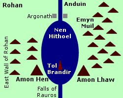 The
Hill of Hearing. Amon Lhaw was located on the eastern shore of Nen
Hithoel, a lake on the Anduin. Amon
Hen, the Hill of Sight, stood on the western shore opposite Amon Lhaw.
In the lake between the two hills was the island of Tol
Brandir. Amon Lhaw was part of the range of hills called the Emyn
Muil.
The
Hill of Hearing. Amon Lhaw was located on the eastern shore of Nen
Hithoel, a lake on the Anduin. Amon
Hen, the Hill of Sight, stood on the western shore opposite Amon Lhaw.
In the lake between the two hills was the island of Tol
Brandir. Amon Lhaw was part of the range of hills called the Emyn
Muil.
In the early days of Gondor, watch posts were maintained on Amon Lhaw and Amon Hen and high seats were built on the summits of the two hills. From the Seat of Seeing on Amon Hen, a person might see for a great distance. Although the Seat of Hearing is not described, it seems likely that from it a person could hear things from far away.
When Frodo Baggins and Sam Gamgee set out alone for Mordor on February 26, 3019 of the Third Age, they rowed across Nen Hithoel and came ashore on the southern slopes of Amon Lhaw.
Names &
Etymology:
Also called the Hill of Hearing.
Amon Lhaw means "Hill of Hearing" from amon meaning "hill" and
lhaw
meaning "ears."
Sources:
The Fellowship
of the Ring: "The Great River," p. 410; "The Breaking of the Fellowship,"
p. 411, 417-18, 423
The History
of Middle-earth, vol. V, The Lost Road and Other Writings: "The Etymologies,"
entries for AM2 and LAS2
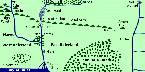
At the western end of Andram, the Narog passed through a deep gorge with rapids but no waterfall. The underground stronghold of Nargothrond was in the steep western bank of the Narog. The wooded highlands called the High Faroth surrounded Nargothrond on the west side of the Narog. Opposite Nargothrond on the east bank stood Amon Ethir, a hill built by Finrod Felagund as a guardpost for his realm.
Seventy-five miles east of Nargothrond, the great river Sirion passed under Andram. On the plain above Andram, the Sirion slowed to form Aelin-uial, the Meres of Twilight, and then cascaded over the Falls of Sirion. The waters of the Sirion bored a nine-mile tunnel beneath Andram and issued from the southern side of the hills through an archway called the Gates of Sirion. The Sirion then continued on its course to the Bay of Balar.
At its eastern end, Andram became less sheer. The last hill on the eastern end was Ramdal, the Wall's End. Beyond Ramdal stood a solitary hill called Amon Ereb. During the First Battle in 1497 of the Years of the Trees, Denethor was surrounded and slain by Morgoth's forces on Amon Ereb.
Map of Andram:
Names &
Etymology:
The name Andram means "Long
Wall" in Sindarin from and meaning "long" and ram meaning
"wall."
Sources:
The Silmarillion:
"Of the Sindar," p. 96; "Of Beleriand and Its Realms," p. 122-23; "Appendix
- Elements in Quenya and Sindarin Names," entries for an(d) and
ram
Beacon-hills of Gondor |
Top:
Lighting the Beacons in the New
Line film
Bottom: Map of the Beacon-hills |
The system of seven Beacon-hills was established after Rohan was founded in 2510 of the Third Age as a means of communication between the allied realms of Rohan and Gondor. The Beacon-hill system could be used both ways: Gondor could signal Rohan, and Rohan could signal Gondor - though the latter was rarely done. Beacons of wood and fuel were maintained upon each hill by the Beacon-wardens.
During the War of the Ring, Denethor, the Steward of Gondor, decided to light the beacons, probably after learning of the fleet of Corsairs preparing to attack Minas Tirith from the south. On the night of March 7-8, 3019, all seven of the Beacon-hills of Gondor were set ablaze.
Gandalf
and Pippin Took saw the lighting of the Beacon-hills
as they rode toward Minas Tirith. When the Rohirrim later rode past the
Beacon-hills on the way to Minas Tirith, the fires had been quenched.
The first of the seven Beacon-hills of Gondor. Amon Din was the closest of the Beacon-hills to Minas Tirith. It was located near the eastern end of the Druadan Forest. Amon Din was a rocky, barren hill that stood out from the trees. Birds and animals were rarely found on Amon Din and Men used it only as an outpost.
Amon Din was the first hill to have a beacon built on its summit. Its original purpose was to alert Minas Tirith to the approach of enemy forces. From Amon Din, sentries could keep watch over the crossing of the Anduin near Cair Andros and the passage into Ithilien from Dagorlad.
Names &
Etymology:
Amon Dîn means "Silent
Hill" from amon meaning "hill" and dîn meaning "silent."
It may have been so named because it was isolated and uninhabited.
The second of the seven Beacon-hills of Gondor. Eilenach was located in the middle of the Druadan Forest. There were pine trees around its base. Eilenach could be seen from a great distance. It was the highest point in the forest, and was the second tallest of the Beacon-hills after Halifirien. The summit of Eilenach was sharp and narrow, and there was not much room for a large beacon.
Eilenach was one of the three oldest Beacon-hills, along with Amon Din and Min-Rimmon. It was originally used mainly for communicating with the people of Anorien - a region of Gondor west of Minas Tirith.
King Theoden and the Riders of Rohan camped at the foot of Eilenach on the night of March 13-14, 3019 of the Third Age, on their way to Minas Tirith.
Names &
Etymology:
The name Eilenach is of unknown
origin. It is not Sindarin, Numenorean, or Common Speech. The hill was
probably named before the coming of the Numenoreans
to Middle-earth.
The third of the seven Beacon-hills of Gondor. Nardol was located at the western edge of the Druadan Forest. It was at the end of a high ridge extending from the White Mountains. The ridge was once covered with trees but it had been stripped bare by the workers in the nearby quarries.
Nardol had an especially large beacon-fire. A guard was maintained on Nardol to protect both the beacon and the quarries, and a large store of fuel was kept ready.
On a clear night, Nardol's beacon could be seen from as far away as Halifirien, the seventh and last Beacon-hill, which stood in the Firien Wood on the border between Gondor and Rohan. Erelas, Min-rimmon, and Calenhad curved slightly southward and were not in the straight line of sight between Nardol and Halifirien.
Names &
Etymology:
Nardol means "Fire-hilltop"
or "Fiery head." The word nar means "fire." The word dol means
"head" and is often used to mean "hill." Nardol was named for its large
beacon.
The fourth of the Beacon-hills of Gondor. Erelas was a green hill without trees. It was located west of the Druadan Forest at the foot of the White Mountains, somewhat south of Nardol. Erelas was a small hill. Its beacon was not always necessary and was only lit in times of great urgency, like during the War of the Ring.
Names &
Etymology:
The name Erelas is Sindarin
in form but its meaning is unclear. Apparently the elements er meaning
"single" and las meaning "leaf" are not part of this name.
("Rivers
and Beacon-hills of Gondor," p. 19)
The fifth of the Beacon-hills of Gondor. Min-Rimmon was located at the foot of the White Mountains. It was one of the three oldest beacons along with Amon Din and Eilenach. Before the founding of Rohan, the beacon on Min-Rimmon was used to communicate with the people of Anorien - the province of Gondor west of Minas Tirith.
King Theoden and the Riders of Rohan camped at the foot of Min-Rimmon on the way to Minas Tirith on March 12, 3019 of the Third Age.
Names &
Etymology:
The name Min-Rimmon means
"Peak of the Rimmon." The word min means "peak" in Sindarin from
mini meaning "stick out." The word Rimmon is probably of pre-Numenorean
origin. It either means "group of crags" or was the name of the group of
crags of which Min-Rimmon was a part. (UT, p.
453)
The sixth of the Beacon-hills of Gondor. Calenhad had a flat crown covered with green turf. It was a relatively small beacon, though it was taller than Erelas. Like Erelas, the beacon of Calenhad was lit only in times of great need, as in the War of the Ring.
Names &
Etymology:
The name Calenhad means "green
space" in reference to its flat, grassy top. The word calen means
"green" and had is from sad meaning "place, spot."
The seventh of the Beacon-hills of Gondor. Halifirien was located in the Firien Wood on the border between Gondor and Rohan. It was the tallest of the Beacon-hills and its summit rose high above the treetops.
Halifirien was located in the southeastern corner of the forest. Behind it was the deep cleft called the Firien-dale. The Mering Stream flowed past the western side of the hill.
The slopes of Halifirien were wooded nearly to the summit. The trees were especially dense on the lower slopes, particularly near the Mering Stream. The southern slope of Halifirien which rose out of the Firien-dale was sheer, but the other slopes were long and gradual.
A path marked by standing stones ran from the Great West Road to Halifirien. An ancient stone stairway ascended the hill to the top. The summit was surrounded by a belt of white birches. At the summit was a wide level circle where the beacon was located. There were temporary lodges for the Beacon-wardens near the summit.
At the beginning of the Third Age, after the death of Elendil in the War of the Last Alliance, Isildur brought his father's remains to the hill to be buried. He chose the location because it was then near the center of Gondor. Elendil's tomb was on the eastern side of the circle at the summit of the hill. It was marked by a black stone bearing the letters lambe, ando, lambe for Elendil's name. The tomb was covered with white flowers called alfirin or simbelmyne. The summit of the hill remained green and untouched even as the path to the hill became overgrown.
The hill became a sacred place and it was called Amon Anwar, the Hill of Awe. Its original name had been Eilenaer. No one was allowed to ascend to the top of the hill except the King of Gondor and any who accompanied him. It became customary for the King to bring his heir to the hill when he came of age to tell him of Elendil's tomb and of other important matters of the realm. This custom was later followed by the Stewards of Gondor.
In 2510, Cirion, the Steward of Gondor, brought Eorl the Young to the Hill of Awe. Eorl and his people had helped Gondor fight the Balchoth in the Battle of the Field of Celebrant. Cirion gave Eorl the province of Calenardhon, which became Rohan. In return, Eorl swore an Oath to help Gondor in time of need. Elendil's remains were removed from the hill and were interred in the Hallows of Minas Tirith.
The Mering Stream became the border between Rohan and Gondor. Technically, the hill was east of the border and was in Gondor. Initially, guard and maintenance of the hill was shared by both realms. However, over time the entire Firien Wood including the hill came to be considered the territory of Rohan.
The Rohirrim named the hill Halifirien, the Holy Mountain. They considered the hill to be a sacred place because it was where Eorl had taken his Oath and had been granted the land of Rohan.
When the system of Beacon-hills was established as a means of communicating between Gondor and Rohan, a great beacon was placed on Halifirien. This was the beacon that was visible to the people of Rohan.
After the War of the Ring, Aragorn, King Elessar of Gondor brought King Eomer of Rohan to Halifirien and they renewed the Gift of Cirion and the Oath of Eorl.
Names &
Etymology:
The name Halifirien means
"holy mountain" in the language of the Rohirrim. It is from the Anglo-Saxon
hálig-firgen
where hálig means "holy" and firgen means "mountain."
The Sindarin name was Amon Anwar, meaning "the Hill of Awe" from amon meaning "hill" and anwar meaning "awe." It was so named because the tomb of Elendil was on its summit.
Before the burial of Elendil, the hill was called Eilenaer. This was a pre-Numenorean name related to Eilenach. The meaning is not known.
![]()
Movie Note:
In the film version of The
Lord of the Rings, the signal beacon in Minas Tirith was lit
by Pippin Took contrary to Denethor's orders.
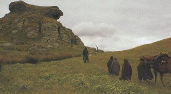
The village of Bree was on the western slopes of Bree-hill. A deep dike and a hedge formed a semi-circular fence enclosing the village against the hill. There were about 100 stone houses on the lower part of hillside where Men lived, while Hobbits lived farther up the slopes of the hill. The Prancing Pony was at the foot of Bree-hill, and the inn had two wings that cut into the slope of the hill.
The village of Staddle was on the gentle southeastern slope of Bree-hill. Combe was in a deep valley east of Bree-hill while Archet was in the eaves of the Chetwood. For a few miles around Bree-hill there were fields and tamed woodland.
Names &
Etymology:
Also written as Bree Hill.
Sources:
The Fellowship
of the Ring: "Fog on the Barrow-downs," p. 159-60; "At the Sign of
the Prancing Pony," p. 161-62, 164; "Strider," p. 187; "A Knife in the
Dark," p. 193
The Return
of the King: "Homeward Bound," p. 268
Sources:
The Fellowship
of the Ring: "A Conspiracy Unmasked," p. 108, 110
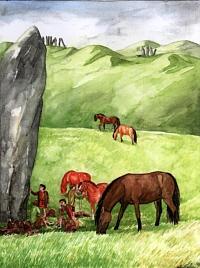
Cerin Amroth |
Cerin
Amroth by Alan Lee
|
 Hill
in Lothlorien. The slopes of Cerin Amroth
were grassy and covered with flowers - the golden elanor
and the pale niphredil. On the summit
of the hill were two circles of trees; the outer trees had white bark and
the inner trees were the gold-leaved mallorn.
Hill
in Lothlorien. The slopes of Cerin Amroth
were grassy and covered with flowers - the golden elanor
and the pale niphredil. On the summit
of the hill were two circles of trees; the outer trees had white bark and
the inner trees were the gold-leaved mallorn.
Cerin Amroth was the site of the house that King Amroth of Lothlorien built on a flet high in the branches of the trees. The flet on Cerin Amroth was originally the highest in Lothlorien and was used to keep watch on Dol Guldur across the Anduin.
At the time of the Fellowship's arrival in Lothlorien in January 3019 of the Third Age, King Amroth's house was gone but there was a white flet in a tall tree on the summit of Cerin Amroth. Frodo and Sam climbed up to the flet with Haldir. Frodo felt as if he had entered a timeless land, while Sam said, "I feel as if I was inside a song." (FotR, p. 365)
Aragorn called Cerin Amroth "the heart of Elvendom on earth." (FotR, p. 367) He stood at the foot of the hill recalling the Midsummer's Eve in 2980 when he and Arwen became betrothed on Cerin Amroth. After the Fellowship departed, Aragorn never went to Cerin Amroth again. After he died in the year 120 of the Fourth Age, Arwen went to Cerin Amroth to die.
Names &
Etymology:
Cerin means "circular enclosure."
King Amroth's name may have meant "upclimber, high climber" probably as
a reference to the flet he built on Cerin Amroth.
Sources:
The Fellowship
of the Ring: "Lothlorien," p. 353-55, 364-67
Unfinished
Tales: "The History of Galadriel and Celeborn and of Amroth King of
Lorien," p. 240-48
The History
of Middle-earth, vol. V, The Lost Road and Other Writings: "The Etymologies,"
KOR
entry
Pippin was unable to sleep. He could not stop thinking about the palantir that he had picked up when Grima threw it from Orthanc. Pippin took the palantir from Gandalf while the Wizard slept and looked into it. The Hobbit was confronted by Sauron who demanded to know who he was. Moments later a Nazgul flew overhead. Gandalf took Pippin and rode with all speed to Minas Tirith while the rest of the company broke came and proceeded towards Helm's Deep.
Names &
Etymology:
In Sindarin, dol means "head"
often used to mean "hill." The word baran means "golden-brown" and
the hill's name has been translated as "gold-brown hill." But other notes
left by Tolkien indicate that in this case baran could be a lenited
form of paran meaning "smooth, shaven" often applied to hills without
trees.
Source:
The Two
Towers: "The Palantir," p. 194-95 and passim
Appendix
F of The Lord of the Rings: p. 416
Unfinished
Tales: Index entry for Dol Baran
The Silmarillion:
"Appendix - Elements in Quenya and Sindarin Names," entry for dol
The Lord
of the Rings: A Reader's Companion by Wayne G. Hammond and Christina
Scull: "The Palantir," p. 433
In the 1600s of the Third Age, Hurin of Emyn Arnen was the Steward of King Minardil of Gondor, as well as his successors King Telemnar and King Tarondor. Hurin was a Man of Numenorean blood and all the Stewards of Gondor after him were his descendants.
Faramir, the Steward of Gondor after the War of the Ring, was made Prince of Ithilien and Lord of Emyn Arnen by Aragorn, King Elessar, in 3019. He made his home in Emyn Arnen with his wife Eowyn and their son Elboron. A white house was built for them there and the gardens, designed by Legolas, were renowned. Beregond became the Captain of Faramir's Guard, the White Company, and he went to dwell in Emyn Arnen as well.
Names &
Etymology:
Emyn Arnen means "hills beside
the waters," referring to their location on the Anduin. The word emyn
is Sindarin for "hills." The word arnen is Quenya, composed of ar
meaning
"outside, beside" and nen meaning "waters." Arnen was an
old name for a large part of Ithilien and the hills were later named "the
hills of Arnen."
Sources:
The Return
of the King: "Minas Tirith," p. 22; "The Steward and the King," p.
247
Appendix
A of The Lord of the Rings: "The Realms in Exile," p. 319; "The Stewards,"
p. 333
The History
of Middle-earth, vol. V, The Lost Road and Other Writings: "The Etymologies,"
entries for AM2, AR2, and NEN
The History
of Middle-earth, vol. IX, Sauron Defeated: "The Epilogue," p. 123
The History
of Middle-earth, vol. XII, The Peoples of Middle-earth: "The Heirs
of Elendil - The Stewards of Gondor," p. 220
"The Rivers
and Beacon-hills of Gondor," by J.R.R. Tolkien, edited by Carl F. Hostetter,
commentary by Christopher Tolkien, in Vinyar Tengwar #42, July 2001,
p. 17
Emyn Muil |
The
Emyn Muil in the New Line film
|
 Rugged
hills along the Anduin. The Emyn Muil
were located on both sides of the river around Nen
Hithoel north of the
Falls of Rauros.
The landscape was bleak and the terrain was difficult and treacherous.
Rugged
hills along the Anduin. The Emyn Muil
were located on both sides of the river around Nen
Hithoel north of the
Falls of Rauros.
The landscape was bleak and the terrain was difficult and treacherous.
On the west side of the river, the Emyn Muil formed two long ridges that ran north to south. The western sides of the ridges were steep, while the eastern sides sloped more gently but were intercut with ravines and gullies. There was a deep, winding valley between the two ridges with a stream running through it. The ridge nearest the Anduin was the taller of the two. The other ridge descended about 20 fathoms to a wide shelf which ended in a sheer cliff that was the western edge of the Emyn Muil. This cliff was called the East Wall of Rohan because it formed part of the eastern border of that country.
On the east side of the river, the hills of the Emyn Muil extended farther and were more irregular. The terrain was like a labyrinth of twisted rock through which there was no straight passage. The southeastern face of the Emyn Muil was a high, sheer cliff overlooking the plains below. The cliff was lower at its northern end, but it was still about 18 fathoms (108 feet) high. At the foot of the cliff was a gulley that ran north to south. In this gulley was one of the many small rivers that flowed down from the Emyn Muil into the marshlands below.
Ancient landmarks of Gondor in the Emyn Muil included the Seat of Seeing on Amon Hen on the western shore of Nen Hithoel and the Seat of Hearing on Amon Lhaw on the eastern side. The North Stair was carved into the cliff beside the Falls of Rauros. The Argonath were erected at the northern end of the Emyn Muil on either side of the Anduin to mark the northern boundary of Gondor by Romendacil II probably around the year 1248 of the Third Age.
In the years leading up to the War of the Ring, Orc raiding parties descended from the Emyn Muil into Rohan to steal horses. In 3002, Eomund, the father of Eomer and Eowyn, was killed by one such group of raiders when he pursued them into the Emyn Muil and was ambushed.
On February 26, 3019, a band of Uruk-hai captured the Hobbits Merry Brandybuck and Pippin Took and carried them through the western Emyn Muil toward Isengard. In the valley between the two ridges, an argument among the Orcs about what to do with the prisoners led to the deaths of five of the Northern Orcs. Aragorn, Legolas, and Gimli found the bodies as they pursued the Hobbits and their captors through the Emyn Muil. The Three Hunters reached the East Wall at dawn on February 27 and descended onto the plains of Rohan.
Frodo Baggins and Sam Gamgee had a more difficult journey through the eastern Emyn Muil. They wandered through the twisted knot of hills for four days seeking a way down until February 29, when they came to the point where the cliff was lower. The Hobbits descended the cliff with the help of the Elven rope that Sam had obtained in Lothlorien. They then came to the river gulley but were unable to cross it.
That night they saw Gollum climbing down the cliff. Sam tried to seize the creature, but Gollum caught him in a strangle-hold. Frodo threatened Gollum with Sting, but in the end he took pity on Gollum and spared his life. After attempting to escape again, Gollum swore to serve Frodo as the Master of the One Ring. He led the Hobbits into the river gulley and out of the Emyn Muil.
Names &
Etymology:
Emyn Muil is translated as
"Drear Hills." The word emyn means "hills." The word muil
means "twilight, shadow, vagueness."
Sources:
The Fellowship
of the Ring: "Farewell to Lorien," p. 389-90; "The Great River," p.
396, 401, 405-6, 408; "The Breaking of the Fellowship," 418, 423
The Two
Towers: "The Riders of Rohan," p. 23-26, 29, 30, 39; "The Uruk-hai,"
p. 47-52; "The White Rider," p. 98, 101, 104; "The King of the Golden Hall,"
p. 110; "Flotsam and Jetsam," p. 169; "The Taming of Smeagol," passim;
"Of Herbs and Stewed Rabbit," p. 258; "The Window on the West," p. 277;
"Shelob's Lair," p. 333
The Return
of the King: "Minas Tirith," p. 31; "The Black Gate Opens," p. 162;
"Mount Doom," p. 221; "The Steward and the King," p. 248
Appendix
A of The Lord of the Rings:
"Gondor and the Heirs of Anarion," p. 326, 329; "The House of Eorl," p.
351
Appendix
B of The Lord of the Rings: "The Tale of Years," p. 373
Unfinished
Tales: Index entry for Emyn Muil (translated as "Drear Hills")
The History
of Middle-earth, vol. V, The Lost Road and Other Writings: "The Etymologies,"
entries for AM2 and MUY
Green Hill Country (The Shire) |
The
Green Hill Country in the New Line
film
|
 Hilly
region in the Shire. The Green Hill Country stretched
from Tuckborough in the Westfarthing
across the north end of the Southfarthing and across much of the Eastfarthing.
The
Great Smials - the ancestral
home of the Tooks - were dug into the hills around Tuckborough. The Stock
Road skirted the northern edge of the Green Hill Country.
Hilly
region in the Shire. The Green Hill Country stretched
from Tuckborough in the Westfarthing
across the north end of the Southfarthing and across much of the Eastfarthing.
The
Great Smials - the ancestral
home of the Tooks - were dug into the hills around Tuckborough. The Stock
Road skirted the northern edge of the Green Hill Country.
On September 23, 3018 of the Third Age - the first day of their journey - Frodo, Sam, and Pippin climbed up into the Green Hill Country. Frodo paused on a hill and looked back at the lights of Hobbiton, saying, "I wonder if I shall ever look down into that valley again." (FotR, p. 80) The Hobbits walked into the night through the hills and camped in a patch of fir trees, where they were seen by a fox. The next day they made their way down the Stock Road to the Woody End.
During the War of the Ring, the Tooks defended the Great Smials and the Green Hills against the Men in the service of Saruman who had taken over the Shire. Many Hobbits from the Green Hills fought in the Battle of Bywater on November 3, 3019.
When Frodo left the Shire for good in 3021, he and Sam camped in the Green Hills on the night of September 21 and met the Last Riding of the Keepers of the Rings in the Woody End the next day.
Sources:
The Fellowship
of the Ring: "Three Is Company," p. 80-81
The Return
of the King: "The Scouring of the Shire," p. 289, 294; "The Grey Havens,"
p. 307
The Journeys
of Frodo by Barbara Strachey: Map #3, "Green Hill Country"
At the time of the War of the Ring, the people of the Green Hills were ruled by Hirluin. Hirluin led a company of 300 men to help defend Minas Tirith, arriving in the City on March 9, 3019 of the Third Age. On March 15, they fought in the Battle of the Pelennor Fields. Hirluin was killed in the battle.
Names &
Etymology:
The Green Hills were called
Pinnath
Gelin in Sindarin. The word pinnath means "ridges" derived from
penn
meaning "slope, declivity" and ath, a collective plural. The word
gelin
is a lenited form of celin which is the plural of calen meaning
"green."
Sources:
The Return
of the King: "Minas Tirith," p. 43; "The Passing of the Grey Company,"
p. 63; "The Battle of the Pelennor Fields," p. 121, 124-25; "The Steward
and the King," p. 243
The Silmarillion:
"Appendix - Elements in Quenya and Sindarin Names," entry for calen
The History
of Middle-earth, vol. V, The Lost Road and Other Writings: "The Etymologies,"
entry for PEN, PENED
Names &
Etymology:
Also called Hobbiton Hill.
Sources:
The Hobbit:
"An Unexpected Party," p. 9-12
The Fellowship
of the Ring: "A Long-Expected Party," p. 30
Appendix
D of The Lord of the Rings: p. 390
The seven-tiered city of Minas Anor - later Minas Tirith - was built on the hill shortly after the founding of Gondor in 3320 of the Second Age. The Hallows where the Kings and Stewards were laid to rest were located on the rocky spur, which was on a level with the fifth tier of the City.
There was another spur on the front or eastern side of the Hill of Guard which bisected the second through sixth levels of the City. The road that wound around the City passed through archways in this spur. On the top or seventh level, the spur formed a battlement where people could look out over the Pelennor Fields and beyond.
Names &
Etymology:
The Sindarin name of the Hill
of Guard was Amon Tirith from amon meaning "hill" and
tirith
meaning "watch, guard." It was so named because Minas Tirith was located
there. The name of the City was not changed from Minas Anor to Minas
Tirith until 2043 of the Third Age, but whether the hill was previously
called Amon Anor - the Hill of the Sun - is not known.
Sources:
The Return
of the King: "Minas Tirith," p. 23-24
"Nomenclature
of The Lord of the Rings," entry for Hill of Guard
Lake Evendim was on the eastern side of the Hills of Evendim. The lake was the source of the Brandywine. Another, unnamed river began on the western side of the Hills of Evendim and flowed into the Lune. The city of Annumimas was in the southern hills on the shore of Lake Evendim.
Annuminas was the capital of the North-kingdom of Arnor until 861 of the Third Age when the capital was moved eastward to Fornost in the North Downs. Annuminas was abandoned and fell into ruin.
The Witch-king of Angmar captured Fornost in 1974. In 1975, an army of Elves and Men of Arnor and Gondor gathered in the Hills of Evendim and then came down onto the plain between the Hills of Evendim and the North Downs and defeated the Witch-king in the Battle of Fornost.
Aragorn, King Elessar, rebuilt Annuminas in the Fourth Age and it became the capital of Arnor once more.
Names &
Etymology:
The Hills of Evendim were calledEmyn
Uial in Sindarin. The word emyn means "hills" and uial
means 'twilight."
Evendim means "evening twilight."
Sources:
The Fellowship
of the Ring: "The Council of Elrond," p. 257
Appendix
A of The Lord of the Rings: "The North-kingdom and the Dunedain," p.
324; "Gondor and the Heirs of Anarion," p. 331
The Silmarillion:
"Appendix - Elements in Quenya and Sindarin Names," entries for amon
and uial
During the War of the Ring, stores of food, beer, and goods were kept in the old quarries by the Chief's Men, and after the Scouring of the Shire these goods were used by the Hobbits to celebrate the Yule holiday. The Brockenbores in the Hills of Scary were also the hiding place of a band of rebel Hobbits led by Fatty Bolger during the war.
Names &
Etymology:
Scar is an English dialectical
word meaning "rocky cliff."
Sources:
The Fellowship
of the Ring: Map of "A Part of the Shire"
The Return
of the King: "The Grey Havens," p. 301-302
"Nomenclature
of The Lord of the Rings," entry for Scary
Himring |
Map
of Himring
|
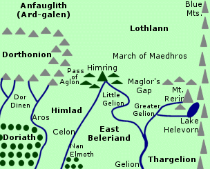 Hill
in East Beleriand where Maedhros had his stronghold.
Himring was part of a small range of hills between Dorthonion and the Blue
Mountains. It was a large hill with no trees and a flat summit where
Maedhros built a citadel. The climate on Himring was cold and a bitter
north wind blew constantly through the Pass of Aglon on its western side.
Hill
in East Beleriand where Maedhros had his stronghold.
Himring was part of a small range of hills between Dorthonion and the Blue
Mountains. It was a large hill with no trees and a flat summit where
Maedhros built a citadel. The climate on Himring was cold and a bitter
north wind blew constantly through the Pass of Aglon on its western side.
The Pass of Aglon divided Himring from Dorthonion. To the east was a wider passage called Maglor's Gap between Himring and the Blue Mountains. East Beleriand was vulnerable to attack from Morgoth's lands in the north at these points, and Himring was an important part of the line of defense.
The guarded land north of Himring and Maglor's Gap was called the March of Maedhros. Riders patrolled the plain of Lothlann bordering Ard-galen, which later became Anfauglith, the Gasping Dust.
South of Himring was the plain called Himlad where Maedhros' brothers Celegorm and Curufin lived. Himlad was bordered on the east by the River Celon which sprang from the Hill of Himring.
The Little Gelion also flowed from Himring and joined the Greater Gelion to form the Gelion. Maedhros' brother Maglor inhabited the land between the two tributaries directly south of the Gap that bore his name. Maedhros' brother Caranthir had a stronghold on Mount Rerir in the Blue Mountains east of the Gap.
After the death of his father Feanor following the Battle-under-Stars, Maedhros refused the High Kingship of the Noldor, which passed instead to his uncle Fingolfin. Maedhros felt remorse for his father's decision to abandon Fingolfin and many of his kin when there were not enough ships to carry all the Noldor to Middle-earth, forcing those left behind to cross the Grinding Ice.
Although Maedhros had made amends with Fingolfin, he decided that he and his brothers should settle in East Beleriand to put some distance between them and the other Noldor. Maedhros also realized the importance of guarding the Gap between Dorthonion and the Blue Mountains against an invasion. He established his stronghold on the Hill of Himring around the year 7 of the First Age.
In the year 60, an army of Orcs attacked Dorthonion and tried to invade Beleriand through the Pass of Sirion in the west and Maglor's Gap in the east. But Maedhros and Fingolfin were prepared and they defeated the Orcs in the Glorious Battle. Afterwards the watch on Maglor's Gap was increased, including a force of cavalry.
During the Battle of Sudden Flame in 455, the eastern marches were again under attack by Morgoth's forces. Maedhros was able to hold Himring, but enemy forces came through the Pass of Aglon and Glaurung led another force through Maglor's Gap. Celegorm and Curufin fled from Himlad and Caranthir was driven from Mount Rerir.
Maglor joined Maedhros on Himring as did many other Elves from Dorthonion and the eastern marches. They reclaimed control of the Pass of Aglon. The enemy forces in East Beleriand were finally stopped by King Thingol of Doriath. Those that tried to flee back north to Angband were defeated by Maedhros.
Maedhros organized an attack against Morgoth in 472. The forces were divided into two armies - the eastern army based in Himring and the western army based in Hithlum. Maedhros hoped to draw out Morgoth's forces onto Anfauglith and trap them between the two armies, but things did not go as planned. The Battle of Unnumbered Tears was a crushing defeat for the people of Beleriand.
After the battle, Maedhros abandoned Himring and relocated to Amon Ereb in the south. According to one source (HoME XI, p. 77), Morgoth installed a garrison from Angband in the citadel on Himring.
Morgoth was finally defeated by the Host of the Valar in the War of Wrath from 545 to 589. Most of Beleriand sank beneath the Sea, but the peak of Himring remained above the water as an island which was renamed Himling.
Names &
Etymology:
The name Himring means "Ever-cold"
in Sindarin from him meaning "continually" and ring meaning
"cold."
Sources:
The Silmarillion:
"Of the Return of the Noldor," p. 112, 115; "Of Beleriand and Its Realms,"
p. 122-24; "Of Maeglin," p. 132; "Of the Ruin of Beleriand," p. 152-53;
"Of Beren and Luthien," p. 176, 184; "Of the Fifth Battle," p. 189
The History
of Middle-earth, vol. V, The Lost Road and Other Writings: "The Etymologies,"
entries for KHIM and RINGI
The History
of Middle-earth, vol. VII, The Treason of Isengard: "The Council of
Elrond (1)," p. 124, 137-38 note 18; "The First Map," p. 301 and Map I
The History
of Middle-earth, vol. XI, The War of the Jewels: "The Grey Annals,"
p. 34, 53, 59, 67, 70, 77
A great fortress was built on the Hornrock consisting of a citadel and tower surrounded by an outer wall. The fortress was built in the early days of Gondor but later became part of Rohan. Helm Hammerhand was besieged there during the Long Winter of 2758-59 of the Third Age. The stronghold of Helm's Deep was named for him, and the Hornburg and Hornrock took their names from Helm's horn which could afterwards be heard sounding in the Deep.
On the night of March 3-4, 3019, the Rohirrim led by King Theoden retreated to the Hornburg and fought the forces of Saruman in the Battle of Helm's Deep.
Names &
Etymology:
The Hornrock was named after
the horn of Helm Hammerhand which could sometimes be heard in the Deep.
Sources:
The Two
Towers: "Helm's Deep," p. 134 and passim
Appendix
A of The Lord of the Rings: "The House of Eorl," p. 347-48
"Nomenclature
of The Lord of the Rings," entry for Hornburg, Hornrock
The Iron Hills were a major source of iron ore in Middle-earth. Dwarves may have mined the Iron Hills as early as the First Age. At one time the Old Forest Road through Mirkwood - then called the Great Dwarf Road - is said to have extended northeastward as far as the Iron Hills.
In 2590 of the Third Age, a group of Dwarves led by Gror settled in the Iron Hills. Gror and his followers had fled from the Grey Mountains because of increasing attacks by Dragons from the Northern Waste. Gror's father Dain I and brother Fror had been killed by a Cold-drake. Gror's other brother Thror led another group of Dwarves to the Lonely Mountain. The Dwarves of the Iron Hills traded iron ore with the Dwarves of the Lonely Mountain.
In 2799, Gror's son Nain led an army from the Iron Hills to help the Dwarves fight the Orcs in the Battle of Azanulbizar. The Dwarves of the Iron Hills helped turn the tide of the battle to victory. Nain was slain by the Orc-leader Azog before the eastern gate of Moria, but Nain's son Dain Ironfoot avenged him by killing Azog.
Dain Ironfoot led his army back to the Iron Hills and became the leader of his people. The Dwarves of the Iron Hills lived in peace and prosperity for many years. They were especially known for inventing a fine metal mesh that could be used for making flexible items such as leg-coverings.
In 2941, Dain Ironfoot received a request for aid from the Lonely Mountain where Thorin and Company had barricaded themselves to prevent the Men of Lake-town and the Elves of Mirkwood from claiming a share of the treasure recovered from Smaug the Dragon. Dain led a force of over 500 strong and well-armed Dwarves as swiftly as he could to the Lonely Mountain. But when they arrived they learned that an army of Orcs and Wargs was about to attack. Dain decided to join forces with the Men and Elves against their common enemies, and they defeated the Orcs and Wargs in the Battle of the Five Armies.
Thorin Oakenshield died in the battle, and Dain became King under the Mountain. He relocated to the Lonely Mountain and many other Dwarves joined him. It is not known what became of the settlement of Dwarves in the Iron Hills - though it seems likely that the mines would have been maintained.
Names &
Etymology:
The Iron Hills were so called
because they were rich in iron ore. The Sindarin name was probably Emyn
Engrin from emyn meaning "hills" and engrin the plural
of angren meaning "iron."
Sources:
The Hobbit:
"The Gathering Clouds," p. 271, 275; "A Thief in the Night," p. 279, 283;
"The Clouds Burst," p. 289-96; "The Return Journey," p. 303-4
Appendix
A of The Lord of the Rings: "Durin's Folk," p. 353, 355-57, 359
Appendix
B of The Lord of the Rings: "The Tale of Years," p. 368-69
The History
of Middle-earth, vol. V, The Lost Road and Other Writings: "The Etymologies,"
entries for AM2 and ANGA
The History
of Middle-earth, vol. XII, The Peoples of Middle-earth: "Of Dwarves
and Men," p. 302, 305, 323-24 note 30
Names &
Etymology:
The name Oromet contains
the word orod meaning "mountain." The ending is unclear.
Sources:
Unfinished
Tales: "The Line of Elros: Kings of Numenor," p. 220
The Silmarillion:
"Akallabeth," p. 269; "Appendix - Elements in Quenya and Sindarin Names,"
entry for orod
The Dwarves maintained a watch-post at Ravenhill. At the top of the hill was a flat space from which a look-out could see east, south, and west. In a rocky wall on the northern side was a large guardroom that could hold 100 people, with a smaller chamber beyond.
In the cliffs above the guardroom lived a Raven named Carc along with his wife. After they died, their son Roac dwelled on Ravenhill.
When Smaug descended on the Lonely Mountain in 2770 of the Third Age, the warning from the look-out post came too late. Balin later suggested that the guards' lodgings were too comfortable and the watch had grown lax. Ravenhill was long deserted by all but the Ravens until Balin and the other Dwarves of Thorin & Company camped there along with Bilbo Baggins in 2941. They met Roac on Ravenhill, who told them of Smaug's death and of the coming of the Wood-elves and Lake-men. Thorin & Company then left Ravenhill and barricaded themselves inside the Lonely Mountain.
During the Battle of the Five Armies, the Elvenking Thranduil and the Wood-elves of Mirkwood made their stand on Ravenhill along with an invisible Bilbo.
Names &
Etymology:
Ravenhill was so called because
of the Ravens who lived there.
Sources:
The Hobbit:
"On the Doorstep," p. 216; "Not at Home," p. 255-57; "The Gathering of
the Clouds," p. 268-71; "The Clouds Burst," p. 295, 297; "The Return Journey,"
p. 299
In the year 31 of the Fourth Age, the Tower Hills became the western border of the Shire when the lands between the hills and the Far Downs were added to the Shire by a gift of Aragorn, King Elessar. This region was called the Westmarch. In the year 34 of the Fourth Age, Samwise Gamgee's daughter Elanor and her husband Fastred of Greenholm - the Warden of Westmarch - moved to Undertowers in the Tower Hills. Their descendants came to be called the Fairbairns of the Towers.
Names &
Etymology:
Also called Emyn Beraid in
Sindarin. The word emyn means "hills" and beraid means "towers."
Sources:
The Fellowship
of the Ring: "Prologue: Concerning Hobbits," p. 16
Appendix
A of The Lord of the Rings: "The North-kingdom and the Dunedain," p.
322 note 2
Appendix
B of The Lord of the Rings:
"The Tale of Years," p. 378
The Silmarillion:
"Of the Rings of Power and the Third Age," p. 291-92
Weathertop & the Weather Hills |
Weathertop
in the New Line film
|
 Hills
in Eriador. The Weather Hills were located just
north of the Great East Road about
midway between Bree and the Last
Bridge. The
Midgewater Marshes
were west of the Weather Hills. The range stretched about 75 miles from
north to south. Some of the hills rose to a height of 1,000 feet.
Hills
in Eriador. The Weather Hills were located just
north of the Great East Road about
midway between Bree and the Last
Bridge. The
Midgewater Marshes
were west of the Weather Hills. The range stretched about 75 miles from
north to south. Some of the hills rose to a height of 1,000 feet.
Weathertop - also called Amon Sul - was the southernmost and tallest of the Weather Hills. It was conical in shape with a slightly flattened top. On the western side of the hill there was a sheltered hollow with a bowl-shaped dell at the bottom. Nearby was a spring of clear water.
Men lived in the Weather Hills before the arrival of Elendil and the survivors of Numenor. After the North-kingdom of Arnor was established in 3320 of the Second Age, the Tower of Amon Sul was built on Weathertop. One of the palantiri was kept there. The Men of Arnor did not live in the Weather Hills but maintained defenses there.
In 861 of the Third Age, Arnor was divided into the three Kingdoms of Arthedain, Rhudaur, and Cardolan. The Weather Hills were on the border between Arthedain and Rhudaur, while Cardolan bordered on the Great East Road south of the Weather Hills. Possession of the Weather Hills and particularly the Tower of Amon Sul became a source of dispute among the three kingdoms.
King Argeleb I of Arthedain fortified the Weather Hills. A hidden path serving the forts ran through the hills from north to south. Rhudaur had been taken over by an evil lord in league with the Witch-king of Angmar. In 1356, the forces of Rhudaur and Angmar attacked and Argeleb I was slain defending the Weather Hills.
Argeleb's son Arveleg I was able to defend the Weather Hills with the help of Cardolan for many years. But in 1409, Weathertop was surrounded by a great host from Angmar and Arveleg I was killed. The Tower of Amon Sul was burned and razed and nothing remained but a tumbled ring of stones on the summit of Weathertop.
By the end of the Third Age, Weathertop was desolate and uninhabited, except for Rangers who took shelter in the dell on the west side of the hill from time to time. The Ranger known as Strider decided to lead Frodo Baggins and his companions to Weathertop when the Ring-bearer was pursued from Bree by Nazgul.
They arrived at Weathertop on October 6, 3018, and set up camp in the dell. In the center of the ruins on top of the hill there was a blackened pile of stones. The topmost stone bore markings that led Strider to believe that Gandalf had been there on October 3. The lights and flashes that Strider and the Hobbits had seen three nights before had in fact been the result of a battle between Gandalf and the Nazgul atop Weathertop.
Suddenly on the road below, Frodo saw five of the Nazgul. Strider had the Hobbits hide and they retreated to the dell, but the Nazgul sensed them and that night they attacked the camp. They were led by the Witch-king of Angmar who was the Lord of the Nazgul.
In the presence of Sauron's dreadful servants, Frodo succumbed to the overwhelming temptation to put on the Ring, but he resisted their attempt to take him by drawing his sword and invoking the name of Elbereth Gilthoniel, one of the Valar. The Witch-king stabbed Frodo in the shoulder, but Frodo's defiance and the appearance of Strider armed with flaming brands drove the Nazgul away.
On his way home to the Shire after the downfall of Sauron, Frodo would not look at Weathertop but rode past hastily with his head bowed. The wound in his shoulder continued to trouble him, particularly each year on October 6.
Names &
Etymology:
Weathertop was called Amon Sûl
in Sindarin. Amon Sûl means "Hill of the Wind" from amon
meaning "hill" and sûl meaning "wind." It was also called
Weathertop
Hill.
Sources:
The Fellowship
of the Ring: "A Knife in the Dark," p. 194-208; "Flight to the Ford,"
p. 209-11; "The Council of Elrond," p. 277
The Return
of the King: "Homeward Bound," p. 268
Appendix
A of The Lord of the Rings: "The North-kingdom and the Dunedain," p.
320
The History
of Middle-earth, vol. XII, The Peoples of Middle-earth: "Of Dwarves
and Men," p. 313
All entries are Copyright © by the Thain from former tuckborough.net. Please contact me if you are Thain or know anything about how to contact the original author.
2003-2012, The Thain's Book - thainsbook.minastirith.cz
- e-mail: thain at tuckborough.net