

An encyclopedia of Middle-earth and Numenor
|
|
|
|
|
|
|
|
|
|
|
|
|
|
| |
|
|
An encyclopedia of Middle-earth and Numenor |
|

There were a number of small villages in Anfalas. Men of many sorts lived in Anfalas including herdsmen, hunters, and fishermen. At the time of the War of the Ring, the Lord of Anfalas was Golasgil. He led a long line of his men to the defense of Minas Tirith, and they arrived in the City on March 9, 3019 of the Third Age. Few of them were well-armed except for those of Lord Golasgil's household.
Names &
Etymology:
Also called the Langstrand
in the Common Speech.
Anfalas and Langstrand mean "long strand" in reference to the long coastline. The element lang is a variant of long. The Sindarin name Anfalas is composed of an(d) meaning "long" and falas meaning "beach, shore."
Sources:
The Return
of the King: "Minas Tirith," p. 43
"Nomenclature
of The Lord of the Rings," entry for Langstrand
The History
of Middle-earth, vol. V, The Lost Road and Other Writings: "The Etymologies,"
entries for ANAD/ANDA and PHAL/PHALAS
Sources:
Appendix
A of The Lord of the Rings: "The North-kingdom and the Dunedain," p.
321
Appendix
B of The Lord of the Rings: "The Tale of Years," p. 366
Angmar was established by the Lord of the Nazgul around the year 1300 of the Third Age. He had been in hiding since Sauron's defeat in the War of the Last Alliance at the end of the Second Age. His identity was not known at first, and he became known as the Witch-king of Angmar. His intention was to destroy Arnor, the North-kingdom of the Dunedain which lay west of Angmar.
Many Orcs, evil Men, and other creatures lived in Angmar. The surrounding regions became dangerous, and many Hobbits that lived nearby began to relocate. Some moved farther west into Eriador and settled in and around Bree. Another group of Hobbits of the Stoor branch crossed the Misty Mountains and settled near the Anduin.
Arnor had been divided into three kingdoms - Arthedain, Cardolan, and Rhudaur. The Witch-king of Angmar made an alliance with a lord of the Hill-men who seized power from the Dunedain in Rhudaur. In 1356, Angmar and Rhudaur joined forces against Arthedain. King Argeleb I of Arthedain was killed in battle, but his son Arveleg I drove back the forces of Angmar and Rhudaur to east of the Weather Hills, the Great Road, and the lower Hoarwell. Rivendell was besieged by forces aligned with Angmar around this time.
In 1409, the forces of Angmar invaded Cardolan. They surrounded Weathertop and destroyed the Tower of Amon Sul. Cardolan was overrun and ravaged, though some of the Dunedain continued to resist. Rhudaur became entirely subject to Angmar. King Arveleg I of Arthedain was killed. His son Araphor - with the help of the Elves - managed to prevent Arthedain's capital of Fornost from being captured, and the forces of Angmar were subdued for a time.
After the Great Plague of 1636 killed most of the remaining Dunedain in Cardolan, evil spirits from Angmar and Rhudaur occupied the tombs of the Barrow-downs. These evil spirits were known as the Barrow-wights.
Angmar regained power and in 1974 the Witch-king launched another attack on the Dunedain of Arthedain. This time he captured Fornost and the Dunedain fled. King Arvedui of Arthedain resisted for a time but he was forced to retreat and later perished at sea.
In 1975, the remaining Dunedain were joined by the Elves as well as a force from Gondor led by Earnur. They defeated the forces of Angmar in the Battle of Fornost. Earnur tried to confront the Witch-king but his horse would not withstand the Nazgul's evil presence.
After the battle, the Witch-king abandoned Angmar and returned to Mordor. The Orcs and evil Men of Angmar were all killed or driven out of Eriador. On the eastern side of the mountains, the remnants of Angmar were destroyed by the Men of the Eotheod, who were the ancestors of the Rohirrim.
Names &
Etymology:
The name Angmar is composed
of ang meaning "iron" and mar, a lenited form of bar
meaning "dwelling." It was also called the Witch-realm of Angmar.
Sources:
The Fellowship
of the Ring: "Fog on the Barrow-downs," p. 157; "A Knife in the Dark,"
p. 197; "Flight to the Ford," p. 214
The Return
of the King: "The Siege of Gondor," p. 92; "The Battle of the Pelennor
Fields," p. 120
Appendix
A of The Lord of the Rings: "The North-kingdom and the Dunedain" p.
320-23; "Gondor and the Heirs of Anarion," p. 329, 331-32; "The House of
Eorl," p. 345
Appendix
B of The Lord of the Rings: "The Tale of Years," p. 366-67
Anórien |
Map
of Anorien
|
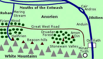 Region
in northern Gondor where Minas
Tirith was located. Anorien was north of the White Mountains, between
the Anduin and Mering
Stream. East of the Anduin was Ithilien.
West of the Mering Stream was
Rohan, which was
formerly a province of Gondor called Calenardhon. Anorien was bordered
on the north by the Mouths of the Entwash.
Region
in northern Gondor where Minas
Tirith was located. Anorien was north of the White Mountains, between
the Anduin and Mering
Stream. East of the Anduin was Ithilien.
West of the Mering Stream was
Rohan, which was
formerly a province of Gondor called Calenardhon. Anorien was bordered
on the north by the Mouths of the Entwash.
Minas Tirith was located in eastern Anorien, between the end of the White Mountains and the Anduin. The great seven-tiered city was surrounded by the rich farmlands of the Pelennor Fields. The city of Osgiliath was located on the Anduin about 15 miles northeast of Minas Tirith. The western half of the city was in Anorien while the eastern half was in Ithilien.
The Druadan Forest was in Anorien at the foot of the White Mountains west of Minas Tirith. The forest was inhabited by a race of Men called the Druedain, or Woses. The Stonewain Valley ran between the forest and the mountains. A road through the Stonewain Valley was used to transport stones from the quarries on the western side of the forest.
The seven Beacon-hills of Gondor ran from east to west through Anorien to the border of Rohan. The first three hills - Amon Din, Eilenach, and Nardol - were in the Druadan Forest. The next three hills - Erelas, Min-Rimmon, and Calenhad - stood at the foot of the White Mountains. The seventh hill - Halifirien - was in the Firien Wood on the border between Anorien and Rohan.
Part of the Firien Wood was in Anorien east of the Mering Stream, and part was west of the stream in Rohan. Over time, however, the entire forest came to be considered the domain of Rohan.
The Great West Road ran through Anorien from Minas Tirith to the Mering Stream. From there the road continued through Rohan and on through the Gap of Rohan and joined the North-South Road to Arnor.
When Gondor was founded in 3320 of the Second Age, Anorien was the domain of Elendil's younger son Anarion, while the elder son Isildur lived across the Anduin in Ithilien. Anarion established the stronghold of Minas Anor, which was later renamed Minas Tirith.
Anorien was a populous region. The people of Anorien were responsible for defending the Mering Stream, particularly in the days when Calenardhon was deserted and Gondor was vulnerable to attack from the west. The danger from the west decreased after 2510 of the Third Age when Calenardhon became Rohan - Gondor's strongest ally.
The people of Anorien were also charged with defending the crossings of the Anduin from attack by Sauron's forces in the East. The island of Cair Andros in the Anduin between Anorien and Ithilien was fortified to prevent an invasion.
During the War of the Ring on March 10, 3019, Cair Andros was captured and Anorien was invaded by an army of Orcs and Easterlings. The enemy forces blocked the Great West Road in an attempt to prevent the Rohirrim from coming to Gondor's aid. But the Rohirrim passed secretly through the Druadan Forest and the Stonewain Valley and arrived at Minas Tirith at dawn on March 15.
After the Battle of the Pelennor Fields, Elfhelm and an army of 3,000 Rohirrim routed the enemy forces from Anorien.
Names &
Etymology:
Anórien means "Sun
land" from Anor meaning "the Sun" and the ending -ien which
is a variation of a commonly used suffix in the names of countries or regions.
It was so named because it was originally the domain of Anarion. The Rohirrim
called the region Sunlending.
Sources:
The Return
of the King: "Minas Tirith," p. 19, 22, 38; "The Muster of Rohan,"
p. 77; "The Siege of Gondor," p. 95; "The Ride of the Rohirrim," p. 104,
108; "The Last Debate," p. 158; "The Black Gate Opens," p. 159; "Many Partings,"
p. 254
Appendix
A of The Lord of the Rings: "The Stewards," p. 335
Appendix
B of The Lord of the Rings: "The Tale of Years," p. 374
Unfinished
Tales: "Cirion and Eorl," p. 301, 318 note 49 (on the ending -ien);
"The Battles of the Fords of Isen," p. 369
The History
of Middle-earth, vol. V, The Lost Road and Other Writings: "The Etymologies,"
entry for ANAR
"Nomenclature
of The Lord of the Rings," entry for Sunlending
Belfalas |
Map
of Belfalas
|
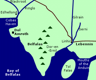 Fiefdom
of Gondor. Belfalas was located on the southern
coast on a peninsula extending into the Bay of Belfalas.
It was a populous region and the people were hardy. Many of them were of
Numenorean descent and the ruling family also had Elvish blood.
Fiefdom
of Gondor. Belfalas was located on the southern
coast on a peninsula extending into the Bay of Belfalas.
It was a populous region and the people were hardy. Many of them were of
Numenorean descent and the ruling family also had Elvish blood.
The great city of Dol Amroth was in western Belfalas on a promontory overlooking the inlet of Cobas Haven. The Elf-haven of Edhellond was just north of Dol Amroth near the mouth of the Blackroot River.
The Ringlo merged with the Blackroot on the western border of Belfalas, beyond which was the fiefdom of Anfalas. Lebennin was east of Belfalas across the rivers Gilrain and Serni. The town of Linhir was on the border between Belfalas and Lebennin.
The road that linked Minas Tirith and Erech by way of Pelargir and Linhir skirted northern Belfalas. Lamedon was north of Belfalas at the foot of the White Mountains.
There were mountains in the central part of Belfalas. The eastern coast of Belfalas is labelled on maps as Dor-en-Ernil - "Land of the Prince" - but this name probably applied to all of Belfalas.
The original inhabitants of Belfalas included fisherfolk who lived around Cobas Haven. These fisherfolk relocated to the mountains after the arrival of Elves who established the haven of Edhellond. The Elves may have come from Beleriand around 473 of the First Age or they may have come from the Grey Havens at the start of the Second Age. From Edhellond, Elves could sail to the Undying Lands. Galadriel and Celeborn may have lived on the coast in Belfalas for a short time in the late Second Age.
Men of Numenor also settled in Belfalas and built a stronghold on the site that later became Dol Amroth. These Men were among the Faithful who rejected Sauron's attempts to corrupt the Numenoreans. Numenor was destroyed in 3319 of the Second Age and Gondor was founded the next year in 3320. Belfalas became a fiefdom of Gondor. According to one story, Elendil gave the title of Prince to the leader of the Numenoreans of Belfalas. (UT, p. 316)
Dol Amroth took its name from King Amroth of Lothlorien who came to Edhellond in 1981 of the Third Age to sail to the Undying Lands. Amroth's lover Nimrodel became lost on the journey to Edhellond. Amroth's ship was swept out to Sea by a storm and he leaped overboard and drowned trying to return to land in order to find Nimrodel. The last of the Elves of Edhellond departed on the ship.
One of Nimrodel's companions named Mithrellas remained behind and married Imrazor, a Man of Numenorean descent. Their son Galador was said to be the first Prince of Dol Amroth according to one source. (HoME XII, p. 221) This appears to contradict the story that Elendil bestowed the title, although it may just be a matter of semantics in that Dol Amroth was not named until 1981.
After the line of Kings in Gondor ended in 2050, the Princes of Dol Amroth ruled Belfalas independently, although they remained loyal to the Stewards of Gondor.
The coasts of Belfalas were threatened by the fleets of the Corsairs of Umbar. The 15th Prince of Dol Amroth was killed by Corsairs in 2746. In 2758, three fleets from Umbar and Harad attacked the southern coast of Gondor and landed troops ashore. They were defeated in 2759 by Beregond, the son of the Steward Beren.
In 2976, Finduilas, the daughter of Prince Adrahil of Dol Amroth, married Denethor, who became Steward in 2984. Their children were Boromir and Faramir.
Prince Imrahil succeeded Adrahil in 3010. During the War of the Ring in 3019, Imrahil led troops from Belfalas to Minas Tirith. They fought in the Battle of the Pelennor Fields on March 15. Prince Imrahil took temporary command of Minas Tirith after the death of Denethor. He and his troops accompanied Aragorn to the Black Gate and fought in the Battle of the Morannon on March 25 until the One Ring was destroyed and Sauron was defeated.
After the war, Imrahil's daughter Lothiriel married King Eomer of Rohan. Aragorn became King of Gondor and Arnor, and the Prince of Dol Amroth was one of the King's chief commanders and a key member of the Council of Gondor.
Names &
Etymology:
The meaning of Belfalas is
uncertain. The word falas means "shore, coast" in Sindarin. In his
unfinished Index to The Lord of the Rings,
Tolkien defined the word bel as "steep, sheer" in Sindarin.
(Reader's
Companion, p. 18)
But in a later essay he wrote that Bêl was the name of the region in the language of the original inhabitants and that it meant "shore, coast" so that Belfalas was a combination of two words with the same meaning in different languages. ("Rivers & Beacon-hills," p. 15-16)
Dor-en-Ernil means "Land of the Prince." The word dor means "land" and ernil means "prince."
Sources:
The Fellowship
of the Ring: "Lothlorien," p. 354-55
The Return
of the King: "Minas Tirith," p. 20, 22, 38, 41, 43-44; "The Siege of
Gondor," p. 90, 93-94, 98, 102; "The Battle of the Pelennor Fields," p.
118, 120-24; "The Pyre of Denethor," p. 127, 131; "The Houses of Healing,"
p. 137-40, 142, 147; "The Last Debate," p. 148-49; 154-58; "The Black Gate
Opens," p. 160-61, 164-65, 168; "The Field of Cormallen," p. 231, 233;
"The Steward and the King," p. 243-44; "Many Partings," p. 254, 256
Appendix
A of The Lord of the Rings: "The Stewards," p. 334; "The House of Eorl,"
p. 352
Appendix
F of The Lord of the Rings: "The Languages and Peoples of the Third
Age - Of Men," p. 407
Unfinished
Tales: "The History of Galadriel and Celeborn," p. 240-48; "The Disaster
of the Gladden Fields," p. 286; "Cirion and Eorl," p. 293-94, 316 note
39
The Silmarillion:
"Appendix - Elements in Quenya and Sindarin Names," entry for dor
The History
of Middle-earth, vol. VII, The Treason of Isengard: "The First Map,"
p. 312, 322 note 10 (Cobas Haven)
The History
of Middle-earth, vol. XII, The Peoples of Middle-earth: "Of Dwarves
and Men," p. 313, 329 note 67
The Letters
of J.R.R. Tolkien: Letter #244
"The Rivers
and Beacon-hills of Gondor," by J.R.R. Tolkien, edited by Carl F. Hostetter,
commentary by Christopher Tolkien, in Vinyar Tengwar #42, July 2001,
p. 15-16
The Lord
of the Rings: A Reader's Companion by Wayne G. Hammond and Christina
Scull: "Prologue," p. 18-19
Source:
The Fellowship
of the Ring: "At the Sign of the Prancing Pony," p. 161
Buckland |
Map
of Buckland
|
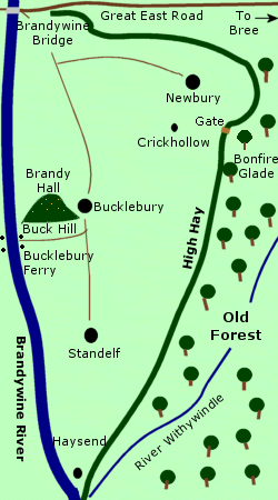 Region
on the eastern border of the Shire; home of the
Brandybuck
family. Buckland was located outside the four farthings of the Shire
on the east side of the
Brandywine River.
It was a narrow strip of land stretching from the Brandywine
Bridge at the Great East Road
in the north to the River Withywindle
in the south. On the eastern border of Buckland was the
Old
Forest.
Region
on the eastern border of the Shire; home of the
Brandybuck
family. Buckland was located outside the four farthings of the Shire
on the east side of the
Brandywine River.
It was a narrow strip of land stretching from the Brandywine
Bridge at the Great East Road
in the north to the River Withywindle
in the south. On the eastern border of Buckland was the
Old
Forest.
Buckland was settled by Hobbits in 2340 of the Third Age, when Gorhendad Oldbuck led his family across the Brandywine from the Marish. He changed the family name to Brandybuck and built Brandy Hall, an extensive Hobbit-hole in Buck Hill. The head of the Brandybuck family came to be called the Master of Buckland, and his authority was recognized not only in Buckland but also by many of the farmers in the Marish on the west side of the Brandywine. Buckland could be reached by the Brandywine Bridge or by the Bucklebury Ferry.
The Hobbits of Buckland built a tall hedge called the High Hay on their eastern border. It ran along the edge of the Old Forest for over 20 miles, from the Brandywine Bridge in the north to the Withywindle in the south. The trees of the Old Forest attacked the High Hay and the Hobbits retaliated by cutting a swath through the trees at the edge of the forest and burning them. There was a gate in the Hedge, and Bucklanders would occasionally venture into the Old Forest.
Bucklanders were considered queer by many folk in the Shire proper. In addition to their forays into the Old Forest, Bucklanders were known to travel as far as Bree. They were also familiar with boats, and some could even swim.
Buckland was densely populated. The main village was Bucklebury, around the slopes of Buck Hill. Other villages included Newbury, Standelf, and Haysend at the mouth of the Withywindle. Crickhollow was a small village northeast of Bucklebury where Frodo Baggins bought a home when he sold Bag End in the summer of 3018.
Frodo traveled to Crickhollow along with Sam Gamgee and Pippin Took on September 25. There they were greeted by Merry Brandybuck, who had arrived two days earlier to prepare for Frodo's arrival. At Crickhollow, Frodo learned that his friends Merry and Pippin intended to accompany him on his quest. They left Buckland the next morning, going through the gate in the High Hay into the Old Forest.
Names &
Etymology:
The word buck is from the
Old English bucc meaning "male deer" or bucca meaning "male
goat." Tolkien also noted that as an English place-name Buckland
is frequently derived from book-land meaning a land held by a written
charter.
Also called the East March because it was the eastern march or borderland of the Shire.
Sources:
The Fellowship
of the Ring: Map of "A Part of the Shire"; "Prologue: Of the Ordering
of the Shire," p. 18; "A Conspiracy Unmasked," p. 108-9; "The Old Forest,"
p. 121; "Fog on the Barrow-downs," p. 159
"Nomenclature
of The Lord of the Rings," entry for Brandybuck
Dimbar |
Map
of Dimbar
|
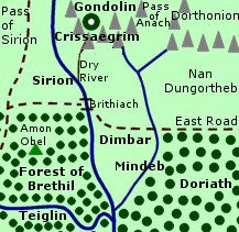 Uninhabited
region between the Forest of Brethil
and Doriath. Dimbar was located in East Beleriand,
in the angle between the Sirion and its tributary the Mindeb. Brethil lay
west of the Sirion and the Forest of Neldoreth in Doriath was east of the
Mindeb. The dangerous valley of Nan Dungortheb was also east of the Mindeb
north of Doriath.
Uninhabited
region between the Forest of Brethil
and Doriath. Dimbar was located in East Beleriand,
in the angle between the Sirion and its tributary the Mindeb. Brethil lay
west of the Sirion and the Forest of Neldoreth in Doriath was east of the
Mindeb. The dangerous valley of Nan Dungortheb was also east of the Mindeb
north of Doriath.
The East Road crossed the Sirion into Dimbar over the Ford of Brithiach. The road ran southeastward alongside the Sirion and then turned eastward across Dimbar to the Mindeb and beyond into Nan Dungortheb.
To the north, Dimbar was bordered by the mountains of Crissaegrim, which formed the southern wall of the valley of Tumladen where Gondolin was located. Thorondor and his Eagles dwelled in the peaks of Crissaegrim.
Dimbar was a desolate region. Men dwelled in the Forest of Brethil and Elves lived in Doriath, but Dimbar remained uninhabited. Initially Dimbar was at peace under the protection of Ulmo, Lord of Waters, whose power flowed through the Sirion.
In 458 of the First Age, Hurin and Huor were staying with their uncle Haldir in the Forest of Brethil when a legion of Orcs came down from the Pass of Sirion. The Men of Brethil joined forces with Beleg and the march-wardens of Doriath to defeat the Orcs. Hurin and Huor went along though both were boys in their teens. They were cut off from their company and fled to the Ford of Brithiach. The power of Ulmo caused a mist to rise from the river to hide the brothers and they escaped into Dimbar.
Hurin and Huor wandered lost in Dimbar until Thorondor saw them and sent two Eagles to carry them to Gondolin. The brothers' fates became entwined with the fate of Gondolin. Many years later, Hurin was captured by Morgoth who cursed his family when he refused to reveal the location of Gondolin. Huor's son Tuor eventually came to Gondolin and married the King's daughter Idril.
As Morgoth's power extended into Beleriand, Dimbar became vulnerable. Beleg and the march-wardens defended the northern borders of Doriath including the frontier with Dimbar. They were joined by Turin, son of Hurin, who had been sent to live in Doriath.
Turin left Doriath in 484, and Beleg went in search of him. In their absence, Dimbar was invaded by Orcs who came down from the Pass of Anach. Beleg returned to Dimbar to drive the Orcs out, but he then departed to rejoin Turin, and after he left Dimbar was retaken by Morgoth's forces.
Hurin was released from captivity by Morgoth, and in 501 he came to Dimbar seeking the entrance to Gondolin. He could not find it, but he unwittingly revealed the general location of Gondolin to Morgoth's spies. Morgoth later learned the exact location from Maeglin and he destroyed Gondolin in 510.
Names &
Etymology:
The name Dimbar means "gloomy
land" from dim meaning "sad, gloomy" in the early Elvish language
Ilkorin and bar meaning "dwelling, home" or "land."
Sources:
The Silmarillion:
"Of Beleriand and Its Realms," p. 121; "Of Maeglin," p. 132; "Of the Ruin
of Beleriand," p. 157-58; "Of Beren and Luthien," p. 176; "Of Turin Turambar,"
p. 201-2, 204-6; "Of the Ruin of Doriath," p. 227-28; "Appendix - Elements
in Quenya and Sindarin Names," entry for bar
Unfinished
Tales: "Of Tuor and His Coming to Gondolin," p. 41-44, 54 note 20;
"Narn I Hin Hurin," p. 90, 95, 147-48 note 12
The History
of Middle-earth, vol. V, The Lost Road and Other Writings: "The Etymologies,"
entries for DEM and MBAR
The History
of Middle-earth, vol. XI, The War of the Jewels: "The Grey Annals,"
p. 57
Dorwinion was located in Wilderland on the northwestern shore of the Sea of Rhun according to a map by Pauline Baynes made in consultation with J.R.R. Tolkien. The Sea of Rhun was connected to Long Lake by the River Running. Wine from Dorwinion was transported by water in barrels tied together to form rafts or loaded onto boats.
Names &
Etymology:
The name Dorwinion appears
to mean "land of wines" though the etymology is unattested. The word dor
means "land" in Sindarin. It is tempting to speculate that winion
means "of wines" - or possibly "of vines" - given the similarity to the
English word "wine."
Sources:
The Hobbit:
"Barrels out of Bond," p. 190, 192
Map of Middle-earth
by Pauline Baynes
Drúwaith Iaur (Old Púkel-land) |
Map
of Druwaith Iaur
|
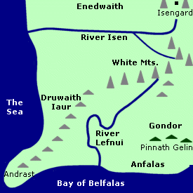 Coastal
region inhabited by the Druedain. Druwaith Iaur - or Old Pukel-land - was
on the southwest coast of Middle-earth. It was south of the River
Isen and west of the River Lefnui.
The region of Enedwaith was to the north across
the Isen, and Gondor was to the east over the
Lefnui.
Coastal
region inhabited by the Druedain. Druwaith Iaur - or Old Pukel-land - was
on the southwest coast of Middle-earth. It was south of the River
Isen and west of the River Lefnui.
The region of Enedwaith was to the north across
the Isen, and Gondor was to the east over the
Lefnui.
At the southwestern end of Druwaith Iaur was the peninsula of Andrast. The Bay of Belfalas was on the southern coast and the Sea was on the western coast. An outlier of the White Mountains extended through central Druwaith Iaur.
The race of Men called the Druedain, or Woses, lived in Druwaith Iaur. They were a fairly primitive and secretive people who hunted with poison darts. They inhabited caves in the mountains of Druwaith Iaur.
The Druedain lived throughout the White Mountains in the First Age but they were driven out during the Second Age by the Men of the Mountains. Two communities of Druedain remained - in the Druadan Forest and on Druwaith Iaur. The Men of Gondor did not make any settlements in Druwaith Iaur, although they did maintain beacons and a coast guard at the end of Andrast.
By the end of the Third Age, the Druedain in the Druadan Forest were the only ones known to still exist. However, the Men in nearby Anfalas believed that Druedain still lived secretly in Druwaith Iaur. According to one story, the Druedain of Druwaith Iaur attacked some of Saruman's forces who encroached on their territory after the Battles of the Fords of Isen.
Names &
Etymology:
The name Drúwaith Iaur
means "old wilderness of the Dru-folk." The term "old" is used in the sense
of "former" (although some Druedain may have remained there secretly).
The name Drû is a Sindarin adaptation of Drughu which
was the Druedain's own name for themselves. The ending waith is
from gwaith which means "people" but is also used for regions.
Also called Old Púkel-land and Old Púkel-wilderness. The word púkel is from the Anglo-Saxon púcel meaning "goblin, demon." Púkel-men was the name given to statues resembling the Druedain in Rohan.
Sources:
Unfinished
Tales: "The Druedain," p. 383-84, 385 note 6, 387 notes 13 and 14
"The Rivers
and Beacon-hills of Gondor," by J.R.R. Tolkien, edited by Carl F. Hostetter,
commentary by Christopher Tolkien, in Vinyar Tengwar #42, July 2001,
p. 14
Dunland |
Map
of Dunland
|
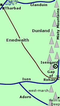 Land
west of Rohan inhabited by Men hostile to the
Rohirrim. Dunland was located at the foot of the Misty
Mountains at the southwestern end of the range. It was in the region
called Enedwaith. The northern part of Dunland
was a pleasant, green country. Dunland was bordered on the north by the
River
Glanduin. To the west ran the great North-South
Road, and to the south was the River Isen
which flowed through the Gap of Rohan.
Land
west of Rohan inhabited by Men hostile to the
Rohirrim. Dunland was located at the foot of the Misty
Mountains at the southwestern end of the range. It was in the region
called Enedwaith. The northern part of Dunland
was a pleasant, green country. Dunland was bordered on the north by the
River
Glanduin. To the west ran the great North-South
Road, and to the south was the River Isen
which flowed through the Gap of Rohan.
Dunland was primarily inhabited by Men. The Dunlendings were swarthy and dark-haired. They spoke their own language which was different from the Common Speech. Some of the Dunlendings kept herds of livestock.
The ancestors of the Dunlendings came from the White Mountains, and they were distantly related to the Men of the Mountains who were later cursed by Isildur to haunt the Paths of the Dead. The Dunlendings' ancestors migrated northward from the White Mountains probably during the early part of the Second Age. They settled in the valleys of the southwestern Misty Mountains. Men also originally lived in scattered communities throughout the forests of Enedwaith, but the forests were cut down by the Numenoreans and the population became concentrated at the foot of the mountains in the area that became known as Dunland.
After the Kingdoms of Gondor and Arnor were founded in 3320 of the Second Age, Dunland and the larger region of Enedwaith became nominally part of Gondor. But the Men of Gondor never settled the region, so Enedwaith was essentially a borderland between Gondor and Arnor.
Around 1150 of the Third Age, a group of Hobbits of the Stoor branch settled in Dunland. They remained there for almost 500 years until 1630, when they left Dunland to join many other Hobbits in the Shire.
The Great Plague of 1636 caused suffering in Dunland, but because the Dunlendings kept themselves isolated they were not as badly affected as other peoples in Middle-earth. After the line of Kings ended in 2050, Gondor's power began to wane and the Dunlendings were no longer even nominally subjects of Gondor.
On the other side of the Misty Mountains from Dunland was the region of Gondor called Calenardhon. The population of Calenardhon diminished as Gondor began to focus its resources in the east where Sauron was rising to power. The Dunlendings began to cross the Gap in the mountains into Calenardhon to make settlements.
But in 2510, Calenardhon was given to the people of Eorl the Young and became the land of Rohan. During the reigns of King Brego and King Aldor of Rohan, the Dunlendings were driven out of Rohan, and the Rohirrim raided Dunland. The Dunlendings hated the Rohirrim and became their enemies.
The Dunlendings began to cross the border into Rohan again around 2700. They stole horses and made settlements in the northern Westfold and in the eaves of Fangorn Forest and around Isengard. Isengard was an outpost of Gondor, but the line of Gondorian chieftains stationed there had died out. Rule of the stronghold had been taken over by a local family who had mixed Dunlendish blood. They let the Dunlendings into Isengard.
King Deor of Rohan defeated a force of Dunlendings in the Westfold in 2710, but he could not retake Isengard from them. Egalmoth, the Steward of Gondor, was unable to send any help, so Isengard remained occupied by the Dunlendings for the time being.
West of the Gap of Rohan between the River Isen and the River Adorn was a region called the west-march. The west-march was officially part of Rohan but many of its inhabitants were akin to the Dunlendings. A wealthy and powerful man named Freca set up his own domain there around the Adorn. He claimed to be descended from King Freawine of Rohan, but he was also part Dunlending. Freca largely ignored the rule of King Helm of Rohan except when it suited his purposes.
In 2754, Freca attended one of Helm's council meetings. Freca wanted his son Wulf to marry Helm's daughter. Helm laughed at Freca's insolence, and Freca insulted the King. After the meeting, Helm struck Freca with one blow from his fist, and Freca died.
Freca's son Wulf led the Dunlendings in an invasion of Rohan in 2758. Gondor was attacked at the same time by Corsairs of Umbar and Men of Harad. Some of the Corsairs and Haradrim joined with the Dunlendings in invading Rohan from the west, and Rohan was also invaded by enemies from the east.
Wulf captured Edoras and sat on the throne in Meduseld. Many of the Rohirrim were killed or enslaved, and the survivors fled to mountain refuges. Helm led many to the stronghold that became known as Helm's Deep, while his nephew Frealaf led others to Dunharrow. Then the Long Winter came and many of the Rohirrim starved. Helm made a number of raids on the enemy camps and killed many Dunlendings until he himself perished. The Dunlendings feared Helm and they started a false rumor that he ate his victims, which added to their hatred of the Rohirrim.
In the spring of 2759, Frealaf took back Edoras and killed Wulf. The Dunlendings were driven out of Rohan and out of Isengard. The Steward of Gondor gave Isengard to Saruman the White in hope that the Wizard would help protect Rohan's western border against future invasions.
A group of Dwarves came to live in Dunland shortly after Smaug the Dragon captured the Lonely Mountain from them in 2770. The Dwarves were led by Thror, and among them were his son Thrain II and his grandson Thorin Oakenshield. They lived in Dunland for only a short time. Many left to fight the War of the Dwarves and the Orcs from 2793 to 2799. Afterwards some of the survivors returned briefly to Dunland before relocating to the Blue Mountains in 2802.
Although the Dunlendings had been driven out of Rohan, they had continued to occupy the west-march between the Isen and the Adorn. King Folcwine of Rohan reclaimed the west-march from the Dunlendings. But the people that remained there were of mixed blood and many still blamed the Rohirrim for the death of their lord Freca.
The Dunlendings and the people of the west-march made secret alliances with Saruman, who intended to conquer Rohan. The Wizard inflamed their hatred of the Rohirrim. Many Dunlendings joined his growing armies. Saruman also apparently experimented with cross-breeding Orcs and Men, and he may have used Dunlendings for this purpose.
One of Saruman's most trusted servants was a Man of Dunland who appeared to have Orc blood. This squint-eyed Southerner was Saruman's chief agent in his dealings with the Shire. Saruman sent him and other agents from Dunland to buy pipe-weed from the Shire and to act as spies because he was suspicious of Gandalf's interest in Hobbits.
Frodo Baggins and his companions saw the squint-eyed Southerner at the Prancing Pony in Bree in September of 3018. In 3019, many of Saruman's Dunlendish agents moved into the Shire and began bullying and oppressing the Hobbits.
Dunlendings fought against the Rohirrim at the Battles of the Fords of Isen and the Battle of Helm's Deep. Saruman's forces were defeated at Helm's Deep, and many of the Dunlendings surrendered. They were afraid because Saruman had told them that the Rohirrim burned their captives alive, and they were surprised to find that the Rohirrim were merciful. The Dunlendings were set to work burying the dead and repairing the damage to Helm's Deep.
Afterwards, the Dunlendings were allowed to return home to Dunland. But first they swore an oath that they would never again wage war against Rohan or join forces with the enemies of Men. The Dunlendings sent ambassadors to Gondor following the coronation of Aragorn, King Elessar. On November 3, 3019, Saruman's Dunlendish agents were expelled from the Shire by the Hobbits in the Battle of Bywater - the last battle of the War of the Ring.
Names &
Etymology:
The names Dunland and Dunlending
were in the language of the Rohirrim. The names contain the Old English
word dunn meaning "brown" in reference to the dark hair of the Men
of Dunland. The name is said to have no relation to the Elvish word dûn
meaning "west," nor apparently is it related to the Old English dún
meaning "hill."
Sources:
The Fellowship
of the Ring: "Prologue - Concerning Hobbits," p. 12; "At the Sign of
the Prancing Pony," p. 168, 172; "Strider," p. 186; "The Council of Elrond,"
p. 278; "The Ring Goes South," p. 298
The Two
Towers: "Helm's Deep," p. 132, 138, 142; "The Road to Isengard," p.
150; "Flotsam and Jetsam," p. 171, 180
The Return
of the King: "The Passing of the Grey Company," p. 50; "The Steward
and the King," p. 247; "Many Partings," p. 261, 263; "The Scouring of the
Shire," passim
Appendix
A of The Lord of the Rings: "The
House of Eorl," p. 346-50; "Durin's Folk," p. 354, 357
Appendix
B of The Lord of the Rings: "The Tale of Years," p. 366-67, 369
Appendix
F of The Lord of the Rings: "The Languages and Peoples of Middle-earth,"
p. 405, 407-8
Unfinished
Tales: "The History of Galadriel and Celeborn," p. 262-64; "The Hunt
for the Ring," p. 347-49; "The Battles of the Fords of Isen," p. 359, 362,
364-5 note 4, 369-73
The History
of Middle-earth, vol. XII, The Peoples of Middle-earth: "Of Dwarves
and Men," p. 314, 329 note 69, 330 note 76
Enedwaith |
Map
of Enedwaith
|
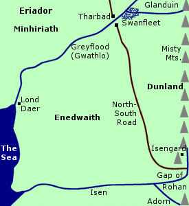 Region
south of Eriador. Enedwaith was located between
the Misty Mountains and the Sea. Dunland
was in eastern Enedwaith at the foot of the Misty Mountains. The Isen
was the southern boundary of Enedwaith and the Greyflood
and Glanduin formed its northern boundary.
Region
south of Eriador. Enedwaith was located between
the Misty Mountains and the Sea. Dunland
was in eastern Enedwaith at the foot of the Misty Mountains. The Isen
was the southern boundary of Enedwaith and the Greyflood
and Glanduin formed its northern boundary.
North of the Greyflood was the region of Eriador called Minhiriath. The Elvish realm of Eregion was north of the Glanduin. The marshlands of Swanfleet were around the junction of the Greyflood and Glanduin.
The city of Tharbad was located on the Greyflood between Enedwaith and Minhiriath. The port of Lond Daer was in Enedwaith on the seacoast at the mouth of the Greyflood. The North-South Road connecting Gondor and Arnor ran through Enedwaith from the Gap of Rohan to Tharbad.
Enedwaith was originally covered with vast forests. The woods were inhabited by a large number of Men in scattered, autonomous communites. Between 750 and 800 of the Second Age, Aldarion of Numenor established the haven of Lond Daer. Tharbad was built sometime afterwards. The Numenoreans began cutting down trees to use for building ships and this practice continued for centuries. Eventually most of Enedwaith was completely deforested except for some woodlands in the southeast.
The native inhabitants of Enedwaith became hostile to the Men of Numenor as their homeland was ravaged. Some of them even sided with Sauron when the Numenoreans aided the Elves during the War of the Elves and Sauron of 1693 to 1701. The natives acted as spies and guides for Sauron's forces. Sauron was defeated in the Battle of the Gwathlo (another name for the Greyflood) in 1701.
The population of Enedwaith had dwindled as the forests were destroyed. A number of fisher-folk still lived along the seacoast between the Greyflood and the Isen. Many of the other surviving inhabitants settled at the foot of the Misty Mountains in what became Dunland. (See the Dunland entry above for the history of that land.)
The Kingdoms of Gondor and Arnor were established in 3320 by the survivors of the Downfall of Numenor. The North-kingdom of Arnor encompassed most of Eriador north of the Greyflood. At the height of its power, the South-kingdom of Gondor's territory extended as far north as the Greyflood and included Enedwaith. But the Men of Gondor never settled in Enedwaith and in time Gondor's boundaries receded. Enedwaith became a borderland between the two Kingdoms.
The Men of Gondor maintained and patrolled the portion of the North-South Road that passed through Enedwaith. The bridge and town of Tharbad were the responsibility of both Kingdoms. A number of people from Gondor and Arnor lived in Tharbad during the first half of the Third Age.
In 1636 of the Third Age, the Great Plague swept through Middle-earth. The native inhabitants of Enedwaith were affected and the population of Tharbad also declined as Gondor and Arnor were weakened. The North-South Road fell into disuse and became overgrown. In 2912, Enedwaith was devastated by floods during the spring thaw that followed the Fell Winter. The bridge at Tharbad collapsed and the town was ruined and deserted.
Frodo Baggins and his companions passed through Enedwaith on their way home in late August and early September of 3019.
Names &
Etymology:
Also spelled Enedhwaith.
The name Enedwaith means "middle folk" or "middle region" in Sindarin
from enedh meaning "middle" and waith from gwaith
which means "people" but is also used for regions. The name was also interpreted
as "Central Wilderness"
(HoME XII, p. 330).
Sources:
Unfinished
Tales: "Aldarion and Erendis," p. 206; The History of Galadriel and
Celeborn," p. 239, 261-65; "The Hunt for the Ring," p. 341, 347-48; "The
Battles of the Fords of Isen," p. 356, 369-70, 372; "The Druedain," p.
383, 386-87 notes 9 and 13
Appendix
A of The Lord of the Rings: "Gondor and the Heirs of Anarion," p. 325
Appendix
B of The Lord of the Rings: "The Tale of Years," p. 370
Appendix
F of The Lord of the Rings: "The Languages and Peoples of Middle-earth,"
p. 407-8
The Silmarillion:
"Appendix - Elements in Quenya and Sindarin Names," entry for gwaith
The History
of Middle-earth, vol. V, The Lost Road and Other Writings: "The Etymologies,"
entry for ened
The History
of Middle-earth, vol. XII, The Peoples of Middle-earth: "Of Dwarves
and Men," p. 313-14, 328 note 66, 329 note 69, 330 note 76
Letters
of J.R.R. Tolkien:
Letter #168
Eregion (Hollin) |
Map
of Eregion
|
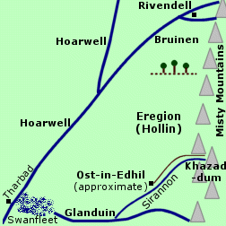 Realm
of the Elven-smiths who forged the Rings of Power. Eregion was located
in Eriador along the western side of the Misty
Mountains. The southern boundary of Eregion was the River
Glanduin. The northern boundary was about 45 leagues, or 135 miles,
south of Rivendell, marked by a ridge topped
with holly trees. Eregion was noted for the holly trees that grew there,
and the region was called Hollin in the Common Speech.
Realm
of the Elven-smiths who forged the Rings of Power. Eregion was located
in Eriador along the western side of the Misty
Mountains. The southern boundary of Eregion was the River
Glanduin. The northern boundary was about 45 leagues, or 135 miles,
south of Rivendell, marked by a ridge topped
with holly trees. Eregion was noted for the holly trees that grew there,
and the region was called Hollin in the Common Speech.
The chief city of Eregion was Ost-in-Edhil. The city's exact location is not known, but it was probably along the Sirannon, or Gate-stream of Khazad-dum. A paved road ran from Ost-in-Edhil along the Sirannon to the West-gate of Khazad-dum. Two holly trees stood at the gate, marking the end of the Elvish lands and the entrance to the Dwarves' realm. There was also a road leading through Eregion to the Pass of Caradhras, which led over the Misty Mountains to the Dimrill Dale.
Eregion was founded in the year 750 of the Second Age by a group of Noldorin Elves who had survived the War of Wrath against Morgoth at the end of the First Age. Beleriand had been destroyed, so they migrated eastward and settled at the foot of the Misty Mountains. According to some accounts, Galadriel and Celeborn accompanied them and lived in Eregion for a time.
The Elves built Ost-in-Edhil, and there they established the House of the Mirdain, or jewel-smiths. They became known as the Gwaith-i-Mirdain, or People of the Jewel-smiths. The Elven-smiths of Eregion made many beautiful things. The greatest of the Elven-smiths was Celebrimbor, who was the grandson of Feanor.
The Elven-smiths traded with the Dwarves of Khazad-dum. The Dwarves were skilled craftsmen and they mined under the mountains for jewels and metals and especially for mithril. Mithril was found nowhere else in Middle-earth, and it was the main reason the Elven-smiths had chosen to settle there. Celebrimbor became friends with the Dwarf craftsman Narvi, and together they made the great Doors of Durin for the West-gate of Khazad-dum.
In 1200, Sauron came to Eregion in a fair disguise, calling himself Annatar, Lord of Gifts. He claimed to be an emissary of the Valar, and he promised to teach the Elves many things. The Elven-smiths greatly desired to improve their skills and craftsmanship. Although they had chosen to remain in Middle-earth, they wanted to recreate the beauty and timelessness of the Undying Lands. Sauron played on these desires, and the Elven-smiths were deceived and welcomed him into Eregion.
Under Sauron's instruction, the Elves began to make magic rings. While learning the craft, they made a number of lesser rings with varying degrees of power. Then around 1500, they began the forging of the Rings of Power. The Elven-smiths made nineteen Rings of Power in total. The Seven Rings and the Nine Rings were made with Sauron's help. In 1590, Celebrimbor made the Three Rings - Narya, Nenya, and Vilya - without Sauron's aid, though he used the skills he had learned from him.
Sauron returned to Mordor and in 1600 he forged the One Ring to rule the other Rings of Power. As soon as Sauron put on the One Ring, the Elves became aware of him and realized his true identity. Knowing they had been deceived, the Elves took off their Rings so that Sauron could not control them.
Sauron was enraged, and in 1693 he declared war against the Elves and demanded the Rings of Power from them. The Elves hid the Three Rings. Galadriel received Nenya, while Narya and Vilya were sent to Gil-galad in Lindon. The Nine Rings remained in Eregion, as did six of the Seven Rings. According to Dwarf legend, one of the Seven had already been given by the Elves to Durin III, the King of Khazad-dum.
Sauron invaded Eriador and attacked Eregion. Celeborn led a sortie against the vanguard of Sauron's army. He joined forces with a host of reinforcements from Lindon led by Elrond, but the Elves were greatly outnumbered and were driven back. Sauron besieged Eregion and broke through the defenses in 1697.
Celebrimbor tried to defend the House of the Mirdain where the Rings were kept, but he was overcome. Sauron entered the House and seized the Nine Rings. He tortured Celebrimbor into revealing the location of the Seven Rings, six of which he retrieved. But Celebrimbor would not reveal where the Three Rings were hidden, and Sauron had him put to death.
Sauron was eventually defeated and driven back to Mordor by the Elves of Lindon and the Men of Numenor. But Eregion had been completely destroyed, and it was abandoned. Many of the survivors fled to Edhellond or the Grey Havens to set sail to the Undying Lands. Still others, possibly including Galadriel and Celeborn, went to live in Lothlorien.
In the Third Age, Eregion was an empty and uninhabited region, and nothing remained of the realm of the Elves but a few overgrown roads and ruins. The Fellowship passed through the region in January of 3019. Legolas said of the Elves who once lived there: "... the trees and the grass do not now remember them. Only I hear the stones lament them: deep they delved us, fair they wrought us, high they builded us; but they are gone." (FotR, p. 297)
Names &
Etymology:
The name Eregion means "Land
of Holly" from ereg meaning "holly tree" and the ending -ion
which appears to denote "land of." The Common Speech name was Hollin.
Sources:
The Fellowship
of the Ring: "The Shadow of the Past," p. 56; "The Council of Elrond,"
p. 255, 266-67; "The Ring Goes South," p. 295-300; "A Journey in the Dark,"
p. 308-18
The Return
of the King: "Many Partings," p. 263
Appendix
B of The Lord of the Rings: "The Tale of Years," p. 363-64
Unfinished
Tales: "The History of Galadriel and Celeborn," p. 234-39, 243-44,
250-52, 254-55, 264
The Silmarillion:
"Of the Rings of Power and the Third Age," p. 286-88 and index entry (definition
of Eregion)
The History
of Middle-earth, vol. V, The Lost Road and Other Writings: "The Etymologies,"
entry for EREK
The Letters
of J.R.R. Tolkien: Letter #131
The sons of Feanor settled in East Beleriand in the year 7 of the First Age. Amrod and Amras dwelled in the southern regions and their domain included the area later known as Estolad.
The Men of the House of Beor crossed the Blue Mountains into Beleriand in 310. At first they camped in northern Ossiriand. But the Green-elves of that land sent a message to Finrod Felagund, who had befriended the Men, to ask them to leave. The Men crossed the Gelion and settled on the banks of the Celon south of Nan Elmoth. Their new home was named Estolad, meaning "the Encampment."
In 311, Beor accompanied Finrod to Nargothrond and never came back to Estolad. His son Baran became the leader of their people. In 313, another group of Men known as the People of Marach came to Estolad. Their homes were to the south and east of those of the Men of the House of Beor. The two groups became friends and allies.
Finrod frequently visited Estolad. With him came other Elves who had never seen Men before. The Elves invited the Men to relocate to their realms. Some Men entered the service of the Elf-lords, including Marach's son Malach who went to Hithlum in 322 to join the household of Fingolfin, High King of the Noldor.
From 330 to 380, many thousands of Men left Estolad to settle elsewhere in Beleriand. The Men of the House of Beor relocated to Dorthonion. Marach stayed in Estolad until his death in 376, but most of his people relocated westward. Some went to Hithlum, while Marach's grandson Magor led many others to live in the valleys of the southern slopes of the Ered Wethrin.
But a number of Men remained in Estolad. Some did not want to journey any further, while others feared the Elves. Some became discontented with their situation because they had come to Beleriand to find peace but instead found themselves in the middle of a war between the Elves and Morgoth. The leaders of the discontent were Bereg of the House of Beor and Amlach of the People of Marach.
In 369, a council was held in Estolad to discuss the matter. Morgoth sent a false image of Amlach to speak out against the Elves in hopes of turning the Men against them. Although Morgoth's trick was revealed, many Men still wanted to leave in order to avoid his wrath. Bereg led a thousand Men of the House of Beor away southwards. Amlach repented and joined Maedhros on Himring, but a number of his followers chose a new leader and crossed the Blue Mountains into Eriador.
In 376, a new group of Men arrived in Estolad led by Haleth. They had been living in Thargelion until Morgoth sent Orc raiders to attack them. The People of Haleth stayed in Estolad until 390, when they relocated to the Forest of Brethil.
It is said that some Men continued to live in Estolad "until in the ruin of Beleriand they were overwhelmed or fled back into the East." (Sil., p. 144) This may refer to the Battle of Sudden Flame in 455, during which East Beleriand was invaded by Morgoth's forces, or it may refer to the destruction of Beleriand in the War of Wrath at the end of the First Age.
Names &
Etymology:
The name Estolad means "the
Encampment." The origin of the word is uncertain.
Sources:
The Silmarillion:
"Of the Coming of Men into the West," p. 142-46
The History
of Middle-earth, vol. XI, The War of the Jewels: "The Grey Annals,"
p. 112; "The Later Quenta Silmarillion," p. 218-22, 226-28, 233; "Maeglin,"
p. 334
Forodwaith |
Map
of Forodwaith
|
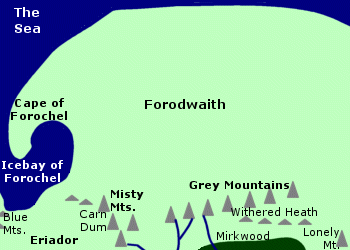 The
Northern Waste. Forodwaith was located in the far north of Middle-earth.
The region was bordered on the south by the Grey
Mountains and the northern end of the Misty
Mountains, and it extended north as far as the Sea. On the west coast
of Forodwaith was the Icebay of Forochel.
The Cape of Forochel extended into
the bay.
The
Northern Waste. Forodwaith was located in the far north of Middle-earth.
The region was bordered on the south by the Grey
Mountains and the northern end of the Misty
Mountains, and it extended north as far as the Sea. On the west coast
of Forodwaith was the Icebay of Forochel.
The Cape of Forochel extended into
the bay.
Forodwaith had an extremely cold climate. Storms and weather fronts from Forodwaith sometimes affected the rest of Middle-earth. In 1981 of the Third Age, Amroth's ship was blown out into the Bay of Belfalas in southern Middle-earth by a great storm that came down from Forodwaith.
Forodwaith was inhabited by the Lossoth, or Snowmen. The Lossoth were descendants of an earlier race of people called the Forodwaith who had lived in the North when Morgoth dwelled there. Morgoth's realm had been destroyed in the War of Wrath at the end of the First Age and much of the land had sunk beneath the Sea.
The Lossoth were a hardy people who were accustomed to the cold. They lived in igloos and travelled using skis and sleds. They kept to themselves in their remote land and were rarely encountered by other peoples of Middle-earth.
The Lossoth mainly lived on the Cape of Forochel, but they sometimes migrated to the southern shore of the Icebay which was in Eriador. There in 1974 of the Third Age they encountered Arvedui, the Last King of Arthedain in the North-kingdom, who was fleeing from the Witch-king of Angmar. The Lossoth gave Arvedui and his followers food and built them shelters.
In 1975, Arvedui boarded a ship that came to rescue him despite the warnings of the Lossoth chief. The ship was wrecked in a blizzard that came down from the North and all aboard were killed. The Lossoth later told the Dunedain what had happened and sold them the Ring of Barahir which Arvedui had given them.
Dragons also lived in Forodwaith. Around 2570, Dragons from the Northern Waste began to trouble the Dwarves of the Grey Mountains. Dain I and his son Fror were killed by a Cold-drake in 2589 and the Dwarves abandoned the Grey Mountains. Some led by Gror went to the Iron Hills while others led by Thror went to the Lonely Mountain. But the Dwarves of the Lonely Mountain were driven away by the great Dragon Smaug who came out of the North in 2770. Smaug was later killed by Bard the Bowman.
Names &
Etymology:
Also called the Northern Waste.
The name Forodwaith means both "north region" and "north people" in Sindarin. The word forod means "north." The element waith is from gwaith which means "people" but is also used for regions. Forodwaith was the name of the area and its original inhabitants.
The name Lossoth means "snow men" in Sindarin from loss meaning "snow" and hoth meaning "horde, host."
Sources:
The Hobbit:
"An
Unexpected Party," p. 31-32
Appendix
A of The Lord of the Rings: "The North-kingdom and the Dunedain," p.
321-22 and note 1; "Durin's Folk," p. 353
Appendix
B of The Lord of the Rings: "The Tale of Years," p. 368-69
Unfinished
Tales: "Introduction," p. 13-14; "The History of Galadriel and Celeborn,"
p.
242
The Silmarillion:
"Appendix
- Elements in Quenya and Sindarin Names," entries for formen,
gwaith,
hoth and los
The History
of Middle-earth, vol. VII, The Treason of Isengard: "The First Map,"
p. 301 and maps I and IA
Letters
of J.R.R. Tolkien: Letter #168
Khand |
Map
showing the location of Khand
|
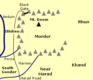 Land
in southeastern Middle-earth. Khand was located southeast of Mordor.
Rhun
was north of Khand, and Harad was to the southwest.
Khand was inhabited by people called the Variags.
Land
in southeastern Middle-earth. Khand was located southeast of Mordor.
Rhun
was north of Khand, and Harad was to the southwest.
Khand was inhabited by people called the Variags.
In the 1900s of the Third Age, the people of Khand came into conflict with the Wainriders of Rhun, who were expanding southward. But then the Wainriders made an alliance with Khand and with Harad. Their common enemy was Gondor.
In 1944, they attacked Gondor on two fronts. The Haradrim invaded Ithilien from the south while the Wainriders and the Men of Khand attacked from the northeast. They gathered near the Sea of Rhun and then marched alongside the Ash Mountains to the Black Gate of Mordor, where they took the Northern Army of Gondor by surprise and defeated them. King Ondoher of Gondor and both his sons were killed.
The Southern Army of Gondor led by Earnil first defeated the Haradrim and then attacked the Wainriders after they made camp to celebrate their victory. The Wainriders were routed in the Battle of the Camp and many fled into the Dead Marshes where they perished. The fate of the Men of Khand is not recorded, but it seems likely that they met the same end as their allies.
During the War of the Ring, Variags of Khand were allied with Sauron. They fought in the Battle of the Pelennor Fields on March 15, 3019. They were held in reserve in Osgiliath and were sent onto the battlefield by Gothmog after the death of the Lord of the Nazgul. The Variags were eventually driven back by the Knights of Dol Amroth. Sauron's forces were defeated that day by the Men of Gondor and Rohan.
Names &
Etymology:
The meanings of Khand and
Variag
are not known. These names are in the language of the people of that region.
In our own history, Variag is another name for Varangian. The Varangians were a Viking people who expanded eastward from Scandinavia into Russia. Their name may have been derived from the Old Norse Væringjar, possibly defined as "sworn men" from várar meaning "pledge, troth." Khand is a word meaning "realm" in India.
Sources:
The Return
of the King: "The Battle of the Pelennor Fields," p. 121, 123
Appendix
A of The Lord of the Rings: "Gondor and the Heirs of Anarion," p. 329
Unfinished
Tales: "Cirion and Eorl," p. 291-92
The History
of Middle-earth, vol. XII, The Peoples of Middle-earth: "Appendix on
Languages," p. 79
Wikipedia
article on Varangians
On March 9, 3019 of the Third Age, Aragorn led the Grey Company and the Dead east from Erech. They passed through Tarlang's Neck and entered Lamedon. Calembel was deserted, for many of the people had fled to the hills and the Men had gone to war. Some of the hillmen of Lamedon had gone to Minas Tirith, which they reached on March 9. Lord Angbor and his Men had gone to the fords of the River Gilrain near Linhir, where they fought the Men of Umbar and Harad.
Aragorn reached Linhir on March 11 and told Angbor - the only Man who did not flee before the Dead - to bring his Men to Pelargir. The Men of Lamedon arrived at Pelargir on March 13. They then went to Minas Tirith, some with Aragorn on the ships seized from the Corsairs and some marching north with Lord Angbor.
Names &
Etymology:
The name Lamedon is in the
language of the area's original inhabitants before the coming of the Numenoreans.
The meaning is not known.
Sources:
The Return
of the King: "Minas Tirith," p. 43; "The Passing of the Grey Company,"
p. 63; "The Battle of the Pelennor Fields," 123; "The Last Debate," 150-51,
153, 157
"The Rivers
and Beacon-hills of Gondor," by J.R.R. Tolkien, edited by Carl F. Hostetter,
commentary by Christopher Tolkien, in Vinyar Tengwar #42, July 2001,
p. 17
The Lord
of the Rings: A Reader's Companion by Wayne G. Hammond and Christina
Scull: "Minas Tirith," p. 525
Lebennin |
Map
of Lebennin
|
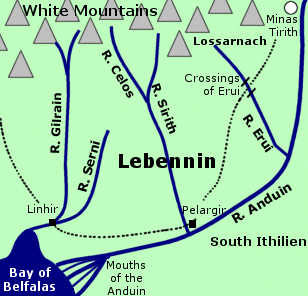 Fiefdom
in southern Gondor. Lebennin was located south
of the White Mountains. The Anduin
flowed in a wide curve to form Lebennin's southern boundary, emptying into
the
Bay of Belfalas at the Mouths
of the Anduin. The western boundary of Lebennin was the River
Gilrain. The Gilrain was one of the five rivers of Lebennin; the others
were the Serni, the Celos,
the Sirith, and the Erui.
Fiefdom
in southern Gondor. Lebennin was located south
of the White Mountains. The Anduin
flowed in a wide curve to form Lebennin's southern boundary, emptying into
the
Bay of Belfalas at the Mouths
of the Anduin. The western boundary of Lebennin was the River
Gilrain. The Gilrain was one of the five rivers of Lebennin; the others
were the Serni, the Celos,
the Sirith, and the Erui.
The lands of Belfalas and Lamedon lay to the west of Lebennin. South Ithilien was across the Anduin to the east. To the northeast was Lossarnach in the vales of the White Mountains, and further north was the great city of Minas Tirith.
Lebennin was a fair land with fields of tall green grass and flowers, including lilies, alfirin, and mallos. The town of Linhir was located at the fords near the juncture of the Gilrain and Serni. Pelargir was a major port on the Anduin near the mouth of the Sirith. A road led south from Minas Tirith through Lebennin to Pelargir and then west to Linhir and beyond.
The people of Lebennin were a hardy folk. They were generally of mixed blood, descended from both the tall, fair Dunedain and the shorter, swarthier Men who had lived in the area before Gondor was founded. Fisher-folk dwelled around the Mouths of the Anduin. Lebennin was noted for its clear-voiced singers.
In 1447 of the Third Age, the Battle of the Crossings of Erui was fought in Lebennin against the forces of Castamir, who had usurped the throne of Gondor. Many of the best Men of Gondor died in the battle. Eldacar, the rightful King, slew Castamir, and the rebels retreated to Pelargir before they fled to Umbar.
During the War of the Ring, Lebennin was threatened by the Corsairs of Umbar. On March 7, 3019, word was sent from Lebennin to Minas Tirith warning that a great fleet was approaching the Mouths of the Anduin. Pelargir was captured and the Corsairs' fleet assembled there with the intention of sailing up the Anduin to attack Minas Tirith.
But Aragorn had learned of this threat, and on March 11 he led the Grey Company and the Dead across the fords at Linhir. They crossed Lebennin and arrived at Pelargir on March 13, where they defeated the Corsairs and captured their fleet. Aragorn then sailed to the aid of Minas Tirith, accompanied by many valiant Men of Lebennin who fought in the Battle of the Pelennor Fields on March 15.
Names &
Etymology:
Lebennin means "Five Rivers"
from leben meaning "five" and nin meaning "waters."
Sources:
Map of
Gondor by Christopher Tolkien
The Return
of the King: "Minas Tirith," p. 22, 36, 38; "The Siege of Gondor,"
p. 89; "The Battle of the Pelennor Fields," p. 122, 123; "The Last Debate,"
p. 149, 151-53; "The Steward and the King," p. 243
Appendix
A of The Lord of the Rings: "Gondor and the Heirs of Anarion," p. 327
Appendix
B of The Lord of the Rings: "The Tale of Years," p. 374
The History
of Middle-earth, vol. V, The Lost Road and Other Writings: "The Etymologies,"
entries for LEP/LEPET and NEN
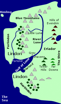
Lindon |
Map
of Lindon
|
 Elvish
lands west of the Blue Mountains. Lindon
was located in far northwestern Middle-earth on the shore of the Sea. It
was a fair, green coastal land.
Elvish
lands west of the Blue Mountains. Lindon
was located in far northwestern Middle-earth on the shore of the Sea. It
was a fair, green coastal land.
Lindon was divided into two regions by the Gulf of Lune. North of the Gulf of Lune was Forlindon, and south of the Gulf was Harlindon. The Grey Havens were located at the head of the Gulf. The Gulf had two small inlets: Forlond on the northern side and Harlond on the southern side.
There were woods at the foot of the Blue Mountains in Forlindon and Harlindon. A river flowed southward through Forlindon from the mountains to the Gulf.
The Elvish lands also extended east of the Blue Mountains to the River Lune as far north as the Little Lune. North of the Little Lune was Dwarf country, and Dwarves also lived in the Blue Mountains. East of the River Lune was Eriador, where the North-kingdom of Arnor was established by the Dunedain.
Lindon was originally part of Beleriand - a great land that lay west of the Blue Mountains in the First Age. Lindon was another name for the region of Ossiriand, the Land of Seven Rivers, where the Green-elves lived. But in the War of Wrath with Morgoth at the end of the First Age, Beleriand was ruined and most of the land sank beneath the Sea. All that remained was strip of coastal land and a few islands.
Some of the Elves of Beleriand decided to remain in Middle-earth and they settled in the coastal region which they called Lindon. Lindon and the Grey Havens were established in the year 1 of the Second Age.
The ruler of the Elves of Lindon was Gil-galad. He lived in Forlindon, where the people were mainly Noldorin Elves. Harlindon was populated by many Sindarin Elves including Celeborn, who may have ruled a fiefdom there under Gil-galad for a time before he and his wife Galadriel moved eastward into Eriador. Cirdan and many other Elves lived at the Grey Havens, where they built and maintained ships that were used by Elves who wanted to leave Middle-earth and sail to the Undying Lands.
In the year 600 of the Second Age, ships from Numenor first came to Middle-earth and landed at the Grey Havens. The Numenorean captain Veantur brought his grandson Aldarion to Lindon in 725. Gil-galad and the Elves of Lindon welcomed and befriended the Men of Numenor.
In 1200, Sauron tried to gain entry into Lindon. He had assumed a fair form and claimed to be an emissary of the Valar. Gil-galad did not know he was Sauron, but he was suspicious and turned him away. Sauron went instead to Eregion, where he deceived the Elves and instructed them in the making of the Rings of Power. Around 1600, Sauron forged the One Ring to rule the other Rings.
Sauron declared war against the Elves in 1693 when they hid the Three Rings from him. Gil-galad sent an army of Elves from Lindon led by Elrond to help defend Eregion, but they were outnumbered and Eregion was destroyed. By 1700, Sauron's forces had reached the border of Lindon. Gil-galad defended the River Lune until a fleet from Numenor arrived. Sauron's forces were defeated and he returned to Mordor.
In 3319, Numenor was destroyed. A group of survivors led by Elendil sailed to Middle-earth and landed in Lindon. Elendil established the North-kingdom of Arnor east of Lindon. Gil-galad and Elendil became friends and allies. In 3430, they formed the Last Alliance of Elves and Men to oppose Sauron, who had risen to power once again.
Many Elves from Lindon fought in the War of the Last Alliance from 3434 to 3441, and many were killed including Gil-galad. Sauron was temporarily defeated, the One Ring was taken from him, and his spirit fled and went into hiding.
Around 1300 of the Third Age, Sauron's servant the Lord of the Nazgul established the realm of Angmar in northern Middle-earth with the intention of destroying the North-kingdom of Arnor. The Elves of Lindon remained allies with the Dunedain of the North-kingdom and fought with them against the forces of Angmar in 1356 and again in 1409.
In 1974, Angmar launched a full assault against the Dunedain. Many of the Dunedain including the sons of King Arvedui retreated across the Lune into Lindon. Arvedui fled to the Icebay of Forochel, and Cirdan sent a ship to rescue him, but it was lost at Sea and Arvedui and all hands perished. A fleet from Gondor arrived at the Grey Havens in 1975 and together with the Elves of Lindon and Rivendell and the surviving Dunedain of the North they defeated the forces of Angmar at the Battle of Fornost.
Sauron was finally defeated at the end of the Third Age. But the time of the Elves in Middle-earth was over and the age of Men was beginning. Many Elves set sail from the Grey Havens to the Undying Lands, and few if any remained in Lindon. It is said that Cirdan stayed until the Last Ship left Middle-earth, and then he too departed.
Names &
Etymology:
Lindon means "land of music."
This name was originally given by the Noldor to the region of Ossiriand
in Beleriand because of the singing of the Green-elves who lived there.
After the destruction of Beleriand, the name was given to the coastal region
that remained.
The northern part of Lindon was called Forlindon; the element for means "north." The southern part was called Harlindon; the element har means "south."
Sources:
Appendix
A of The Lord of the Rings: "Eriador, Arnor, and the Heirs of Isildur,"
p. 319-20; "The North-kingdom and the Dunedain," p. 320-22; "Gondor and
the Heirs of Anarion," p. 331-32
Appendix
B of The Lord of the Rings: "The Tale of Years," p. 363-65
The Silmarillion:
"Of Beleriand and Its Realms," p. 123; "Of the Rings of Power and the Third
Age," p. 285-87, 289-90, 298; "Appendix - Elements in Quenya and Sindarin
Names," entries for formen and hyarmen
Unfinished
Tales: "A Description of Numenor," p. 171; "Aldarion and Erendis,"
p. 174-75, 199, 212, 213 note 3, 216 note 19; "The History of Galadriel
and Celeborn," p. 228, 233, 236-39, 252 note 2; "The Palantiri," p. 414
note 16
The History
of Middle-earth, vol. XII, The Peoples of Middle-earth: "Of Dwarves
and Men," p. 313, 328 notes 63-65
The woods and fields of Lossarnach were filled with flowers in the spring. The valley called Imloth Melui was particularly noted for its roses. There were also great orchards in the lower valleys. Herbs were brought from Lossarnach to the market in Minas Tirith and were used in the Houses of Healing. Ioreth, one of the wise-women of the Houses of Healing, had seen athelas growing in the woods of Lossarnach, though she was not aware of its healing properties.
Lossarnach was home to many people. When the inhabitants of Ithilien deserted their land around 2901 of the Third Age because of attacks by Uruks from Mordor, many of them moved to Lossarnach. Morwen, the wife of King Thengel of Rohan, came from Lossarnach. Her father, a descendant of one of the Princes of Dol Amroth, had moved from Belfalas to Lossarnach because he loved its flowering vales. The grandfather of Bergil, son of Beregond, also lived in Lossarnach.
During the War of the Ring, refugees from Minas Tirith including many of the aged, children, and women were sent south on the road to Tumladen, Lossarnach and Lebennin. Forlong, Lord of Lossarnach, led a company of 200 men to the defense of Minas Tirith on March 9, 3019. He had to leave many of his men behind to guard Lossarnach from the threat of the Corsairs. Forlong was killed at the Battle of the Pelennor Fields on March 15.
After the Corsairs were defeated by the Grey Company and the Dead on March 13, Aragorn sent 4,000 Men of the South led by Lord Angbor of Lamedon marching north to Minas Tirith. They passed through Lossarnach and arrived at the city on or around March 18.
Men of Lossarnach accompanied the Host of the West to the Black Gate. Some of the farmers of Lossarnach were among those whom Aragorn released from service when they were overcome by fear as they approached Mordor.
Names &
Etymology:
Also called Arnach.
The word loss means "snow" in Quenya but here means "flowery" in reference to the white blossoms which the region was noted for. It is similar to the word loth meaning "flower." The name Arnach is of pre-Numenorean origin; its meaning is not known.
Sources:
The Return
of the King: "Minas Tirith," p. 22, 36, 43-44; "The Battle of the Pelennor
Fields," p. 121, 124-25; "The Houses of Healing," p. 139-40; "The Last
Debate," p. 157; "The Black Gate Opens," p. 162
Appendix
A of The Lord of the Rings: "The House of Eorl," p. 350
Appendix
F of The Lord of the Rings: "The Languages and Peoples of the Third
Age - Of Men," p. 407
Unfinished
Tales: "The Disaster of the Gladden Fields," p. 286 and index entry
The History
of Middle-earth, vol. V, The Lost Road and Other Writings: "The Etymologies,"
entry for LOT(H)
The History
of Middle-earth, vol. XII, The Peoples of Middle-earth: "The Tale of
Years of the Third Age," p. 238, 250 note 39
"The Rivers
and Beacon-hills of Gondor," by J.R.R. Tolkien, edited by Carl F. Hostetter,
commentary by Christopher Tolkien, in Vinyar Tengwar #42, July 2001,
p. 18
Minhiriath |
Map
of Minhiriath
|
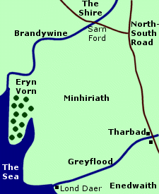 Region
of southern Eriador. Minhiriath was located
between the Brandywine River on its
northern border and the Greyflood on
its southern border. The Shire was north of the
Brandywine across Sarn Ford. The region called Enedwaith
was south of the Greyflood.
Region
of southern Eriador. Minhiriath was located
between the Brandywine River on its
northern border and the Greyflood on
its southern border. The Shire was north of the
Brandywine across Sarn Ford. The region called Enedwaith
was south of the Greyflood.
The eastern border of Minhiriath was probably around the North-South Road. On the west, Minhiriath had a coast on the Sea. The forest of Eryn Vorn was on a cape on the coast of Minhiriath.
The city of Tharbad was on the Greyflood on the border between Minhiriath and Enedwaith. The area around Tharbad was swampy. The port of Lond Daer was also on the Greyflood where it flowed into the Sea.
Minhiriath was originally covered with a vast forest. Many Men lived in scattered communities throughout the forest. These people were akin to the People of Haleth - one of the Three Houses of the Edain who migrated to Beleriand in the First Age and later gave rise to the Numenoreans.
In the Second Age, many trees in Minhiriath were cut down by Men from Numenor. The felling of trees was begun in the late 700s and the 800s by Aldarion, a mariner of Numenor who used the timber to build ships. The port of Lond Daer was established to receive timber from up the Greyflood.
As the devastation increased, the forest dwellers became hostile to the Numenoreans and attacked them and Lond Daer. The Numenoreans responded by cutting down even more trees without replanting any. They expanded their timber operations deep into Minhiriath and the native people fled to Eryn Vorn.
During the War of the Elves and Sauron from 1693 to 1701, many of the natives of Minhiriath sided with Sauron against the Numenoreans and the Elves. The natives acted as spies and guides for Sauron's troops. Many more trees were burned and destroyed as the war raged. Sauron was defeated and driven out of Eriador in 1701.
After the war, the majority of the woodlands were gone and most of Minhiriath became wide open grasslands. A few forested areas remained, most notably the forest of Eryn Vorn. Forest folk continued to live in Eryn Vorn but they had little contact with outsiders.
In 3320, the North-kingdom of Arnor was established by the survivors of the destruction of Numenor, who became known as the Dunedain. Minhiriath was within the boundaries of Arnor. After Arnor was divided into three Kingdoms in 861 of the Third Age, Minhiriath became part of Cardolan. The last prince of Cardolan was killed in battle against the forces of Angmar in 1409.
Many of the inhabitants of Minhiriath died during the Great Plague of 1636. The Dunedain of Cardolan were wiped out. In 2912, Minhiriath was devastated by floods in the spring thaw following the Fell Winter. Tharbad was ruined at this time.
After the War of the Ring at the end of the Third Age, the North-kingdom of Arnor was reestablished by Aragorn, King Elessar. Minhiriath and other regions of Eriador were repopulated during the Fourth Age.
Names &
Etymology:
The name Minhiriath means
"between the rivers" in Sindarin in reference to the Brandywine and Greyflood.
The word min means "between" and hiriath is from siriath
meaning "rivers."
Sources:
The Return
of the King: "Homeward Bound," p. 272-73
Appendix
A of The Lord of the Rings: "The North-kingdom and the Dunedain," p.
321
Appendix
B of The Lord of the Rings: "The Tale of Years," p. 370
Unfinished
Tales: "Aldarion and Erendis," p. 176, 180-81, 188; "The History of
Galadriel and Celeborn," p. 261-65; "The Hunt for the Ring," p. 341
The History
of Middle-earth, vol. XII, The Peoples of Middle-earth: "Of Dwarves
and Men," p. 313-14, 329 note 69, 330 note 72
The Lord
of the Rings: A Reader's Companion by Wayne G. Hammond and Christina
Scull: "Many Partings," p. 649-50; "Appendix A," p. 691
Nevrast |
Map
of Nevrast
|
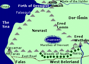 Sheltered
land on the west coast of Middle-earth. Nevrast was located between Hithlum
to the north northeast and West Beleriand to the south. There was disagreement
whether Nevrast was part of Hithlum or Beleriand.
Sheltered
land on the west coast of Middle-earth. Nevrast was located between Hithlum
to the north northeast and West Beleriand to the south. There was disagreement
whether Nevrast was part of Hithlum or Beleriand.
Nevrast was bordered on all sides by mountains, hills, and cliffs, and the land within sloped downward into a hollow. The Ered Lomin were on the eastern border of Nevrast. The region of Dor-lomin in Hithlum lay east of the mountains.
On the southern border of Nevrast, a range of hills extended westward from the Ered Wethrin to the Sea. Mount Taras stood on a cape at the western end of the range. Vinyamar, the hall of Turgon, was built on the slopes of Mount Taras overlooking the Sea.
From Vinyamar, a road ran south to Brithombar in the coastal region of the Falas. The East Road extended to Vinyamar along the southern feet of the outliers of the Ered Wethrin.
The coastline along Nevrast's western border was a wall of high cliffs. The clifftops were higher than the land behind them. (Note: HoME XI, p. 192, indicates that the cliffs are represented in the same way as hills on the map of Nevrast. It is unclear whether there was also a range of hills stretching from Mount Taras to the Ered Lomin.)
At the base of the cliffs there were many coves and inlets with beaches of white sand. The Elves carved stairs into the cliffs and built stone quays to moor their ships. The Firth of Drengist pierced the coastline north of Nevrast.
Nevrast had a mild climate. The mountains sheltered Nevrast from the cold north winds of Hithlum, and the land benefitted from sea-breezes and rain from the west.
Flowers and grass grew on the clifftops by the Sea, and woods grew farther inland. There were no rivers in Nevrast, but there was a large lake named Linaewen. The lake was surrounded by the Marshes of Nevrast. Many birds lived in Nevrast around Linaewen as well as along the seashore.
In ancient times, Ulmo, Lord of Waters, and his vassal Osse often came to the coast near Mount Taras. Many Sindarin Elves settled there and elsewhere in Nevrast sometime after they abandoned the Great Journey to the Undying Lands in 1150 of the Years of the Trees.
At the start of the First Age, a group of Noldor led by Turgon came to dwell in Nevrast. The Sindarin Elves of Nevrast welcomed Turgon as their lord, and the two groups of Elves mingled and intermarried. They built the halls of Vinyamar on Mount Taras, and they also made an underground passage called the Gate of the Noldor leading from the Firth of Drengist to Hithlum.
Ulmo sent Turgon a dream urging him to find a place to establish a realm hidden from Morgoth. With Ulmo's guidance, Turgon found the valley of Tumladen in the year 53. In 64, he sent workers to start building the city of Gondolin. Turgon remained in Vinyamar until the city was completed.
In 116, Turgon and his people left Nevrast and relocated to Gondolin. Ulmo instructed Turgon to leave arms behind in Vinyamar to be found by a messenger who would bring a warning to Gondolin in time of danger. For centuries afterwards, Nevrast was empty and desolate except for the birds.
After the Battle of Unnumbered Tears in 472, Hithlum was occupied by Easterlings. In 473, Morgoth sent an army through Hithlum and Nevrast to the Falas where they attacked and destroyed Brithombar and Eglarest.
In 495, a Man named Tuor escaped from Hithlum through the Gate of the Noldor. Tuor emerged into Cirith Ninniach, the Rainbow Cleft, and continued on to the Firth of Drengist. Then, guided by gulls, he climbed out of the ravine.
Tuor turned south and entered Nevrast. From a clifftop on the coast, he saw the Sea for the first time and was filled with yearning. Tuor stayed in Nevrast through the spring and summer. He journeyed inland to Linaewen but then he returned to the coast. He spent time exploring and he discovered the many staircases leading down to the coves along the coast.
In autumn, seven swans guided Tuor to Vinyamar where he found the arms left by Turgon. Ulmo appeared before him and told him to seek Gondolin. There was a great storm that night, and in the morning Tuor found an Elf named Voronwe who had been shipwrecked and washed ashore. Voronwe had been born in Nevrast and had moved to Gondolin with Turgon, and he agreed to guide Tuor there.
In Gondolin, Tuor married Turgon's daughter Idril. Their son Earendil later sailed to the Undying Lands to seek the help of the Valar, who defeated Morgoth in the War of Wrath at the end of the First Age. Nevrast and most of Beleriand were destroyed during the war.
Names &
Etymology:
The name Nevrast means "Hither
Shore" - or "near shore" - in Sindarin. The name originally applied to
the entire coast of northwestern Middle-earth south of the Firth of Drengist.
The coast of Aman in the Undying Lands was called Haerast, the Far
Shore.
Sources:
The Silmarillion:
"Of the Return of the Noldor," p. 113-15; "Of Beleriand and Its Realms,"
p. 119; "Of the Noldor in Beleriand," p. 125-26; "Of Maeglin," p. 131;
"Of the Fifth Battle," p. 196; "Of Tuor and the Fall of Gondolin," p. 238-39,
244; Index, entry for Nevrast
Unfinished
Tales: "Of Tuor and His Coming to Gondolin," p. 24-34, 41, 46, 48-49,
51, 52 note 6, 53 note 10 and 11, 54 note 21
The History
of Middle-earth, vol. XI, The War of the Jewels: "The Grey Annals,"
p. 35, 38, 40, 44-45, 80, 91, 120, 146; "The Later Quenta Silmarillion,"
p. 181, 182 (map), 186, 192-93, 197-200; "The Wanderings of Hurin," p.
256; "Quendi and Eldar," p. 396
Nisimaldar was sheltered from the north and was open to the Sea on the west. The weather was generally warm with abundant rainfall.
Nisimaldar was known for its evergreen and fragrant trees. The trees had been brought there by the Elves of the Undying Lands and included the oiolaire, lairelosse, nessamelda, vardarianna, taniquelasse, yavannamire, and malinorne. Nisimaldar was the only place in Numenor where the malinorne - or mallorn - grew. The air of Nisimaldar was filled with the sweet fragrance of its many trees.
Names &
Etymology:
The name Nísimaldar
means "Fragrant Trees" in Quenya from nísima meaning "fragrant"
and aldar meaning "trees."
Sources:
Unfinished
Tales: "A Description of the Island of Numenor," p. 167
Quenya-English
Wordlist
Noman-landsDesolate region north of the Black Gate of Mordor. The Noman-lands included arid, windswept moors and the barren, rocky Battle Plain of Dagorlad. West of the Noman-lands were the Dead Marshes and the Emyn Muil. The Brown Lands were to the north and Ithilien was to the south. Between the Noman-lands and the Black Gate was a stretch of wasteland called the Desolation of the Morannon.On March 2, 3019 of the Third Age, Frodo Baggins, Sam Gamgee, and Gollum emerged from the Dead Marshes and set out across the Noman-lands. They reached the Desolation of the Morannon on March 4. Names &
Etymology:
In the first edition of The Lord of the Rings the name was spelled Nomen's Land but was changed to Noman-lands. The Elvish name was Uvanwaith apparently meaning "no man's land." The word waith from gwaith means "people" but also denotes "region." The first element uvan is unclear. It appears to contain the negative prefix ú in the form of uv. The second part of the element could be anw meaning "man." Sources:
|
Map
showing the Noman-lands
 |
The great Sea of Nurnen - also called Lake Nurnen - was located in Nurn. The Sea of Nurnen was fed by four rivers that flowed through Nurn - two from the Mountains of Shadow and two from the spur of the Ash Mountains.
The land of Nurn was fertile compared to the rest of Mordor because of the lake and rivers and because it was far from the fumes of Mount Doom. Food for the peoples of Mordor was grown in Nurn by slaves.
After the War of the Ring, Aragorn, King Elessar, freed the slaves and gave the land of Nurn to them. The southern region of Nurn probably escaped the destruction caused in northern Mordor by the eruption of Mount Doom.
Note:
For a map of Nurn, see Mordor:
Map.
Names &
Etymology:
The name Nurn means "lament"
in Sindarin. Nurnen means "sad water."
Sources:
The Return
of the King: "The Land of Shadow," p. 201; "The Steward and the King,"
p. 247
Unfinished
Tales: Index entry for Nurnen (definition)
Book of
Lost Tales I: "Appendix - Names in the Lost Tales," entry for Nuri
(definition of nurn)
Ossiriand |
Map
of Ossiriand
|
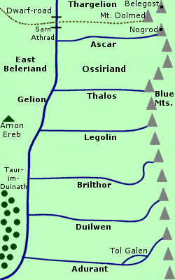 The
Land of Seven Rivers in Beleriand. Ossiriand was at the foot of the Blue
Mountains which formed its eastern border. The River
Gelion was its western border. Six tributaries of the Gelion flowed
from the mountains through Ossiriand: The Ascar
on the northern border, the Thalos, the Legolin,
the Brilthor, the Duilwen, and the Adurant
on the southern border.
The
Land of Seven Rivers in Beleriand. Ossiriand was at the foot of the Blue
Mountains which formed its eastern border. The River
Gelion was its western border. Six tributaries of the Gelion flowed
from the mountains through Ossiriand: The Ascar
on the northern border, the Thalos, the Legolin,
the Brilthor, the Duilwen, and the Adurant
on the southern border.
North of Ossiriand was the region of Thargelion. The Dwarf-road came down from the cities of Belegost and Nogrod in the Blue Mountains and ran along the northern bank of the Ascar, crossing the Gelion at Sarn Athrad. West of Ossiriand were the open lands of East Beleriand and the great woodland of Taur-im-Duinath.
Ossiriand was a peaceful region with forests of tall green elm trees. Treebeard sometimes walked there in the summertime. The land was protected by the power of Ulmo, Lord of Waters, which ran through the Gelion and its tributaries.
Ossiriand was settled by the Nandor. These Elves had tarried on the Great Journey westward, but a group of them finally came over the Blue Mountains in 1350 of the Years of the Trees led by Denethor. They were a woodland people who loved to live near running water, and they were the most knowledgable of all the Elves about plants and animals.
At the request of King Thingol of Doriath, Denethor led an army to the First Battle against Morgoth's forces in 1497, but they were poorly armed and many were slain. Denethor was surrounded on Amon Ereb and was killed. Thingol drove Morgoth's forces from East Beleriand.
After the battle, many of Denethor's people relocated to Doriath, but some returned to Ossiriand. The Elves of Ossiriand did not have another king after Denethor. They became a secretive and seculded people who avoided the conflicts between the Elves and Morgoth.
The Elves of Ossiriand became known as the Laiquendi, or Green-elves, because they wore green clothing that blended with the leaves of the trees. They were stealthy and could avoid being seen by strangers who entered their land. They did not light fires or cut down trees or hunt the animals that lived in the woods.
The Green-elves were highly skilled singers. They sang during the daytime and their music could be heard across the Gelion. Ossiriand also came to be called Lindon, the Land of Music.
In the year 20 of the First Age, Fingolfin, the High King of the Noldor, held the Feast of Reuniting and invited representatives from the different groups of Elves in Beleriand. A contingent of Green-elves attended the feast and took part in the counsels.
In 310, the Men of the House of Beor crossed the Blue Mountains and camped in a mountain valley in northern Ossiriand. They were discovered there by Finrod Felagund of Nargothrond who was visiting the region. The Green-elves were dismayed by the arrival of the newcomers and they sent messengers to Finrod requesting that he ask the Men to move on. The Men of the House of Beor crossed the Gelion and settled in Estolad.
Two more groups of Men followed. The Green-elves were unfriendly to the Haladin so they settled in Thargelion north of Ossiriand. The Green-elves hid from the People of Marach, who were strong and warlike, but these Men continued on into Estolad to join the People of Beor.
In the Battle of Sudden Flame in 455, Morgoth's forces invaded East Beleriand. Thargelion was overrun but the enemy forces did not enter Ossiriand. The Elves of Thargelion led by Caranthir fled south to Amon Ereb which stood across the Gelion from Ossiriand. Caranthir maintained a watchpost on Amon Ereb and the Green-elves of Ossiriand gave him aid. Some Sindarin Elves took refuge in Ossiriand at this time.
In 469, Beren and Luthien were returned to life from the Halls of Mandos and they came to dwell on Tol Galen, an island in the Adurant on the southern border of Ossiriand. The surrounding area came to be callled the Land of the Dead that Live. Their son Dior was born there in 470.
The Elves of Beleriand suffered a crushing defeat in the Battle of Unnumbered Tears in 472. Afterwards, Orcs and wolves roamed freely into Beleriand as far as Ossiriand though they did not cross its borders. The sons of Feanor were scattered and homeless and during their wanderings they stayed with the Green-elves of Ossiriand.
In 503, an army of Dwarves from Nogrod came down the Dwarf-road to attack Doriath following an altercation between Thingol and a company of Dwarf craftsmen that had resulted in the death of Thingol and many Dwarves. The Dwarf army plundered Doriath and stole many treasures including the Nauglamir set with one of the Silmarils.
As the army approached Sarn Athrad on the way back to Nogrod, Beren rallied the Green-elves to stop them. The Green-elves used their skills at camouflage to ambush the Dwarves. Most of the Dwarves were slain and the rest were dealt with by the Ents on the slopes of the Blue Mountains. The treasure was sunk to the bottom of the Ascar which became known as Rathloriel, the Goldenbed.
Beren kept the Nauglamir and gave it to Luthien. While she wore it, her beauty combined with the light of the Silmaril made the Land of the Dead that Live as fruitful and radiant as the Undying Lands. But shortly afterwards, Beren and Luthien died.
Dior had gone to Doriath to assume the kingship of his late grandfather Thingol. A lord of the Green-elves brought the Nauglamir to Dior after the death of his parents. The sons of Feanor attacked Doriath in 506 to try to claim the Silmaril made by their father. Dior was killed but his daughter Elwing was rescued along with the Silmaril. Dior's sons Elured and Elurin were abandoned to starve in the woods, but according to one story (HoME XI, p. 351) they were led by birds back to Ossiriand.
Most of Beleriand was destroyed in the War of Wrath at the end of the First Age. A part of Ossiriand remained west of the Blue Mountains. The Gelion and its tributaries were gone, and the Gulf of Lune divided the land. The land was called Lindon which had been an alternate name for Ossiriand.
Many of the Elves who remained in Middle-earth settled in Lindon under the leadership of Gil-galad, while Cirdan established the Grey Havens on the Gulf of Lune. Among them were Green-elves of Ossiriand. Some Green-elves were said to have accompanied Galadriel and Celeborn, who migrated eastward into Eriador early in the Second Age and settled on the shores of Lake Evendim before moving on to found Eregion.
Names &
Etymology:
The name Ossiriand means
"Land of Seven Rivers" in Sindarin from the stem of odog meaning
"seven" (odo in the Doriathrin dialect) and sîr meaning
"river" and the ending -and meaning "country, region." The name
refers to the Gelion and its six tributaries. Also called Ossir.
The Noldor called it Lindon meaning "Land of Music" because of the singing of the Green-elves. The name Lindon was later used for the remnant of Ossiriand after the destruction of Beleriand.
Sources:
The Two
Towers: "Treebeard," p. 72
The Silmarillion:
"Of the Sindar," p. 94, 96; "Of the Return of the Noldor," p. 113; "Of
Beleriand and Its Realms," p. 121-24; "Of the Coming of Men into the West,"
p. 140, 142-43; "Of the Ruin of Beleriand," p. 151, 153; "Of the Fifth
Battle," p. 188, 195; "Of the Ruin of Doriath," p. 234-36; "Of the Rings
of Power and the Third Age," p. 285-86; "Appendix - Elements in Quenya
and Sindarin Names," entry for sir
Unfinished
Tales: "Narn I Hin Hurin," p. 77; "The History of Galadriel and Celeborn,"
p. 234, 256
The History
of Middle-earth, vol. V, The Lost Road and Other Writings: "The Etymologies,"
entries for OT and SIR
The History
of Middle-earth, vol. X, Morgoth's Ring: "The Annals of Aman," p. 93,
104; "The Later Quenta Silmarillion," p. 164
The History
of Middle-earth, vol. XI, The War of the Jewels: "The Grey Annals,"
p. 13, 15-16, 22, 34, 39, 71, 80, 110-12; "The Later Quenta Silmarillion,"
p. 215-16, 218; "The Tale of Years" p. 351, 353; "Quendi and Eldar," p.
384-85
"The Rivers
and Beacon-hills of Gondor," by J.R.R. Tolkien, edited by Carl F. Hostetter,
commentary by Christopher Tolkien, in Vinyar Tengwar #42, July 2001,
p. 25
South Gondor |
Map
of South Gondor
|
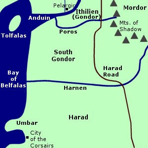 Contested
region between Gondor and Harad.
South Gondor was located on the east coast of the Bay
of Belfalas. It was bordered on the north by the Mouths of the Anduin
and the River Poros. The region of Gondor
called
Ithilien was north of the Poros.
Contested
region between Gondor and Harad.
South Gondor was located on the east coast of the Bay
of Belfalas. It was bordered on the north by the Mouths of the Anduin
and the River Poros. The region of Gondor
called
Ithilien was north of the Poros.
To the east were the Mountains of Shadow on the border of Mordor. The River Harnen was on South Gondor's eastern and southern border, beyond which was the land of Harad. The Harad Road passed through South Gondor.
Gondor apparently gained control of South Gondor in the time of the Ship-kings. Tarannon Falastur expanded Gondor's territory along the coasts of the Bay of Belfalas prior to becoming the first Ship-king in 830 of the Third Age. During the reign of the last Ship-king, Hyarmendacil I (1015-1149), Gondor included South Gondor with the Harnen as its southern border. Gondor also held the Havens of Umbar which was farther south along the coast in Harad.
In 1448, Umbar was captured by rebels of Gondor who had been defeated in the civil war of the Kin-strife. The rebels became known as the Corsairs and they intermingled with the Haradrim. South Gondor was no longer under Gondor's control but was instead disputed with the Corsairs and became deserted.
In 1944, the Haradrim came through South Gondor and invaded Ithilien as part of a joint attack with the Wainriders of Rhun. The Haradrim were defeated by Earnil and the Southern Army of Gondor. Earnil then defeated the Wainriders in the Battle of the Camp.
In 2885, South Gondor was occupied by the Haradrim and there was fighting along the Poros. The Haradrim tried to invade Ithilien, but they were defeated at the Crossings of Poros by the Men of Gondor led by Turin II and Gondor's allies the Rohirrim. Folcred and Fastred - the sons of King Folcwine of Rohan - were killed in battle and were buried in Haudh in Gwanur near the river crossing.
After the War of the Ring, Aragorn, King Elessar, made peace with the peoples of Harad though some remained enemies of Gondor. Gondor may have reestablished some form of control over South Gondor in the Fourth Age.
Names &
Etymology:
South Gondor was called Harondor
in Sindarin. The word har means "south."
Sources:
Appendix
A of The Lord of the Rings: "Gondor and the Heirs of Anarion," p. 324-25,
327; "The Stewards," p. 335
Map of Middle-earth
by Pauline Baynes
During the War of the Ring, Tookland was heavily guarded by the ruffians who occupied the Shire. The Tooks had set up defenses in their deep holes and had killed three Men who had trespassed on their land. The Men prevented anyone from entering or leaving Tookland after that, until Peregrin Took arrived on November 2, 3019 of the Third Age, to rally the Tooks. Peregrin's father Thain Paladin II then mustered his troops and drove off the Men guarding Tookland while Peregrin led a company of Tooks to the Battle of Bywater.
Sources:
The Fellowship
of the Ring: Map of "A Part of the Shire"; "Prologue: Concerning Hobbits,"
p. 15-16; "Prologue: Of the Ordering of the Shire," p. 18-19
The Return
of the King: "The Scouring of the Shire," 289, 294
The Lord
of the Rings: A Reader's Companion by Wayne G. Hammond and Christina
Scull: "Prologue," p. 33; "Three Is Company," p. 95
Many Hobbits moved to the Westmarch, including Sam Gamgee's daughter Elanor and her husband Fastred. They made their home at Undertowers on the Tower Hills and their descendants were known as the Fairbairns of the Towers. Fastred was made the first Warden of Westmarch by Thain Peregrin I in the year 34 of the Fourth Age. The Fairbairns continued to hold this title.
The book written by Bilbo and Frodo Baggins and Sam Gamgee chronicling the finding and the destruction of the One Ring was kept by the Fairbairns at Undertowers. This record came to be known as the Red Book of Westmarch. It was kept with Bilbo's three-volume Translations from the Elvish, and in Westmarch a fifth volume was added containing commentaries, genealogies, and other information about the Hobbit members of the Fellowship. Other historical books and records were also kept in the library at Undertowers.
*Note:
In some editions of The
Lord of the Rings, an incorrect date of 1462 S.R. (41 F.A.)
is given in the Prologue.
Names &
Etymology:
March means "borderland."
Sources:
The Fellowship
of the Ring: "Prologue: Of the Ordering of the Shire," p. 18; "Prologue:
Note on the Shire Records," p. 23
Appendix
B of The Lord of the Rings: "The Tale of Years," p. 378
The Lord
of the Rings: A Reader's Companion by Wayne G. Hammond and Christina
Scull: "Prologue," p. 32-33 (explanation of date discrepancy)
All entries are Copyright © by the Thain from former tuckborough.net. Please contact me if you are Thain or know anything about how to contact the original author.
2003-2012, The Thain's Book - thainsbook.minastirith.cz
- e-mail: thain at tuckborough.net