

An encyclopedia of Middle-earth and Numenor
|
|
|
|
|
|
|
|
|
|
|
|
|
|
| |
|
|
An encyclopedia of Middle-earth and Numenor |
|

Andrast was inhabited by Men called the Druedain. The Druedain had at one time lived throughout the White Mountains, but they were driven out by evil Men. By the time Gondor was founded at the end of the Second Age, the Druedain survived only in the Druadan Forest and in the mountainous region called Druwaith Iaur which included Andrast.
Andrast was not part of Gondor. It lay west of the River Lefnui, which was the western border of Gondor. The Men of Gondor never made settlements in Andrast, though they maintained a coast guard and beacons at the far end of the cape.
Names &
Etymology:
Andrast means "long cape."
The element and means "long." The element rast means "cape"
from ras meaning "horn." A cape is a point of land extending
into water.
Andrast was also called Ras Morthil. The word morthil may mean "dark peaks" from mor meaning "black, dark" and thil from til meaning "point, peak." This may be a reference to the mountains on Andrast.
Sources:
Map of Middle-earth
by Pauline Baynes
Unfinished
Tales: "Aldarion and Erendis," p. 175, 214 note 6; "The History of
Galadriel and Celeborn," p. 261, 263; "The Druedain," p. 383-84, 387 note
13
The Silmarillion:
"Appendix - Elements in Quenya and Sindarin Names," entries for an(d),
mor, ras, and til
The History
of Middle-earth, vol. V, The Lost Road and Other Writings: "The Etymologies,"
entries for RAS and TIL
"The Rivers
and Beacon-hills of Gondor," by J.R.R. Tolkien, edited by Carl F. Hostetter,
commentary by Christopher Tolkien, in Vinyar Tengwar #42, July 2001,
p. 14
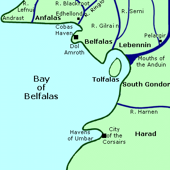
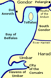
Bay of Belfalas |
Map
of the Bay of Belfalas
|
 Bay
on the southern coast of Gondor. The Bay of Belfalas
was very large and opened onto the Sea. It was an important inlet for seafaring
ships.
Bay
on the southern coast of Gondor. The Bay of Belfalas
was very large and opened onto the Sea. It was an important inlet for seafaring
ships.
The northwestern arm of the Bay of Belfalas was a long cape called Andrast. The lands of Anfalas and Belfalas were along the northern coast of the bay. Dol Amroth was the chief city of Belfalas and was an important port. It was built on a high promontory overlooking an inlet of the Bay of Belfalas called Cobas Haven.
Just north of Dol Amroth was the Elf-haven of Edhellond, at the mouth of the Blackroot River. A community of Elves lived at Edhellond from around the end of the First Age to the middle of the Third Age, and from there ships set sail to the Undying Lands. According to legend, the Elf-lord Amroth awaited his lover Nimrodel in a ship at Edhellond, but she became lost and never arrived. Amroth's ship was swept away from the shore by a storm and he leaped overboard into the Bay of Belfalas and was lost.
The Mouths of the Anduin opened onto the bay on its eastern coast. The island of Tolfalas was in the northeastern corner of the bay at the Mouths of the Anduin.
In addition to the Anduin, a number of rivers flowed into the Bay of Belfalas. On the northwest coast, the River Lefnui flowed south from the White Mountains into the bay. The rivers Blackroot, Ciril, and Ringlo also began in the White Mountains and merged before flowing into the bay near Dol Amroth. The River Gilrain was joined by the River Serni and emptied into the bay just north of the Anduin. On the east coast of the bay, the River Harnen flowed into the bay from the Mountains of Shadow.
South of the Anduin on the east coast of the bay was the region called South Gondor. Further south was the coastal region of Umbar in Harad. The Havens of Umbar were established there by the Men of Numenor in the Second Age. For much of the Third Age, the Corsairs used Umbar as a base of operations, and the city at the head of the inlet was called the City of the Corsairs.
Names &
Etymology:
The meaning of Belfalas is
uncertain. The word falas means "shore, coast" in Sindarin. In his
unfinished Index to The Lord of the Rings,
Tolkien defined the word bel as "steep, sheer" in Sindarin.
(Reader's
Companion, p. 18)
But in a later essay he wrote that Bêl was the name of the region in the language of the original inhabitants and that it meant "shore, coast" so that Belfalas was a combination of two words with the same meaning in different languages. ("Rivers & Beacon-hills," p. 15-16)
Also called Côf Belfalas, where côf means "bay" in Sindarin, and Côf gwaeren Bel, "the windy Bay of Bêl."
Sources:
Map of
Middle-earth by J.R.R. Tolkien
The Fellowship
of the Ring: "Lothlorien," p. 354-55; "The Great River," p. 397
The Return
of the King: "Minas Tirith," p. 38; "The Last Debate," p. 152
Appendix
A of The Lord of the Rings: "Gondor and the Heirs of Anarion," p. 325,
327-29; "The Stewards," p. 334, 335
Appendix
B of The Lord of the Rings: "The Tale of Years," p. 378
Unfinished
Tales: "Aldarion and Erendis," p. 175, 214 note 6; "The History of
Galadriel and Celeborn," p. 242-43, 245, 246-48
The History
of Middle-earth, vol. V, The Lost Road and Other Writings: "The Etymologies,"
entries for BEL and PHAL, PHALAS
The History
of Middle-earth, vol. VII, The Treason of Isengard: "The First Map,"
p. 312, 322 note 10 (Cobas Haven)
The Atlas
of Middle-earth by Karen Wynn Fonstad: Map of the White Mountains,
p. 88-89
"The Rivers
and Beacon-hills of Gondor," by J.R.R. Tolkien, edited by Carl F. Hostetter,
commentary by Christopher Tolkien, in Vinyar Tengwar #42, July 2001,
p. 15-16
The Lord
of the Rings: A Reader's Companion by Wayne G. Hammond and Christina
Scull: "Prologue," p. 18-19
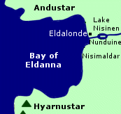
Bay of EldannaBay on the west coast of Numenor. The Bay of Eldanna was a large inlet between the promontories of Andustar to the north and Hyarnustar to the south. The bay faced west toward the Undying Lands and the ships of the Elves often came there.The haven of Eldalonde was on the east side of the bay at the mouth of the Nunduine. Eldalonde was in the coastal region called Nisimaldar which was known for its fragrant trees. The lands around the Bay of Eldanna were sheltered from the north and the climate was warm and frequently rainy. Names &
Etymology:
Sources:
|
Map
of the Bay of Eldanna
 |
Fisherfolk originally lived around Cobas Haven, but they relocated to the White Mountains after Elves established the haven of Edhellond near the mouth of the Blackroot. Elves lived at Edhellond during the Second Age and the first half of the Third Age, and Elven-ships set sail from there to the Undying Lands. The last Elves departed from Edhellond in 1981 of the Third Age.
Names &
Etymology:
The word Cobas means "haven,
harbor, bay" from the Quenya kópa or its variant form hópa
(Sindarin = hobas).
Sources:
The Book
of Lost Tales, Part One: "Appendix - Names in The Lost Tales - Part
One," p. 257
The History
of Middle-earth, vol. V, The Lost Road and Other Writings: "The Etymologies,"
entries for KHOP and KOP
The History
of Middle-earth, vol. VII, The Treason of Isengard: "The First Map,"
p. 312, 322 note 10
Unfinished
Tales: "The History of Galadriel and Celeborn," p. 247
Firth of Drengist |
Map
of the Firth of Drengist
|
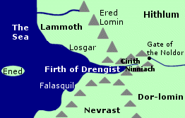 Inlet
on the west coast of Middle-earth where Feanor landed. The Firth of Drengist
was located on the border of
Hithlum in Beleriand.
The mouth of the firth opened onto the Sea. The island of Ened was in the
Sea west of the firth.
Inlet
on the west coast of Middle-earth where Feanor landed. The Firth of Drengist
was located on the border of
Hithlum in Beleriand.
The mouth of the firth opened onto the Sea. The island of Ened was in the
Sea west of the firth.
On the southern shore of the firth there was a small cove called Falasquil. South of the firth was the land of Nevrast. On the northern shore of the Firth of Drengist was a place called Losgar. The region to the north between the Ered Lomin and the Sea was called Lammoth.
As the Firth of Drengist stretched inland it breached the Ered Lomin - the mountain range that formed the western border of Hithlum. At the eastern end of the firth was a narrow ravine called Cirith Ninniach, the Rainbow Cleft.
A river came from a tunnel beneath the Ered Lomin and flowed through the ravine into the firth. Waterfalls fed the river from the hills near its juncture with the firth, but then the walls of the ravine became sheer cliffs. There was a path along a strand on the southern side of the river.
The river came from the region of Dor-lomin in Hithlum. On the eastern side of the mountains, there was an arched entrance to the tunnel called Annon-in-Gelydh, the Gate of the Noldor. The river formed rapids as it descended a slope from the Gate to a domed subterranean chamber. The river then went over a steep waterfall before continuing through another archway into the tunnel. Stairs were hewn alongside the falls.
In 1495 of the Years of the Trees, Morgoth stole the Silmarils and fled to Middle-earth. He crossed the Grinding Ice and came to the land north of the Firth of Drengist followed by his cohort Ungoliant, an evil being in the form of a Great Spider. Ungoliant wanted to devour the Silmarils and she cast a web around Morgoth, who let out a cry that echoed in the mountains. Afterwards the mountains were called Ered Lomin, the Echoing Mountains, and the region was named Lammoth, the Great Echo. Morgoth was rescued from Ungoliant by Balrogs from Angband.
In 1497, Feanor came to Middle-earth to reclaim the Silmarils he had made. He and his followers crossed the Sea in ships and landed at Losgar on the north shore of the Firth of Drengist. Feanor had abandoned his half-brother Fingolfin and many others back in the Undying Lands because there were not enough ships for all of them. Instead of sending the ships back for those left behind, Feanor ordered the ships to be burned.
The cries of Feanor's followers echoed in the mountains, and the flames of the burning could be seen by Fingolfin's people across the Sea. Morgoth's spies also became aware of Feanor's arrival. Feanor and his people journeyed up the Firth of Drengist and entered Hithlum. Morgoth sent an army to attack them, but the Elves were victorious in the Battle-under-Stars though Feanor was killed afterwards.
Fingolfin and his people crossed the Grinding Ice. They arrived in Middle-earth at the start of the First Age and traveled south through Lammoth to the Firth of Drengist and then entered Hithlum. Many of the Noldor settled in Hithlum with Fingolfin as High King.
Fingolfin's younger son Turgon went to live in Nevrast. It was said that Turgon's people built the Gate of the Noldor, though some sort of passage from the Firth of Drengist through the Ered Lomin must have existed previously since the Noldor first entered Hithlum that way.
In 155 of the First Age, Morgoth sent Orcs from Angband south through Lammoth to attack Hithlum from the Firth of Drengist. Fingolfin's elder son Fingon ambushed the Orcs from the hills at the head of the firth and drove most of them into the Sea.
In 462, another army from Angband attacked Hithlum, this time from the north and east. Cirdan brought a fleet of ships from the Havens of the Falas to the Firth of Drengist and drove out the Orcs.
After Morgoth's victory in the Battle of Unnumbered Tears in 472, Hithlum was occupied by Easterlings. A small number of Elves remained in Mithrim. Their leader was Annael whose foster-son Tuor was of the race of Men. In 488, Annael and his people escaped from Hithlum through the Gate of the Noldor and went to the Havens of Sirion, but Tuor was captured by the Easterling chieftain Lorgan.
Tuor escaped from Lorgan in 491 and lived for a time in the Caves of Androth. In 495, Ulmo, Lord of Waters, caused a spring near the caves to overflow and lead Tuor to the stream that flowed to the Gate of the Noldor. At first, Tuor did not see the entrance to the tunnel, but then two Elves named Gelmir and Arminas emerged from the Gate and showed him the way.
Tuor descended the stairs and passed through the tunnel and came out on the other side into the ravine. He gave the ravine the name Cirith Ninniach, the Rainbow Cleft, because of the many rainbows on the waters. Tuor journeyed through the ravine for five days before coming to the place where the river joined with the waters of the firth in a flood tide. He then turned southwards away from the firth into Nevrast and later found the hidden realm of Gondolin.
Names &
Etymology:
The meaning of Drengist is
unknown. In one source (HoME IV, p. 210),
Tolkien equated Drengist with the Old English word Nearufléot
meaning "narrow firth" from nearu meaning "narrow" and fléot
meaning "arm of the sea, estuary, firth." This is not necessarily intended
as a direct translation of the Elvish name.
Sources:
The Silmarillion:
"Of the Coming of the Elves," p. 54; "Of the Flight of the Noldor," p.
80, 89-90; "Of the Sindar," p. 97; "Of the Return of the Noldor," p. 106,
116; "Of Beleriand and Its Realms," p. 119; "Of the Ruin of Beleriand,"
p. 160; "Of Tuor and the Fall of Gondolin," p. 238
Unfinished
Tales: "Of Tuor and His Coming to Gondolin," p. 18-25, 51 note 3; "Narn
I Hin Hurin," p. 160, 162
The History
of Middle-earth, vol. IV, The Shaping of Middle-earth: "The Quenta,"
p. 210
The History
of Middle-earth, vol. X, Morgoth's Ring: "The Annals of Aman," p. 119-20
The History
of Middle-earth, vol. XI, The War of the Jewels: "The Grey Annals,"
p. 16-17, 46, 60, 89; "The Later Quenta Silmarillion," p. 181, 182 (map)
Grinding Ice |
Map
of the Grinding Ice
|
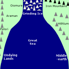 Icy
strait between the Undying Lands and Middle-earth. The Grinding Ice, or
Helcaraxe, was a narrow passage in the far north of the Great Sea where
the two landmasses curved toward each other. North of the Grinding Ice
was the Encircling Sea that encompassed the world.
Icy
strait between the Undying Lands and Middle-earth. The Grinding Ice, or
Helcaraxe, was a narrow passage in the far north of the Great Sea where
the two landmasses curved toward each other. North of the Grinding Ice
was the Encircling Sea that encompassed the world.
The strait was filled with icebergs that the rough seas caused to heave and grind against each other. The air was foggy and it was bitterly cold.
In the Undying Lands on the west side of the strait was the barren coastland of Araman between the Mountains of the Pelori and the Sea. The misty region called Oiomure was on the shore near the Grinding Ice.
In Middle-earth on the east side of the strait were the cold northern lands where Morgoth had his realm. South of Morgoth's realm was Hithlum, bordered by the Ered Lomin and the Ered Wethrin.
The Great Sea was widened during the Battle of the Powers between the Valar and Morgoth from 1090 to 1099 of the Years of the Trees. Afterwards, the strait of the Grinding Ice was the narrowest point between the continents of Aman and Middle-earth. The ice and cold were the result of the workings of Morgoth.
Morgoth and Ungoliant crossed the Grinding Ice in 1495 when they fled to Middle-earth after stealing the Silmarils. Feanor led the Noldor to reclaim the Silmarils, but he abandoned many of his kindred when there were not enough ships to carry them all to Middle-earth. Those who had been left behind continued northward, and around 1500 they set out on foot across the Grinding Ice.
Among the Elves who made the arduous trek across the ice were Fingolfin, Fingon, Turgon, Idril,Aredhel, Finrod, Orodreth, Angrod, Aegnor, and Galadriel. During the crossing, Turgon's wife Elenwe and daughter Idril fell into the icy waters. Turgon was able to save Idril, but Elenwe perished. Many other Elves also died on the journey.
The survivors arrived in Middle-earth when the Moon first rose at the start of the First Age. They had become stronger and more inured to hardship, and the crossing of the Grinding Ice was considered one of the greatest feats of the Noldor.
Names &
Etymology:
The Grinding Ice was named
for the icebergs moving against each other in the rough waters. The Quenya
name was Helcaraxë, composed of helca meaning "ice,
icy cold" and caraxë meaning "jagged hedge of spikes." Called
the Narrow Ice in a poem by Bilbo Baggins.
Sources:
The Silmarillion:
"Of the Coming of the Elves," p. 51; "Of Eldamar," p. 57; "Of the Flight
of the Noldor," p. 80, 89-90; Of the Return of the Noldor," p. 108, 116;
"Of the Noldor in Beleriand," p. 129; "Of Maeglin," p. 134
The Fellowship
of the Ring: "Many Meetings," p. 246
The History
of Middle-earth, vol. IV, The Shaping of Middle-earth: "The Ambarkanta,"
p. 249 (Map IV), 251 (Map V)
The History
of Middle-earth, vol. V, The Lost Road and Other Writings: "The Etymologies,"
entries for KARAK and KHEL
The History
of Middle-earth, vol. X, Morgoth's Ring: "The Annals of Aman," p. 75,
108, 118-20, 128
The History
of Middle-earth, vol. XI, The War of the Jewels: "The Grey Annals,"
p. 6, 29-30
The History
of Middle-earth, vol. XII, The Peoples of Middle-earth: "The Shibboleth
of Feanor," p. 345-46
Gulf of Lune |
Map
of the Gulf of Lune
|
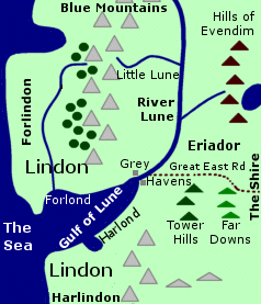 Gulf
where the Grey Havens were located.
The Gulf of Lune was located on the northwestern coast of Middle-earth.
The Elvish lands of Lindon and the range
of the Blue Mountains were divided by
the Gulf. The Gulf of Lune opened onto the Sea.
Gulf
where the Grey Havens were located.
The Gulf of Lune was located on the northwestern coast of Middle-earth.
The Elvish lands of Lindon and the range
of the Blue Mountains were divided by
the Gulf. The Gulf of Lune opened onto the Sea.
The River Lune flowed down from the Blue Mountains into the Gulf of Lune. The Grey Havens were located at the mouth of the river on the east shore of the Gulf. There was an inlet on the northern shore of the Gulf of Lune called Forlond and one on the southern shore called Harlond.
The Gulf of Lune was formed at the end of the First Age when the region of Beleriand was destroyed in the War of Wrath against Morgoth. The Blue Mountains were split by the new gulf and the River Lune changed its course to empty into it. The Grey Havens were founded by the Elves in the year 1 of the Second Age. Their leader was Cirdan the Shipwright.
The harborage in the Gulf of Lune held many ships. The Gulf was mainly used by the ships of the Elves that embarked from the Grey Havens to the Undying Lands. However, the ships of Men also came to the Gulf of Lune.
During the Second Age, ships came from Numenor to the Gulf of Lune starting with the voyage of Veantur in 600. A fleet from Numenor led by Admiral Ciryatur came to the Gulf of Lune in 1700 to help the Elves defeat Sauron in the War of the Elves and Sauron. In 3320 after the destruction of Numenor, Elendil sailed to the Gulf of Lune and founded the North-kingdom of Arnor in Eriador.
In 1975 of the Third Age, a great fleet arrived from Gondor to help fight the forces of the Witch-king of Angmar. There were so many ships that there was hardly room for them all in the Gulf of Lune. The combined forces of the Elves and the Men of Gondor defeated the Witch-king in the Battle of Fornost and drove him from the North.
As the Third Age came to an end, many Elves set sail from the Grey Havens as they left Middle-earth for the Undying Lands. On September 29, 3021, a ship embarked bearing Gandalf, Elrond, Galadriel, and the Hobbits Bilbo and Frodo Baggins. Mortals were not normally allowed to sail to the Undying Lands, but because of the great burden of bearing the One Ring, Frodo and Bilbo were given special permission.
Sam Gamgee followed Frodo to the Undying Lands from the Grey Havens in the year 61 of the Fourth Age. It is said that Cirdan remained at the Grey Havens until the Last Ship set sail into the West, but when that was is not known.
Names &
Etymology:
The Gulf of Lune is also
written as the Gulf of Lhûn. Lune is a Common Speech adaptation
of
lhûn - an earlier version of the Sindarin word luin
meaning "blue." The Gulf of Lune was fed by the River Lune which sprang
from the Blue Mountains.
The inlets on the north and south sides of the Gulf of Lune were called Forlond - "North Haven" from for meaning "north" and lond meaning "haven" - and Harlond - "South Haven" from har meaning "south."
Sources:
The Fellowship
of the Ring: "Prologue: Concerning Hobbits," p. 16; "Note on the Shire
Records," p. 25; "The Shadow of the Past," p. 52-54; "The Council of Elrond,"
p. 253, 279-80; "The Ring Goes South," p. 297; "Lothlorien," p. 363
The Return
of the King: "The Last Debate," p. 150; "Many Partings," p. 252-53;
"The Grey Havens," passim
Appendix
A of The Lord of the Rings: "The Numenorean Kings" p. 314-15; "Eriador,
Arnor, and the Heirs of Isildur," p. 319-20; "The North-kingdom and the
Dunedain," p. 322, 323; "Gondor and the Heirs of Anarion," p. 331; "The
Tale of Aragorn and Arwen," p. 344
Appendix
B of The Lord of the Rings: "The Tale of Years," p. 364, 364-65, 377-78
The Silmarillion:
"Of the Rings of Power and the Third Age," p. 285-86, 289, 298-99, 304;
"Appendix - Elements in Quenya and Sindarin Names," entries for formen,
hyarmen, and luin
Unfinished
Tales: "A Description of Numenor," p. 171; "Aldarion and Erendis,"
p. 174-75, 213 note 3; "The History of Galadriel and Celeborn," p. 239
The quays and landings of the Harlond were used by boats that came upriver to Minas Tirith from the southern provinces of Gondor. The Harlond was also a base for the King's Ships.
During the Battle of the Pelennor Fields on March 15, 3019 of the Third Age, Aragorn brought reinforcements to the Harlond on ships captured from the Corsairs.
Names &
Etymology:
The name Harlond means "South
Haven" from har meaning "south" and lond meaning "haven."
There was also an inlet on the Gulf of Lune
named Harlond.
Sources:
The Return
of the King: "Minas Tirith," p. 22; "The Battle of the Pelennor Fields,"
p. 123
The Silmarillion:
"Appendix - Elements in Quenya and Sindarin Names," entries for hyarmen
and londe
The History
of Middle-earth, vol. XII, The Peoples of Middle-earth: "The New Shadow,"
p. 421
Icebay of Forochel & Cape of Forochel |
Map
of the Icebay of Forochel
|
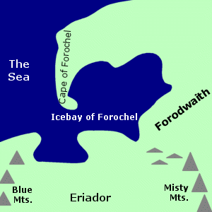 Bay
and cape in the far north of Middle-earth. The Icebay of Forochel was on
the northwestern coast, opening onto the Sea. South of the Icebay was Eriador,
and to the east was the northern wasteland of Forodwaith.
A long strip of land called the Cape of Forochel projected into the bay
on the northwestern side, making the entrance to the bay relatively narrow.
Bay
and cape in the far north of Middle-earth. The Icebay of Forochel was on
the northwestern coast, opening onto the Sea. South of the Icebay was Eriador,
and to the east was the northern wasteland of Forodwaith.
A long strip of land called the Cape of Forochel projected into the bay
on the northwestern side, making the entrance to the bay relatively narrow.
There were no ports on the Icebay of Forochel, and it was rarely used by ships. As its name suggests, the Icebay was in a cold climate and the waters froze during the winter months. A people called the Snowmen, or Lossoth, lived on the shores of the bay, particularly on the Cape of Forochel, though they also camped on the southern shore near the Blue Mountains. The Snowmen built homes out of ice and snow and used sleds and skis for transportation.
In 1975 of the Third Age, King Arvedui of Arthedain fled to the shores of the Icebay to escape the Witch-king of Angmar. The Snowmen gave Arvedui and his men food and shelter. Cirdan of the Grey Havens sent a ship to rescue Arvedui in March, but the bay was still frozen far out from the shore. The leader of the Snowmen advised Arvedui to wait for the spring thaw, but Arvedui did not heed his advice. The Snowmen pulled Arvedui and his men across the ice in their sleds and a boat from the ship picked them up.
Before the ship exited the Icebay, a great blizzard came and drove the ship back against the ice. The hull was crushed and the ship sank. Everyone aboard was killed. Arvedui had been carrying two of the palantiri - the Stone of Annuminas and the Stone of Amon Sul - and they sank to the bottom of the bay and were lost forever.
Names &
Etymology:
Forochel means "northern
ice" from for meaning "north" and
heleg meaning "ice." The
Icebay was also called the Bay of Forochel. A cape is a point
of land extending into water.
Sources:
Appendix
A of The Lord of the Rings: "The North-kingdom and the Dunedain," p.
321-22 and note 1
Unfinished
Tales: "Introduction," p. 13
The Silmarillion:
"Appendix
- Elements in Quenya and Sindarin Names," entry for formen
The History
of Middle-earth, vol. V, The Lost Road and Other Writings: "The Etymologies,"
entry for KHEL / KHELEK
The History
of Middle-earth, vol. VII, The Treason of Isengard: "The First Map,"
p. 301 and maps I and IA
Umbar |
Map
of Umbar
|
 Haven
and coastal region in Harad. Umbar was on the
coast of the Sea south of the Bay of Belfalas.
The natural harbor was almost completely enclosed on its north and west
sides by a long cape. The Men of Numenor built
a great fortress at Umbar, and later the City
of the Corsairs stood at the far end of the harbor.
Haven
and coastal region in Harad. Umbar was on the
coast of the Sea south of the Bay of Belfalas.
The natural harbor was almost completely enclosed on its north and west
sides by a long cape. The Men of Numenor built
a great fortress at Umbar, and later the City
of the Corsairs stood at the far end of the harbor.
The Numenoreans established a haven at Umbar in 2280 of the Second Age. It was used as a base by the King's Men - Numenoreans who had become estranged from the Elves and the Valar and who sought to expand their domains into Middle-earth. They oppressed the native inhabitants of Harad and demanded tribute from them.
Ar-Pharazon of Numenor landed at Umbar with a great fleet in 3261 of the Second Age. The people who lived near the coast fled before Ar-Pharazon as he marched north to confront Sauron. Sauron surrendered to Ar-Pharazon and allowed himself to be taken to Numenor. He later persuaded Ar-Pharazon to attack the Undying Lands, resulting in the destruction of Numenor in 3319.
The Numenoreans who lived in Umbar survived the Downfall. They were corrupted by Sauron and became known as the Black Numenoreans. Over time they intermarried with the Haradrim. Another group of survivors were the Faithful who had resisted Sauron. They founded the realms of Gondor and Arnor. The descendants of the Black Numenoreans and the descendants of the Faithful were enemies throughout the Third Age.
In 933 of the Third Age, King Earnil I of Gondor besieged Umbar by land and sea. He captured the Havens at great cost and drove away the lords of Umbar. Umbar became an important port of Gondor. Earnil perished at Sea in a storm off Umbar in 936.
At some point, the Men of Gondor built a tall white pillar topped with a crystal globe on a high hill on the headland overlooking the Havens of Umbar. The globe caught the light of the Sun and Moon and could been seen from far out at Sea. The pillar commemorated the landing of Ar-Pharazon who had humbled Sauron even though he had afterwards been corrupted by him. The pillar was later destroyed when Umbar fell into the hands of Men loyal to Sauron.
The lords of Umbar led the Haradrim in an attempt to retake the Havens in 1015. King Ciryandil of Gondor was killed, but Gondor's navy prevented the capture of Umbar. The siege lasted 35 years. In 1050, King Ciryaher led a force from the north by land and sea and broke the siege of Umbar. The Haradrim were subjugated and Gondor's territory extended south through Harad as far as Umbar. Ciryaher took the name Hyarmendacil, meaning "South-victor."
During the civil war of the Kin-strife in Gondor, the people of Umbar supported the rebel leader Castamir. In 1448, after the rightful king Eldacar killed Castamir the Usurper, Castamir's sons and their followers escaped to Umbar. They claimed the Havens as a stronghold for the enemies of Gondor.
The rebels merged with the inhabitants of Umbar. They took to the seas as Corsairs and raided Gondor's coasts and attacked its ships. The region called South Gondor that lay between Umbar and Ithilien was contested between the Corsairs and Gondor.
In 1540, the Corsairs of Umbar and the kings of Harad joined forces in battle against Gondor and King Aldamir of Gondor was killed. Aldamir's son retaliated against Umbar and Harad in 1551 and called himself Hyarmendacil II. In 1634, the Corsairs led by Angamaite and Sangahyando sacked Pelargir and killed King Minardil of Gondor.
The Corsairs continued to raid the coasts of Gondor as far as Anfalas. In 1810, King Telumehtar of Gondor attacked Umbar and destroyed the stronghold of the Corsairs. The last descendants of Castamir were killed. Umbar was briefly held by Gondor, but in the troubled years that followed Gondor was unable to maintain control of the Havens.
Umbar once again became a base for the Corsairs. In 2746, the Corsairs killed the Prince of Dol Amroth. Three fleets from Umbar and Harad attacked the coasts of Gondor in 2758. They put troops ashore as far north as the Isen and aided the Men of Dunland in their invasion of Rohan. Frealaf of Rohan defeated the Dunlendings, and Beregond of Gondor drove the Corsairs back from the coasts.
The Corsairs of Umbar joined the forces of Sauron who returned to his realm in Mordor in 2942. Aragorn recognized the threat posed to Gondor by the Corsairs while he was in the service of Ecthelion, the Steward of Gondor. In 2980, Aragorn launched a surprise attack on Umbar and burned many of their ships and killed the Captain of the Haven.
During the War of the Ring, the Corsairs captured Pelargir with a fleet of 50 large ships and a number of smaller ships. Farther down the coast at Linhir, forces from Umbar and Harad fought with Angbor and the Men of Lamedon. These attacks prevented many of Gondor's southern forces from strengthening the defenses of Minas Tirith.
Aragorn summoned an army from the Paths of the Dead to fight the Corsairs. As the Dead came to Linhir, the Men of Umbar and Harad retreated before them. At Pelargir on March 13, 3019, the Dead boarded the Corsairs' ships and the mariners jumped overboard in terror. Aragorn freed the slaves who were chained to the oars, many of whom were Men of Gondor who had been captured by the Corsairs.
Aragorn sailed the ships of the Corsairs to Minas Tirith. Denethor, the Steward of Gondor, saw the fleet approaching via the palantir and killed himself in despair thinking Gondor's doom was at hand. Aragorn's arrival on March 15 turned the tide of the Battle of the Pelennor Fields and Sauron's army was defeated. Sauron himself perished when the One Ring was destroyed on March 25.
After the war, Aragorn became King of the Reunited Kingdom of Gondor and Arnor. He made peace with the peoples of Harad and the Corsairs of Umbar were subdued.
Names &
Etymology:
The name Umbar was of forgotten
origin from before the arrival of the Numenoreans, and its meaning is not
known. Any relation to the Quenya word umbar meaning "fate" appears
to be coincidental. Also called the Haven of Umbar or Havens
of Umbar.
Sources:
Map of
Middle-earth by Pauline Baynes
The Two
Towers: "Of Herbs and Stewed Rabbit," p. 267
The Return
of the King: "Minas Tirith," p. 38; "The Passing of the Grey Company,"
p. 54; "The Battle of the Pelennor Fields," p. 122; "The Last Debate,"
p. 151-52
Appendix
A of The Lord of the Rings: "The Numenorean Kings," p. 317; "Gondor
and the Heirs of Anarion," p. 325 and note 1, 327-29, 332; "The Stewards,"
p. 333-35; "The House of Eorl," p. 347
Appendix
B of The Lord of the Rings: "The Tale of Years," p. 364, 366-67, 369
Appendix
E of The Lord of the Rings: "Writing and Spelling," p. 401
Appendix
F of The Lord of the Rings: "The Languages and Peoples of the Third
Age," p. 405, 407
The Silmarillion:
"Akallabeth," p. 266-67, 270
Unfinished
Tales: "The History of Galadriel and Celeborn," p. 242; "Cirion and
Eorl," p. 296, 312 notes 9 and 14; "The Istari," p. 398, 402 note 7
The History
of Middle-earth, vol. XII, The Peoples of Middle-earth: "The History
of the Akallabeth," p. 153, 155-56; "The Heirs of Elendil," p. 197-200,
205, 214, 222
Cair Andros was fortified during the time of Turin II - who ruled from 2882 to 2914 of the Third Age - in order to prevent Enemy forces from crossing the river there. The defenses of Cair Andros were maintained when the War of the Ring began, and horses were kept on the western side for the use of the Rangers of Ithilien.
On March 10, 3019, the defenses of Cair Andros were overrun by an army from the Black Gate consisting of battalions of Orcs and companies of Men from Rhun. They used the island to launch an attack on Anorien, threatening Minas Tirith from the north and blocking the Great West Road in an attempt to prevent the Riders of Rohan from coming to the aid of Gondor.
After the Battle of the Pelennor Fields, Aragorn took pity on the men who were too afraid to march to the Black Gate. He sent them to retake Cair Andros from the Enemy and hold it in defense of Gondor and Rohan.
Names &
Etymology:
Cair Andros means "ship of
long foam," in reference to the island's shape and the foamy waters that
broke on its northern end. The word cair means "ship." The element
and
means "long" and ros means "foam, spray."
Sources:
The Return
of the King: "The Siege of Gondor," p. 85, 89-90, 92; "The Black Gate
Opens," p. 159, 162; "The Field of Cormallen," p. 235; "The Steward and
the King," p. 241-42
Appendix
A of The Lord of the Rings: "The Stewards," p. 335
Appendix
B of The Lord of the Rings: "The Tale of Years," p. 374
The History
of Middle-earth, vol. V, The Lost Road and Other Writings: "The Etymologies,"
entries for ANAD/ANDA, KIR, and ROS
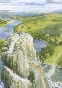
Carrock |
The
Carrock by Alan Lee
|
 Tall
island of rock in the Anduin. The Carrock
was located about 25 miles north of the Old
Forest Road that ran from the
Misty
Mountains through Mirkwood. It was a great
stone peak in the middle of the river. On the western side of the Carrock
there was a high cliff and the river was strong. But on the eastern side,
there was a ford of stepping stones leading from the Carrock to the riverbank.
Tall
island of rock in the Anduin. The Carrock
was located about 25 miles north of the Old
Forest Road that ran from the
Misty
Mountains through Mirkwood. It was a great
stone peak in the middle of the river. On the western side of the Carrock
there was a high cliff and the river was strong. But on the eastern side,
there was a ford of stepping stones leading from the Carrock to the riverbank.
At the base of the Carrock on the eastern side there was a shallow cave with a pebbly floor. A flight of stone steps climbed up the Carrock to the top, where there was a small flat space.
The stairs were made by Beorn, who lived nearby on the eastern side of the Anduin. It was he who named the island the Carrock. Beorn sometimes visited the Carrock at night in the form of a bear.
In 2941 of the Third Age, Bilbo Baggins was brought to the Carrock along with Gandalf and the Dwarves by the Great Eagles. They descended from the peak of the Carrock - where the Eagles had set them - and crossed to the east bank of the Anduin on the way to Beorn's house.
Names &
Etymology:
The word carrock is derived
from the Gaelic for "rock." In Old Welsh the word is carrecc; in
modern Welsh it is careg; in Old Irish it is carric; and
in modern Irish it is carraig. The word carrock can be found
in the British place name Carrock Fell, a rocky summit in the Lake
District.
Sources:
The Hobbit:
"Queer
Lodgings," p. 123-26, 135, 140-41, 144-45, 147
MacBain's
Dictionary: An Etymological Dictionary of the Gaelic Language
Names &
Etymology:
The word elvet is an old
word meaning "swan" from the Old English elfetu or ilfetu.
Sources:
"The Adventures
of Tom Bombadil" in A Tolkien Reader: "Bombadil Goes Boating,"
p. 205, 210
Old English
Names &
Etymology:
Girdley Island was so called
because it was "girdled" by the Brandywine. The element -ey is from
the Old Norse meaning "island."
Source:
The Fellowship
of the Ring: Map of a Part of the Shire
The Lord
of the Rings: A Reader's Companion by Wayne G. Hammond and Christina
Scull: "The Maps of The Lord of the Rings," p. lviii
HimlingIsland in the Sea northwest of Middle-earth. Himling was about 15 miles off the coast of northern Lindon. The larger island of Tol Fuin was located west of Himling. Tol Morwen was southwest of Himling.Himling was once a hill named Himring in Beleriand where Maedhros, son of Feanor, had his fortress. Beleriand sank under the Sea after the War of Wrath at the end of the First Age, and the peak of Himring remained above the waves as the island of Himling. Names &
Etymology:
Sources:
|
Map
of Himling, Tol Fuin, and Tol Morwen
(Location of Tol Morwen is approximate) 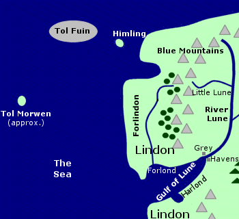 |
Isle of Balar |
Map
of the Isle of Balar
|
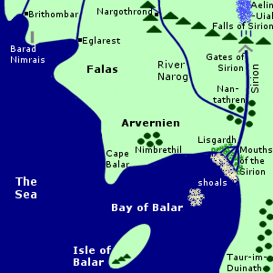 Island
off the coast of Beleriand. The Isle of Balar was located in the Bay of
Balar which opened onto the Sea on the west coast of Middle-earth. The
island was deeply rooted in the shoals near the Mouths of the Sirion which
flowed into the Bay of Balar.
Island
off the coast of Beleriand. The Isle of Balar was located in the Bay of
Balar which opened onto the Sea on the west coast of Middle-earth. The
island was deeply rooted in the shoals near the Mouths of the Sirion which
flowed into the Bay of Balar.
Many pearls including a large, beautiful one called Nimphelos were found in the shallow waters around the Isle of Balar. There were mountains on the southwestern side of the island.
The Isle of Balar was created around 1132 of the Years of the Trees. Ulmo, Lord of the Waters, moved a large island into the Bay of Balar from far out at Sea. He then used the island to transport the Elves from Middle-earth to the Undying Lands. The greater part of island became Tol Eressea off the coast of Aman, but the eastern horn broke off and remained in the Bay of Balar and this became the Isle of Balar.
Osse - one of the Maiar in Ulmo's service - often visited the Isle of Balar. The Sindarin name for Osse was Balar and the island was named for him. The name Beleriand - meaning "the country of Balar" - was given to the coastal lands around the Sirion near the Isle of Balar though the term later encompassed a larger region.
Elves from the realm of Nargothrond considered using the Isle of Balar as a refuge from Morgoth but they never did so. After the Battle of Sudden Flame in 455, Turgon of Gondolin sent some of his people to the Isle of Balar to build ships in an attempt to seek the help of the Valar in the Undying Lands but they were unsuccessful. According to one account (HoME XI, p. 54) Turgon maintained a secret refuge on the Isle of Balar though other accounts seem to contradict this.
In 473 - the year after the Battle of Unnumbered Tears - Morgoth's forces captured the Havens of Brithombar and Eglarest in the coastal region of the Falas. Some of the Elves escaped including Cirdan and Gil-galad. They made a new settlement on the Isle of Balar and others joined them over the years. Cirdan's people also kept ships hidden around the Mouths of the Sirion.
Turgon sent more messengers to the Isle of Balar to build ships with Cirdan's help. None of the ships reached the Undying Lands and none ever returned. But one mariner named Voronwe survived and he led Tuor to Gondolin. Tuor married Turgon's daughter Idril and they had a son Earendil. When Gondolin was destroyed in 510, Tuor and his family and other survivors settled at the Mouths of the Sirion and they were befriended by the Elves on the Isle of Balar.
The Havens of Sirion were attacked by the sons of Feanor in 538 and the survivors fled to the Isle of Balar. One source (HoME XI, p. 345) indicates that soon afterwards, the remaining free Elves and Men of Beleriand were driven out by Morgoth's forces and took refuge on the Isle of Balar.
Earendil succeeded in reaching the Undying Lands around 542 in the ship Vingilot which he had built with Cirdan's help. Earendil made a plea to the Valar on behalf of the peoples of Middle-earth and they defeated Morgoth in the War of Wrath. During the war, most of Beleriand was destroyed and the Isle of Balar was apparently lost as well.
Names &
Etymology:
Balar was the Sindarin name
for Ossë, a Maia in Ulmo's service who visited the island. The word
balar
- or bálâre - derives from the root bal meaning
"power" from which the word Valar also comes. (In older versions
of the story, Ossë was one of the Valar.)
Sources:
The Silmarillion:
"Of Eldamar and the Princes of the Eldalie," p. 57-59; "Of the Sindar,"
p. 92; "Of Beleriand and Its Realms," p. 121; "Of the Ruin of Beleriand,"
p. 159; "Of the Fifth Battle," p. 196; "Of Tuor and the Fall of Gondolin,"
p. 244; "Of the Voyage of Earendil," p. 246-47; Index, entry for Beleriand;
"Appendix - Elements in Quenya and Sindarin Names," entry for val
Unfinished
Tales: "Of Tuor and His Coming to Gondolin," p. 34, 49, 51 note 1,
53 notes 10 and 13, 55 note 28; "The History of Galadriel and Celeborn,"
p. 247
The History
of Middle-earth, vol. V, The Lost Road and Other Writings: "The Etymologies,"
entry for BAL
The History
of Middle-earth, vol. XI, The War of the Jewels: "The Grey Annals,"
p. 5, 7, 11, 54, 104, 107, 125, 136; "The Later Quenta Silmarillion," p.
184 (map); "The Tale of Years," p. 345
Numenor sank beneath the Sea in 3319 of the Second Age, but some believed that the summit of Meneltarma rose out of the water and became an island in the Sea west of Middle-earth. It was hoped that from the Isle of Meneltarma a person might have a vision of things as they had once been and perhaps even see a glimpse of the Undying Lands. Mariners sought the Isle of Meneltarma but no one ever found it.
Names &
Etymology:
The name Meneltarma means
"Pillar of Heaven" in Quenya from menel meaning "heaven" and tarma
meaning "pillar."
Source:
The Silmarillion:
"Akallabeth," p. 281; "Appendix - Elements in Quenya and Sindarin Names,"
entries for menel and tar
Tindrock (Tol Brandir) |
The
Tindrock in the New Line film
|
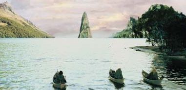 Island
in Nen Hithoel on the Anduin.
The Tindrock was at the southern end of the lake above the Falls
of Rauros. On the western shore just south of the Tindrock stood Amon
Hen, the Hill of Sight, and on the eastern shore was Amon
Lhaw, the Hill of Hearing.
Island
in Nen Hithoel on the Anduin.
The Tindrock was at the southern end of the lake above the Falls
of Rauros. On the western shore just south of the Tindrock stood Amon
Hen, the Hill of Sight, and on the eastern shore was Amon
Lhaw, the Hill of Hearing.
The Tindrock was a tall island with steep sides. Sheer cliffs rising out of the water formed its base. Farther up, the sides of the island sloped somewhat and trees grew there. At the top was a spire of grey stone. Birds circled around the Tindrock, but it was said that no man or beast had ever set foot on the island.
The Fellowship came in sight of the Tindrock on February 25, 3019 of the Third Age. After the breaking of the Fellowship the next day, Frodo Baggins and Sam Gamgee rowed across Nen Hithoel around the southern side of the Tindrock, struggling against the strong current above the falls.
Names &
Etymology:
The name Tindrock means "spiked
rock." The word tind is Old English meaning "tine, spike, prong."
Also called Tindrock Isle.
Called Tol Brandir in Sindarin. The word tol means "island with sheer sides." The word brandir is said to be a corruption of baradnir meaning "tower-steep" or "steep tower." Barad means "tower" and there is also an adjective baradh meaning "steep" but the meaning of nir is unclear.
Sources:
The Fellowship
of the Ring: "Farewell to Lorien," p. 389; "The Great River," p. 396,
405-6, 410; "The Breaking of the Fellowship," 411-13, 417, 423
The Two
Towers: "The Departure of Boromir," p. 19; "The Riders of Rohan," p.
28, 38, 43; "The Passage of the Marshes," p. 237; "The Window on the West,"
p. 275
The Silmarillion:
"Appendix - Elements in Quenya and Sindarin Names," entries for barad
and tol
The History
of Middle-earth, vol. V, The Lost Road and Other Writings: "The Etymologies,"
entry for BARAD
"Nomenclature
of The Lord of the Rings," entry for Tindrock
The Lord
of the Rings: A Reader's Companion by Wayne G. Hammond and Christina
Scull: "Farewell to Lorien," p. 333-34
Tol Eressëa |
Map
of Tol Eressea
|
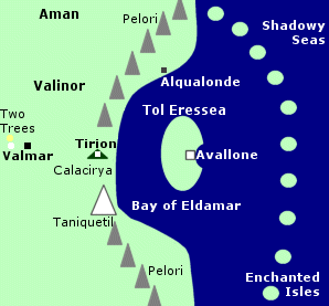 The
Lonely Isle in the Undying Lands. Tol Eressea was inhabited by Elves. First
the Teleri lived there, and then the island became home to the Noldor and
Sindar who left Middle-earth after the end of the First Age. Tol Eressea
was also the place where Frodo Baggins, Bilbo
Baggins, and Sam Gamgee came to dwell when they
were allowed to sail to the Undying Lands.
The
Lonely Isle in the Undying Lands. Tol Eressea was inhabited by Elves. First
the Teleri lived there, and then the island became home to the Noldor and
Sindar who left Middle-earth after the end of the First Age. Tol Eressea
was also the place where Frodo Baggins, Bilbo
Baggins, and Sam Gamgee came to dwell when they
were allowed to sail to the Undying Lands.
Tol Eressea was located in the Bay of Eldamar on the east coast of the main continent of Aman. Valinor - the land of the Valar - was in Aman, and a great mountain range named the Pelori ran along the east coast of the continent. At the Bay of Eldamar, there was a gap in the Pelori called Calacirya, the Pass of Light. The city of Tirion was in the Pass of Light facing Tol Eressea.
The Pass allowed the light of the Two Trees of Valinor to reach the western side of Tol Eressea, which became rich and green. The first flowers to grow east of the Pelori bloomed there. Flowers of Tol Eressea included elanor and lissuin.
Many types of trees grew in Tol Eressea such as oiolaire, lairelosse, nessamelda, vardarianna, taniquelasse, yavannamire, and the mallorn. The white tree Celeborn grew in Tol Eressea from a sapling of Galathilion which had been made by Yavanna in the image of Telperion - one of the Two Trees. From Celeborn later came the White Tree of Gondor.
Avallone was a beautiful white city with a large harbor on the coast of Tol Eressea. The Tower of Avallone was the first thing seen by mariners approaching the Undying Lands. The chief palantir called the Master-stone was kept in the Tower of Avallone.
East of Tol Eressea were the Shadowy Seas and the Enchanted Isles. Outsiders who tried to reach the Undying Lands became bewildered by the treacherous waters and got lost among the chain of islands that stretched from north to south before the Bay of Eldamar. Anyone who landed on one of the Enchanted Isles would be trapped and fall into a deep slumber.
Tol Eressea was originally an island in the middle of the Sea far from the shores of both Aman and Middle-earth. It had been formed during the upheaval caused by the destruction Illuin - one of the Lamps of the Valar that Morgoth attacked in the 3,450th Year of the Valar.
In 1132 of the Years of the Trees, Ulmo, Lord of Waters, uprooted the island and brought it to the Bay of Balar on the west coast of Middle-earth. He used the island to transport the Elves to the Undying Lands. First the Vanyar and the Noldor were taken west across the Sea on the island. When the island left the Bay of Balar, the eastern horn broke off and remained in the bay and became the Isle of Balar.
The Teleri lingered on the shores of Middle-earth and learned sea-lore from Osse, a Maia in Ulmo's service. But in 1149 Ulmo returned to Middle-earth with the island and many of the Teleri decided to follow their kindred. In 1150, the island carried them westward over the Sea. They arrived in the Bay of Eldamar in 1151, but because of their friendship with Osse and their love of the Sea they chose to stay on the island rather than go ashore.
Osse rooted the island in the Bay of Eldamar and it became Tol Eressea, the Lonely Isle. The Teleri lived on Tol Eressea until 1161 of the Years of the Trees (the equivalent of 100 solar years). During that time, their language became distinct from that of the Vanyar and Noldor who lived in Valinor.
The Teleri missed their kindred and they were drawn to the light of the Two Trees, so at last they decided to go ashore. Osse taught them to build ships and they sailed from Tol Eressea to the continent and built the haven of Alqualonde on the north shore of the Bay of Eldamar.
The Two Trees were destroyed by Morgoth around 1495. The Valar created the Enchanted Isles and the Shadowy Seas as a deterrent to Morgoth after he attacked the Moon around 1500. Also around this time, many of the Noldor went to Middle-earth to retrieve the Silmarils that Morgoth had stolen. The Noldor who left were exiled from the Undying Lands by the Valar.
At the end of the First Age, Earendil became the first mariner from Middle-earth to successfully pass through the Shadowy Seas and Enchanted Isles to the Undying Lands. He beseeched the Valar to help the peoples of Middle-earth and they defeated Morgoth in the War of Wrath.
Afterwards, the Valar pardoned the Noldor and many of them returned to the Undying Lands to live on Tol Eressea. Many Sindarin Elves who had never left Middle-earth joined the Noldor on Tol Eressea. Among the Elves who eventually migrated to Tol Eressea was Pengolodh, a loremaster who preserved much of the history of the First Age. The Elves of Tol Eressea spoke Sindarin as they had in Middle-earth.
At the beginning of the Second Age, the Valar created the island of Numenor as a gift for the Men who had helped the Elves in their struggle against Morgoth. Numenor was located in the Sea between Middle-earth and the Undying Lands. It was sometimes possible to see Avallone in Tol Eressea from Numenor.
The Elves of Tol Eressea gave the Men of Numenor different kinds of birds, flowers, and trees including a sapling of the white tree Celeborn named Nimloth. At first there was friendship between the Elves and the Numenoreans, and ships often sailed from Tol Eressea to Numenor. But Men were forbidden to sail west to the Undying Lands because the Valar feared they would begin to desire immortality which they could not attain.
Most Numenoreans did begin to covet immortality and they became estranged from the Elves, but a group who called themselves the Faithful remained friendly with the Elves. The Faithful lived mainly on the west coast of Numenor around the haven of Andunie, and the Elves of Tol Eressea continued to visit them, though by the reign of Ar-Adunakhor (2899-2962) they did so in secret.
During the reign of Ar-Gimilzor (3102-3177), the Elves of Tol Eressea were accused of spying for the Valar and they were forbidden to come to Numenor and anyone who had contact with them was punished. In 3319, Ar-Pharazon - at the urging of Sauron - tried to conquer the Undying Lands in a misguided attempt to attain immortality. His fleet filled the Bay of Eldamar and surrounded Tol Eressea.
The Valar called upon Eru who intervened and caused Ar-Pharazon's fleet and the island of Numenor to sink beneath the Sea. The Faithul led by Elendil escaped and established the Kingdoms of Gondor and Arnor in Middle-earth. They had seven palantiri that had been given to Elendil's father Amandil by the Elves. The one called the Elendil Stone was linked to the Master-stone in the Tower of Avallone in Tol Eressea.
After the destruction of Numenor, Eru changed the shape of the world. The Seas were bent and the earth was made round. Aman and Tol Eressea were removed from the Circles of the World so that the ships of Men could not go there. But the ships of the Elves were able to traverse the Straight Road that passed through the heavens like an invisible bridge until it reached the Undying Lands. During the Third Age, many Elves left Middle-earth, particularly from the Grey Havens.
After the War of the Ring, special permission was granted to Frodo and Bilbo Baggins to sail to the Undying Lands because of the great burden of bearing the One Ring. Galadriel had made a special prayer to the Valar on Frodo's behalf, and Arwen also asked Gandalf, as an emissary of the Valar, to intercede.
Frodo and Bilbo embarked from the Grey Havens on September 29, 3021. They were joined by Sam Gamgee in the year 61 of the Fourth Age. They were mortal and therefore they eventually died, but it is believed that they lived out the remainder of their days in peace on the island of Tol Eressea in sight of Valinor.
Note:
In early stories found in The
Book of Lost Tales, Tol Eressea was an island linked to the
mythic history of England. A mariner named Eriol or Aelfwine comes to Tol
Eressea and visits the Cottage of Lost Play where he hears many tales told
by the Elves. In one version, Tol Eressea is later relocated and becomes
England and the Elves diminish as Men come to live there. In another version,
Tol Eressea is an island to which the Elves fled after Men drove them from
England, and Aelfwine comes from England to seek them out.
Names &
Etymology:
The name Tol Eressëa
means "the Lonely Isle" in Quenya. The word tol means "island" and
eressëa
means "lonely" derived from er meaning "one, alone" and eressë
meaning "solitude." Also called simply Eressëa. Called in the
Common Speech the Lonely Isle and the Lost Isle.
Sources:
The Silmarillion:
"Of the Coming of the Elves," p. 50; "Of Eldamar," p. 57-59; 61; "Of the
Sun and the Moon," p. 102; "Of the Voyage of Earendil," p. 248, 250, 254;
"Akallabeth," p. 260, 262-64, 268, 278-79, 281-82; "Of the Rings of Power
and the Third Age," p. 286-87, 292, 296
The Fellowship
of the Ring: "The Council of Elrond," p. 257
The Return
of the King: "The Field of Cormallen," p. 235
Appendix
A of The Lord of the Rings: "The Numenorean Kings," p. 315; "The North-kingdom
and the Dunedain," p. 322 note 2
Appendix
B of The Lord of the Rings: "The Tale of Years," p. 363
Unfinished
Tales: "A Description of the Island of Numenor," p. 167, 170; "Aldarion
and Erendis," p. 183-84, 189, 215 note 17, 216 note 19; "The Line of Elros,"
p. 222-23; "The History of Galadriel and Celeborn," p. 229, 242, 250, 266;
"The Palantiri," p. 414 note 16
The History
of Middle-earth, vol. I, The Book of Lost Tales Part One: "The Cottage
of Lost Play," passim
The History
of Middle-earth, vol. II, The Book of Lost Tales Part Two: "The History
of Eriol or Aelfwine," passim
The History
of Middle-earth, vol. IV, The Shaping of Middle-earth: "The Ambarkanta,"
p. 249 (map)
The History
of Middle-earth, vol. V, The Lost Road and Other Writings: "The Etymologies,"
entry for ERE
The History
of Middle-earth, vol. X, Morgoth's Ring: "The Annals of Aman," p. 53,
84-87, 91, 100, 133-34; "The Later Quenta Silmarillion," p. 178, 183; "Athrabeth
Finrod Ah Andreth," p. 341, 365-66
The History
of Middle-earth, vol. XI, The War of the Jewels: "The Grey Annals,"
p. 7-8, 21-23; "Quendi and Eldar," p. 396-97
The Letters
of J.R.R. Tolkien: Letter #131, #154, #246, #297 (footnote), #325
Names &
Etymology:
Also written as Tol Falas.
The name means "coastal island" from tol meaning "island with sheer
sides" and falas meaning "shore, coast."
Sources:
Map of Middle-earth
by Christopher Tolkien
The History
of Middle-earth, vol. V, The Lost Road and Other Writings: "The Etymologies,"
entries for PHAL, PHALAS and TOL
Tol FuinIsland off the coast of northwestern Middle-earth. Tol Fuin was located just west of the smaller island of Himling. Tol Morwen was southwest of Tol Fuin. The islands were in the Sea west of the northernmost part of Lindon.Tol Fuin was formed at the end of the First Age when Beleriand was ruined in the War of Wrath and much of the land sank beneath the Sea. The island of Tol Fuin was all that remained of the forested highlands of Taur-nu-Fuin, a place of fear and dread where Sauron once dwelled. Note:
Names &
Etymology:
Sources:
|
Map
of Himling, Tol Fuin, and Tol Morwen
(Location of Tol Morwen is approximate)  |
Tol Morwen |
Map
of Himling, Tol Fuin, and Tol Morwen
(Location of Tol Morwen is approximate) |
 Island
formed from the gravestone of Turin, Nienor,
and Morwen after the destruction of Beleriand.
Tol Morwen was located in the Sea off the coast of Lindon.
It was to the southwest of the islands of Tol Fuin
and
Himling. Tol Morwen does not appear on any maps
and its exact location is uncertain.
Island
formed from the gravestone of Turin, Nienor,
and Morwen after the destruction of Beleriand.
Tol Morwen was located in the Sea off the coast of Lindon.
It was to the southwest of the islands of Tol Fuin
and
Himling. Tol Morwen does not appear on any maps
and its exact location is uncertain.
In 499 of the First Age, Turin slew Glaurung at the Ravines of Teiglin at the edge of the Forest of Brethil in Beleriand. Turin then learned that he had unwittingly married his sister Nienor, who killed herself by jumping from a gorge of the Teiglin called the Deer's Leap when she found out.
Turin also committed suicide. He was buried in a high mound where he fell, near the place where the Dragon's corpse had been burned and Nienor had leapt to her death.
A great grey stone was placed over Turin's grave. The stone was carved with runes that read Túrin Turambar Dagnir Glaurunga meaning "Turin, Master of Doom, Glaurung's Bane." Beneath this the name Nienor Níniel was carved though her body was never recovered from the river.
The gravestone was called the Stone of the Hapless. The people of the Forest of Brethil also called it the Talbor or the Standing Stone.
Around 501, Morwen, the mother of Turin and Nienor, found the stone and realized her children were dead. She waited there until the arrival of her husband Hurin and then she died. She was buried on the west side of the gravestone and another inscription was carved reading Here lies also Morwen Eledhwen.
A seer and harpist of Brethil named Glirhuin wrote a song foretelling that the Stone of the Hapless would not be defiled by Morgoth and would remain standing even if the Sea covered the land. Most of Beleriand sank beneath the Sea during the War of Wrath at the end of the First Age, but the Stone of the Hapless remained above water as an island called Tol Morwen.
Names &
Etymology:
Tol Morwen was named after
Morwen, mother of Turin and Nienor, all of whom were memorialized on the
Stone of the Hapless. The word tol means "island (rising with sheer
sides from the Sea or a river)."
Sources:
The Silmarillion:
"Of Turin Turambar," p. 225-26; "Of the Ruin of Doriath," p. 229-30; "Appendix
- Elements in Quenya and Sindarin Names," entry for tol
The History
of Middle-earth, vol. XI, The War of the Jewels: "The Grey Annals,"
p. 102-3; "The Wanderings of Hurin," p. 251-52, 258-59, 295-96
The Children
of Hurin: "The Death of Turin," p. 257-59
Aldarion built the light-tower Calmindon on Tol Uinen. Off the coast of Tol Uinen, Aldarion anchored his ship Eambar which he used as a home and as the guildhouse for the Guild of Venturers.
Tol Uinen was presumably destroyed along with Numenor in 3319 of the Second Age.
Names &
Etymology:
The word tol means "island."
Uinenmay
contain the Quenya words uile meaning "long trailing plant, especially
seaweed" and nen meaning "water," although in one source
(HoME
XI, p. 404) Tolkien states that
Uinen is not Elvish but
instead may come from the language of the Valar.
Sources:
Unfinished
Tales: "Aldarion and Erendis," p. 176, 182
The Silmarillion:
"Appendix - Elements in Quenya and Sindarin Names," entries for nen
and tol
The History
of Middle-earth, vol. V, The Lost Road and Other Writings: "The Etymologies,"
entry for UY
The History
of Middle-earth, vol. XI, The War of the Jewels: "Quendi and Eldar,"
p. 404
The
Quenya Corpus Wordlist
All entries are Copyright © by the Thain from former tuckborough.net. Please contact me if you are Thain or know anything about how to contact the original author.
2003-2011, The Thain's Book - thainsbook.minastirith.cz
- e-mail: thain at tuckborough.net