
An encyclopedia of Middle-earth and Numenor
|
|
|
|
|
|
|
|
|
|
|
|
|
|
| |
|
|
An encyclopedia of Middle-earth and Numenor |
|

Ard-galen / Anfauglith |
Map
of Anfauglith
|
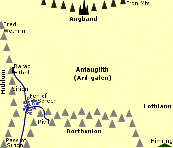 Plain
south of Angband that became a desert in the
Battle
of Sudden Flame. Ard-galen was a wide grassy plain between the highlands
of Dorthonion in the south and the Iron Mountains in the north. The Ered
Wethrin were on its western border, and the Sirion skirted the southwestern
corner. The plain of Lothlann and the Blue
Mountains lay to the east.
Plain
south of Angband that became a desert in the
Battle
of Sudden Flame. Ard-galen was a wide grassy plain between the highlands
of Dorthonion in the south and the Iron Mountains in the north. The Ered
Wethrin were on its western border, and the Sirion skirted the southwestern
corner. The plain of Lothlann and the Blue
Mountains lay to the east.
Morgoth returned to Middle-earth around 1495 of the Years of the Trees and rebuilt Angband. He sent Orcs to invade Hithlum in 1497 but the Elves defeated them in the Battle-under-Stars and drove them over the Ered Wethrin into Ard-galen. Celegorm then forced the Orcs into the Fen of Serech and most of them perished.
Desolation had spread southward for miles across Ard-galen from Angband after Morgoth's arrival. But when the Sun first rose at the beginning of the First Age, green grass grew on the plain.
In the year 60 of the First Age, an army of Orcs attacked Dorthonion but they were defeated by the Elves in the Glorious Battle. Fingolfin and Maedhros drove the Orcs back across Ard-galen to Angband and killed all of them before they reached the gates.
The Elves then implemented the Siege of Angband to prevent Morgoth from launching another invasion. Cavalry from Hithlum patrolled the plain of Ard-galen and the horses thrived on the green grass. The Elves of Hithlum watched over Ard-galen from Barad Eithel. Angrod and Aegnor also kept watch on Ard-galen from the highlands of Dorthonion.
In 260, Glaurung emerged from Angband and defiled the grassy fields of Ard-galen. Many of the Elves keeping watch fled from the Dragon, but Fingon led a company of archers to drive Glaurung back to Angband. The Siege of Angband continued after this breach.
Morgoth broke the Siege of Angband with the Battle of Sudden Flame in 455. Rivers of fire poured down from Angband and ruined Ard-galen. The grass was scorched and the plain became a barren desert which was renamed Anfauglith, the Gasping Dust. Many Elves died in the fire and their bones remained in the desert. After the battle, Fingolfin rode across Anfauglith on his horse Rochallor to Angband where he challenged Morgoth to single combat and was slain.
Morgoth attacked Hithlum in 462, but Hurin pursued the attackers back across Anfauglith. In 469, the Union of Maedhros drove Morgoth's Orcs from Beleriand, and Anfauglith became a no man's land which neither side controlled. That same year Morgoth sent a pestilent wind called the Evil Breath to the lands bordering Anfauglith and many people died.
In 472, Maedhros attempted to draw Morgoth's forces out onto Anfauglith and trap them between two armies attacking from the east and west. But the plans went awry and Morgoth was victorious. Many Elves and Men were killed in the Battle of Unnumbered Tears and they were buried under a mound in the middle of Anfauglith. The burial mound was named Haudh-en-Ndengin - the Hill of the Slain - or Haudh-en-Nirnaeth - the Hill of Tears. The hill was the only place in Anfauglith where grass grew, and Morgoth's servants avoided it.
During the War of Wrath at the end of the First Age, Morgoth's forces were so great that they filled Anfauglith and the fighting extended throughout the North. But Morgoth was defeated by the Host of the Valar and most of the land west of the Blue Mountains was destroyed including Anfauglith.
Names &
Etymology:
The name Ard-galen means
"Green Region" in Sindarin from ardh meaning "region" and galen
meaning "green." After it became a desert it was called Anfauglith
meaning "Gasping Dust" from an meaning "long," faug meaning
"thirsty," and lith meaning "ash" or "sand." Also called Dor-nu-Fauglith
meaning "Land under Choking Ash" from dor meaning "land" and nu
meaning "under."
Sources:
The Silmarillion:
"Of the Return of the Noldor," p 106-7, 115-16; "Of Beleriand and Its Realms,"
p. 118-20, 123; "Of the Ruin of Beleriand," p. 150-51, 160; "Of Beren and
Luthien," p. 178; "Of the Fifth Battle," p. 190-95, 197; "Of Turin Turambar,"
p. 207-8, 212; "Of the Ruin of Doriath," p. 227; "Of the Voyage of Earendil,"
p. 251; "Appendix - Elements in Quenya and Sindarin Names," entries for
an(d),
calen, dor, faug, lith
Unfinished
Tales: "Of Tuor and His Coming to Gondolin," p. 17; "Narn I Hin Hurin,"
p. 58
The History
of Middle-earth, vol. V, The Lost Road and Other Writings: "The Etymologies,"
entries for 3AR, LIT, NU, PHAU
The History
of Middle-earth, vol. XI, The War of the Jewels: "The Grey Annals,"
p. 17, 36, 38, 46, 52, 55, 60, 63, 68, 70-73, 79, 85, 111, 113-14, 167-68;
"The Later Quenta Silmarillion," p. 183 (map); "The Wanderings of Hurin,"
p. 252
The Bonfire Glade was a wide, circular clearing. The trees formed a thick wall around the edges. No trees grew in the Bonfire Glade but the ground was covered with grass and tall plants.
The Bonfire Glade was created by the Hobbits of the Shire after the trees of the Old Forest attacked the High Hay. The Hobbits cut down hundreds of trees and built a great bonfire. The trees ceased their attack but remained hostile to Hobbits who entered the forest.
On September 26, 3018 of the Third Age, Merry Brandybuck led Frodo Baggins, Sam Gamgee, and Pippin Took to the Bonfire Glade as they began their journey through the Old Forest.
Names &
Etymology:
A glade is a small open space
in a forest.
Sources:
The Fellowship
of the Ring: "The Old Forest," p. 121-23
Sources:
The Fellowship
of the Ring: Map of "A Part of the Shire"; "A Conspiracy Unmasked,"
p. 118
But at the end of the Second Age, Sauron scorched the earth to prevent the Men and Elves of the Last Alliance from making use of the Entwives' crops. The Entwives disappeared and the Brown Lands stood empty throughout the Third Age.
Names &
Etymology:
The Brown Lands were so called
because they were barren earth with no vegetation. The Sindarin name was
Berennyn
from baran meaning "brown."
Sources:
The Fellowship
of the Ring: "The Great River," p. 396-97
The Two
Towers: "The Uruk-hai," p. 62; "Treebeard," p. 79
The Letters
of J.R.R. Tolkien: Letter #144
The Lord
of the Rings: A Reader's Companion by Wayne G. Hammond and Christina
Scull: "The Great River," p. 343
Dagorlad |
Map
of Dagorlad
|
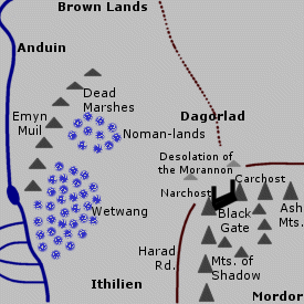 Battle
Plain outside Mordor. Dagorlad was a vast, barren
expanse of stony terrain in the desolate Noman-lands
north of the Black Gate. A
strip of wasteland called the Desolation of the Morannon stretched between
Dagorlad and the Black Gate.
Battle
Plain outside Mordor. Dagorlad was a vast, barren
expanse of stony terrain in the desolate Noman-lands
north of the Black Gate. A
strip of wasteland called the Desolation of the Morannon stretched between
Dagorlad and the Black Gate.
The Dead Marshes and the sheer cliffs of the Emyn Muil were west of Dagorlad. The Brown Lands were to the north. To the northeast were the open plains of Wilderland that bordered on Rhun.
A road ran northward from the Black Gate across Dagorlad, possibly to Dol Guldur in Mirkwood. Other highways also crossed the plain, used by Orcs and Men in the service of Sauron.
At the start of the War of the Last Alliance in 3434 of the Second Age, a great battle was fought on the plain between Sauron's forces and the Elves and Men of the Last Alliance. The plain was afterwards called Dagorlad, the Battle Plain. Sauron's forces were defeated in the Battle of Dagorlad, but the war continued for seven more years with the Siege of Barad-dur until Sauron was vanquished by Gil-galad and Elendil and the One Ring was taken from him by Isildur.
Many Elves, Men and Orcs died during the Battle of Dagorlad and their bodies were buried on the plain. Over time, the marshes west of Dagorlad encroached on the plain and covered some of the graves. It was said that the bodies could still be seen centuries later in the waters of the marshes, which became known as the Dead Marshes.
In the Third Age, the Wainriders from Rhun launched a series of attacks on Gondor. In 1856, the Battle of the Plains was fought on the open lands northeast of Dagorlad. Gondor's army was defeated and they retreated across Dagorlad to Ithilien. In 1899, King Calimehtar of Gondor defeated the Wainriders in a battle fought on Dagorlad.
When the Wainriders attacked again in 1944, King Ondoher intended to meet them on Dagorlad but instead his army was surprised by the enemy as they approached the Black Gate from Ithilien. Ondoher and the Northern Army of Gondor were defeated, but Earnil and the Southern Army later routed the Wainriders in the Battle of the Camp in Ithilien.
During the War of the Ring in 3019, the Battle of the Morannon was fought on the Desolation of the Morannon between Dagorlad and the Black Gate.
Names &
Etymology:
The name Dagorlad means "Battle
Plain" in Sindarin from
dagor meaning "battle" and lad meaning
"plain."
Sources:
The Fellowship
of the Ring: "The Council of Elrond," p. 256
The Two
Towers: "The Taming of Smeagol," p. 209-10; "The Passage of the Marshes,"
p. 232, 235; "The Window on the West," p. 279
The Return
of the King: "The Muster of Rohan," p. 72
Appendix
A of The Lord of the Rings: "Gondor and the Heirs of Anarion," p. 329
Unfinished
Tales: "The History of Galadriel and Celeborn," p. 239-40, 243-44,
258; "The Disaster of the Gladden Fields," p. 271; "Cirion and Eorl," p.
289-90, 292, 296, 312 note 15, 319 note 51
The Silmarillion:
"Of the Rings of Power and the Third Age," p. 293, 296; Appendix - Elements
in Quenya and Sindarin Names," entries for dagor and lad
Smaug was slain by Bard the Bowman in 2941. Bard reestablished the town of Dale, and the land around the Lonely Mountain became lush and fertile once more.
Names &
Etymology:
Also called the Desolation of
the Dragon.
Sources:
The Hobbit:
Map of Wilderland; "An Unexpected Party," p. 32-33; "On the Doorstep,"
p. 216-17; "Fire and Water," p. 266; "The Last Stage," p. 316-17
The Fellowship
of the Ring: "Many Meetings," p. 242
The Lord
of the Rings: A Reader's Companion by Wayne G. Hammond and Christina
Scull: "Many Meetings," p. 208
The East Bight was created by the Northmen who inhabited the plains east of Mirkwood. They cut down many trees and built homes and stables for their horses in the clearing.
In 1851 of the Third Age, the Northmen were attacked by the Wainriders from Rhun. After the Battle of the Plains in 1856, the Northmen were enslaved by the Wainriders. In 1899, the Northmen staged a rebellion coordinated with an attack on the Wainriders by King Calimehtar of Gondor. But although Gondor's army defeated the Wainriders, the revolt of the Northmen was unsuccessful and most were killed.
Some Northmen led by Marhwini had escaped after the Battle of the Plains and settled in the Vales of the Anduin west of Mirkwood. They were known as the Eotheod and later became the Rohirrim.
Names &
Etymology:
The word bight means a curve
or bay in a coastline but here refers to an indentation in the edge of
a forest.
Sources:
Unfinished
Tales: "Cirion and Eorl," p. 288-91, 298, 310 note 3, 312 note 13
Many shepherds lived in white houses in Emerie and flocks of sheep grazed on the downs. Hyarastorni was a large sheep farm in Emerie belonging to Hallatan who was known as the Sheep-lord.
Tar-Meneldur gave a white house and lands in Emerie to Erendis after she became betrothed to his son Aldarion in 858 of the Second Age. The house was situated on a westward slope of the downs and it was surrounded by lawns and pastures with no fences.
Erendis moved to her house in Emerie when her husband Aldarion left on a sea voyage against her wishes in 877. She took their daughter Ancalime with her and kept her isolated from others, especially from men. Erendis continued to live in Emerie after her marriage to Aldarion ended in 882. She left Emerie in 985 in search of her husband and died in the waters of the Bay of Romenna.
Ancalime split her time between the royal court in Armenelos and her mother's house in Emerie. When she was grown, suitors came to Emerie hoping to marry the King's heir. Ancalime went into hiding disguised as a shepherdess on a farm bordering Hyarastorni. There she met Hallatan's son Hallacar who was also disguised as a shepherd. Ancalime eventually married Hallacar but they were unhappy. She claimed ownership of his lands in Emerie and forbade him to live there, and after Hallacar humiliated her at a wedding in revenge Ancalime left Emerie herself and never returned.
Names &
Etymology:
The name Emerië contains
the word emer which apparently means "sheep" or "shepherd" in Quenya.
It is related to the word emerwen meaning "shepherdess."
Sources:
Unfinished
Tales: "A Description of the Island of Numenor," p. 166-67; "Aldarion
and Erendis," p. 182, 184, 192-99, 201-2, 204, 206-9, 211-12
Field of Celebrant |
Map
of the Field of Celebrant
|
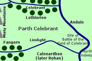 Field
where the ancestors of the Rohirrim first came to the aid of Gondor
against
Sauron's forces. The Field of Celebrant
was located on the western side of the Anduin,
north of the River Limlight. It was
called Parth Celebrant in Sindarin.
Field
where the ancestors of the Rohirrim first came to the aid of Gondor
against
Sauron's forces. The Field of Celebrant
was located on the western side of the Anduin,
north of the River Limlight. It was
called Parth Celebrant in Sindarin.
The name Parth Celebrant referred to the entire open field between the southern border of Lothlorien and the Limlight, bounded on the west by the Misty Mountains and on the east by the Anduin. This area was considered a part of Lothlorien, though no Elves lived there. The woods of Lothlorien had originally extended further south, but they receded over time.
In Gondor the name Parth Celebrant - or Field of Celebrant - was used to refer only to the southeastern corner of the field between the lower Limlight and the Anduin. This area formed part of Gondor's northern border at the height of the realm during the reign of King Hyarmendacil I from 1015 to 1149 of the Third Age. South of the Limlight was the region of Gondor called Calenardhon.
The Field of Celebrant was of strategic importance because the Anduin at this point - in the great bends called the Undeeps - was relatively shallow and easy to cross. A bridge was built over the Limlight and defenses were periodically maintained by Gondor in the Field of Celebrant. Over time, however, the northern defenses diminished and Gondor's attention was diverted elsewhere.
In 2510, it became apparent to Cirion, the Steward of Gondor, that an invasion was imminent over the vulnerable Undeeps by Men from Rhun called the Balchoth, who were under the power of Sauron. Cirion sent messengers to request help from the Eotheod, who lived in the far north near the source of the Anduin. Cirion himself led an army to defend the Undeeps.
The Balchoth crossed the Undeeps on rafts south of the Limlight into Calenardhon and forced Cirion and the Northern Army to retreat northward across the Limlight into the Field of Celebrant. Then a host of Orcs came down from the Misty Mountains and drove the Men of Gondor toward the Anduin. Defeat seemed certain, but then, on the morning of April 15, the Eotheod led by Eorl the Young arrived. The Balchoth and the Orcs were defeated in the Battle of the Field of Celebrant.
In gratitude, Cirion gave the Eotheod the land of Calenardhon south of the Limlight, and it became known as Rohan. With this strong ally on its northern border, Gondor no longer maintained defenses in the Field of Celebrant.
Note:
In Appendix
A of The Lord of the Rings,
it says "The realm [of Gondor] then extended north to Celebrant ..." (p.
325). Tolkien later wrote that this was a typographical error and
that it should read, "The realm [of Gondor] then extended north to the
Field
of Celebrant ..."
Names &
Etymology:
The Field of Celebrant was
called Parth Celebrant in Sindarin. Parth means "field, enclosed
grassland." Celebrant was the name of the river north of the field;
the Common Speech name of this river was the Silverlode.
Sources:
The Two
Towers: "The King of the Golden Hall," p. 116; "The Window on the West,"
p. 327
The Return
of the King: "Many Partings," p. 254
Appendix
A of The Lord of the Rings: "Gondor and the Heirs of Anarion," p. 325;
"The Stewards," p. 333-34; "The House of Eorl," p. 345
Unfinished
Tales: "The History of Galadriel and Celeborn - Appendix C: The Boundaries
of Lorien," p. 260; "Cirion and Eorl," p. 288, 290, 296-300
Frodo Baggins and Sam Gamgee awoke in the beech grove on April 8, 3019 of the Third Age, two weeks after the destruction of the Ring. Gandalf was at their bedside, and the Hobbits were brought out onto the Field of Cormallen where the Host of the West awaited them. Trumpets sounded and the men raised their swords and spears and cried, "Long live the Halflings! Praise them with great praise!" (RotK, p. 231) In the field were three thrones of green turf with the banners of Rohan, Dol Amroth, and Gondor. On the center throne sat their old friend Aragorn, who knelt before Frodo and Sam and sat them on his throne while a minstrel sang of Frodo of the Nine Fingers and the Ring of Doom.
The celebrations at the Field of Cormallen continued and Frodo and Sam were reunited with the rest of the Fellowship. They remained at the camp near the Field of Cormallen until the end of April, when they went to Minas Tirith for Aragorn's coronation on May 1.
Names &
Etymology:
Cormallen means "golden circle"
from cor meaning "round, circular enclosure" and
mallen meaning
"of gold." The name Cormallen is also said to be derived from the
culumalda
trees that grew there; the element cul means "golden-red."
Sources:
The Return
of the King: "The Field of Cormallen," p. 229-235
The Silmarillion:
"Appendix:
Elements in Quenya and Sindarin Names," entries for CUL and MAL
The History
of Middle-earth, vol. V, The Lost Road and Other Writings: "The Etymologies,"
entries for KOR, KUL, and SMAL
Firienfeld |
Early
sketch of the Firienfeld of Dunharrow by J.R.R. Tolkien
|
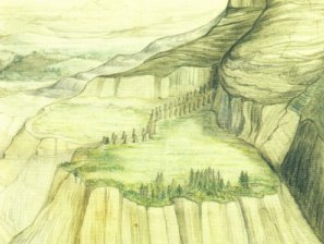 Mountain
field of Dunharrow. The Firienfeld
was located in the valley of Harrowdale
in Rohan. It was a flat, grassy plateau on the
mountainside hundreds of feet above the valley floor. Irensaga
was on the north side of the Firienfeld, the Starkhorn
was to the south, and Dwimorberg,
the Haunted Mountain, was in the center.
Mountain
field of Dunharrow. The Firienfeld
was located in the valley of Harrowdale
in Rohan. It was a flat, grassy plateau on the
mountainside hundreds of feet above the valley floor. Irensaga
was on the north side of the Firienfeld, the Starkhorn
was to the south, and Dwimorberg,
the Haunted Mountain, was in the center.
A zigzag path called the Stair of the Hold led up to the plateau. The Stair was lined with carved figures called Pukel-men. At the top of the Stair, a path continued eastward across the Firienfeld. This path was bordered on either side by uncarved standing stones. The Firienfeld was wider on the south side of the path.
The path led to the dark wood called the Dimholt at the foot of the Dwimorberg. In the mountainside was the Dark Door to the Paths of the Dead.
The plateau of the Firienfeld was used as a mountain refuge called Dunharrow. Dunharrow was probably first used by the Druedain who inhabited the White Mountains in the First Age until they were driven out by the evil Men of the Mountains.
Dunharrow became a sacred place for the Men of the Mountains. At the end of the Second Age, the Men of the Mountains were cursed by Isildur for breaking their oath to fight Sauron and they haunted the Paths of the Dead. They were called the Dead Men of Dunharrow.
After Rohan was founded in 2510 of the Third Age, Dunharrow was used as a refuge by the Rohirrim. When Rohan was occupied by Dunlendings during the Long Winter of 2758-59, a number of Rohirrim held out in Dunharrow until Frealaf led them to oust the invaders. The Rohirrim also took refuge in Dunharrow during the War of the Ring and King Theoden came there on March 9-10, 3019, to oversee the muster of his army.
Names &
Etymology:
The name Firienfeld means
"mountain field" from the Old English firgen meaning "mountain"
and feld meaning "field."
Sources:
The Return
of the King: "The Muster of Rohan," p. 67-71
Appendix
A of The Lord of the Rings: "The House of Eorl," p. 348
Unfinished
Tales: "The Druadan," p. 383-84
Gorgoroth |
Map
of Gorgoroth
|
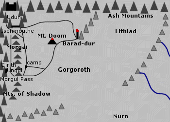 Great
desert plateau in Mordor. Gorgoroth was the northwestern
region of Mordor. It was bordered on the north by the Ash
Mountains and on the west by the Morgai, which was an inner ridge of
the Mountains of Shadow. Two spurs
from the Ash Mountains and the Mountains of Shadow enclosed the southeastern
side of Gorgoroth. A gap between the two spurs opened onto the region of
Nurn
in southern Mordor.
Great
desert plateau in Mordor. Gorgoroth was the northwestern
region of Mordor. It was bordered on the north by the Ash
Mountains and on the west by the Morgai, which was an inner ridge of
the Mountains of Shadow. Two spurs
from the Ash Mountains and the Mountains of Shadow enclosed the southeastern
side of Gorgoroth. A gap between the two spurs opened onto the region of
Nurn
in southern Mordor.
In the northwestern corner of Gorgoroth was the barred pass of Isenmouthe which led into the valley of Udun where the Black Gate stood. On the western side of Gorgoroth, the Morgul Pass spanned the Mountains of Shadow and the Morgai. The Tower of Cirith Ungol overlooked Gorgoroth from above the Morgul Pass.
On the northern side of Gorgoroth, the Dark Tower of Barad-dur stood on a spur of the Ash Mountains. To the east was the ashy plain of Lithlad. Mount Doom rose in the midst of Gorgoroth.
Volcanic eruptions had marked the plain with craters, steaming fissures, and twisted rivers of hardened lava. Gorgoroth was a barren wasteland without water or vegetation. The region of Gorgoroth was used mainly for mining and industry while the southern lands of Nurn were used to grow crops.
A road from the Isenmouthe to Barad-dur ran along the northern edge of Gorgoroth, while another road skirted the Morgai to the Morgul Pass. There were water cisterns at intervals along the roads for troops crossing the desert. A third road crossed Gorgoroth from Barad-dur to Mount Doom and on to the Morgul Pass, with a branch leading off to a large camp on the plain. There were several such camps on Gorgoroth - some even the size of small towns with buildings and streets.
During the War of the Last Alliance, the armies of Elves and Men took Gorgoroth and besieged Barad-dur. The Siege of Barad-dur lasted seven years from 3434 to 3441 of the Second Age. Sauron sent out sorties and attacked the siege army from above with fire and projectiles. Many Elves and Men were killed including Elendil's son Anarion who died in 3440. Sauron came down from Barad-dur in 3441 and fought Elendil and Gil-galad on Mount Doom. All three fell in the struggle and Isildur took the One Ring from Sauron, whose spirit fled into the East.
During the War of the Ring, Sauron's forces gathered on Gorgoroth. Frodo and Sam saw their camps as they looked across Gorgoroth from the Morgai on March 16, 3019 of the Third Age. On March 19, Frodo and Sam began their trek across Gorgoroth. By this time, most of Sauron's troops had moved into Udun, so the Hobbits were able to use the eastward road along the Ash Mountains for a while before turning south toward Mount Doom. Sam cast their gear including his pots and pans into one of the fissures on the plain.
When the Ring was destroyed on March 25, Mount Doom erupted and Gorgoroth was covered with ash and molten lava. Great cracks and pits opened up in the ground and the land was ruined.
Names &
Etymology:
The name Gorgoroth is composed
of
gor and goroth, both meaning "horror" while the doubled
element gorgor means "extreme horror, haunting fear."
Sources:
The Fellowship
of the Ring: "The Council of Elrond," p. 258; "The Breaking of the
Fellowship," p. 417
The Two
Towers: "The Black Gate Is Closed," p. 244, 250; "The Window on the
West," p. 290; "The Stairs of Cirith Ungol," p. 315, 319
The Return
of the King: "The Black Gate Opens," p. 168; 175-77; "The Land of Shadow,"
p. 199-201, 205; "Mount Doom," passim; "The Field of Cormallen," p. 228-29
The Silmarillion:
"Appendix - Elements in Quenya and Sindarin Names," entry for gor
The History
of Middle-earth, vol. VII, The Treason of Isengard: "The Story Foreseen
from Moria," p. 213; "The First Map," p. 309 map III, 313
The History
of Middle-earth, vol. XI, The War of the Jewels: "Quendi and Eldar,"
p. 415
The Lord
of the Rings: A Reader's Companion by Wayne G. Hammond and Christina
Scull: "Farewell to Lorien," p. 334-35
In 2747 of the Third Age, Orcs from the Misty Mountains led by Golfimbul invaded Greenfields. They were defeated by the Hobbits led by Bandobras Took in the Battle of Greenfields.
Names &
Etymology:
Also written as Green Fields.
Sources:
The Hobbit:
"An Unexpected Party," p. 26
The Fellowship
of the Ring: "Prologue: Concerning Hobbits," p. 14
Appendix
B of The Lord of the Rings: "The Tale of Years," p. 369
The Lord
of the Rings: A Reader's Companion by Wayne G. Hammond and Christina Scull:
"Prologue," p. 24
Himlad |
Map
of Himlad
|
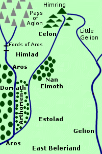 Cool
plain in East Beleriand. Himlad was located between the River Aros and
the River Celon. The East Road came to
Himlad from the west over the Fords of Aros. The forest of Nan
Elmoth was east of Himlad across the Celon.
Cool
plain in East Beleriand. Himlad was located between the River Aros and
the River Celon. The East Road came to
Himlad from the west over the Fords of Aros. The forest of Nan
Elmoth was east of Himlad across the Celon.
South of Himlad, in the angle of land between the Aros and Celon, was a part of Doriath called Arthorien. The greater part of the realm of Doriath lay west of the Aros. Himlad itself was an open land with no trees and a central plateau that was 300 feet high.
Himlad was bordered on the north by Himring and its foothills. The Pass of Aglon separated Himring from the mountains of Dorthonion to the west. A bitterly cold wind blew through the pass from the north and cooled the plain of Himlad. The pass also made Himlad vulnerable to attack from Morgoth's lands in the north.
In the year 7 of the First Age, Himlad was settled by Celegorm and Curufin, two of the sons of Feanor. They fortified and defended the Pass of Aglon. Their eldest brother Maedhros established a stronghold on Himring.
In 316, Aredhel of Gondolin came to Himlad to visit Celegorm and Curufin but they were away in Thargelion. Aredhel strayed across the Celon into Nan Elmoth where Eol the Dark Elf lived, and he made her his wife.
Aredhel and her son Maeglin fled Nan Elmoth in 400, but Eol followed them. In Himlad, Eol was waylaid by Curufin who told him that his wife and son had gone westward. Although Curufin hated Eol, he was obliged to let him go unharmed. Eol continued on to Gondolin where he caused the death of Aredhel and was executed.
During the Battle of Sudden Flame in 455, Morgoth's forces came through the Pass of Aglon and Celegorm and Curufin had to abandon Himlad. Maedhros remained on Himring and he was able to prevent more enemy forces from coming through the Pass for a time, but he too abandoned his stronghold after the Battle of Unnumbered Tears in 472.
Himlad was destroyed along with most of the rest of Beleriand in the War of Wrath at the end of the First Age.
Names &
Etymology:
The name Himlad means "cool
plain" in Sindarin from him meaning "cool" and lad meaning
"plain."
Sources:
The Silmarillion:
"Of Beleriand and Its Realms," p. 123-24; "Of Maeglin," p. 132, 135-36;
"Of the Ruin of Beleriand," p. 152-53; "Appendix - Elements in Quenya and
Sindarin Names," entries for him and lad
The History
of Middle-earth, vol. XI, The War of the Jewels: "Maeglin," p. 332-33,
338 note 4
Source:
The Hobbit:
"An Unexpected Party," p. 27
Names &
Etymology:
Lithlad means "plain of ash"
from lith meaning "ash" and lad meaning "plain."
Sources:
The Two
Towers: "The Black Gate Is Closed," p. 244
The Silmarillion:
"Appendix:
Elements in Quenya and Sindarin Names," entries for lad and lith
The History
of Middle-earth, vol. VII, The Treason of Isengard: "The Story Foreseen
from Moria," p. 213; "The First Map," p. 309 map III, 313
On February 25, 3019 of the Third Age, the Fellowship camped at Parth Galen. The next day, the Fellowship was broken. Merry and Pippin were captured by Uruk-hai and Boromir was slain defending them. Aragorn, Legolas and Gimli brought Boromir's body to Parth Galen and set it in a boat which they sent over the Falls of Rauros; they then left Parth Galen in pursuit of Merry and Pippin. Sam caught up to Frodo at Parth Galen and they set out together across Nen Hithoel to begin their journey to Mordor.
Names &
Etymology:
Parth Galen means "Green
Sward" in Sindarin. (A sward is a grassy surface or turf.) Parth
means "field, enclosed grassland" related to pathw meaning "level
space, sward." Galen (or calen) means "green."
Sources:
The Fellowship
of the Ring: "The Breaking of the Fellowship," 411, 422 and passim
The Two
Towers: "The Departure of Boromir," p. 15, 18-21; "Of Herbs and Stewed
Rabbit," p. 266
Unfinished
Tales: Index entry for "Parth Galen" (definition of Parth Galen);
"The History of Galadriel and Celeborn - Appendix C," p. 260 (definition
of parth)
The Silmarillion:
"Appendix - Elements in Quenya and Sindarin Names" entry for KAL-
(GAL-)
The History
of Middle-earth, vol. 5, The Lost Road and Other Writings: "The Etymologies,"
entry for PATH
The Journeys
of Frodo by Barbara Strachey: Map #25 "Parth Galen"
Party FieldSite of Bilbo Baggins' Farewell Party. The Party Field was a large field south of the front door of Bag End. In September 3001 of the Third Age, preparations began for Bilbo and Frodo Baggins' joint birthday party. A large white gate and wide steps were built into the bank between the field and the road. Tents and pavilions were erected in the field; the largest pavilion encompassed a large tree that came to be known as the Party Tree. In the northern corner of the field a large open-air kitchen was built.The party took place on September 22. There were presents and food and a fireworks display by Gandalf. During his speech, Bilbo announced his intention to leave the Shire for good and he disappeared with the aid of his magic Ring, much to the surprise of his guests. The debris from the party was cleared away the next day. During the War of the Ring, the Shire was occupied by Men and the Party Tree was chopped down. Sam Gamgee planted the mallorn seed given to him by Galadriel in its place, and the Party Field was soon the site of the only mallorn west of the mountains and east of the Sea. People visited the Party Field from far and wide to see the mallorn. Sources:
|
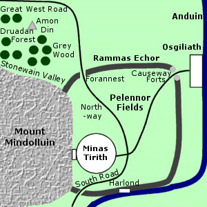
Pelennor FieldsFields outside Minas Tirith; site of the greatest battle of the War of the Ring. The Pelennor Fields were on the west bank of the Anduin. The land rand down toward the river in slopes and terraces. The City of Minas Tirith was in the southwestern corner of the Pelennor Fields at the foot of Mount Mindolluin. The fields were enclosed by an outer wall called the Rammas Echor.A road ran northeast across the Pelennor Fields to the Causeway Forts on the river bank - a distance of 12 miles. The North-wayled from the City through the fields to the Forannest, or North-gate, where it joined the Great West Road to Rohan. The South Road came from the southern provinces of Gondor and passed through the Pelennor Fields on the way to Minas Tirith. A number of other paths also criss-crossed the fields. The Pelennor Fields were fertile farmland. There were tilled fields and orchards, and small brooks flowed from the highlands down to the Anduin. Some farmers and herdsman lived on the Pelennor Fields and they had homesteads with barns and pens for livestock, granaries, and kilns for drying hops and malt. The people and livestock were evacuated from the Pelennor Fields during the War of the Ring. On March 13, 3019 of the Third Age, Sauron's forces broke through the Rammas Echor and overran the Pelennor Fields. The homesteads were destroyed and the fields and trees were burned. Trenches were dug across the Pelennor Fields and they were filled with fire. The armies of Sauron made great camps on the fields and brought siege-towers and engines of war forward to besiege the City. The Battle of the Pelennor Fields began at dawn on March 15 when the Rohirrim charged onto the Pelennor Fields. The Rohirrim and the Men of Gondor fought the forces of Sauron in a grueling day-long battle. Near the end of the day, most of the Orcs had been killed but some of the Easterlings and Haradrim held out among the ruined homesteads. Finally at sunset, the enemy forces were defeated. After the battle, the grass grew once more on the Pelennor Fields, especially in the place called Snowmane's Howe, where King Theoden's steed was buried. But a patch of black, scorched earth remained where the Fell Beast of the Lord of the Nazgul was burned. On May 1, people of Gondor and Rohan assembled on the Pelennor Fields to witness the coronation of Aragorn, King Elessar, before the gates of the City. Names &
Etymology:
Sources:
|
The Grey Mountains were inhabited by Dragons and the Withered Heath was their breeding ground. The Dragons were driven away for a time after Fram slew Scatha the Worm. Dwarves then established a colony in the Grey Mountains in 2210 of the Third Age, but the Dragons returned and the Dwarves fled in 2589.
Names &
Etymology:
A heath is an open wasteland
with heather and bushes but few trees. The vegetation was no doubt withered
by the Dragons' fire.
Sources:
The Hobbit:
"An Unexpected Party," p. 28; "Queer Lodgings," p. 137
Appendix
A of The Lord of the Rings: "Durin's Folk," p. 353
Appendix
B of The Lord of the Rings: "The Tale of Years," p. 368
The Wold was originally part of the province of Gondor called Calenardhon. In 2510 of the Third Age, Calenardhon was invaded by the Balchoth - a group of Men from Rhun who were under the influence of Sauron. Cirion, the Steward of Gondor, led the Northern Army to the Wold but the Balchoth cut them off and drove them over the Limlight to the Field of Celebrant. The Balchoth were defeated in the Battle of the Field of Celebrant with the help of Eorl and the Eotheod. Afterwards Cirion gave Calenardhon to the Eotheod and it became Rohan.
Men from the East continued to raid the Wold from across the Anduin. In 2545, Eorl was killed in battle against the Easterlings in the Wold. His son Brego drove the Easterlings from the Wold.
In the summer of 3018, the Nazgul passed through the Wold as they searched for the One Ring in the Vales of the Anduin. They returned to the Wold in September and were met by messengers from Mordor who ordered them to proceed to Isengard.
In late February of 3019, Uruk-hai from Isengard led by Ugluk captured Merry Brandybuck and Pippin Took at Amon Hen. They took their captives across the Eastemnet and into the southern part of the Wold. At the edge of Fangorn, the Uruk-hai were defeated by the Rohirrim led by Eomer and the Hobbits escaped. Aragorn, Legolas, and Gimli followed the Uruk-hai's trail and met Eomer near the edge of the Wold. They continued to the edge of Fangorn but the Hobbits were gone.
On March 11, Orcs from Dol Guldur attacked Lothlorien but they were repelled and were driven into the Wold. On March 12, the Orcs were defeated in the Wold by Treebeard and the Ents from Fangorn.
Names &
Etymology:
A wold is high, rolling,
open land without trees.
Sources:
The Two
Towers: "Riders of Rohan," p. 32, 42-43
The Return
of the King: "The Muster of Rohan," p. 78; "The Ride of the Rohirrim,"
p. 110; "Many Partings," p. 257
Appendix
A of The Lord of the Rings: "The House of Eorl," p. 345, 349
Unfinished
Tales: "Cirion and Eorl," p. 299-301; "The Hunt for the Ring," p. 338-39;
"The Battles of the Fords of Isen," p. 368
At dusk on September 23, 3018 of the Third Age, Frodo Baggins and his companions came to the point where the Stock Road went down into the Yale, but they chose the lane leading toward Woodhall.
Names &
Etymology:
Yale is from the Welsh iâl
meaning "fertile or cultivated upland."
Sources:
The Fellowship
of the Ring: Map of "A Part of the Shire"; "Three Is Company," p. 86
All entries are Copyright © by the Thain from former tuckborough.net. Please contact me if you are Thain or know anything about how to contact the original author.
2003-2011, The Thain's Book - thainsbook.minastirith.cz
- e-mail: thain at tuckborough.net