

An encyclopedia of Middle-earth and Numenor
|
|
|
|
|
|
|
|
|
|
|
|
|
|
| |
|
|
An encyclopedia of Middle-earth and Numenor |
|

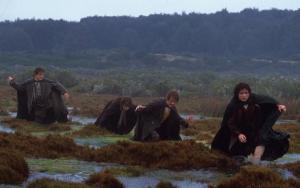
Dead Marshes |
Frodo
in the Dead Marshes
in the New Line film |
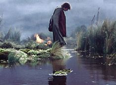 Marshes
near Mordor. The Dead Marshes were a vast network
of pools, mires, and waterways east of the Emyn
Muil. The wetlands were fed by many small rivers that ran down from
the hills. Reeds and grasses grew in the marshes and there were snakes
and worms and creatures in the water, but no birds. The air was thick with
mists and vapors and the Dead Marshes gave off a terrible stench.
Marshes
near Mordor. The Dead Marshes were a vast network
of pools, mires, and waterways east of the Emyn
Muil. The wetlands were fed by many small rivers that ran down from
the hills. Reeds and grasses grew in the marshes and there were snakes
and worms and creatures in the water, but no birds. The air was thick with
mists and vapors and the Dead Marshes gave off a terrible stench.
The Dead Marshes were located between the marshland called the Wetwang and the plain of Dagorlad where a great battle was fought during the War of the Last Alliance in 3434 of the Second Age. The marshland gradually expanded over the years and covered the graves of the Elves, Men, and Orcs who died in that battle.
The area became known as the Dead Marshes because the faces of the dead could still be seen in the wide pools in the middle of the marshes. How this was possible three millennia later is not known, but Frodo guessed it to be a trick of Sauron's foul arts. In the heavy mists around the Mere of Dead Faces there were flickering lights that were said to be the candles of corpses.
Gollum explored the Dead Marshes as he skulked around Mordor, and on February 1, 3018 of the Third Age, he was captured there by Aragorn. A year later on March 1, 3019, Gollum led Frodo Baggins and Sam Gamgee into the Dead Marshes, proposing to take them across by a secret path he had found. In this way they avoided crossing Dagorlad where they would most likely have been seen and captured.
Frodo was drawn to the dead faces in the water and had to be called away by Sam. During the night, a Winged Nazgul passed overhead. Gollum was terrified and from that moment on Sam sensed a change for the worse in their guide. They emerged from the Dead Marshes on the morning of March 2.
Sources:
The Fellowship
of the Ring: "The Council of Elrond," p. 266
The Two
Towers: "The Passage of the Marshes," passim; "The Window on the West,"
p. 275
Appendix
A of The Lord of the Rings: "Gondor and the Heirs of Anarion," p. 329
Unfinished
Tales: "The Hunt for the Ring," p. 342
The Riders of Rohan rode through the Fenmarch on their way to Minas Tirith on March 11, 3019 of the Third Age.
Names &
Etymology:
Fen is another word for "marsh,"
while march means "borderland." Tolkien noted that a more accurate
spelling in the language of Rohan would be Fenmark.
Sources:
The Two
Towers: "The Muster of Rohan," p. 77-78
"Nomenclature
of The Lord of the Rings," entry for Fenmarch
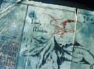
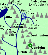
Fen of Serech |
Map
of the Fen of Serech
|
 Marshes
in Beleriand. The Fen of Serech was located at the northern end of the
Pass of Sirion between the Ered Wethrin and the highlands of Dorthonion.
The wetlands were formed at the juncture of the Sirion and the Rivil.
North of the Fen of Serech were the plains of Ard-galen
which later became the desert of Anfauglith.
Marshes
in Beleriand. The Fen of Serech was located at the northern end of the
Pass of Sirion between the Ered Wethrin and the highlands of Dorthonion.
The wetlands were formed at the juncture of the Sirion and the Rivil.
North of the Fen of Serech were the plains of Ard-galen
which later became the desert of Anfauglith.
The Fen of Serech was the site of several battles. During the Battle-under-Stars in 1497 of the Years of the Trees, Feanor's son Celegorm waylaid two of Morgoth's armies on Ard-galen and drove them into the Fen of Serech. Only a small number survived to return to Angband.
During the Battle of Sudden Flame in 455 of the First Age, Finrod Felagund brought his army north through the Pass of Sirion. Finrod and a small company were cut off from their main host by Morgoth's forces and were surrounded in the Fen of Serech. Barahir and a company of Men of the House of Beor rescued them, and Finrod swore and oath of friendship to Barahir and his kin.
At sunset on the sixth day after Midsummer in 472, the Battle of Unnumbered Tears ended in the Fen of Serech with the last stand of the Men of Dor-lomin. Hurin and Huor and the Men of Dor-lomin covered the retreat of Turgon and the Elves of Gondolin through the Pass of Sirion. The Men crossed the Rivil and then stood their ground against the enemy. Hurin was taken captive but Huor and the rest of the Men were all slain.
Names & Etymology:
Gladden Fields |
Smeagol
and Deagol fishing in the Gladden Fields
in the New Line film |
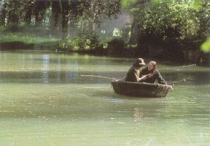 Marshes
on the banks of the Anduin. The Gladden
Fields were located around the mouth of the Gladden
River where it flowed into the Anduin from the west. The marshlands
extened to the eastern bank of the Anduin as well. It was a region of dark
pools and islets and beds of reeds and rushes. Yellow irises also grew
there in profusion, some of which were taller than a Man.
Marshes
on the banks of the Anduin. The Gladden
Fields were located around the mouth of the Gladden
River where it flowed into the Anduin from the west. The marshlands
extened to the eastern bank of the Anduin as well. It was a region of dark
pools and islets and beds of reeds and rushes. Yellow irises also grew
there in profusion, some of which were taller than a Man.
In ancient times when the Silvan Elves first came to the region, there was a lake where the waters of the Anduin and the Gladden River merged. But over time the waters receded and the wetlands of the Gladden Fields were formed.
Isildur travelled north on a path that ran between Mirkwood and the Gladden Fields on his way to Rivendell in the year 2 of the Third Age. As he and his men passed the northern edge of the Gladden Fields, they were attacked by Orcs. Isildur's three eldest sons and all but three of his men were slain.
Isildur tried to escape by putting on the One Ring and fleeing into the Anduin, but the current pulled him into the marshes of the Gladden Fields and he became entangled in the rushes. The Ring slipped from his hand and fell to the bottom of the river. Isildur managed to reach an islet near the western shore when he was seen by Orcs who slew him with poisoned arrows.
The Ring lay in the dark waters of the Gladden Fields until 2463, when it was found by Deagol, who was fishing with his friend Smeagol. Deagol and Smeagol were descendants of the Stoors who had settled by the banks of the Anduin near the Gladden Fields around 1356. Smeagol strangled Deagol and took the Ring for himself and went into hiding in the Misty Mountains.
In 2851, Saruman began to search the Gladden Fields for the Ring that Isildur had borne. When the White Council met that year, Saruman overruled Gandalf's recommendation that they drive Sauron out of Dol Guldur on the edge of Mirkwood south of the Gladden Fields. Saruman hoped that the Ring would reveal itself by attempting to return to its Master.
Sauron also sent his servants to the Gladden Fields to seek the Ring. Saruman learned of this, and when Gandalf once again suggested an attack on Dol Guldur in 2941, Saruman agreed to prevent the Dark Lord from finding the Ring. At the meeting of the White Council in 2953, Saruman pretended that he had learned that the Ring had been carried downriver to the Sea.
At some point during his search of the Gladden Fields, Saruman found the Elendilmir. This was the token of royalty of the North-kingdom which Isildur had been wearing when he was slain. It is possible that Saruman also found Isildur's body at this time, but it is not known whether he removed Isildur's remains or whether he left the bones to lie in the pools of the Gladden Fields.
Names &
Etymology:
The word gladden is from
the Anglo-Saxon glædene, meaning "iris," referring to the
yellow irises that grew in the Gladden Fields.
Called Loeg Ningloron in Sindarin, meaning "pools of the golden water-flowers." The word loeg is probably derived from the stem log meaning "wet, soaked, swampy." The word ninglor means "golden waters" from nin meaning "waters" and glor or glaur meaning "gold."
Sources:
The Fellowship
of the Ring: "The Shadow of the Past," p. 61-63; "The Council of Elrond,"
p. 257, 267; "The Ring Goes South," p. 287
Appendix
B of The Lord of the Rings: "The Tale of Years," p. 368, 369 and note,
370
Unfinished
Tales: "The History of Galadriel and Celeborn - Appendix D: The Port
of Lond Daer," p. 263 (definition of log); "The Disaster of the
Gladden Fields," passim (see especially note 13); index entry for "Loeg
Ningloron" (definition)
The History
of Middle-earth, vol. V, The Lost Road and Other Writings: "The Etymologies,"
entries for GLAW(R) and NEN
Letters
of J.R.R. Tolkien: Letter #297
The Hobbits of the Marish were predominantly of Stoor descent. They were large and heavy-legged and many of the men grew beards. They were also unusual in that they sometimes wore dwarf-boots in muddy weather. They mainly lived in houses, and in fact the practice of building houses rather than Hobbit-holes was said to have begun in the Marish. The Marish had been settled later than other parts of the Shire, an the inhabitants had come mainly from the south. They retained a number of their own words and names.
The first Thain of the Shire was Bucca of the Marish, from whom the Oldbuck family was descended. Gorhendad Oldbuck led his family across the Brandywine to establish Buckland in 2340. The farmers of the Marish still recognized the authority of the Master of Buckland.
On September 25, 3018 of the Third Age, Frodo Baggins decided to take a shortcut across the Marish to the Bucklebury Ferry. Pippin Took warned him that the terrain was difficult, but they proceeded. The Hobbits became disoriented in the Woody End and emerged on Farmer Maggot's lands. From Maggot they learned that a Black Rider had come through the Marish earlier that day seeking Baggins. Merry Brandybuck met his friends at the Bucklebury Ferry and the four Hobbits crossed into Buckland that evening.
Names &
Etymology:
Marish is an old form of
"marsh."
Sources:
The Fellowship
of the Ring: "Prologue: Concerning Hobbits," p. 15; "A Short Cut to
Mushrooms," p. 97, 100-101, 106; "A Conspiracy Unmasked," p. 108-109
"Nomenclature
of The Lord of the Rings," entry for Marish
Midgewater Marshes |
Hobbits
in the Midgewater Marshes in the New
Line film
|
 Marshes
in Eriador. The Midgewater Marshes were east
of Bree. The Chetwood
was on the western side of the marshes and the Weather
Hills were on the east. The Great
East Road curved around the southern edge of the Midgewater Marshes.
Marshes
in Eriador. The Midgewater Marshes were east
of Bree. The Chetwood
was on the western side of the marshes and the Weather
Hills were on the east. The Great
East Road curved around the southern edge of the Midgewater Marshes.
The land in the marshes was boggy and treacherous and there was no permanent path. There were many pools and reeds and rushes. The marshes were home to birds, flies, tiny biting midges, and loud cricket-like insects that Sam Gamgee named Neekerbreekers.
The Hobbits were led into the Midgewater Marshes by Strider on October 2, 3018 of the Third Age, their third day out of Bree. They spent two uncomfortable days and nights in the marshes.
Names &
Etymology:
The Midgewater Marshes are named
for the small insects called
midges that lived there.
Sources:
The Fellowship
of the Ring: "A Knife in the Dark," 194-95
The Journeys
of Frodo by Barbara Strachey: Map #11, "Bree to Weathertop"
Names &
Etymology:
A bourn is a small stream
or brook. The Overbourn Marshes may have been so named because they were
across the Shirebourn from the most populous part of the Eastfarthing.
Or the first element may come from the Old English ofer meaning
"border, riverbank."
Source:
The Fellowship
of the Ring: Map of "A Part of the Shire"
The Lord
of the Rings: A Reader's Companion by Wayne G. Hammond and Christina
Scull: "The Maps of The Lord of the Rings," p. lviii
Names &
Etymology:
The name Rushock is composed
of rush - a plant commonly found in swamplands - and hassock
or "coarse grass."
Source:
The Fellowship
of the Ring: Map of "A Part of the Shire"
The Lord
of the Rings: A Reader's Companion by Wayne G. Hammond and Christina
Scull: "The Maps of The Lord of the Rings," p. lix
Swanfleet (Nîn-in-Eilph) |
Map
of Swanfleet and surrounding area
|
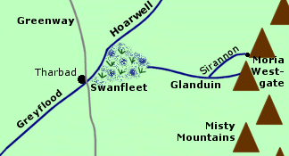 Wetlands
on the southern border of Eriador. Swanfleet
was a region of swamps, pools, and eyots - or small islands. Many water
birds lived there among the reeds, particularly swans.
Wetlands
on the southern border of Eriador. Swanfleet
was a region of swamps, pools, and eyots - or small islands. Many water
birds lived there among the reeds, particularly swans.
The Glanduin flowed west from the Misty Mountains into the wetlands of Swanfleet. At its eastern end, the waters of Swanfleet merged with the River Hoarwell and formed the Greyflood. The city of Tharbad was located near this juncture. The construction of Tharbad had required drainage and the building of dikes, but by the end of the Third Age, Tharbad was deserted and the area had returned to wild wetlands.
On their way home in September 3019 of the Third Age, Frodo Baggins and his companions crossed the Glanduin and saw the meres and eyots of Swanfleet away to the west.
Note:
The text of The
Return of the King refers to the Swanfleet river (lowercase
r).
Tolkien later clarified that by this he meant the Glanduin as the river
that flowed into Swanfleet.
Names &
Etymology:
The word fleet is an archaic
term for an estuary - the mouth of a river - from the the Old English fleot.
The Sindarin name was Nîn-in-Eilph meaning "waterlands of
the swans." The word nîn means "waters." The word eilph
is the plural of alph meaning "swan."
Sources:
The Return
of the King: "Many Partings," p. 263
Unfinished
Tales: "The History of Galadriel and Celeborn - Appendix D: The Port
of Lond Daer," p. 264-65 and passim
The History
of Middle-earth, vol. V, The Lost Road and Other Writings: "The Etymologies,"
entry for NEN
Names &
Etymology:
The word wang means "field,
flat area." Nindalf is the Sindarin name from nîn meaning
"wet" and talf meaning "flat field."
Sources:
Map of
Middle-earth by J.R.R. Tolkien
The Fellowship
of the Ring: "Farewell to Lorien," p. 389
"Nomenclature
of The Lord of the Rings," entry for Wetwang
All entries are Copyright © by the Thain from former tuckborough.net. Please contact me if you are Thain or know anything about how to contact the original author.
2003-2012, The Thain's Book - thainsbook.minastirith.cz
- e-mail: thain at tuckborough.net